

A | B | C | D | E | F | G | H | CH | I | J | K | L | M | N | O | P | Q | R | S | T | U | V | W | X | Y | Z | 0 | 1 | 2 | 3 | 4 | 5 | 6 | 7 | 8 | 9
San Francisco Bay Area | |
|---|---|
 Location of the Bay Area within California. The nine-county Bay Area. Additional counties in the larger thirteen-county combined statistical area. | |
| Country | United States |
| State | California |
| Subregions | |
| Counties | |
| Core cities | Oakland San Francisco San Jose |
| Other municipalities | |
| Area | |
| • Nine-county | 6,966 sq mi (18,040 km2) |
| • San Jose-San Francisco-Oakland (CSA) | 10,191 sq mi (26,390 km2) |
| Highest elevation | 4,360 ft (1,330 m) |
| Lowest elevation | −13 ft (−4 m) |
| Population (2020) | |
| • Nine-county | 7.76 million[4] |
| • San Jose-San Francisco-Oakland (CSA) | 9.71 million[4] |
| GDP | |
| • Nine-county | $729.105 billion (2022) |
| • San Jose-San Francisco-Oakland (CSA) | $1.383 trillion (2022) |
| Time zone | UTC−08:00 (Pacific) |
| • Summer (DST) | UTC−07:00 (PDT) |
| Area codes | 408/669, 415/628, 510/341, 650, 707, 925[7] |
| Website | bayareametro |
.jpg)

.jpg)
.jpg)
.jpg)

.jpg)
The San Francisco Bay Area, commonly known as the Bay Area, is a region of California surrounding and including the San Francisco Bay.[8] The Association of Bay Area Governments defines the Bay Area as including the nine counties that border the estuaries of San Francisco Bay, San Pablo Bay, and Suisun Bay: Alameda, Contra Costa, Marin, Napa, San Mateo, Santa Clara, Solano, Sonoma, and San Francisco. Other definitions may be either smaller or larger, and may include neighboring counties such as the Central Coast counties of Santa Cruz, San Benito, and Monterey, or the Central Valley counties of San Joaquin, Merced, and Stanislaus.[9] The Bay Area is known for its natural beauty, progressive politics, prominent universities, technology companies, and affluence. The Bay Area contains many cities, towns, airports, and associated regional, state, and national parks, connected by a complex multimodal transportation network.
The earliest archaeological evidence of human settlements in the Bay Area dates back to 8000–10,000 BC. The oral tradition of the Ohlone and Miwok people suggests they have been living in the Bay Area for several hundreds if not thousands of years.[10][11] The Spanish empire claimed the area beginning in the early period of Spanish colonization of the Americas. The earliest Spanish exploration of the Bay Area took place in 1769. The Mexican government controlled the area from 1821 until the 1848 Treaty of Guadalupe Hidalgo. Also in 1848, James W. Marshall discovered gold in nearby mountains, resulting in explosive immigration to the area and the precipitous decline of the Native population. The California Gold Rush brought rapid growth to San Francisco.[12] California was admitted as the 31st state in 1850. A major earthquake and fire leveled much of San Francisco in 1906. During World War II, the Bay Area played a major role in America's war effort in the Asiatic-Pacific Theater, with the San Francisco Port of Embarkation, of which Fort Mason was one of 14 installations and location of the headquarters, acting as a primary embarkation point for American forces. Since then, the Bay Area has experienced numerous political, cultural, and artistic movements, developing unique local genres in music and art and establishing itself as a hotbed of progressive politics. Economically, the post-war Bay Area saw large growth in the financial and technology industries, creating an economy with a gross domestic product of over $700 billion. In 2018 it was home to the third-highest concentration of Fortune 500 companies in the United States.[13][14]
The Bay Area is home to approximately 7.52 million people.[15] The larger federal classification, the combined statistical area of the region which includes 13 counties,[9] is the second-largest in California—after the Greater Los Angeles area—and the fifth-largest in the United States, with over 9 million people.[16] The Bay Area's population is ethnically diverse: roughly three-fifths of the region's residents are Hispanic, Asian, African American, or Pacific Islander, all of whom have a significant presence throughout the region. Most of the remaining two-fifths of the population is non-Hispanic White American. The most populous cities of the Bay Area are Oakland, San Francisco, and San Jose, the latter of which in 2022 had population of 971,233, making it the 12th-most populous in the United States.[17][18]
Despite its urban character, the San Francisco Bay is one of California's most ecologically sensitive habitats, providing important ecosystem services such as filtering the pollutants and sediments from rivers and supporting a number of endangered species. In addition, the Bay Area is known for its stands of coast redwoods, many of which are protected in state and county parks. The region is additionally known for the complexity of its landforms, the result of millions of years of tectonic plate movements. Because the Bay Area is crossed by 6 major earthquake faults, the region is particularly exposed to hazards presented by large earthquakes. The climate is temperate and conducive to outdoor recreational and athletic activities such as hiking, running, and cycling. The Bay Area is host to 6 professional sports teams and is a cultural center for music, theater, and the arts. It is also host to numerous higher education institutions, including research universities such as Stanford University and the University of California, Berkeley. Home to 101 municipalities and 9 counties, governance in the Bay Area involves numerous local and regional jurisdictions, often with broad and overlapping responsibilities.
History

The Coyote Hills Shell Mound, the earliest known archaeological evidence of human habitation of the Bay Area estuaries, dates to around 10,000 BCE, with evidence pointing to even earlier settlement in Point Reyes in Marin County.[19] It has been conjectured that the people living in the Bay Area at the time of first European contact were descended from Siberian tribes who arrived at around 1,000 BCE by sailing over the Arctic Ocean and following the salmon migration.[20] However the current academic consensus is compatible with the oral tradition of the Ohlone and Miwok peoples, which suggests they have been living in the Bay Area for several hundreds if not thousands of years.[10][11]
At the time of colonization, the Ohlone peoples in the Bay Area primarily lived on the San Francisco Peninsula, in the South Bay and in the East Bay, and the Miwok primarily lived in the North Bay, northern East Bay, and Central Valley. Ohlone villages were spread across the Peninsula, East Bay, South Bay, as well as further south into the Monterey Bay area.[21] There were eight major divisions of Ohlone people, four of which were based in the Bay Area: the Karkin of the Carquinez Strait, the Chochenyo of the East Bay, the Ramaytush of the San Francisco Peninsula, and the Tamien of the South Bay. The Miwok had two major groups in the Bay Area: the Bay Miwok of Contra Costa and the Coast Miwok of Marin and Sonoma.
In 1542, Juan Rodríguez Cabrillo explored the Pacific coast near the Bay Area though the expedition did not see the Golden Gate or the estuaries, likely due to fog. Sir Francis Drake became the first European to land in the area and claim it in June 1579, when he landed at Drakes Bay near Point Reyes. Even though he claimed the region for Queen Elizabeth I as Nova Albion or New Albion, the English made no immediate follow up to the claim.[22][23][24]
In 1595, Philip II of Spain tasked Sebastião Rodrigues Soromenho with mapping the west coast of the Americas. Soromenho set sail on Manila Galleon San Agustin on July 5, 1595 and in early November they reached land between Point St. George and Trinidad Head, north of the Bay Area, in the Lost Coast. The expedition followed the coast southward and on November 7 the San Agustin anchored in Drakes Bay, and claimed the region as Puerto y Bahía de San Francisco.[25][26][27] In late November, a storm sank the San Agustin and killed between 7 and 12 people. On December 8, 80 remaining crew members set sail on the San Buenaventura, a launch which was partially constructed en route from the Philippines. Seeking the fastest route south, the expedition sailed past the Golden Gate, arriving at Puerto de Chacala, Mexico on January 17, 1596.[28]
_(cropped).jpg)

The Bay Area estuaries remained unknown to Europeans until members of the Portolá expedition, while trekking along the California coast, encountered it in 1769 when the Golden Gate blocked their continued journey north.[29] Several missions were founded in the Bay Area during this period. In 1806, a Spanish expedition led by Gabriel Moraga began at the Presidio, traveled south of the bay, and then east to explore the San Joaquin Valley.[30]
In 1821, Mexico gained its independence from Spain and the Bay Area became part of the Mexican province of Alta California, a period characterized by ranch life and visiting American trappers.[31] Mexico's control of the territory would be short-lived, however, and in 1846 a party of settlers occupied Sonoma Plaza and proclaimed the independence of the new Republic of California.[31] That same year, the Mexican–American War began, and American captain John Berrien Montgomery sailed the USS Portsmouth into the bay and seized San Francisco, which was then known as Yerba Buena, and raised the American flag for the first time over Portsmouth Square.[32]

In 1848, James W. Marshall's discovery of gold in the American River sparked the California Gold Rush, and within half a year 4,000 men were panning for gold along the river and finding $50,000 per day.[33] The promise of fabulous riches quickly led to a stampede of wealth-seekers descending on Sutter's Mill. The Bay Area's population quickly emptied out as laborers, clerks, waiters, and servants joined the rush to find gold, and California's first newspaper, The Californian, was forced to announce a temporary freeze in new issues due to labor shortages.[33] By the end of 1849, news had spread across the world and newcomers flooded into the Bay Area at a rate of one thousand per week on their way to California's interior,[33] including the first large influx of Chinese immigrants to the U.S.[34] The rush was so great that vessels were abandoned by the hundreds in San Francisco's ports as crews rushed to the goldfields.[35] The unprecedented influx of new arrivals spread the nascent government authorities thin, and the military was unable to prevent desertions. As a result, numerous vigilante groups formed to provide order, but many tasked themselves with forcibly moving or killing local Native Americans, and by the end of the Gold Rush, two thirds of the indigenous population had been killed.[36]
.jpg)
During this same time, a constitutional convention was called to determine California's application for statehood into the United States. After statehood was granted, the capital city moved between three cities in the Bay Area: San Jose (1849–1851), Vallejo (1851–1852), and Benicia (1852–1853) before permanently settling in Sacramento in 1854.[37] As the Gold Rush subsided, wealth generated from the endeavor led to the establishment of Wells Fargo Bank and the Bank of California, and immigrant laborers attracted by the promise of wealth transformed the demographic makeup of the region. Construction of the First transcontinental railroad from the Oakland Long Wharf attracted so many laborers from China that by 1870, eight percent of San Francisco's population was of Asian origin.[38] The completion of the railroad connected the Bay Area with the rest of the United States, established a truly national marketplace for the trade of goods, and accelerated the urbanization of the region.[39]

In the early morning of April 18, 1906, a large earthquake with an epicenter near the city of San Francisco hit the region.[40] Immediate casualty estimates by the U.S. Army's relief operations were 498 deaths in San Francisco, 64 deaths in Santa Rosa, and 102 in or near San Jose, for a total of about 700. More recent studies estimate the total death count to be over 3,000, with over 28,000 buildings destroyed.[41] Rebuilding efforts began immediately. Amadeo Peter Giannini, owner of the Bank of Italy (now known as the Bank of America), had managed to retrieve the money from his bank's vaults before fires broke out through the city and was the only bank with liquid funds readily available and was instrumental in loaning out funds for rebuilding efforts.[42] Congress immediately approved plans for a reservoir in Hetch Hetchy Valley in Yosemite National Park, a plan they had denied a few years earlier, which now provides drinking water for 2.4 million people in the Bay Area. By 1915, the city had been sufficiently rebuilt and advertised itself to the world during the Panama Pacific Exposition that year, although the effects of the quake hastened the loss of the region's dominant status in California to the Los Angeles metropolitan area.[42]
During the 1929 stock market crash and subsequent economic depression, not a single San Francisco-based bank failed,[43] while the region attempted to spur job growth by simultaneously undertaking two large infrastructure projects: construction of the Golden Gate Bridge, which would connect San Francisco with Marin County,[44] and the Bay Bridge, which would connect San Francisco with Oakland and the East Bay.[45] After the United States joined World War II in 1941, the Bay Area became a major domestic military and naval hub, with large shipyards constructed in Sausalito and across the East Bay to build ships for the war effort.[46] The Army's San Francisco Port of Embarkation was the primary origin for Army forces shipping out to the Pacific Theater of Operations.[47][48] That command consisted of fourteen installations including Fort Mason, the Oakland Army Base, Camp Stoneman and Fort McDowell in San Francisco Bay and the sub port of Los Angeles.[49]
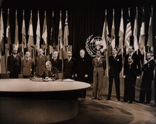
After World War II, the United Nations was chartered in San Francisco, and in September 1951, the Treaty of San Francisco to re-establish peaceful relations between Japan and the Allied Powers was signed in San Francisco, entering into force a year later.[50] In the years immediately following the war, the Bay Area saw a huge wave of immigration as populations increased across the region. Between 1950 and 1960, San Francisco welcomed over 100,000 new residents, inland suburbs in the East Bay saw their populations double, Daly City's population quadrupled, and Santa Clara's population quintupled.[46]
.jpg)
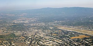
By the early 1960s, the Bay Area and the rest of Northern California became the center of the counterculture movement. Telegraph Avenue in Berkeley and the Haight-Ashbury neighborhood in San Francisco were seen as centers of activity,[51] with the hit American pop song San Francisco (Be Sure to Wear Flowers in Your Hair) further enticing like-minded individuals to join the movement in the Bay Area and leading to the Summer of Love.[52] In the proceeding decades, the Bay Area would cement itself as a hotbed of New Left activism, student activism, opposition to the Vietnam War and other anti-war movements, the black power movement, and the gay rights movement.[51] At the same time, parts of San Mateo and Santa Clara counties began to rapidly develop from an agrarian economy into a hotbed of the high-tech industry.[53] Fred Terman, the director of a top-secret research project at Harvard University during World War II, joined the faculty at Stanford University in order to reshape the university's engineering department. His students, including David Packard and William Hewlett, would later help usher in the region's high-tech revolution.[46] In 1955, Shockley Semiconductor Laboratory opened for business in Mountain View near Stanford, and although the business venture was a financial failure, it was the first semiconductor company in the Bay Area, and the talent that it attracted to the region eventually led to a high-tech cluster of companies later known as Silicon Valley.[54]

In 1989, in the middle of a World Series game between two Bay Area baseball teams, the Loma Prieta earthquake struck and caused widespread infrastructural damage, including the failure of the Bay Bridge, a major link between San Francisco and Oakland.[55] Even so, the Bay Area's technology industry continued to expand and growth in Silicon Valley accelerated: the United States census confirmed that year that San Jose had overtaken San Francisco in terms of population.[56] The commercialization of the Internet in the middle of the decade rapidly created a speculative bubble in the high-tech economy known as the dot-com bubble. This bubble began collapsing in the early 2000s and the industry continued contracting for the next few years, nearly wiping out the market. Companies like Amazon.com and Google managed to weather the crash however, and following the industry's return to normalcy, their market value increased significantly.[57]
Even as the growth of the technology sector transformed the region's economy, progressive politics continued to guide the region's political environment. By the turn of the millennium, non-Hispanic whites, the largest ethnic group in the United States, were only half of the population in the Bay Area as immigration among minority groups accelerated.[58] During this time, the Bay Area was the center of the LGBT rights movement: in 2004, San Francisco began issuing marriage licenses to same-sex couples, a first in the United States,[59] and four years later a majority of voters in the Bay Area rejected California Proposition 8, which sought to constitutionally restrict marriage to opposite-sex couples but ultimately passed statewide.[60]
.jpg)
The Bay Area was also the center of contentious protests concerning racial and economic inequality. In 2009, an African-American man named Oscar Grant was fatally shot by Bay Area Rapid Transit police officers, precipitating widespread protests across the region and even riots in Oakland.[61] His name was symbolically tied to the Occupy Oakland protests two years later that sought to fight against social and economic inequality.[62]
By August 2023, San Francisco was in such severe decline that Mayor Matt Mahan of San Jose joked that one day the region might be renamed the "San Jose Bay Area", after its largest and most prosperous city.[63]
Geography
Boundaries
.svg)
The borders of the San Francisco Bay Area are not officially delineated, and the unique development patterns influenced by the region's topography, as well as unusual commute patterns caused by the presence of three central cities and employment centers located in various suburban locales, has led to considerable disagreement between local and federal definitions of the area.[64] Because of this, professor of geography at the University of California, Berkeley Richard Walker claimed that "no other U.S. city-region is as definitionally challenged ."[64]
When the region began to rapidly develop during and immediately after World War II, local planners settled on a nine-county definition for the Bay Area, consisting of the counties that directly border the San Francisco, San Pablo, and Suisun estuaries: Alameda, Contra Costa, Marin, Napa, San Francisco, San Mateo, Santa Clara, Solano, and Sonoma counties.[65] Today, this definition is accepted by most local governmental agencies including San Francisco Regional Water Quality Control Board,[66] Bay Area Air Quality Management District,[67] the San Francisco Bay Restoration Authority,[68] the Metropolitan Transportation Commission,[69] and the Association of Bay Area Governments,[70] the latter two of which partner to deliver a Bay Area Census using the nine-county definition.[71]
Various U.S. Federal government agencies use definitions that differ from their local counterparts' nine-county definition. For example, the Federal Communications Commission (FCC) which regulates broadcast, cable, and satellite transmissions, includes nearby Colusa, Lake and Mendocino counties in their "San Francisco-Oakland-San Jose" media market, but excludes eastern Solano county.[72] On the other hand, the United States Office of Management and Budget, which designates metropolitan statistical areas (MSAs) and combined statistical areas (CSA) for populated regions across the country, has five MSAs which include, wholly or partially, areas within the nine-county definition, and one CSA which includes eight Bay Area counties (excluding Sonoma), but including neighboring San Benito, Santa Cruz, San Joaquin, Merced, and Stanislaus counties.[9]
The Association of Bay Area Health Officers (ABAHO), an organization that has fought local outbreaks of HIV/AIDS in 1980s and with COVID-19 pandemic and Deltacron hybrid variant (2020–22), consists of the public health officers of 9 Bay Area counties, in addition to the Central Coast counties of Santa Cruz, San Benito, and Monterey and the city of Berkeley.
| County | 2022 estimate | 2020–22 change |
2020 Population | 2010 Population | 2010–20 change |
2020 Density (per sq mi) | MSA |
|---|---|---|---|---|---|---|---|
| Alameda | 1,628,997 | -3.2% | 1,682,353 | 1,510,271 | +11.4% | 2,281.3 | San Francisco–Oakland–Berkeley |
| Contra Costa | 1,156,966 | -0.8% | 1,165,927 | 1,049,025 | +11.1% | 1,626.3 | |
| Marin | 256,018 | -2.4% | 262,321 | 252,409 | +3.9% | 504.1 | |
| San Francisco | 808,437 | -7.5% | 873,965 | 805,235 | +8.5% | 18,629.1 | |
| San Mateo | 729,181 | -4.6% | 764,442 | 718,451 | +6.4% | 1,704.0 | |
| San Benito | 67,579 | +5.3% | 64,209 | 55,269 | +16.2% | 46.2 | San Jose–Sunnyvale–Santa Clara |
| Santa Clara | 1,870,945 | -3.4% | 1,936,259 | 1,781,642 | +8.7% | 1,499.7 | |
| Napa | 134,300 | -2.7% | 138,019 | 136,484 | +1.1% | 184.4 | Napa |
| Solano | 448,747 | -1.0% | 453,491 | 413,344 | +9.7% | 551.8 | Vallejo–Fairfield |
| Sonoma† | 482,650 | -1.3% | 488,863 | 483,878 | +1.0% | 310.3 | Santa Rosa–Petaluma |
| Merced | 290,014 | +3.1% | 281,202 | 255,793 | +9.9% | 145.1 | Merced |
| Santa Cruz | 264,370 | -2.4% | 270,861 | 262,382 | +3.2% | 608.5 | Santa Cruz–Watsonville |
| San Joaquin | 793,229 | +1.3% | 779,233 | 685,306 | +13.7% | 559.6 | Stockton–Lodi |
| Stanislaus | 551,275 | -0.3% | 552,878 | 514,453 | +7.5% | 369.6 | Modesto |
Subregions
Among locals, the nine-county Bay Area is divided into five sub-regions: the East Bay, North Bay, Peninsula, city of San Francisco, and South Bay.
The "East Bay" is the densest region of the Bay Area outside of San Francisco and includes cities and towns in Alameda and Contra Costa counties centered around Oakland. As one of the larger subregions, the East Bay includes a variety of enclaves, including the suburban Tri-Valley area and the highly urban western part of the subregion that runs alongside the bay, including Oakland.[74]
The "North Bay" includes Marin, Sonoma, Napa, and Solano counties, and is the largest and least populated subregion. The western counties of Marin and Sonoma are encased by the Pacific Ocean on the west and the bay on the east and are characterized by their mountainous and woody terrain. Sonoma and Napa counties are known internationally for their grape vineyards and wineries, and Solano County to the east, centered around Vallejo, is the fastest growing region in the Bay Area.[75]
- Regions of the Bay Area
-
 East Bay
 -
 South Bay
 -
 North Bay
 -
 Peninsula
.jpg)
.jpg)


The "Peninsula" subregion includes the cities and towns on the San Francisco Peninsula, excluding the titular city of San Francisco. Its eastern half, which runs alongside the Bay, is highly populated, while its less populated western coast traces the coastline of the Pacific Ocean and is known for its open space and hiking trails. Roughly coinciding with the borders of San Mateo County, it also includes the northwestern Santa Clara County cities of Palo Alto, Mountain View, and Los Altos.[76]
Although geographically located on the tip of the San Francisco Peninsula, the city of San Francisco is not considered part of the "Peninsula" subregion, but as a separate entity.[77][78]
The term "South Bay" has different meanings to different groups: Writing in 1959 for the Army Corps of Engineers, the United States Department of Commerce defined the South Bay as comprising five counties, corresponding to their two-way division of the bay into north and south regions.[79] In 1989, the federal Environmental Protection Agency defined the South Bay as the northern part of Santa Clara County and the southeastern part of San Mateo County.[80] This latter definition corresponds to common usage.[81]
Climate

The Bay Area is located in the warm-summer Mediterranean climate zone (Köppen Csb) that is a characteristic of California's coast, featuring mild to cool winters with occasional rainfall, and warm to hot, dry summers.[82] It is largely influenced by the cold California Current, which penetrates the natural mountainous barrier along the coast by traveling through various gaps.[83] In terms of precipitation, this means that the Bay Area has pronounced seasons. The winter season, which roughly runs between November and March, is the source of about 82% of annual precipitation in the area. In the South Bay and further inland, while the winter season is cool and mild, the summer season is characterized by warm sunny days,[83] while in San Francisco and areas closer to the Golden Gate strait, the summer season is periodically affected by fog.[84]

Due to the Bay Area's diverse topographic relief (itself the result of the clashing tectonic plates), the region is home to numerous microclimates that lead to pronounced differences in climate and temperature over short distances.[82][85] Within the city of San Francisco, natural and artificial topographical features direct the movement of wind and fog, resulting in startlingly varied climates between city blocks. Along the Golden Gate Strait, oceanic wind and fog from the Pacific Ocean are able to penetrate the mountain barriers inland into the Bay Area.[85]
During the summer, rising hot air in California's interior valleys creates a low pressure area that draws winds from the North Pacific High through the Golden Gate, which creates the city's characteristic cool winds and fog.[84] The microclimate phenomenon is most pronounced during this time, when fog penetration is at its maximum in areas near the Golden Gate strait,[85] while the South Bay and areas further inland are sunny and dry.[83]
.jpg)
Along the San Francisco peninsula, gaps in the Santa Cruz Mountains, one south of San Bruno Mountain and another in Crystal Springs, allow oceanic weather into the interior, causing a cooling effect for cities along the Peninsula and even as far south as San Jose. This weather pattern is also the source for delays at San Francisco International Airport. In Marin county north of the Golden Gate strait, two gaps north of Muir Woods bring cold air across the Marin Headlands, with the cooling effect reaching as far north as Santa Rosa.[85] Further inland, the East Bay receives oceanic weather that travels through the Golden Gate strait, and further diffuses that air through the Berkeley Hills, Niles Canyon and the Hayward Pass into the Livermore Valley and Altamont Pass. Here, the resulting breeze is so strong that it is home to one of the world's largest array of wind turbines. Further north, the Carquinez Strait funnels the ocean weather into the San Joaquin River Delta, causing a cooling effect in Stockton and Sacramento, so that these cities are also cooler than their Central Valley counterparts in the south.[85]
| City | Jan | Feb | Mar | Apr | May | Jun | Jul | Aug | Sep | Oct | Nov | Dec |
|---|---|---|---|---|---|---|---|---|---|---|---|---|
| Fairfield[86] | 55 / 39 (13 / 4) |
61 / 42 (16 / 6) |
66 / 45 (19 / 7) |
71 / 47 (22 / 8) |
78 / 52 (26 / 11) |
85 / 56 (29 / 13) |
90 / 58 (32 / 14) |
89 / 57 (32 / 14) |
86 / 56 (30 / 13) |
78 / 51 (26 / 11) |
65 / 44 (18 / 7) |
55 / 39 (13 / 4) |
| Oakland[87] | 58 / 44 (14 / 7) |
67 / 47 (19 / 8) |
64 / 49 (18 / 9) |
66 / 50 (19 / 10) |
69 / 53 (21 / 12) |
72 / 55 (22 / 13) |
72 / 56 (22 / 13) |
73 / 58 (23 / 14) |
74 / 57 (23 / 14) |
72 / 54 (22 / 12) |
65 / 49 (18 / 9) |
58 / 45 (14 / 7) |
| San Francisco[88] | 57 / 46 (14 / 8) |
60 / 48 (16 / 9) |
62 / 49 (17 / 9) |
63 / 49 (17 / 9) |
64 / 51 (18 / 11) |
66 / 53 (19 / 12) |
66 / 54 (19 / 12) |
68 / 55 (20 / 13) |
70 / 55 (21 / 13) |
69 / 54 (21 / 12) |
63 / 50 (17 / 10) |
57 / 46 (14 / 8) |
| San Jose[89] | 58 / 42 (14 / 6) |
62 / 45 (17 / 7) |
66 / 47 (19 / 8) |
69 / 49 (21 / 9) |
74 / 52 (23 / 11) |
79 / 56 (26 / 13) |
82 / 58 (28 / 14) |
82 / 58 (28 / 14) |
80 / 57 (27 / 14) |
74 / 53 (23 / 12) |
64 / 46 (18 / 8) |
58 / 42 (14 / 6) |
| Santa Rosa[90] | 59 / 39 (15 / 4) |
63 / 41 (17 / 5) |
67 / 43 (19 / 6) |
70 / 45 (21 / 7) |
75 / 48 (24 / 9) |
80 / 52 (27 / 11) |
82 / 52 (28 / 11) |
83 / 53 (28 / 12) |
83 / 52 (28 / 11) |
78 / 48 (26 / 9) |
67 / 43 (19 / 6) |
59 / 39 (15 / 4) |
Ecology
.jpg)
Marine wildlife
The Bay Area is home to a diverse array of wildlife and, along with the connected San Joaquin River Delta represents one of California's most important ecological habitats.[91] California's Dungeness crab, Pacific halibut, and the California scorpionfish are all significant components of the bay's fisheries.[92] The bay's salt marshes now represent most of California's remaining salt marsh and support a number of endangered species and provide key ecosystem services such as filtering pollutants and sediments from the rivers.[93] Most famously, the bay is a key link in the Pacific Flyway and with millions of shorebirds annually visiting the bay shallows as a refuge, is the most important component of the flyway south of Alaska.[94] Many endangered species of birds are also found here: the California least tern, the California clapper rail, the snowy egret, and the black crowned night heron.[95]

There is also a significant diversity of salmonids present in the bay. Steelhead populations in California have dramatically declined due to human and natural causes; in the Bay Area, all naturally spawned anadromous steelhead populations below natural and manmade impassable barriers in California streams from the Russian River to Aptos Creek, and the drainages of San Francisco, San Pablo, and Suisun Bays are listed as threatened under the Federal Endangered Species Act.[96] The Central California Coast coho salmon population is the most endangered of the many troubled salmon populations on the west coast of the United States, including populations residing in tributaries to the San Francisco Bay.[97] California Coast Chinook salmon were historically native to the Guadalupe River in San Francisco Bay, and Chinook salmon runs persist today in the Guadalupe River, Coyote Creek, Napa River, and Walnut Creek.[98] Industrial, mining, and other uses of mercury have resulted in a widespread distribution of that poisonous metal in the bay, with uptake in the bay's phytoplankton and contamination of its sportfish.[99]

Aquatic mammals are also present in the bay. Before 1825, Spanish, French, English, Russians and Americans were drawn to the Bay Area to harvest prodigious quantities of beaver, river otter, marten, fisher, mink, fox, weasel, harbor and fur seals and sea otter. This early fur trade, known as the California Fur Rush, was more than any other single factor, responsible for opening up the West and the San Francisco Bay Area, in particular, to world trade.[100] By 1817 sea otter in the area were practically eliminated.[101] Since then, the California golden beaver re-established a presence in Alhambra Creek, followed by the Napa River and Sonoma Creek in the north, and the Guadalupe River and Coyote Creek in the south.[102] The North American river otter which was first reported in Redwood Creek at Muir Beach in 1996,[103] has since been spotted in the North Bay's Corte Madera Creek, the South Bay's Coyote Creek,[104] as well as in 2010 in San Francisco Bay itself at the Richmond Marina. Other mammals include the internationally famous sea lions who began inhabiting San Francisco's Pier 39 after the 1989 Loma Prieta earthquake[105] and the locally famous Humphrey the Whale, a humpback whale who entered San Francisco Bay twice on errant migrations in the late 1980s and early 1990s.[106] Bottlenose dolphins and harbor porpoises have recently returned to the bay, having been absent for many decades. Historically, this was the northern extent of their warm-water species range.[107]
Birds

In addition to the many species of marine birds that can be seen in the Bay Area, many other species of birds make the Bay Area their home, making the region a popular destination for birdwatching.[108] Many birds are listed as endangered species despite once being common in the region.
Western burrowing owls were originally listed as a species of special concern by the California Department of Fish and Game in 1979. California's population declined 60% from the 1980s to the early 1990s, and continues to decline at roughly 8% per year.[109] A 1992–93 survey reported little to no breeding burrowing owls in most of the western counties in the Bay Area, leaving only Alameda, Contra Costa, and Solano counties as remnants of a once large breeding range.[110]

Bald eagles were once common in the Bay Area, but habitat destruction and thinning of eggs from DDT poisoning reduced the California state population to 35 nesting pairs. Bald eagles disappeared from the Bay Area in 1915, and only began returning in recent years.[111] In the 1980s an effort to re-introduce the species to the area began with the Santa Cruz Predatory Bird Research Group and the San Francisco Zoo importing birds and eggs from Vancouver Island and northeastern California,[112] and there are now nineteen nesting couples in eight of the Bay Area's nine counties.[111] Other once absent species that have returned to the Bay Area include Swainson's hawk, white tailed kite, and the osprey.[111]
.jpg)
In 1927, zoologist Joseph Grinnell wrote that osprey were only rare visitors to the San Francisco Bay Area, although he noted records of one or two used nests in the broken tops of redwood trees along the Russian River.[113] In 1989, the southern breeding range of the osprey in the Bay Area was Kent Lake, although osprey were noted to be extending their range further south in the Central Valley and the Sierra Nevada.[114] In 2014, a Bay Area-wide survey found osprey had extended their breeding range southward with nesting sites as far south as Hunters Point in San Francisco on the west side and Hayward on the east side, while further studies have found nesting sites as far south as the Los Gatos Creek watershed, indicating that the nesting range now includes the entire length of San Francisco Bay.[115] Most nests were built on man-made structures close to areas of human disturbance, likely due to lack of mature trees near the Bay.[116] The wild turkey population was introduced in the 1960s by state game officials, and by 2015 have become a common sight in East Bay communities.[117]
Geology and landforms
.jpg)
The Bay Area is well known for the complexity of its landforms that are the result of the forces of plate tectonics acting over of millions of years, since the region is located in the middle of a meeting point between two plates.[118] Nine out of eleven distinct assemblages have been identified in a single county, Alameda.[119] Diverse assemblages adjoin in complex arrangements due to offsets along the many faults (both active and stable) in the area. As a consequence, many types of rock and soil are found in the region. The oldest rocks are metamorphic rocks that are associated with granite in the Salinian Block west of the San Andreas fault. These were formed from sedimentary rocks of sandstone, limestone, and shale in uplifted seabeds.[120] Volcanic deposits also exist in the Bay Area, left behind by the movement of the San Andreas fault, whose movement sliced a subduction plate and allowed magma to briefly flow to the surface.[121]
The region has considerable vertical relief in its landscapes that are not in the alluvial plains leading to the bay or in inland valleys. The topography, and geologic history, of the Bay Area can largely be attributed to the compressive forces between the Pacific Plate and the North American plate.[122]

The three major ridge structures in the Bay Area, part of the Pacific Coast Range, are all roughly parallel to the major faults. The Santa Cruz Mountains along the San Francisco Peninsula and the Marin Hills in Marin County follow the San Andreas fault, The Berkeley Hills, San Leandro Hills and their southern ridgeline extension through Mission Peak roughly follow the Hayward fault, and the Diablo Range, which includes Mount Diablo and Mount Hamilton and runs along the Calaveras fault.[123]
In total, the Bay Area is traversed by seven major fault systems with hundreds of related faults, all of which are stressed by the relative motion between the Pacific Plate and the North American Plate or by compressive stresses between these plates. The fault systems include the Hayward Fault Zone, Concord-Green Valley Fault, Calaveras Fault, Clayton-Marsh Creek-Greenville Fault, Rodgers Creek Fault, and the San Gregorio Fault.[124] Significant blind thrust faults (faults with near vertical motion and no surface ruptures) are associated with portions of the Santa Cruz Mountains and the northern reaches of the Diablo Range and Mount Diablo. These "hidden" faults, which are not as well known, pose a significant earthquake hazard.[125] Among the more well-understood faults, as of 2014, scientists estimate a 72% probability of a magnitude 6.7 earthquake occurring along either the Hayward, Rogers Creek, or San Andreas fault, with an earthquake more likely to occur in the East Bay's Hayward Fault.[126] Two of the largest earthquakes in recent history were the 1906 San Francisco earthquake and the 1989 Loma Prieta earthquake.
Hydrography

The Bay Area is home to a complex network of watersheds, marshes, rivers, creeks, reservoirs, and bays that predominantly drain into the San Francisco Bay and Pacific Ocean. The largest bodies of water in the Bay Area are the San Francisco, San Pablo, and Suisun estuaries. Major rivers of the North Bay include the Napa River, the Petaluma River, the Gualala River, and the Russian River; the former two drain into San Pablo Bay, the latter two into the Pacific Ocean. In the South Bay, the Guadalupe River drains into San Francisco Bay near Alviso.[127] There are also several lakes present in the Bay Area, including man-made lakes like Lake Berryessa[128] and natural albeit heavily modified lakes like Lake Merritt.[129]
Prior to the introduction of European agricultural methods, the shores of San Francisco Bay consisted mostly of tidal marshes.[130] Today, the bay has been significantly altered heavily re-engineered to accommodate the needs of water delivery, shipping, agriculture, and urban development, with side effects including the loss of wetlands and the introduction of contaminants and invasive species.[131] Approximately 85% of those marshes have been lost or destroyed, but about 50 marshes and marsh fragments remain.[130] Huge tracts of the marshes were originally destroyed by farmers for agricultural purposes, then repurposed to serve as salt evaporation ponds to produce salt for food and other purposes.[132] Today, regulations limit the destruction of tidal marshes, and large portions are currently being rehabilitated to their natural state.[130]
Over time, droughts and wildfires have increased in frequency and become less seasonal and more year-round, further straining the region's water security.[133][134][135]
Demographics
| Census | Pop. | Note | %± |
|---|---|---|---|
| 1860 | 114,074 | — | |
| 1870 | 265,808 | 133.0% | |
| 1880 | 422,128 | 58.8% | |
| 1890 | 547,618 | 29.7% | |
| 1900 | 658,111 | 20.2% | |
| 1910 | 925,708 | 40.7% | |
| 1920 | 1,182,911 | 27.8% | |
| 1930 | 1,578,009 | 33.4% | |
| 1940 | 1,734,308 | 9.9% | |
| 1950 | 2,681,322 | 54.6% | |
| 1960 | 3,638,939 | 35.7% | |
| 1970 | 4,628,199 | 27.2% | |
| 1980 | 5,179,784 | 11.9% | |
| 1990 | 6,023,577 | 16.3% | |
| 2000 | 6,783,760 | 12.6% | |
| 2010 | 7,150,739 | 5.4% | |
| 2020 | 7,765,640 | 8.6% | |
| Note: Nine-County Population Totals[58] | |||

According to the 2010 United States Census, the population of the nine-county Bay Area was 7.15 million, with 49.6% male and 50.4% female.[58] Of these, approximately 2.3 million (32%) are foreign born.[136] In 2010 the racial makeup of the nine-county Bay Area was 52.5% White (42.4% were non-Hispanic and 10.1% were Hispanic), 23.3% Asian, 6.7% non-Hispanic Black or African American, 0.7% Native American or Alaska Native, 0.6% Pacific Islander, 5.4% from two or more races and 10.8% from other races.[137] Hispanic or Latino residents of any race formed 23.5% of the population.
The Bay Area cities of Vallejo, Suisun City, Oakland, San Leandro, Fairfield, and Richmond are among the most ethnically diverse cities in the United States.[138]
Non-Hispanic whites form majorities of the population in Marin, Napa, and Sonoma counties.[58] Whites also make up the majority in the eastern regions of the East Bay centered around the Lamorinda and Tri-Valley areas.[58] San Francisco's North Beach district is considered the Little Italy of the city, and was once home to a significant Italian-American community. San Francisco, Marin County[139] and the Lamorinda area[140] all have substantial Jewish communities.
The Latino population is spread throughout the Bay Area, but among the nine counties, the greatest number live in Santa Clara County, while Contra Costa County has seen the highest growth rate.[141] The largest Hispanic or Latino groups were those of Mexican (17.9%), Salvadoran (1.3%), Guatemalan (0.6%), Puerto Rican (0.6%) and Nicaraguan (0.5%) ancestry. Mexican Americans make up the largest share of Hispanic residents in Napa county,[142] while Central Americans make up the largest share in San Francisco, many of whom live in the Mission District which is home to many residents of Salvadoran and Guatemalan descent.[143]
.png)

The Asian-American population in the Bay Area is one of the largest in North America. Asian-Americans make up the plurality in two major counties in the Bay Area: Santa Clara County and Alameda County.[144] The largest Asian-American groups were those of Chinese (7.9%), Filipino (5.1%), Indian (3.3%), Vietnamese (2.5%), and Japanese (0.9%) heritage. Asian Americans also constitute a majority in Cupertino, Fremont, Milpitas, Union City and significant populations in Dublin, Foster City, Hercules, Millbrae, San Ramon, Saratoga, Sunnyvale and Santa Clara. The cities of San Jose and San Francisco had the third and fourth most Asian-American residents in the United States.[145] In San Francisco, Chinese Americans constitute 21.4% of the population and constitute the single largest ethnic group in the city.[146] The Bay Area is home to over 382,950 Filipino Americans, one of the largest communities of Filipino people outside of the Philippines with the largest proportion of Filipino Americans concentrating themselves within American Canyon, Daly City, Fairfield, Hercules, South San Francisco, Union City and Vallejo.[147] Santa Clara county, and increasingly the East Bay, house a significant Indian American community.[148] There are more than 100,000 people of Vietnamese ancestry residing within San Jose city limits, the largest Vietnamese population of any city in the world outside of Vietnam.[149] In addition, there is a sizable community of Korean Americans in Santa Clara county, where San Jose is located.[150] East Bay cities such as Richmond and Oakland, and the North Bay city of Santa Rosa, have plentiful populations of Laotian and Cambodians in certain neighborhoods.[151]
Pacific Islanders such as Samoans and Tongans have the largest presence in East Palo Alto, where they constitute over 7% of the population.[152]
The African-American population of San Francisco was formerly substantial, had a thriving jazz scene and was known as "Harlem of the West." While black residents formed one-seventh of the city's population in 1970, today they have mostly moved to parts of the East Bay and North Bay, including Antioch,[153] Fairfield and out of the Bay Area entirely.[154] The South Park neighborhood of Santa Rosa was once home to a primarily black community until the 1980s, when many Latino immigrants settled in the area.[155] Other cities with large numbers of African Americans include Vallejo (28%),[156] Richmond (26%),[157] East Palo Alto (17%)[152] and the CDP of Marin City (38%).[158]
Since the economy of the Bay Area heavily relies on innovation and high-tech skills, a relatively educated population exists in the region. Roughly 87.4% of Bay Area residents have attained a high school degree or higher,[159] while 46% of adults in the Bay Area have earned a post-secondary degree or higher.[160]
| Counties by population and ethnicity | ||||||||
|---|---|---|---|---|---|---|---|---|
| County | Type | Population | White | Other | Asian | African | Native | Hispanic |
| Alameda | County | 1,494,876 | 46.2% | 13.8% | 26.2% | 12.5% | 1.3% | 22.2% |
| Contra Costa | County | 1,037,817 | 63.2% | 12.5% | 14.3% | 9.1% | 0.5% | 23.9% |
| Marin | County | 250,666 | 79.9% | 11.0% | 5.6% | 3.0% | 0.2% | 14.0% |
| Napa | County | 135,377 | 81.3% | 8.9% | 6.8% | 2.0% | 0.3% | Zdroj:https://en.wikipedia.org?pojem=San_Francisco_Bay_area|