A | B | C | D | E | F | G | H | CH | I | J | K | L | M | N | O | P | Q | R | S | T | U | V | W | X | Y | Z | 0 | 1 | 2 | 3 | 4 | 5 | 6 | 7 | 8 | 9
| Central Valley | |
|---|---|
| Great Central Valley, Great Valley, Golden Empire | |
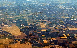
 Farmland of the Central Valley as seen from the air | |
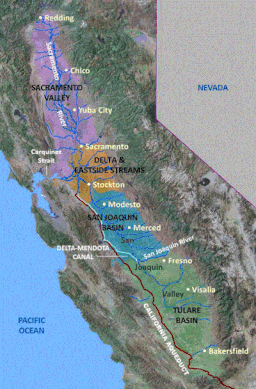
 United States Geological Survey map of their defined four major regions of the Central Valley | |
| Length | 450 mi (720 km) |
| Width | 40 to 60 mi (64 to 97 km) |
| Area | 18,000 sq mi (47,000 km2)[1] |
| Depth | 2,000 to 6,000 ft (610 to 1,830 m) |
| Geology | |
| Type | Alluvial |
| Age | 2–3 million years |
| Geography | |
| Location | California, United States |
| Population centers | Sacramento, Fresno, Bakersfield, Stockton and Modesto |
| Borders on | Sierra Nevada (east), Cascade Range, Klamath Mountains (north), Coast Range, San Francisco Bay (west) and Tehachapi Mountains (south) |
| Coordinates | 37°00′N 120°18′W / 37°N 120.3°W[2] |
| Traversed by | Interstate 5, Interstate 80 and State Route 99 |
| Rivers | Sacramento River, San Joaquin River and Kings River |
The Central Valley is a broad, elongated, flat valley that dominates the interior of California. It is 40–60 mi (60–100 km) wide and runs approximately 450 mi (720 km) from north-northwest to south-southeast, inland from and parallel to the Pacific coast of the state. It covers approximately 18,000 sq mi (47,000 km2),[1] about 11% of California's land area. The valley is bounded by the Coast Ranges to the west and the Sierra Nevada to the east.
The Central Valley is a region known for its agricultural productivity: it provides more than half of the fruits, vegetables, and nuts grown in the United States.[3] More than 7,000,000 acres (28,000 km2) of the valley are irrigated via reservoirs and canals.[4] The valley hosts many cities, including the state capital Sacramento, as well as Redding, Chico, Stockton, Modesto, Merced, Fresno, Visalia, and Bakersfield.
The Central Valley watershed comprises 60,000 square miles (160,000 km2), or over a third of California. It consists of three main drainage systems: the Sacramento Valley in the north, which receives over 20 inches (510 mm) of rain annually; the drier San Joaquin Valley in the south, and the Tulare Basin and its semi-arid desert climate at the southernmost end. The Sacramento and San Joaquin river systems drain their respective valleys and meet to form the Sacramento–San Joaquin River Delta, a large expanse of interconnected canals, stream beds, sloughs, marshes and peat islands. The delta empties into the San Francisco Bay, and ultimately into the Pacific.[5] The waters of the Tulare Basin essentially never reach the ocean (with the exception of Kings River waters diverted northward for irrigation), though they are connected by man-made canals to the San Joaquin.
The valley encompasses all or parts of 18 California counties: Butte, Colusa, Glenn, Fresno, Kern, Kings, Madera, Merced, Placer, San Joaquin, Sacramento, Shasta, Stanislaus, Sutter, Tehama, Tulare, Yolo and Yuba.[6]
Name
Older names include "the Great Valley", a name still often seen in scientific references (notably Great Valley Sequence), as well as "Golden Empire", a booster name that is still referred to by some organizations (notably Golden Empire Transit, Golden Empire Council).[citation needed]
Population

Subregions and their counties commonly associated with the valley include:[6]
- North Sacramento Valley (all or parts of Shasta, Tehama, Glenn, Butte and Colusa counties)
- Sacramento Metropolitan area (all or parts of Sacramento, El Dorado, Sutter, Yuba, Yolo and Placer counties)
- North San Joaquin (all or parts of San Joaquin, Stanislaus and Merced counties)
- South San Joaquin (all or parts of Madera, Fresno, Kings, Tulare and Kern counties)
The four main population centers in the Central Valley area are roughly equidistant from the next. From south to north, they are Bakersfield, Fresno, Sacramento and Redding. These four cities act as hubs for regional commerce and transportation.
The table displays the counties of Central Valley and their respective population during the 2020 US Decennial Census. Total jobs for each county is from the U.S. Census Bureau, OnTheMap Application and LEHD Origin-Destination Employment Statistics (Beginning of Quarter Employment, 2nd Quarter of 2002–2020).
| County | Population | Jobs |
| Butte County | 211,632 | 73,219 |
| Colusa County | 21,839 | 7,834 |
| Fresno County | 1,008,654 | 374,478 |
| Glenn County | 28,917 | 9,314 |
| Kern County | 909,235 | 282,227 |
| Kings County | 152,486 | 43,542 |
| Madera County | 156,255 | 49,285 |
| Merced County | 281,202 | 74,470 |
| Placer County | 404,739 | 166,372 |
| Sacramento County | 1,585,055 | 669,429 |
| San Joaquin County | 779,233 | 247,406 |
| Shasta County | 182,155 | 61,665 |
| Stanislaus County | 552,878 | 184,916 |
| Sutter County | 99,633 | 29,951 |
| Tehama County | 65,829 | 17,735 |
| Tulare County | 473,117 | 157,971 |
| Yolo County | 216,403 | 106,643 |
| Yuba County | 81,575 | 16,937 |
Metropolitan areas
As of 2020, some 7.2 million people lived in the Central Valley; it was the fastest-growing region in California.[7] It includes 12 Metropolitan Statistical Areas (MSA) and 1 Micropolitan Statistical Area (μSA). Below, they are listed by MSA and μSA population. The largest city is Fresno followed by the state capital Sacramento. The following metropolitan and micropolitan statistical areas are listed from largest to smallest:
| SMSA | Population |
|---|---|
| Sacramento Metropolitan Area | 2,527,123 |
| Fresno Metropolitan Area | 930,450 |
| Bakersfield Metropolitan Area | 839,361 |
| Stockton Metropolitan Area | 696,214 |
| Modesto Metropolitan Area | 518,522 |
| Visalia–Porterville Metropolitan Area | 449,253 |
| Merced Metropolitan Area | 259,898 |
| Chico Metropolitan Area | 220,266 |
| Redding Metropolitan Area | 177,774 |
| Yuba City Metropolitan Area | 167,497 |
| Hanford–Corcoran Metropolitan Area | 153,765 |
| Madera Metropolitan Area | 152,925 |
| Red Bluff Micropolitan Area | 63,601 |
Ethnography
After English and Spanish, Punjabi is the third most commonly spoken language in the Central Valley.[8] The valley has the largest Sikh population in the nation.
Geography

The flatness of the valley floor contrasts with the rugged hills or gentle mountains that are typical of most of California's terrain. The valley is thought to have originated below sea level as an offshore area depressed by subduction of the Farallon Plate into a trench farther offshore. The valley has no earthquake faults of its own but is surrounded by faults to the east and west.

The valley was enclosed by the uplift of the Coast Ranges, with its original outlet into Monterey Bay. Faulting moved the Coast Ranges, and a new outlet developed near what is now San Francisco Bay. Over the millennia, the valley filled with the sediments of these same ranges, as well as the rising Sierra Nevada to the east; that filling eventually created an extraordinary flatness just barely above sea level. Before California's flood control and aqueduct system was built, annual snow melt turned much of the valley into an inland sea.
The one notable exception to the flat valley floor is Sutter Buttes, the remnants of an extinct volcano just to the northwest of Yuba City.
Another significant geologic feature of the Central Valley lies hidden beneath the delta. The Stockton Arch is an upwarping of the crust beneath the valley sediments that extends southwest to northeast across the valley.
The Central Valley lies within the California Trough physiographic section, which is part of the larger Pacific Border province, which in turn is part of the Pacific Mountain System.[9][10]
Environment

The Central Valley was formerly a diverse expanse of grassland, containing areas of prairie, desert grassland (at the southern end), oak savanna, riparian forest, marsh, several types of seasonal vernal pools, and large lakes such as now-dry Tulare Lake (once the largest freshwater lake west of the Mississippi), Buena Vista Lake and Kern Lake. However, much of the Central Valley environment has been altered by human activity, including the introduction of exotic plants, notably grasses. The valley's grasslands, wetlands, and riparian forests constitute the California Central Valley grasslands, a temperate grasslands, savannas, and shrublands ecoregion. The foothill oak woodlands and chaparral that fringe the valley have been categorized as the California interior chaparral and woodlands ecoregion.[11]
Flora
The dominant grass of the valley was Nassella pulchra mixed with other species, but today only 1% of the grassland in the valley is intact. Grassland flowers include California poppy (Eschscholzia californica), lupins, and purple owl's clover (Castilleja exserta), which can still be seen, especially in Antelope Valley in the Tehachapi Mountains. Riverside trees include willows, western sycamore (Platanus racemosa), box elder (Acer negundo), Fremont cottonwood (Populus fremontii), and the endemic valley oak (Quercus lobata).
Fauna

The Central Valley was once home to large populations of pronghorn antelope (Antilocapra americana), elk including the endemic tule elk subspecies (Cervus elaphus nannodes), mule deer (Odocoileus hemionus), California ground squirrels, gophers, mice, hare, rabbits and kangaroo rats, along with their predators including the San Joaquin kit fox (an endangered subspecies surviving on the San Joaquin Valley's hillsides). The valley's wetlands were an important habitat for wintering waterbirds and migrating birds of other kinds. Reptiles and amphibians of the valley include the endemic San Joaquin coachwhip snake (Masticophis flagellum ruddocki), blunt-nosed leopard lizard (Gambelia sila), Gilbert's skink (Eumeces gilberti) and the western aquatic garter snake (Thamnophis couchii). Endemic invertebrates are present. The Central Valley is home to endemic fish species, including the Sacramento Pikeminnow, Sacramento Perch, Sacramento Blackfish, and Sacramento Splittail.
Protected areas
The Great Valley Grasslands State Park preserves an example of the valley's native grass habitat, while oak savanna habitats survive near Visalia. Areas of wetland and riverside woodland are found in the north, especially by the Sacramento River system, including the Nature Conservancy's Cosumnes River Preserve just south of Sacramento, Gray Lodge Wildlife Area, Butte Sink Wildlife Management Area, and other patches in the delta area. Remaining vernal pools include Pixley National Wildlife Refuge between Tulare, California, and Bakersfield and Jepson Prairie Preserve in the delta. Large blocks of desert scrubland exist in the southern San Joaquin Valley and the Carrizo Plain, just outside the valley, but offering a similar landscape.
The wetlands have been the target of rescue operations to restore areas replaced by agriculture.[12]
These patches of natural habitat are disconnected, which is particularly damaging for wildlife that is used to migrating along the rivers. Agriculture, grazing land, and the draining of lakes and rivers have radically altered valley habitats. Most of the grassland has been overtaken by new species; most vernal pools have been destroyed, leaving only those on the higher slopes; the marshland has been drained, and the riverbank woodlands have nearly all been affected.[citation needed]
Health
The valley gives its name to Valley fever, which is primarily a disease of the lungs that is common in the southwestern United States and northwestern Mexico. It is caused by the fungus Coccidioides immitis, which grows in soils in areas of low rainfall, high summer temperatures, and moderate winter temperatures. These fungal spores become airborne when the soil is disturbed by winds, construction, or farming. This illness frequently takes weeks or months to resolve. Occasionally Valley Fever is life-threatening or even fatal.
Due to the agricultural industry's significant presence in the Valley, pesticide drift and leaching have become concerns. Residents risk contamination when living in proximity to application sites.
Air pollution
Air pollution is a growing problem that affects all of the citizens in the Central Valley. Some reasons of poor air pollution in the Central Valley are due to agriculture and its geographical features.
Since the Central Valley consists mostly of farming land, a wide, flat valley, the emissions from the soil that is used for growing produce are released into the air. The soil exudes nitrous oxide, an odorless and colorless gas that can be harmful when exposed to it for a long period of time, and incorporates itself into the ozone layer located at ground level.[13] Production of nitrous oxide in California has shown that the addition of soil and fertilization can emit about 161,100 metric tons per year. Long term effects that nitrous oxide can have on a human being is loss of blood pressure, fainting, anemia, or lung cancer.
The physical geographical attributes can also contribute to the air pollution quality. The Central Valley is surrounded by mountain ranges which can capture the pollution coming from the agricultural farming, preventing it from dispersing from the other areas in California.[14]
The Central Valley is also expanding in the number of people that coincide in that area, so it increases the number of cars which can also contribute to the amount of emission that is in the air.
Climate

The northern Central Valley has a hot Mediterranean climate (Köppen climate classification Csa); the more southerly parts in rainshadow zones are dry enough to be Mediterranean steppe (BShs, as around Fresno) or even low-latitude desert (BWh, as in areas around Bakersfield). It is very hot and dry during the summer and cool and damp in winter when frequent ground fog known regionally as "tule fog" can obscure vision. Summer daytime temperatures frequently surpass 100 °F (38 °C), and common heat waves might bring temperatures exceeding 115 °F (46 °C). Mid-autumn to mid-spring is the rainy season—although during the late summer, southeasterly winds can bring tropical thunderstorms, mainly in the southern half of the San Joaquin Valley but occasionally to the Sacramento Valley. The northern half of the Central Valley receives greater precipitation than the semidesert southern half. Frost occurs at times in the fall months, but snow is extremely rare.[16]
Tule fog

Tule fog /ˈtuːliː/ is a thick ground fog that settles along the valley's length. Tule fog forms during the late fall and winter (California's rainy season), after the first significant rainfall. The official season is from November 1 to March 31. This phenomenon is named after the valley's tule grass wetlands (tulares). Auto collisions caused by the tule fog are the leading cause of weather-related casualties in California.
Statistics for selected cities
| Climate data for Sacramento, California (Sacramento Executive Airport), 1991–2020 normals, extremes 1941–present[a] | |||||||||||||
|---|---|---|---|---|---|---|---|---|---|---|---|---|---|
| Month | Jan | Feb | Mar | Apr | May | Jun | Jul | Aug | Sep | Oct | Nov | Dec | Year |
| Record high °F (°C) | 76 (24) |
78 (26) |
88 (31) |
95 (35) |
105 (41) |
115 (46) |
114 (46) |
112 (44) |
114 (46) |
104 (40) |
87 (31) |
74 (23) |
115 (46) |
| Mean maximum °F (°C) | 65.2 (18.4) |
71.1 (21.7) |
78.1 (25.6) |
87.4 (30.8) |
95.3 (35.2) |
103.1 (39.5) |
105.3 (40.7) |
104.1 (40.1) |
100.6 (38.1) |
91.8 (33.2) |
76.5 (24.7) |
65.1 (18.4) |
107.0 (41.7) |
| Mean daily maximum °F (°C) | 56.0 (13.3) |
61.3 (16.3) |
66.3 (19.1) |
72.1 (22.3) |
80.3 (26.8) |
87.9 (31.1) |
92.6 (33.7) |
91.9 (33.3) |
88.5 (31.4) |
78.8 (26.0) |
65.0 (18.3) |
56.0 (13.3) |
74.7 (23.7) |
| Daily mean °F (°C) | 47.6 (8.7) |
51.4 (10.8) |
55.4 (13.0) |
59.5 (15.3) |
66.1 (18.9) |
72.2 (22.3) |
75.9 (24.4) |
75.3 (24.1) |
72.5 (22.5) |
64.5 (18.1) |
53.9 (12.2) |
47.3 (8.5) |
61.8 (16.6) |
| Mean daily minimum °F (°C) | 39.2 (4.0) |
41.5 (5.3) |
44.5 (6.9) |
47.0 (8.3) |
52.0 (11.1) |
56.5 (13.6) |
59.2 (15.1) |
58.8 (14.9) |
56.5 (13.6) |
50.3 (10.2) |
42.7 (5.9) |
38.5 (3.6) |
48.9 (9.4) |
| Mean minimum °F (°C) | 29.1 (−1.6) |
31.7 (−0.2) |
35.1 (1.7) |
37.9 (3.3) |
44.1 (6.7) |
49.5 (9.7) |
54.1 (12.3) |
53.8 (12.1) |
49.6 (9.8) |
41.7 (5.4) |
32.7 (0.4) |
28.7 (−1.8) |
26.9 (−2.8) |
| Record low °F (°C) | 20 (−7) |
23 (−5) |
26 (−3) |
31 (−1) |
34 (1) |
41 (5) |
48 (9) |
48 (9) |
42 (6) |
35 (2) |
26 (−3) |
18 (−8) |
18 (−8) |
| Average precipitation inches (mm) | 3.66 (93) |
3.49 (89) |
2.68 (68) |
1.26 (32) |
0.75 (19) |
0.23 (5.8) |
0.00 (0.00) |
0.04 (1.0) |
0.09 (2.3) |
0.85 (22) |
1.66 (42) |
3.43 (87) |
18.14 (461) |
| Average precipitation days (≥ 0.01 in) | 10.0 | 9.1 | 9.0 | 5.1 | 3.6 | 1.1 | 0.1 | 0.2 | 0.7 | 3.1 | 6.1 | 9.6 | 57.7 |
| Average relative humidity (%) | 83.3 | 76.8 | 71.6 | 64.5
Zdroj:https://en.wikipedia.org?pojem=Central_Valley_(California) Text je dostupný za podmienok Creative Commons Attribution/Share-Alike License 3.0 Unported; prípadne za ďalších podmienok. Podrobnejšie informácie nájdete na stránke Podmienky použitia.
Analytika
Antropológia Aplikované vedy Bibliometria Dejiny vedy Encyklopédie Filozofia vedy Forenzné vedy Humanitné vedy Knižničná veda Kryogenika Kryptológia Kulturológia Literárna veda Medzidisciplinárne oblasti Metódy kvantitatívnej analýzy Metavedy Metodika Text je dostupný za podmienok Creative
Commons Attribution/Share-Alike License 3.0 Unported; prípadne za ďalších
podmienok. www.astronomia.sk | www.biologia.sk | www.botanika.sk | www.dejiny.sk | www.economy.sk | www.elektrotechnika.sk | www.estetika.sk | www.farmakologia.sk | www.filozofia.sk | Fyzika | www.futurologia.sk | www.genetika.sk | www.chemia.sk | www.lingvistika.sk | www.politologia.sk | www.psychologia.sk | www.sexuologia.sk | www.sociologia.sk | www.veda.sk I www.zoologia.sk | |||||||||
