A | B | C | D | E | F | G | H | CH | I | J | K | L | M | N | O | P | Q | R | S | T | U | V | W | X | Y | Z | 0 | 1 | 2 | 3 | 4 | 5 | 6 | 7 | 8 | 9
Monterey County, California | |
|---|---|
| County of Monterey | |
|
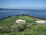
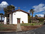
Images, from top down, left to right: Monterey Bay Aquarium, Main Street in Salinas, the seventh hole at Pebble Beach Golf Links, Mission Soledad, Big Sur Coastline | |
 Interactive map of Monterey County | |
 Location in the state of California | |
| Country | United States |
| State | California |
| Incorporated | February 18, 1850[1] |
| Named for | Monterey Bay |
| County seat | Salinas |
| Largest city | Salinas |
| Government | |
| • Type | Council–CAO |
| • Body | Board of Supervisors |
| • Chair | Luis Alejo |
| • Vice Chair | Glenn Church |
| • Board of Supervisors[2] | Supervisors
|
| • County Administrative Office | Sonia M. De La Rosa |
| Area | |
| • Total | 3,771 sq mi (9,770 km2) |
| • Land | 3,281 sq mi (8,500 km2) |
| • Water | 491 sq mi (1,270 km2) |
| Highest elevation | 5,865 ft (1,788 m) |
| Population (2020) | |
| • Total | 439,035 |
| • Density | 134/sq mi (52/km2) |
| Time zone | UTC-8 (Pacific Time Zone) |
| • Summer (DST) | UTC-7 (Pacific Daylight Time) |
| Area codes | 805, 831 |
| Congressional districts | 18th, 19th |
| Website | countyofmonterey |
Monterey County (/ˌmɒntəˈreɪ/ ⓘ MON-tə-RAY), officially the County of Monterey, is a county located on the Pacific coast in the U.S. state of California. As of the 2020 census, its population was 439,035.[4] The county's largest city and county seat is Salinas.[5]
Monterey County comprises the Salinas, California, Metropolitan Statistical Area. It borders on the southern part of Monterey Bay, after which it is named. (The northern half of the bay is in Santa Cruz County.) Monterey County is a member of the regional governmental agency: the Association of Monterey Bay Area Governments.
Scenic features along the coastline - including Carmel-by-the-Sea, Big Sur, State Route 1, and the 17 Mile Drive on the Monterey Peninsula - have made the county famous around the world. Back when California was under Spanish and Mexican rule, the city of Monterey was its capital. Today, the economy of the county is mostly based on tourism in its coastal regions, and on agriculture in the region of the Salinas River valley. Most of the county's inhabitants live near the northern coast or in Salinas Valley; the southern coast and inland mountainous regions are sparsely populated.
History

Monterey County was one of the original counties of California, created in 1850 at the time of statehood. Parts of the county were given to San Benito County in 1874. The area was originally populated by Ohlone, Salinan and the Esselen tribes.
The county derives its name from Monterey Bay. The bay was named by Sebastián Vizcaíno in 1602 in honor of the Conde de Monterrey (or Count of Monterrey), then the Viceroy of New Spain.[6] Monterrey is a variation of Monterrei, a municipality in the Galicia region of Spain where the Conde de Monterrey and his father (the Fourth Count of Monterrei) were from.
Geography
According to the U.S. Census Bureau, the county has a total area of 3,771 square miles (9,770 km2), of which 3,281 square miles (8,500 km2) is land and 491 square miles (1,270 km2) (13%) is water.[7] The county is roughly 1.5 times larger than the state of Delaware, and roughly similar in population and the size to Santa Barbara County.
Adjacent counties
Santa Cruz County to the north, San Benito County, Fresno County, and Kings County to the east as well as San Luis Obispo County to the south.
National protected areas
- Los Padres National Forest (part)
- Pinnacles National Park (part)
- Salinas River National Wildlife Refuge
- Ventana Wilderness (part)
In October 2019, the Bureau of Land Management ended a five-year moratorium on leasing federal land in California to fossil fuel companies, opening 725,000 acres (1100 sq. miles; 29,000 ha) to drilling in San Benito, Monterey, and Fresno counties.[8]
Marine protected areas
- Soquel Canyon State Marine Conservation Area
- Elkhorn Slough State Marine Reserve
- Elkhorn Slough State Marine Conservation Area
- Moro Cojo Slough State Marine Reserve
- Portuguese Ledge State Marine Conservation Area
- Pacific Grove Marine Gardens State Marine Conservation Area
- Lovers Point State Marine Reserve
- Edward F. Ricketts State Marine Conservation Area
- Asilomar State Marine Reserve
Flora and fauna
Monterey County has habitat to support the following endangered species:
- Hickman's potentilla
- Santa Cruz Long-toed Salamander
- Santa Cruz Tarweed
- Southern Steelhead Trout
- Yadon's piperia
Demographics
| Census | Pop. | Note | %± |
|---|---|---|---|
| 1850 | 1,872 | — | |
| 1860 | 4,739 | 153.2% | |
| 1870 | 9,876 | 108.4% | |
| 1880 | 11,302 | 14.4% | |
| 1890 | 18,637 | 64.9% | |
| 1900 | 19,380 | 4.0% | |
| 1910 | 24,146 | 24.6% | |
| 1920 | 27,980 | 15.9% | |
| 1930 | 53,705 | 91.9% | |
| 1940 | 73,032 | 36.0% | |
| 1950 | 130,498 | 78.7% | |
| 1960 | 198,351 | 52.0% | |
| 1970 | 250,071 | 26.1% | |
| 1980 | 290,444 | 16.1% | |
| 1990 | 355,660 | 22.5% | |
| 2000 | 401,762 | 13.0% | |
| 2010 | 415,057 | 3.3% | |
| 2020 | 439,035 | 5.8% | |
| 2023 (est.) | 430,723 | [9] | −1.9% |
| U.S. Decennial Census[10] 1790–1960[11] 1900–1990[better source needed][12] 1990–2000[13] 2010[14] 2020[15] | |||
2020 census
| Race / Ethnicity | Pop 2010[14] | Pop 2020[15] | % 2010 | % 2020 |
|---|---|---|---|---|
| White alone (NH) | 136,435 | 120,077 | 32.87% | 27.35% |
| Black or African American alone (NH) | 11,300 | 9,051 | 2.72% | 2.06% |
| Native American or Alaska Native alone (NH) | 1,361 | 1,314 | 0.33% | 0.30% |
| Asian alone (NH) | 23,777 | 25,123 | 5.73% | 5.72% |
| Pacific Islander alone (NH) | 1,868 | 1,859 | 0.45% | 0.42% |
| Some Other Race alone (NH) | 741 | 2,170 | 0.18% | 0.49% |
| Mixed Race/Multi-Racial (NH) | 9,572 | 14,120 | 2.31% | 3.22% |
| Hispanic or Latino (any race) | 230,003 | 265,321 | 55.41% | 60.43% |
| Total | 415,057 | 439,035 | 100.00% | 100.00% |
Note: the US Census treats Hispanic/Latino as an ethnic category. This table excludes Latinos from the racial categories and assigns them to a separate category. Hispanics/Latinos can be of any race.
Income, education and poverty 2013


Generally, the western/southern parts of the Monterey Peninsula, Carmel Valley, Creekbridge (Salinas), and eastern parts of Prundale were the county's most affluent and educated (see dark blue on map). These areas had a median household income significantly above that of the California or the U.S. overall (typically above $95,000 vs. $60,000 for California and $52,000 for the U.S.)[17] and comprised roughly 8%-10% of neighborhoods (as defined by Census Block Groups).[18] Educational attainment was at least on part with, or above, state and national levels,[19] in these areas while the percentage of people living in poverty was typically a third or less than national and statewide average (with the exception of South Salinas).[20]
Social deprivation (poverty and low levels of educational attainment) was concentrated in the central and eastern parts of Salinas, and central areas of Monterey, Seaside, Marina, Soledad and King City. In central and eastern Salinas up to 46% of individuals lived below the poverty line and those without a secondary educations formed a plurality or majority of residents.[19][20] Overall, the Salinas metropolitan area, defined as coterminous with Monterey County, was among the least educated urban areas in the nation.
Most affluent neighborhoods
Roughly 8% of neighborhoods, as defined by Census Block Groups, had a median household income above $100,000 per year, about 60% above the national median. This coincided with the top 20 census block groups in the county listed below.[17][18]
Most affluent neighborhoods (Median Household Income above $100k/yr.)[18][21]
| Rank | neighborhood | Census Reference/Geo-Unit | Median Household Income |
|---|---|---|---|
| 1 | Carmel Valley (North-West) | Block Group 1, Census Tract 116.02 | $152,411 |
| 2 | Mount Toro Foothills, Salinas Valley | Block Group 3, Census Tract 107.01 | $143,508 |
| 3 | Jacks Peak, Monterey | Block Group 1, Census Tract 132 | $142,143 |
| 4 | Mount Toro Foothills, Salinas Valley | Block Group 2, Census Tract 107.02 | $141,364 |
| 5 | Skyline Forest, Monterey | Block Group 3, Census Tract 128 | $130,221 |
| 6 | Yankee Point, Carmel | Block Group 3, Census Tract 117 | $126,389 |
| 7 | Carmel Valley (North-West) | Block Group 3, Census Tract 116.02 | $122,056 |
| 8 | Carmel Valley (North-West) | Block Group 4, Census Tract 116.02 | $118,159 |
| 9 | Carmel Valley (North-West) | Block Group 2, Census Tract 110 | $118,125 |
| 10 | Carmel Valley (North-West) | Block Group 4, Census Tract 110 | $115,667 |
| 11 | Carmel (East, outside of city limits) | Block Group 2, Census Tract 117 | $115,357 |
| 12 | Jacks Peak, Monterey | Block Group 2, Census Tract 132 | $113,750 |
| 13 | Skyline Forest, Monterey | Block Group 5, Census Tract 128 | $111,500 |
| 14 | City of Carmel (Southern half) | Block Group 1, Census Tract 118.02 | $110,962 |
| 15 | Las Palmas, Salinas Valley | Block Group 2, Census Tract 107.01 | $110,918 |
| 16 | Pebble Beach, Monterey Peninsula Country Club | Block Group 4, Census Tract 119 | $107,500 |
| 17 | Mount Toro Foothills, Salinas Valley | Block Group 1, Census Tract 107.02 | $105,511 |
| 18 | Carmel Valley (North-West) | Block Group 1, Census Tract 116.04 | $104,902 |
| 19 | City of Carmel (Northern half) | Block Group 2, Census Tract 118.01 | $101,984 |
| 20 | Creekbridge (incl. Falcon Meadows), Salinas | Block Group 2, Census Tract 106.03 | $100,673 |
| 141* | United States | N/A | $53,046 |
| 104* | California | N/A | $61,094 |
| 154* | City of Salinas | N/A | $49,264 |
* Asterisk denotes a hypothetical rank among Monterey County's 226 Census Block Groups (e.g. if the U.S. overall was a Census Block Group in Monterey County, it would be the 141st most affluent of 226).
Least affluent neighborhoods
About 4.5% of neighborhoods, as defined by Census Block Groups, had a median household income below $30,000 per year, about 60% below the national median. This coincided with the 10 poorest of the 20 lowest income neighborhoods listed in the table below.[17][18]
Least affluent neighborhoods (Median Household Income of $34.1k or less)[18][21]


