A | B | C | D | E | F | G | H | CH | I | J | K | L | M | N | O | P | Q | R | S | T | U | V | W | X | Y | Z | 0 | 1 | 2 | 3 | 4 | 5 | 6 | 7 | 8 | 9
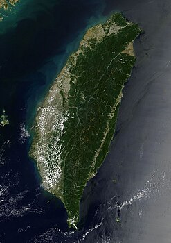
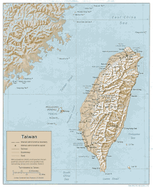
 Taiwan is mostly mountainous in the east, with gently sloping plains in the west. The Penghu Islands appear in the Taiwan Strait to the west of the main island. | |
 | |
| Region | East Asia |
|---|---|
| Area | Ranked 138 |
| • Total | 36,197 km2 (13,976 sq mi) |
| • Land | 89.7% |
| • Water | 10.3% |
| Coastline | 1,566.3 km (973.3 mi) |
| Highest point | Yu Shan, 3,952 m (12,966 ft) |
| Climate | Tropical marine[1] |
| Natural resources | Small deposits of coal, natural gas, limestone, marble, asbestos, arable land[1], rice |
| Environmental issues | Air pollution, water pollution from industrial emissions and raw sewage, contamination of drinking water, trade in endangered species, low-level radioactive waste disposal[1] |
| Exclusive economic zone | 83,231 km2 (32,136 sq mi) |
| Taiwan | |||||||||||||||||||||||||||||||||||||||||||
|---|---|---|---|---|---|---|---|---|---|---|---|---|---|---|---|---|---|---|---|---|---|---|---|---|---|---|---|---|---|---|---|---|---|---|---|---|---|---|---|---|---|---|---|
 | |||||||||||||||||||||||||||||||||||||||||||
| Traditional Chinese | 臺灣 or 台灣 | ||||||||||||||||||||||||||||||||||||||||||
| Simplified Chinese | 台湾 | ||||||||||||||||||||||||||||||||||||||||||
| Postal | Taiwan | ||||||||||||||||||||||||||||||||||||||||||
| |||||||||||||||||||||||||||||||||||||||||||
Taiwan, officially the Republic of China (ROC), is an island country in East Asia. The island of Taiwan, formerly known as Formosa, makes up 99% of the land area of the territories under ROC control. The main island is 35,808 square kilometres (13,826 sq mi) and lies some 180 kilometres (112 mi) across the Taiwan Strait from the southeastern coast of the People's Republic of China (PRC). The East China Sea lies to the north of the island, the Philippine Sea to its east, the Luzon Strait directly to its south and the South China Sea to its southwest. The ROC also controls a number of smaller islands, including the Penghu archipelago in the Taiwan Strait, the Kinmen and Matsu Islands in Fuchien near the PRC's coast, and some of the South China Sea Islands.
Geologically, the main island comprises a tilted fault block, characterized by the contrast between the eastern two-thirds, consisting mostly of five rugged mountain ranges running parallel to the east coast, and the flat to gently rolling plains of the western third, where the majority of the population resides. Several peaks exceed 3,500 m in height - the highest, Yu Shan at 3,952 m (12,966 ft), makes Taiwan the world's fourth-highest island. The tectonic boundary that formed these ranges remains active, and the island experiences many earthquakes, some of them highly destructive. There are also many[quantify] active submarine volcanoes in the Taiwan Straits.
The climate ranges from tropical in the south to subtropical in the north, and is governed by the East Asian Monsoon. On average, four typhoons strike the main island each year. The heavily forested eastern mountains provide a habitat for a diverse range of wildlife, while human land use in the western and northern lowlands is intensive.
Physical boundaries
The total land area of Taiwan is 36,197 km2 (13,976 sq mi),[2] slightly larger than Belgium. It has a coastline of 1,566.3 km (973.3 mi).[1] The ROC claims an exclusive economic zone of 83,231 km2 (32,136 sq mi) with 200 nmi (370.4 km; 230.2 mi) and a territorial sea of 12 nmi (22.2 km; 13.8 mi).[1][3]
Taiwan proper, the main island of the archipelago, was known in the West until after World War II as Formosa, from the Portuguese Ilha Formosa ([ˌiʎɐ fuɾˈmɔzɐ]), "beautiful island".[4] It is 394 km (245 mi) long and 144 km (89 mi) wide,[5] and has an area of 35,808 km2 (13,826 sq mi).[6] The northernmost point of the island is Cape Fugui in New Taipei's Shimen District. The central point of the island is in Puli Township, Nantou County. The southernmost point on the island is Cape Eluanbi in Hengchun Township, Pingtung County.
The island of Taiwan is separated from the southeast coast of mainland China by the Taiwan Strait, which ranges from 220 km (140 mi) at its widest point to 130 km (81 mi) at its narrowest. Part of the continental shelf, the Strait is no more than 100 m (330 ft) deep, and has become a land bridge during glacial periods.[7]
To the south, the island of Taiwan is separated from the Philippine island of Luzon by the 250 km (155 mi)-wide Luzon Strait. The South China Sea lies to the southwest, the East China Sea to the north, and the Philippine Sea to the east.[8] Niushan Island in Nanlai village, Aoqian town, Pingtan County, Fuzhou, Fujian is the closest China (PRC)-administered island to Taiwan (main island).[9]
Smaller islands of the archipelago include the Penghu islands in the Taiwan Strait 50 km (31 mi) west of the main island, with an area of 127 km2 (49 sq mi), the tiny islet of Xiaoliuqiu off the southwest coast, and Orchid Island and Green Island to the southeast, separated from the northernmost islands of the Philippines by the Bashi Channel. The islands of Kinmen and Matsu near the coast of Fujian across the Taiwan Strait have a total area of 180 km2 (69 sq mi);[10] the Pratas and Taiping islets in the South China Sea are also administered by the ROC, but are not part of the Taiwanese archipelago.[11][12]
Geology

The island of Taiwan was formed approximately 4 to 5 million years ago at a complex convergent boundary between the Philippine Sea Plate and the Eurasian Plate. In a boundary running the length of the island and continuing southwards in the Luzon Volcanic Arc (including Green Island and Orchid Island), the Eurasian Plate is sliding under the Philippine Sea Plate.
Most of the island comprises a huge fault block tilted to the west.[13] The western part of the island, and much of the central range, consists of sedimentary deposits scraped from the descending edge of the Eurasian Plate. In the northeast of the island, and continuing eastwards in the Ryukyu Volcanic Arc, the Philippine Sea Plate slides under the Eurasian Plate.[14][15]
The tectonic boundary remains active, and Taiwan experiences 15,000 to 18,000 earthquakes each year, of which 800 to 1,000 are noticed by people. The most catastrophic recent earthquake was the magnitude-7.3 Chi-Chi earthquake, which occurred in the centre of Taiwan on 21 September 1999, killing more than 2,400 people.[16] On 4 March 2010 at about 01:20 UTC, a magnitude 6.4 earthquake hit southwestern Taiwan in the mountainous area of Kaohsiung County.[17] Another major earthquake occurred on 6 February 2016, with a magnitude of 6.4. Tainan was damaged the most, with 117 deaths, most of them caused by the collapse of a 17-story apartment building.[18]
Terrain

The terrain in Taiwan is divided into two parts: the flat to gently rolling plains in the west, where 90% of the population lives, and the mostly rugged forest-covered mountains in the eastern two-thirds.
The eastern part of the island is dominated by five mountain ranges, each running from north-northeast to south-southwest, roughly parallel to the east coast of the island. As a group, they extend 330 km (210 mi) from north to south and average about 80 kilometres (50 mi) from east to west. They include more than two hundred peaks with elevations of over 3,000 m (9,800 ft).[6]
The Central Mountain Range extends from Su'ao in the northeast to Eluanbi at the southern tip of the island, forming a ridge of high mountains and serving as the island's principal watershed. The mountains are predominantly composed of hard rock formations resistant to weathering and erosion, although heavy rainfall has deeply scarred the sides with gorges and sharp valleys. The relative relief of the terrain is usually extensive, and the forest-clad mountains with their extreme ruggedness are almost impenetrable. The east side of the Central Mountain Range is the steepest mountain slope in Taiwan, with fault scarps ranging in height from 120 to 1,200 m (390 to 3,900 ft). Taroko National Park, on the steep eastern side of the range, has good examples of mountainous terrain, gorges and erosion caused by a swiftly flowing river.
The East Coast Mountain Range extends down the east coast of the island from the mouth of the Hualien River in the north to Taitung County in the south, and chiefly consist of sandstone and shale. It is separated from the Central Range by the narrow Huatung Valley, at an altitude of 120 m (390 ft). Although Hsinkangshan (新港山), the highest peak, reaches an elevation of 1,682 m (5,518 ft), most of the range is composed of large hills. Small streams have developed on the flanks, but only one large river cuts across the range. Badlands are located at the western foot of the range, where the ground water level is the lowest and rock formations are the least resistant to weathering. Raised coral reefs along the east coast and the frequent occurrences of earthquakes in the rift valley indicate that the fault block is still rising.
The ranges to the west of the Central range are divided into two groups separated by the Sun Moon Lake Basin in the centre of the island. The Dadu and Zhuoshui Rivers flow from the western slopes of the Central Range through the basin to the west coast of the island.
The Xueshan Range lies to the northwest of the Central Mountain Range, beginning at Sandiaojiao, the northeast tip of the island, and gaining elevation as it extends southwest towards Nantou County. Xueshan, the main peak, is 3,886 m (12,749 ft) high.

The Yushan Range runs along the southwestern flank of the Central Range. It includes the island's tallest peak, the 3,952 m (12,966 ft) Yu Shan ('Jade Mountain')[1][19][20] which makes Taiwan the world's fourth-highest island, and is the highest point in the western Pacific region outside of the Kamchatka Peninsula, New Guinea Highlands and Mount Kinabalu.[21]
The Alishan Range lies west of the Yushan Range, across the valley of the south-flowing Kaoping River. The range has major elevations between 1,000 and 2,000 m (3,300 and 6,600 ft). The main peak, Data Mountain (大塔山), towers 2,663 m (8,737 ft).
Below the western foothills of the ranges, such as the Hsinchu Hills and the Miaoli Hills, lie raised terraces formed of material eroded from the ranges. These include the Linkou Plateau, the Taoyuan Plateau and the Dadu Plateau. About 23% of Taiwan's land area consists of fertile alluvial plains and basins watered by rivers running from the eastern mountains. Over half of this land lies in the Chianan Plain in southwest Taiwan, with lesser areas in the Pingtung Plain, Taichung Basin and Taipei Basin. The only sizable plain on the east coast is the Yilan Plain in the northeast.[22]
Climate

The island of Taiwan lies across the Tropic of Cancer, and its climate is influenced by the East Asian Monsoon. Northern Taiwan has a humid subtropical climate, with substantial seasonal variation of temperatures, while parts of central and most of southern Taiwan have a tropical monsoon climate where seasonal temperature variations are less noticeable, with temperatures typically varying from warm to hot. During the winter (November to March), the northeast experiences steady rain, while the central and southern parts of the island are mostly sunny. The summer monsoon (from May to October) accounts for 90% of the annual precipitation in the south, but only 60% in the north.[23] The average rainfall is approximately 2,600 mm per year.[23]
| ||||||||||||||||||||||||||||||||||||||||||||||||||||||||||||||||||||||||||||||||||||||||||||||||||||||||||||||||||||||||||||||||||||||||||||||||||||||||||||||||||||||||||||||||||||||||||||||||||||||||||||||||||||||||||||||||||||||||||||||||||||||||||||||||||||||||||||||||||||||||||||||||||||||||||||||||||||||||
