

A | B | C | D | E | F | G | H | CH | I | J | K | L | M | N | O | P | Q | R | S | T | U | V | W | X | Y | Z | 0 | 1 | 2 | 3 | 4 | 5 | 6 | 7 | 8 | 9
Native name: 沖縄本島 | |
|---|---|
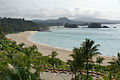
 Okinawa Island in 2015 | |
 Map of the island | |
 Okinawa Island  Okinawa Island | |
| Geography | |
| Location | Pacific Ocean |
| Coordinates | 26°28′46″N 127°55′40″E / 26.47944°N 127.92778°E |
| Archipelago | Ryukyu Islands |
| Area | 1,199[1] km2 (463 sq mi) as of 1 October 2018[2] |
| Area rank | 299th |
| Length | 106.6 km (66.24 mi) |
| Width | 11.3 km (7.02 mi) |
| Highest elevation | 503 m (1650 ft) |
| Highest point | Mount Yonaha |
| Administration | |
| Prefecture | Okinawa Prefecture |
| Demographics | |
| Population | 1,466,870[3] (2022) |
| Pop. density | 1,014.93/km2 (2628.66/sq mi) |
| Ethnic groups | Ryukyuan, Japanese |
Okinawa Island (沖縄島, Okinawa-jima, Okinawan: 沖縄/うちなー, Uchinaa[4] Kunigami: ふちなー, Fuchináa), officially Okinawa Main Island (沖縄本島, Okinawa-hontō),[5] is the largest of the Okinawa Islands and the Ryukyu (Nansei) Islands of Japan in the Kyushu region. It is the smallest and least populated of the five main islands of Japan.[6] The island is approximately 106 kilometres (66 mi) long, an average 11 kilometres (7 mi) wide,[7] and has an area of 1,206.98 square kilometers (466.02 sq mi). It is roughly 640 kilometres (350 nmi; 400 mi) south of the main island of Kyushu and the rest of Japan. It is 500 km (270 nmi; 310 mi) northeast of Taiwan. The total population of Okinawa Island is 1,384,762.[3] The greater Naha area has roughly 800,000 residents, while the city itself has about 320,000 people. Naha is the seat of Okinawa Prefecture on the southwestern part of Okinawa Island. Okinawa has a humid subtropical climate.
Okinawa has been a critical strategic location for the United States Armed Forces since the Battle of Okinawa and the end of World War II. The island was formally controlled by the United States Civil Administration of the Ryukyu Islands until 1972, with around 26,000 U.S. military personnel stationed on Okinawa today, comprising about half of the total complement of the United States Forces Japan, spread among 31 areas, across 13 bases and 48 training sites. United States military installations cover approximately 25% of the island.
History
Shell mound eras
Early Okinawan history is defined by midden or shell heap culture and is divided into Early, Middle, and Late Shell Mound periods. The Early Shell Mound period was a hunter-gatherer society, with the wave-like opening Jōmon pottery. In the latter part of this period, archaeological sites moved near the seashore, suggesting the engagement of people in fishing. On Okinawa, rice was not cultivated until the Middle Shell Mound period. Shell rings for arms made of shells obtained in the Sakishima Islands, namely Miyakojima and Yaeyama islands, were imported by Japan. In these islands, the presence of shell axes from 2,500 years ago suggests the influence of a southeastern-Pacific culture.[8][9]

After the Late Shell Mound period, agriculture started about the 12th century, and the population center moved from the seashore to higher places. This period is called the Gusuku period. Gusuku is a term used for the distinctive Ryukyuan form of castles or fortresses. Many gusukus and related cultural remains in the Ryukyu Islands have been listed by UNESCO as World Heritage Sites. There are three perspectives regarding the nature of gusukus: that they were holy places, dwellings encircled by stones, and castles of the rulers. In this period, porcelain trade between Okinawa and other countries became commonplace, and Okinawa was an important relay point in eastern-Asian trade. Ryukyuan kings, such as Shunten and Eiso, were important rulers. An attempted Mongolian invasion in 1291 during the Eiso Dynasty failed. Hiragana was imported from Japan by Ganjin in 1265. Noro, village priestesses of the Ryukyuan religion, appeared.
Sanzan era and Ryūkyū Kingdom
The Sanzan period began in 1314 when the kingdoms of Hokuzan and Nanzan declared independence from Chūzan. The three kingdoms competed with one another for recognition and trade with Ming China.[10] King Satto, leading Chūzan, was very successful, establishing relations with Korea and Southeast Asia as well as China. The Hongwu Emperor sent 36 families from Fujian in 1392 at the request of the Ryukyuan king. Their job was to manage maritime dealings in the kingdom. They assisted the Ryukyuans in developing their technology and diplomatic relations. In 1407, however, a man named Hashi overthrew Satto's descendant, King Bunei, and installed his father, Shishō, as king of Chūzan.

In 1429, King Shō Hashi completed the unification of the three kingdoms and founded the Ryūkyū Kingdom with its capital at Shuri Castle. His descendants conquered the Amami Islands. In 1469, King Shō Taikyū died, so the royal government chose a man named Kanemaru as the new king, who chose the name Shō En and established the Second Shō Dynasty. His son Shō Shin conquered the Sakishima Islands and centralized the royal government, the military, and the noro priestesses.
Satsuma Domain
In 1609, the Japanese Satsuma Domain launched the invasion of Ryukyu, ultimately capturing the king and his capital after a long struggle. Ryukyu was forced to cede the Amami Islands and become a vassal of Satsuma. The kingdom became both a tributary of China and a tributary of Japan. Because China would not make a formal trade agreement unless a country was a tributary state, the kingdom was a convenient loophole for Japanese trade with China. When Japan officially closed off trade with European nations except for the Dutch, Nagasaki, Tsushima, and Kagoshima became the only Japanese trading ports offering connections with the outside world.
At some time,[when?] karate came into existence as a type of systematized martial arts.
18th and 19th centuries
Several Europeans visited Ryukyu starting in the late 18th century. The most important visits to Okinawa were from Captain Basil Hall in 1816 and Commodore Matthew C. Perry in 1852. A Christian missionary, Bernard Jean Bettelheim, lived in the Gokoku-ji temple in Naha from 1846 to 1854.
In 1879, Japan annexed the entire Ryukyu archipelago.[11] The Meiji government then established Okinawa Prefecture. The monarchy in Shuri was abolished, and the deposed King Shō Tai was forced to relocate to Tokyo.
.jpg)
Hostility against Japan increased in the islands immediately after the annexation, in part because of the systematic attempt on the part of Japan to eliminate Ryukyuan culture, including the language, religion, and cultural practices.
Pacific War
Okinawa Island had the bloodiest ground battle of the Pacific War from 1 April to 22 June 1945. During this 82-day-long battle, about 95,000 Imperial Japanese Army troops and 20,195 Americans were killed. The Cornerstone of Peace at the Peace Memorial Park in Itoman lists 149,193 persons from Okinawa – approximately one quarter of the civilian population – were either killed or committed suicide during the Battle of Okinawa and the Pacific War.[12] Very few Japanese ended up in POW camps. This may have been because of Japanese soldiers' reluctance to surrender. The total number of casualties shocked American military strategists. This made them apprehensive to invade the other main islands of Japan, because it would result in very high casualties.[13][14]
American occupation
Japan became a pacifist country with the 1947 constitution, so America was obligated to protect Japan against foreign threats. During the American military occupation of Japan (1945–1952), which followed the Imperial Japanese surrender on 2 September 1945, in Tokyo Bay, the United States controlled Okinawa Island and the rest of the Ryukyu Islands. The Amami Islands were returned to Japanese control in 1953. The remaining Ryukyu Islands were returned to Japan on 17 June 1971. America kept numerous U.S. military bases on the islands. There are 32 United States military bases on Okinawa Island[15] by the U.S.-Japan alliance since 1951. U.S. bases on Okinawa played critical roles in the Korean War, Vietnam War, Laotian Civil War, Cambodian campaign, War in Afghanistan, and Iraq War.[16] Okinawa served as a prime staging post for the aforementioned wars.[16] Its ports and airports were used to transport supplies. The base at Camp Chinen, Nanjo City was used by the CIA for covert operations. In 1965, Admiral Ulysses S. Grant Sharp stated that "Without Okinawa, we couldn't continue fighting the Vietnam war."[16]
Intense use of the island by the U.S. military caused damage to the environment and residents.[16] There were oil and fuel spills.[16] Exposure to toxic substances caused illness of service members such as a nerve agent leak in 1969.[16] Aircraft crashes, hit-and runs and murders killed residents.[16] The perpetrators were often unpunished, since they could not be prosecuted in Okinawa Courts.[16] The 1970s and 1980s also had severe pollution of waterways and wells with PFAS: toxic chemicals in foam used by fire fighting training at U.S. facilities such as Kadena Air Base.[17]
1970s narcotics trade
In the early 1970s, according to a U.S. government report, Okinawa was a key conduit for smuggling drugs such as heroin from Thailand via Okinawa to the United States.[16] It was called "The Okinawa System" in the global drug trade.[16] A testimony by a head of the Department of Defense said that drug abuse was "quite extensive."[16] It began in the second half of 1968; marijuana was smuggled from Thailand to Okinawa and grown near an unidentified U.S. Marine Corps training area in northern Okinawa.[16] A 100 kg (220 lb) package of marijuana fell from an aircraft, and another 90 kg (200 lb) was discovered at a military post office.[16] From the mid-1970s onwards, LSD and heroin became more prevalent.[16] Deserters worked as "passport civilians" and smuggled the drugs into Okinawa.[16] A lack of customs inspections made smuggling easy.[16] There were well organized Ryukyuan smuggling rings who brought heroin, LSD, and marijuana to Okinawa, and produced LSD on the island.[16]
21st century
In 2013, following escalating tensions following competing claims to the uninhabited Senkaku Islands, the People's Republic of China began questioning Japan's sovereignty to the island of Okinawa, citing its past as the independent tributary state of Ryukyu.[18][19] On 31 October 2019, the main courtyard structures of Shurijo were destroyed in a fire.[20] It marked the fifth time that Shurijo was destroyed following previous incidents in 1453, 1660, 1709 and 1945.[21]
On 31 October 2019, a large fire burned down sections of Shuri Castle: "Six castle buildings occupying some 4,200 square metres (45,000 sq ft) in total were gutted."[22][23][20] Rebuilding efforts were underway as of 10 February 2020.[24]
Demographics

As of September 2009, the Japanese government estimates the population at 1,384,762,[3] which includes American military personnel and their families. The Okinawan language, called Uchināguchi, is spoken by adults only,[25] but several local groups promote the use of the Okinawan language by younger people.[26]
Whereas the northern half of Okinawa Island is sparsely populated, the south-central and southern parts of the island are markedly urbanized—particularly the city of Naha and the urban corridor stretching north from there to Okinawa City. The population distribution is approximately 120,000 in northern Okinawa, 590,000 in central Okinawa and 540,000 in southern Okinawa. It has a high population density of 1,014.93/km2.[27]
During the Meiji Period, Okinawan ethnic identity, tradition, culture and language were suppressed by the Meiji government, which sought to assimilate the Okinawans as Japanese (Yamato).[28][29][30][31][32][33] Many ethnic Japanese have since migrated to Okinawa. The modern inhabitants of Okinawa are mainly ethnic Okinawan, Japanese, half Japanese and mixed.
Okinawans are known for their longevity. This particular island is a so-called Blue Zone, an area where the people live longer than most others elsewhere in the world.[34] Five times as many Okinawans reach 100 years old compared to the rest of Japan. As of 2002[update] there were 34.7 centenarians for every 100,000 inhabitants, which is the highest ratio worldwide.[35]: 131–132 Possible explanations are diet, low-stress lifestyle, caring community, activity, and spirituality of the inhabitants of the island.[35][page needed] The Okinawan diet consists of low-fat, low-salt foods, such as whole fruits and vegetables, legumes, tofu, and seaweed.
Geography

Okinawa is the fifth largest island of Japan. The island has an area of 1,206.99 square kilometers (466.02 sq mi). The coastline is 476 kilometers (296 mi) long.[36] The straight-line distance is about 106.6 kilometers (66.2 mi) from north to south.[37] Okinawa is in the northeastern end of Okinawa Prefecture. Since 1972 over 1,000 hectares (2,500 acres) of land reclamation has been conducted.
It is roughly 640 kilometres (400 mi) south of the main island of Kyushu. Okinawa is connected to nearby islands near a land bridge: Katsuren Peninsula is connected via the Mid-Sea Road to Henza Island, Miyagi Island, Ikei Island, and Hamahiga Island. Similarly, from the Motobu Peninsula on the northwestern side, all of Sesoko-jima plus Yagaji Island and Kōri-jima are connected by bridges. Okinawa Island has several beaches such as Manza Beach, Emerald Beach, Okuma Beach, Zanpa Beach, Moon Beach and Sunset Beach (Chatan-cho). Mount Omoto, at 525.5 m (1,724 ft), is the highest mountain in Okinawa, with Mount Yonaha being the second highest.[38]
The Motobu Peninsula in the north has limestone layers and karst development.[39] In the center and south is mainly a Ryukyu limestone layer and mudstone.[39] The topography is flat, there are few hills over 100 m (328 ft) with very few rivers. The subtropical rains accelerate erosion so there are many drainages and uvala. The southern end of the island consists of uplifted coral reef, whereas the northern half has proportionally more igneous rock. The easily eroded limestone of the south has many caves, the most famous of which is Gyokusendō in Nanjō. The northernmost Cape Hedo is only 22 km (14 mi) away from Yoronjima. Cape Arasaki is the southernmost location of Okinawa island. It is sometimes confused with Cape Kiyanmisaki.
-
 Cliffs at Manzamo
 -
 Subtropical forest of Yanbaru National Park
 -
 Village of Onna
 -
 A pond in Okinawa
 -
 Cape Busena, in Nago, Okinawa
 -
 Sunset Beach (Chatan-cho)
 -
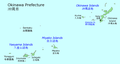 Map of Okinawa Prefecture with the location of Okinawa Island


_20150317-2.JPG)

Flora and fauna
The northern half of Okinawa has one of the largest tracts of subtropical rainforest in Asia called the Yanbaru. There are many endemic species of flora and fauna.[40][41] There are a small number of endemic Yanbaru kuina (also known as the Okinawa rail), a small flightless bird that is close to extinction. The critically endangered Okinawa woodpecker is also endemic to the island. The Indian mongoose was introduced to the island to prevent the native habu pit viper from attacking the birds. It did not succeed in eliminating the habu but instead preyed on birds, increasing the threat to the Okinawa rail.
The coconut crab is the largest terrestrial hermit crab of Okinawa and the Ryukyu Islands.[42] It is an endangered species due to over-hunting, which has made them scarce on Okinawa island.[42] In 2021, coconut crabs were found to live in a small cave system on the islet Nagashima off the Henoko district.[43]
A small population of endangered dugongs lives around Okinawa. The estimates are between 3 and 50 survivors.[44][45]
-
 The Okinawa rail
 -
 Coconut crab


Climate
The island has a humid subtropical climate bordering on a tropical rainforest climate. The climate supports a dense Subtropical forest in the northern Yanbaru National Park. A rainy season occurs in the late spring.[46]
| Climate data for Naha (1991−2020 normals, extremes 1890−present) | |||||||||||||
|---|---|---|---|---|---|---|---|---|---|---|---|---|---|
| Month | Jan | Feb | Mar | Apr | May | Jun | Jul | Aug | Sep | Oct | Nov | Dec | Year |
| Record high °C (°F) | 27.0 (80.6) |
27.1 (80.8) |
28.2 (82.8) |
30.6 (87.1) |
32.0 (89.6) |
34.3 (93.7) |
35.5 (95.9) |
35.6 (96.1) |
34.6 (94.3) |
33.0 (91.4) |
31.6 (88.9) |
29.4 (84.9) |
35.6 (96.1) |
| Mean daily maximum °C (°F) | 19.8 (67.6) |
20.2 (68.4) |
21.9 (71.4) |
24.3 (75.7) |
27.0 (80.6) |
29.8 (85.6) |
31.9 (89.4) |
31.8 (89.2) |
30.6 (87.1) |
28.1 (82.6) |
25.0 (77.0) |
21.5 (70.7) |
26.0 (78.8) |
| Daily mean °C (°F) | 17.3 (63.1) |
17.5 (63.5) |
19.1 (66.4) |
21.5 (70.7) |
24.2 (75.6) |
27.2 (81.0) |
29.1 (84.4) |
29.0 (84.2) |
27.9 (82.2) |
25.5 (77.9) |
22.5 (72.5) |
19.0 (66.2) |
23.3 (73.9) |
| Mean daily minimum °C (°F) | 14.9 (58.8) |
15.1 (59.2) |
16.7 (62.1) |
19.1 (66.4) |
22.1 (71.8) |
25.2 (77.4) |
27.0 (80.6) |
26.8 (80.2) |
25.8 (78.4) |
23.5 (74.3) |
20.4 (68.7) |
16.8 (62.2) |
21.1 (70.0) |
| Record low °C (°F) | 6.1 (43.0) |
4.9 (40.8) |
6.3 (43.3) |
8.7 (47.7) |
11.0 (51.8) |
14.8 (58.6) |
20.8 (69.4) |
20.7 (69.3) |
17.0 (62.6) |
14.8 (58.6) |
8.6 (47.5) |
6.8 (44.2) |
4.9 (40.8) |
| Average precipitation mm (inches) | 101.6 (4.00) |
114.5 (4.51) |
142.8 (5.62) |
161.0 (6.34) |
245.3 (9.66) |
Zdroj:https://en.wikipedia.org?pojem=Okinawa_(island)||||||||