

A | B | C | D | E | F | G | H | CH | I | J | K | L | M | N | O | P | Q | R | S | T | U | V | W | X | Y | Z | 0 | 1 | 2 | 3 | 4 | 5 | 6 | 7 | 8 | 9
Victoria | |||
|---|---|---|---|
| Nickname(s): The Garden State[1] | |||
| Motto: Peace and Prosperity | |||
| Country | Australia | ||
| Before federation | Colony of Victoria | ||
| Establishment separation from New South Wales | 1 July 1851[2] | ||
| Responsible government | 23 November 1855 | ||
| Federation | 1 January 1901 | ||
| Named for | Queen Victoria | ||
| Capital and largest city | Melbourne 37°48′51″S 144°57′47″E / 37.81417°S 144.96306°E | ||
| Administration | 79 local government areas | ||
| Demonym(s) | Victorian | ||
| Government | |||
• Monarch | Charles III | ||
• Governor | Margaret Gardner | ||
• Premier | Jacinta Allan (ALP) | ||
| Legislature | Parliament of Victoria | ||
| Legislative Council | |||
| Legislative Assembly | |||
| Judiciary | Supreme Court of Victoria | ||
| Parliament of Australia | |||
• Senate | 12 senators (of 76) | ||
| 39 seats (of 151) | |||
| Area | |||
• Land | 227,444[3] km2 (87,817 sq mi) | ||
| Highest elevation | 1,986 m (6,516 ft) | ||
| Population | |||
• December 2022 estimate | 6,704,300[4] (2nd) | ||
• Density | 29.5/km2 (76.4/sq mi) (2nd) | ||
| GSP | 2020 estimate | ||
• Total | AU$458.895 billion[5] (2nd) | ||
• Per capita | AU$68,996 (6th) | ||
| HDI (2021) | very high · 4th | ||
| Time zone | UTC+10:00 (AEST) | ||
• Summer (DST) | UTC+11:00 (AEDT) | ||
| Postal abbreviation | VIC | ||
| ISO 3166 code | AU–VIC | ||
| Symbols | |||
| Bird | Helmeted honeyeater (Lichenostomus melanops cassidix) | ||
| Fish | Weedy seadragon (Phyllopteryx taeniolatus) | ||
| Flower | Common heath[7] (Epacris impressa) | ||
| Mammal | Leadbeater's possum (Gymnobelideus leadbeateri) | ||
| Colour(s) | Navy blue and silver[8] | ||
| Fossil | Koolasuchus cleelandi | ||
| Mineral | Gold[9] | ||
| Website | vic | ||
.svg)


Victoria (commonly abbreviated as Vic) is a state in southeastern Australia. It is the second-smallest state, with a land area of 227,444 km2 (87,817 sq mi); the second-most-populated state (after New South Wales), with a population of over 6.7 million;[4] and the most densely populated state[10] in Australia (29.5 per km2). Victoria is bordered by New South Wales to the north and South Australia to the west and is bounded by the Bass Strait to the south (with the exception of a small land border with Tasmania located along Boundary Islet), the Great Australian Bight portion of the Southern Ocean to the southwest, and the Tasman Sea (a marginal sea of the South Pacific Ocean) to the southeast. The state encompasses a range of climates and geographical features from its temperate coastal and central regions to the Victorian Alps in the northeast and the semi-arid northwest.
The majority of the Victorian population is concentrated in the central-south area surrounding Port Phillip, and in particular within the metropolitan area of Greater Melbourne, Victoria's state capital and largest city and also Australia's second-largest city,[11] where over three-quarters of the Victorian population live. The state is home to four of Australia's 20 largest cities: Melbourne, Geelong, Ballarat and Bendigo. The population is culturally diverse, with 35.1% of inhabitants being immigrants.[12]
Victoria is home to numerous Aboriginal groups, including the Boonwurrung, the Bratauolung, the Djadjawurrung, the Gunai, the Gunditjmara, the Taungurung, the Wathaurong, the Wurundjeri, and the Yorta Yorta.[13] There were more than 30 Aboriginal languages spoken in the area prior to European colonisation. In 1770 James Cook claimed the east coast of the Australian continent for the Kingdom of Great Britain. The first European settlement in the area occurred in 1803 at Sullivan Bay. Much of what is now Victoria was included in 1836 in the Port Phillip District of New South Wales. Named in honour of Queen Victoria, Victoria was separated from New South Wales and established as a separate Crown colony in 1851, achieving responsible government in 1855.[14] The Victorian gold rush in the 1850s and 1860s significantly increased Victoria's population and wealth. By the time of Australian Federation in 1901, Melbourne had become the largest city in Australasia, and was the seat of Federal government until Canberra became the national capital in 1927. The state continued to grow strongly through various periods of the 20th and early 21st centuries as a result of high levels of international and interstate migration.
Victoria has 38 seats in the Australian House of Representatives and 12 seats in the Australian Senate. At state level, the Parliament of Victoria consists of the Legislative Assembly and the Legislative Council. The Labor Party, led by Jacinta Allan as premier, has governed Victoria since 2014. The Governor of Victoria, the representative of the monarch in the state, is currently Margaret Gardner. Victoria is divided into 79 local government areas, as well as several unincorporated areas which the state administers directly.
Victoria's economy is the second-largest among Australian states and is highly diversified, with service sectors predominating. Melbourne hosts a number of museums, art galleries, and theatres, and in 2016 a sport's marketing company named it the world's sporting capital.[15][16]
History
Indigenous Victorians
The state of Victoria was originally home to many Aboriginal Australian nations that had occupied the land for tens of thousands of years before European settlement.[17] According to Gary Presland, Aboriginal people have lived in Victoria for about 40,000 years,[18] living a semi-nomadic existence of fishing, hunting and gathering, and farming eels.[19]
At the Keilor Archaeological Site, a human hearth excavated in 1971 was radiocarbon-dated to about 31,000 years BP, making Keilor one of the earliest sites of human habitation in Australia.[20] A cranium found at the site has been dated at between 12,000[21] and 14,700 years BP.[20]
Archaeological sites in Tasmania and on the Bass Strait Islands have been dated to between 20,000 to 35,000 years ago when sea levels were 130 metres below present level allowing First Nations Peoples to move across the region of southern Victoria and onto the land bridge of the Bassian plain to Tasmania by at least 35,000 years ago.[22][23]
During the Ice Age about 20,000 years BP, the area now the bay of Port Phillip would have been dry land, and the Yarra and Werribee rivers would have joined to flow through the heads then south and south west through the Bassian plain before meeting the ocean to the west. Tasmania and the Bass Strait islands became separated from mainland Australia around 12,000 BP, when the sea level was approximately 50m below present levels.[22] Port Phillip was flooded by post-glacial rising sea levels between 8000 and 6000 years ago.[22]
Oral history and creation stories from the Wada wurrung, Woiwurrung and Bun wurrung languages describe the flooding of the bay. Hobsons Bay was once a kangaroo hunting ground. Creation stories describe how Bunjil was responsible for the formation of the bay,[23] or the bay was flooded when the Yarra River was created.[24]
British colonisation

Victoria, like Queensland, was named after Queen Victoria, who had been on the British throne for 14 years when the colony was established in 1851.[2]
After the founding of the colony of New South Wales in 1788, Australia was divided into an eastern half named New South Wales and a western half named New Holland, under the administration of the colonial government in Sydney. The first British settlement in the area later known as Victoria was established in October 1803 under Lieutenant-Governor David Collins at Sullivan Bay on Port Phillip. It consisted of 402 people (five government officials, nine officers of marines, two drummers, and 39 privates, five soldiers' wives and a child, 307 convicts, 17 convicts' wives, and seven children).[25] They had been sent from England in HMS Calcutta under the command of Captain Daniel Woodriff, principally out of fear that the French, who had been exploring the area, might establish their own settlement and thereby challenge British rights to the continent.
In 1826, Colonel Stewart, Captain Samuel Wright, and Lieutenant Burchell were sent in HMS Fly (Captain Wetherall) and the brigs Dragon and Amity, took a number of convicts and a small force composed of detachments of the 3rd and 93rd regiments. The expedition landed at Settlement Point (now Corinella), on the eastern side of Western Port Bay, which was the headquarters until the abandonment of Western Port at the insistence of Governor Darling about 12 months afterwards.[26][27]
Victoria's next settlement was at Portland, on the south west coast of what is now Victoria. Edward Henty settled Portland Bay in 1834.[28]
Batman's treaty
Melbourne was founded in 1835 by John Batman, who set up a base in Indented Head, and John Pascoe Fawkner. From settlement, the region around Melbourne was known as the Port Phillip District, a separately administered part of New South Wales. Shortly after, the site now known as Geelong was surveyed by Assistant Surveyor W. H. Smythe, three weeks after Melbourne. And in 1838, Geelong was officially declared a town, despite earlier European settlements dating back to 1826.
On 6 June 1835, just under two years before Melbourne was officially recognised as a settlement, John Batman, the leader of the Port Phillip Association presented Wurundjeri Elders with a land use agreement. This document, now referred to as the Batman treaty, was later given to the British government to claim that local Aboriginal people had given Batman access to their land in exchange for goods and rations. The treaty itself was declared void as Batman did not have permission from the Crown to establish Melbourne. Today, the meaning and interpretation of this treaty is contested. Some argue it was a pretence for taking Aboriginal land in exchange for trinkets, while others argue it was significant in that it sought to recognise Aboriginal land rights.
The exact location of the meeting between Batman and the Kulin men with whom he made the treaty is unknown, although it is believed to have been by the Merri Creek. According to historian Meyer Eidelson, it is generally believed to have occurred on the Merri near modern-day Rushall Station.[29]
Colonial Victoria
| Victoria Colony | |||||||||||
|---|---|---|---|---|---|---|---|---|---|---|---|
| British Crown Colony | |||||||||||
| 1851–1901 | |||||||||||
| Capital | Melbourne | ||||||||||
| Government | |||||||||||
| • Type | Self-governing colony | ||||||||||
| Monarch | |||||||||||
• 1851–1901 | Victoria | ||||||||||
| Governor | |||||||||||
• 1851–1854 | Charles La Trobe (first) | ||||||||||
• 1895–1900 | Thomas Brassey (last) | ||||||||||
| History | |||||||||||
• independence from the New South Wales colony | 1851 | ||||||||||
| 1901 | |||||||||||
| |||||||||||
.svg)
.svg)
On 1 July 1851, writs were issued for the election of the first Victorian Legislative Council, and the absolute independence of Victoria from New South Wales was established proclaiming a new Colony of Victoria.[30] Days later, still in 1851 gold was discovered near Ballarat, and subsequently at Bendigo. Later discoveries occurred at many sites across Victoria. This triggered one of the largest gold rushes the world has ever seen. The colony grew rapidly in both population and economic power. In 10 years, the population of Victoria increased sevenfold from 76,000 to 540,000. All sorts of gold records were produced, including the "richest shallow alluvial goldfield in the world" and the largest gold nugget. In the decade 1851–1860 Victoria produced 20 million ounces of gold, one-third of the world's output.[31]
In 1855 the Geological Survey collected and determined the major ion chemistry for groundwater in Victoria.[32]
Immigrants arrived from all over the world to search for gold, especially from Ireland and China.[33] By 1857, 26,000 Chinese miners worked in Victoria, and their legacy is particularly strong in Bendigo and its environs.
In 1854 at Ballarat, an armed rebellion against the government of Victoria was made by miners protesting against mining taxes (the "Eureka Stockade"). This was crushed by British troops, but the confrontation persuaded the colonial authorities to reform the administration of mining concessions (reducing the hated mining licence fees) and extend the electoral franchise. The following year, the Imperial Parliament granted Victoria responsible government with the passage of the Colony of Victoria Act 1855. Some of the leaders of the Eureka rebellion went on to become members of the Victorian Parliament.
In 1857, reflecting the growing presence of Irish Catholic immigrants, John O'Shanassy became the colony's second Premier with the former Young Irelander, Charles Gavan Duffy as his deputy. Melbourne's Protestant establishment was ill-prepared "to countenance so startling a novelty".[34] In 1858–59, Melbourne Punch cartoons linked Duffy and O'Shanassy to the terrors of the French Revolution.[35]
In 1862 Duffy's Land Act attempted, but failed, through a system of extended pastoral licences, to break the land-holding monopoly of the so-called "squatter" class.[36] In 1871, having led, on behalf of small farmers, opposition to Premier Sir James McCulloch's land tax, Duffy, himself, was briefly Premier.
In 1893 widespread bank failures brought to an end a sustained period of prosperity and of increasingly wild speculation in land and construction. Melbourne nonetheless retained, as the legacy of the gold rush, its status as Australia's primary financial centre and largest city.
In 1901, Victoria became a state in the Commonwealth of Australia. While Canberra was being built, Melbourne served until 1927 as the country's first federal capital.[37]
Geography
Victoria's northern border follows a straight line from Cape Howe to the start of the Murray River and then follows the Murray River as the remainder of the northern border. On the Murray River, the border is the southern bank of the river. This precise definition was not established until 1980, when a ruling by Justice Ninian Stephen of the High Court of Australia settled the question as to which state had jurisdiction in the unlawful death of a man on an island in the middle of the river. The ruling clarified that no part of the watercourse is in Victoria.[38][39] The border also rests at the southern end of the Great Dividing Range, which stretches along the east coast and terminates west of Ballarat. It is bordered by South Australia to the west and shares Australia's shortest land border with Tasmania. The official border between Victoria and Tasmania is at 39°12' S, which passes through Boundary Islet in the Bass Strait for 85 metres.[40][41][42]
Victoria contains many topographically, geologically and climatically diverse areas, ranging from the wet, temperate climate of Gippsland in the southeast to the snow-covered Victorian alpine areas which rise to almost 2,000 m (6,600 ft), with Mount Bogong the highest peak at 1,986 m (6,516 ft). There are extensive semi-arid plains to the west and northwest. There is an extensive series of river systems in Victoria. Most notable is the Murray River system. Other rivers include: Ovens River, Goulburn River, Patterson River, King River, Campaspe River, Loddon River, Wimmera River, Elgin River, Barwon River, Thomson River, Snowy River, Latrobe River, Yarra River, Maribyrnong River, Mitta River, Hopkins River, Merri River and Kiewa River. The state symbols include the pink heath (state flower), Leadbeater's possum (state animal) and the helmeted honeyeater (state bird). Ecological communities include Victorian Volcanic Plain grasslands, Northern Plains Grassland and Gippsland Plains Grassy Woodland, all of which are critically endangered.[43]
According to Geoscience Australia, the geographic centre of Victoria is located in Mandurang at 36° 51' 15"S, 144° 16' 52" E. The small rural locality is located 10 km (6 mi) south of Bendigo. Due to its central location and the region's historical ties to the gold rush, the town is widely regarded as the "Heart of Gold".
The state's capital, Melbourne, contains about 70% of the state's population and dominates its economy, media, and culture. For other cities and towns, see list of localities (Victoria) and local government areas of Victoria.
-
 Island Archway on the Great Ocean Road in Victoria, Australia
 -
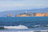 Aireys Inlet
 -
 Victorian cities, towns, settlements and road network


Regions

Victoria is divided into distinct geographic regions, most commonly for the purposes of economic development, while others for land management (e.g. agriculture or conservation) and for censusing (such as statistical or meteorological) or electoral purposes. Many regions have similar names and extents according to the different regionalisations, and the boundaries of regions can overlap even in popular usage.
In addition to Greater Melbourne, the Victoria State Government has divided Victoria into five regions covering all parts of the state. The five regional Victoria divisions are:[44]
The Australian Bureau of Meteorology defines regions for its own purposes, some of which share names with the economic regions, even though the exact boundaries may not correlate.[45] As of November 2014, they are:
- Mallee
- Wimmera
- Northern Country
- North East Victoria
- East Gippsland
- West & South Gippsland
- Central Victoria
- North Central Victoria
- South West Victoria
- Alpine Victoria
- Melbourne
Cities and towns
This is a list of places in the Australian state of Victoria by population.
Urban centres are defined by the Australian Bureau of Statistics as being a population cluster of 1,000 or more people. The below figures broadly represent the populations of the contiguous built-up areas of each city.
| Rank | Urban centre | Population | |||
|---|---|---|---|---|---|
| 2006 census | 2011 census | 2016 census | 2021 census | ||
| 1 | Melbourne | 3,375,341 | 3,707,530 | 4,196,201 | 4,917,750 |
| 2 | Geelong | 135,965 | 143,921 | 157,103 | 180,239[46] |
| 3 | Ballarat | 77,766 | 85,936 | 93,761 | 116,201 |
| 4 | Bendigo | 75,420 | 82,795 | 92,384 | 103,034 |
| 5 | Melton | 35,194 | 45,625 | 54,455 | N/A |
| 6 | Mildura | 30,761 | 31,363 | 33,445 | 56,972 |
| 7 | Shepparton – Mooroopna | 38,247 | 42,742 | 46,194 | 68,409 |
| – | Pakenham | 18,621 | 32,913 | 46,421
Zdroj:https://en.wikipedia.org?pojem=Victoria_(Australia) Text je dostupný za podmienok Creative Commons Attribution/Share-Alike License 3.0 Unported; prípadne za ďalších podmienok. Podrobnejšie informácie nájdete na stránke Podmienky použitia.
Analytika
Antropológia Aplikované vedy Bibliometria Dejiny vedy Encyklopédie Filozofia vedy Forenzné vedy Humanitné vedy Knižničná veda Kryogenika Kryptológia Kulturológia Literárna veda Medzidisciplinárne oblasti Metódy kvantitatívnej analýzy Metavedy Metodika Text je dostupný za podmienok Creative
Commons Attribution/Share-Alike License 3.0 Unported; prípadne za ďalších
podmienok. www.astronomia.sk | www.biologia.sk | www.botanika.sk | www.dejiny.sk | www.economy.sk | www.elektrotechnika.sk | www.estetika.sk | www.farmakologia.sk | www.filozofia.sk | Fyzika | www.futurologia.sk | www.genetika.sk | www.chemia.sk | www.lingvistika.sk | www.politologia.sk | www.psychologia.sk | www.sexuologia.sk | www.sociologia.sk | www.veda.sk I www.zoologia.sk | |