A | B | C | D | E | F | G | H | CH | I | J | K | L | M | N | O | P | Q | R | S | T | U | V | W | X | Y | Z | 0 | 1 | 2 | 3 | 4 | 5 | 6 | 7 | 8 | 9
Stockton | |
|---|---|
| Nickname(s): | |
| Motto: "Stockton: All American City"[3] | |
| Coordinates: 37°58′32″N 121°18′03″W / 37.97556°N 121.30083°W | |
| Country | United States |
| State | California |
| Region | San Joaquin Valley |
| County | San Joaquin |
| Incorporated | July 23, 1850[4] |
| Named for | Robert F. Stockton |
| Government | |
| • Type | City Manager-Council[5] |
| • Mayor | Kevin J. Lincoln, II (R) |
| • City council | Michele Padilla[6] Daniel Wright[7] Michael Blower[8] Susan Lenz[9] Brando Villapudua[10] Kimberly Warmsley[11] |
| • City manager | Harry E. Black[12] |
| • State senator | Susan Eggman (D)[13] |
| • Assemblymember | Carlos Villapudua (D)[13] |
| Area | |
| • City | 65.25 sq mi (169.01 km2) |
| • Land | 62.17 sq mi (161.02 km2) |
| • Water | 3.08 sq mi (7.99 km2) 4.76% |
| Elevation | 13 ft (4 m) |
| Population | |
| • City | 320,804 |
| • Rank | 1st in San Joaquin County 11th in California 58th in the United States |
| • Density | 4,900/sq mi (1,900/km2) |
| • Urban | 414,847 (US: 101st) |
| • Urban density | 4,486.7/sq mi (1,732.3/km2) |
| • Metro | 779,233 (US: 76th) |
| Demonym | Stocktonian |
| Time zone | UTC−8 (Pacific) |
| • Summer (DST) | UTC−7 (PDT) |
| ZIP Codes | 95201–95213, 95215, 95219, 95267, 95269, 95296–95297 |
| Area code | 209 |
| FIPS code | 06-75000 |
| GNIS feature IDs | 1659872, 2411987 |
| Website | www |
Stockton is a city in and the county seat of San Joaquin County in the Central Valley of the U.S. state of California.[18] Stockton is the most populous city in the county, the 11th-most populous city in California and the 58th-most populous city in the United States. Stockton's population in 2020 was 320,804. It was named an All-America City in 1999, 2004, 2015, and again in 2017 and 2018. The city is located on the San Joaquin River in the northern San Joaquin Valley. It lies at the southeastern corner of a large inland river delta that isolates it from other nearby cities such as Sacramento and those of the San Francisco Bay Area.
Stockton was founded by Charles Maria Weber in 1849 after he acquired Rancho Campo de los Franceses. The city is named after Robert F. Stockton,[19] and it was the first community in California to have a name not of Spanish or Native American origin.
Built during the California Gold Rush, Stockton's seaport serves as a gateway to the Central Valley and beyond. It provided easy access for trade and transportation to the southern gold mines. The University of the Pacific (UOP), chartered in 1851, is the oldest university in California, and has been located in Stockton since 1923. In 2012, Stockton filed for what was then the largest municipal bankruptcy in US history – which had multiple causes, including financial mismanagement in the 1990s, generous fringe benefits to unionized city employees,[20] and the 2008 financial crisis. Stockton successfully exited bankruptcy in February 2015.
History
When Europeans first arrived in the Stockton area, it was occupied by the Yatchicumne, a branch of the Northern Valley Yokuts Indians. They built their villages on low mounds to keep their homes above regular floods. A Yokuts village named Pasasimas was located on a mound between Edison and Harrison Streets on what is now the Stockton Channel in downtown Stockton.[21]
The Siskiyou Trail began in the northern San Joaquin Valley. It was a centuries-old Native American footpath that led through the Sacramento Valley over the Cascades and into present-day Oregon.[22]
The extensive network of waterways in and around Stockton was fished and navigated by Miwok Indians for centuries. During the California Gold Rush, the San Joaquin River was navigable by ocean-going vessels, making Stockton a natural inland seaport and point of supply and departure for prospective gold-miners. From the mid-19th century onward, Stockton became the region's transportation hub, dealing mainly with agricultural products.
19th century


Mexican era
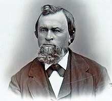
Carlos Maria Weber was a German émigré in the United States in 1836. He was born as Carl David Weber (February 18, 1814, in Steinwenden – May 4, 1881, in Stockton) and then went by Charles in 1836 in the United States, first spending time in New Orleans and then in Texas. He then came overland from Missouri to California with the Bartleson-Bidwell Party in 1841 and began to go by Carlos, when he began working for John Sutter. In 1842 Weber settled in the Pueblo of San José.
As an alien, Weber could not secure a land grant directly, so he formed a partnership with Guillermo (William) Gulnac. Born in New York, Gulnac had married a Mexican woman and sworn allegiance to Mexico, which then ruled California. He applied in Weber's place for Rancho Campo de los Franceses, a land grant of 11 square leagues on the east side of the San Joaquin River.[23]
Gulnac and Weber dissolved their partnership in 1843. Gulnac's attempts to settle the Rancho Campo de los Franceses failed, and Weber acquired it in 1845. In 1846 Weber had induced a number of settlers to locate on the rancho, when the Mexican–American War broke out. Considered a Californio, Weber was offered the position of captain by Mexican general José Castro, which he declined; he later, however, accepted the position of captain in the Cavalry of the United States. Captain Weber's decision to change sides lost him a great deal of the trust he had built up among his Mexican business partners. As a result, he moved to the grant in 1847 and sold his business in San Jose in 1849.
Gold Rush era
At the start of the California Gold Rush in 1848, Europeans and Americans started to arrive in the area of Weber's rancho on their way to the goldfields. When Weber decided to try his hand at gold mining in late 1848, he soon found selling supplies to gold-seekers was more profitable.[24]
As the head of navigation on the San Joaquin River, the city grew rapidly as a miners' supply point during the Gold Rush. Weber built the first permanent residence in the San Joaquin Valley on a piece of land now known as Weber Point.[21] During the Gold Rush, the location of what is now Stockton developed as a river port, the hub of roads to the gold settlements in the San Joaquin Valley and northern terminus of the Stockton - Los Angeles Road. During its early years, Stockton was known by several names, including "Weberville," "Fat City," "Mudville" and "California's Sunrise Seaport."[2] In 1849 Weber laid out a town, which he named "Tuleburg," but he soon decided on "Stockton" in honor of Commodore Robert F. Stockton. Stockton was the first community in California to have a name that was neither Spanish nor Native American in origin.[1]
Chinese immigration
Thousands of Chinese came to Stockton from the Guangdong province of China during the 1850s due to a combination of political and economic unrest in China and the discovery of gold in California. After the gold rush, many worked for the railroads and land reclamation projects in the Sacramento–San Joaquin River Delta and remained in Stockton. By 1880 Stockton was home to the third-largest Chinese community in California. Discriminatory laws, in particular the Chinese Exclusion Act of 1882, restricted immigration and prevented the Chinese from buying property.[25] The Lincoln Hotel, built in 1920 by the Wong brothers on South El Dorado Street, was considered one of Stockton's finest hotels of the time. Only after the Magnuson Act was repealed in 1962 were American-born Chinese allowed to buy property and own buildings.[26][27]
Incorporation
The city was officially incorporated on July 23, 1850, by the county court, and the first city election was held on July 31, 1850. In 1851 the City of Stockton received its charter from the State of California. Early settlers included gold seekers from Asia, Africa, Australia, Europe, the Pacific Islands, Mexico and Canada. The historical population diversity is reflected in Stockton street names, architecture, numerous ethnic festivals and the faces and heritage of a majority of its citizens. In 1870 the Census Bureau reported Stockton's population as 87.6% white and 10.7% Asian. Many Chinese were immigrating to California as workers in these years, especially for the Transcontinental Railroad.[28]
Benjamin Holt settled in Stockton in 1883 and with his three brothers founded the Stockton Wheel Co., and later the Holt Manufacturing Company.
20th century


On Thanksgiving Day, November 24, 1904, Holt successfully tested the first workable track-laying machine, plowing soggy San Joaquin Valley Delta farmland.[29] Company photographer Charles Clements was reported to have observed that the tractor crawled like a caterpillar, and Holt seized on the metaphor. "Caterpillar it is. That's the name for it."[30]
On April 22, 1918, British Army Col. Ernest Dunlop Swinton visited Stockton while on a tour of the United States. The British and French armies were using many hundreds of Holt tractors to haul heavy guns and supplies during World War I, and Swinton publicly thanked Holt and his workforce for their contribution to the war effort.[31] During 1914 and 1915, Swinton had advocated basing some sort of armored fighting vehicle on Holt's caterpillar tractors, but without success (although Britain did develop tanks, they came from a separate source and were not directly derived from Holt machines).[32] After the appearance of tanks on the battlefield, Holt built a prototype, the gas-electric tank, but it did not enter production.
On January 10, 1920, a major fire on Main Street threatened an entire city block. At about 2 a.m., a blaze was discovered in the basement of the Yost-Dohrmann store, which was gutted, and adjacent businesses were damaged by flames and water. Damage was estimated at $150,000.[33]
By 1931, the Stockton Electric Railroad Co. operated 40 streetcars over 28 miles (45 km) of track.[34]
Stockton is the site of the first Sikh temple in the United States; Gurdwara Sahib Stockton opened on October 24, 1912. It was founded by Baba Jawala Singh and Baba Wasakha Singh, successful Punjabi immigrants who farmed and owned 500 acres (202 ha) on the Holt River.[35]
In 1933, the port was modernized, and the Stockton Deepwater Channel, which improved water passage to San Francisco Bay, was deepened and completed. This created commercial opportunities that fueled the city's growth. Ruff and Ready Island Naval Supply Depot was established, placing Stockton in a strategic position during the Cold War.[36] During the Great Depression the town's canning industry became the battleground of a labor dispute resulting in the Spinach Riot of 1937.[37]

During World War II, the Stockton Assembly Center was built on the San Joaquin County Fairgrounds, a few blocks from what was then the city center. One of 15 temporary detention sites run by the Wartime Civilian Control Administration, the center held some 4,200 Japanese-Americans removed from their West Coast homes under Executive Order 9066, while they waited for transfer to more permanent and isolated camps in the interior of the country. The center opened on May 10, 1942, and operated until October 17, when the majority of its population was sent to Rohwer, Arkansas. The former incarceration site was named a California Historical Landmark in 1980, and in 1984 a marker was erected at the entrance to the fairgrounds.[38]
In 1979, the development of a residential area in Stockton at a burial ground of the tribe unearthed two hundred Miwok remains. In an attempt to prevent the further desecration of the burial grounds, a descendant of the people initiated a legal case which became Wana the Bear v. Community Construction (1982). The decision ultimately sided with the development company, which was heavily criticized by Native Americans as a display of ethnocentrism.[39][40]
In September 1996, the Base Realignment and Closure Commission announced the final closure of Stockton's Naval Reserve Center on Rough and Ready Island. Formerly known as Ruff and Ready Island Naval Supply Depot, the island's facilities had served as a major communications outpost for submarine activities in the Pacific during the Cold War. The site is slowly being redeveloped as commercial property.[41]
Geography
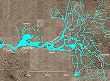
Stockton is situated amidst the farmland of California's San Joaquin Valley, a subregion of the Central Valley. In and around Stockton are thousands of miles of waterways that make up the California Delta.
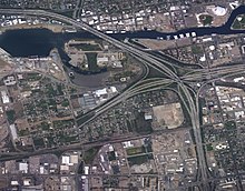
Interstate 5 and State Route 99, inland California's major north–south highways, pass through the city. State Route 4 and the dredged San Joaquin River connect the city with the San Francisco Bay Area to its west, creating the Stockton Deepwater Shipping Channel. Stockton and Sacramento are California's only inland sea ports.
According to the United States Census Bureau, the city occupies a total area of 64.8 square miles (168 km2), of which 61.7 square miles (160 km2) is land and 3.1 square miles (8.0 km2), comprising 4.76%, is water.
Economy
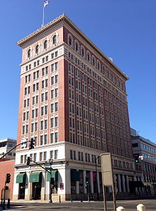
Historically an agricultural community, Stockton's economy has since diversified into other industries, which include telecommunications and manufacturing.
Stockton's central location, relative to both San Francisco and Sacramento, as well as its proximity to the state and interstate freeway system, together with its comparatively inexpensive land costs, have prompted several companies to base their regional operations in the city.
Shopping
The city of Stockton has two shopping malls, located adjacent to each other: Weberstown Mall and Sherwood Mall. It has the only Dillard's in the Northern California region at the Weberstown Mall, as well as one of the three Sears stores still operating in the Northern California region.
Construction and public spending

Beginning in the late 1990s, Stockton had commenced some revitalization projects.[42] Newly built or renovated buildings include the Bob Hope Theater, Regal City Centre Cinemas and IMAX, San Joaquin RTD Downtown Transit Center, Lexington Plaza Waterfront Hotel, Hotel Stockton, Stockton Arena, the San Joaquin County Administration Building, and the Stockton Ballpark.[citation needed]
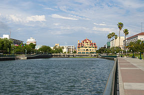
A new downtown marina and adjacent Joan Darah Promenade were added along the south shore of the Stockton Deep Water Channel during 2009. Various public art projects were also installed throughout the area (see Stockton's public art section).[citation needed]
Real estate bubble
The Stockton real estate market was disproportionately affected by the 2007 subprime mortgage financial crisis, and the city led the United States in foreclosures for that year, with one of every 30 homes posted for foreclosure.[43] From September 2006 to September 2007, the value of a median-priced house in Stockton declined by 44%.[44]
Stockton's Weston Ranch neighborhood, a subdivision of modest tract homes built in the mid-1990s, had the worst foreclosure rate in the area according to ACORN, a now defunct national advocacy group for low and moderate-income families.[citation needed] Stockton found itself squarely at the center of the 2000s' speculative housing bubble. Real estate in Stockton more than tripled in value between 1998 and 2005, but when the bubble burst in 2007, the ensuing financial crisis made Stockton one of the hardest-hit cities in United States.[45]
Stockton housing prices fell 39% in the 2008 fiscal year, and the city had the country's highest foreclosure rate (9.5%) as well. Stockton also had an unemployment rate of 13.3% in 2008, one of the highest in the United States. Stockton was rated by Forbes in 2009 as America's fifth most dangerous city because of its crime rate.[45] In 2010, mainly due to the aforementioned factors, Forbes named it one of the three worst places to live in the United States.[46]
City bankruptcy
Following the 2008 financial crisis, in June 2012 Stockton became the largest city in U.S. history to file for bankruptcy protection. It was surpassed by Detroit in July 2013. The city approved a plan to exit bankruptcy in October 2013,[47] and voters approved a sales tax on November 5, 2013, to help fund the exit.[48]
The collapse in real estate valuations had a negative effect on the city's revenue base. On June 28, 2012, Stockton filed for Chapter 9 bankruptcy.[49] On April 1, 2013, the United States Bankruptcy Court Eastern District of California ruled that Stockton was eligible for bankruptcy protection.
The Stockton bankruptcy case lasted longer than two years and received nationwide attention. On October 4, 2013, Stockton City Council approved a bankruptcy exit plan by a 6–0 vote[47] to be filed with the U.S. Bankruptcy Court, Eastern District of California, Sacramento. Voters approved a 3⁄4-cent sales tax on November 5, 2013, to help fund the bankruptcy exit.[48]
On October 30, 2014, a federal bankruptcy judge approved the city's bankruptcy recovery plan, thus allowing the city to continue with the planned pension payments to retired workers.[50] The city exited from Chapter 9 bankruptcy on February 25, 2015.
Experiment in Guaranteed Basic Income
As part of a privately funded experiment in Universal Basic Income in 2019, the Stockton Economic Empowerment Demonstration (S.E.E.D.) conducted a pilot project that gave a $500 stipend to 125 randomly selected residents for an 24-month period with “no strings attached."[51] It was made possible by the Economic Security Project,[52] an advocacy group chaired by Facebook co-founder Chris Hughes, which provided the first $1 million for the program, and a dozen other Silicon Valley organizations and private donors who funded the rest of its $3 million budget.[53][54] The positive benefits of the program during the first year were described in an interim report published in March 2021.[55]
Climate
Stockton's climate lies right on the boundary of, and fluctuates between, hot-summer Mediterranean (Köppen: Csa) and cool semi-arid (BSk). Stockton is characterized by very hot, arid summer and cool, wet winter. In an average year, nearly 95% of the 13.45 inches (341.6 mm) of precipitation falls from October through April.[56] Located in the Central Valley, the temperature range is much greater than in the nearby Bay Area. The degree of diurnal temperature variation is roughly twice as high in the summer as in the winter. Tule fog blankets the area during some winter days. Stockton lies in the fertile heart of the California Mediterranean climate prairie delta, about equidistant from the Pacific Ocean and the Sierra Nevada.[citation needed] The intermediate climate between the coast and the Central Valley gives a similar climate to that of Badajoz, Spain.[57]
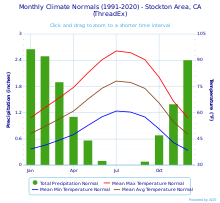
At the airport, the highest recorded temperature was 115 °F (46 °C) on July 23, 2006, and September 6, 2022, and the lowest was 16 °F (−9 °C) on January 11, 1949. There are an average of 88 afternoons annually with high temperatures of 90 °F (32.2 °C) or higher, and 19 afternoons of 100 °F (37.8 °C) or above; 19 mornings see low temperatures at or below freezing. The wettest "rain year" was from July 1982 to June 1983 with 27.89 inches (708.4 mm) and the driest from July 1975 to June 1976 with 5.71 inches (145.0 mm).[58] Note that regional difference of precipitation has been recorded in Stockton. The more northern part of Stockton receives more precipitation than southern Stockton.
The most rainfall in one month was 8.22 inches (208.8 mm) in February 1998 and the most rainfall in 24 hours was 3.01 inches (76.5 mm) on January 21, 1967.[58] There are an average of 56.5 days with measurable precipitation.[56] Only light amounts of snow have been recorded, and the only instance of measurable snowfall occurred on February 5, 1976, with 0.3 in (0.8 cm) measured.[58]
A 2018 federal study predicts that flooding of the San Joaquin River could possibly cause much of Stockton to become submerged beneath 10–12 feet of water, causing a humanitarian disaster as costly and deadly as Hurricane Katrina if the levees are not upgraded.[59][60]
| Climate data for Stockton Metropolitan Airport, California (1991–2020 normals,[a] extremes 1948–present) | |||||||||||||
|---|---|---|---|---|---|---|---|---|---|---|---|---|---|
| Month | Jan | Feb | Mar | Apr | May | Jun | Jul | Aug | Sep | Oct | Nov | Dec | Year |
| Record high °F (°C) | 78 (26) |
79 (26) |
87 (31) |
100 (38) |
107 (42) |
111 (44) |
115 (46) |
113 (45) |
115 (46) |
101 (38) |
85 (29) |
76 (24) |
115 (46) |
| Mean maximum °F (°C) | 65.3 (18.5) |
71.6 (22.0) |
79.3 (26.3) |
89.3 (31.8) |
97.3 (36.3) |
104.3 (40.2) |
105.8 (41.0) |
104.9 (40.5) |
101.4 (38.6) |
92.2 (33.4) |
77.8 (25.4) |
65.9 (18.8) |
107.7 (42.1) |
| Mean daily maximum °F (°C) | 57.0 (13.9) |
62.9 (17.2) |
68.5 (20.3) |
74.5 (23.6) |
82.8 (28.2) |
90.4 (32.4) |
95.4 (35.2) |
94.4 (34.7) |
90.4 (32.4) |
80.3 (26.8) |
66.6 (19.2) |
57.1 (13.9) |
76.7 (24.8) |
| Daily mean °F (°C) | 48.0 (8.9) |
52.1 (11.2) |
56.4 (13.6) |
60.9 (16.1) |
67.7 (19.8) |
74.0 (23.3) |
78.1 (25.6) |
77.3 (25.2) |
73.9 (23.3) |
65.5 (18.6) |
54.7 (12.6) |
47.7 (8.7) |
63.0 (17.2) |
| Mean daily minimum °F (°C) | 39.1 (3.9) |
41.3 (5.2) |
44.2 (6.8) |
47.4 (8.6) Zdroj:https://en.wikipedia.org?pojem=History_of_Stockton,_California Text je dostupný za podmienok Creative Commons Attribution/Share-Alike License 3.0 Unported; prípadne za ďalších podmienok. Podrobnejšie informácie nájdete na stránke Podmienky použitia.
Analytika
Antropológia Aplikované vedy Bibliometria Dejiny vedy Encyklopédie Filozofia vedy Forenzné vedy Humanitné vedy Knižničná veda Kryogenika Kryptológia Kulturológia Literárna veda Medzidisciplinárne oblasti Metódy kvantitatívnej analýzy Metavedy Metodika Text je dostupný za podmienok Creative
Commons Attribution/Share-Alike License 3.0 Unported; prípadne za ďalších
podmienok. www.astronomia.sk | www.biologia.sk | www.botanika.sk | www.dejiny.sk | www.economy.sk | www.elektrotechnika.sk | www.estetika.sk | www.farmakologia.sk | www.filozofia.sk | Fyzika | www.futurologia.sk | www.genetika.sk | www.chemia.sk | www.lingvistika.sk | www.politologia.sk | www.psychologia.sk | www.sexuologia.sk | www.sociologia.sk | www.veda.sk I www.zoologia.sk | |||||||||

