A | B | C | D | E | F | G | H | CH | I | J | K | L | M | N | O | P | Q | R | S | T | U | V | W | X | Y | Z | 0 | 1 | 2 | 3 | 4 | 5 | 6 | 7 | 8 | 9
| Earth radius | |
|---|---|
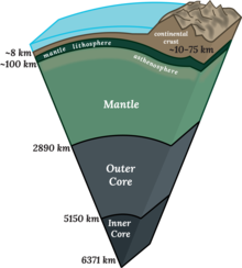
 Cross section of Earth's Interior | |
| General information | |
| Unit system | astronomy, geophysics |
| Unit of | distance |
| Symbol | R🜨, , |
| Conversions | |
| 1 R🜨 in ... | ... is equal to ... |
| SI base unit | 6.3781×10⁶ m[1] |
| Metric system | 6,357 to 6,378 km |
| English units | 3,950 to 3,963 mi |
| Geodesy |
|---|
 |
Earth radius (denoted as R🜨 or ) is the distance from the center of Earth to a point on or near its surface. Approximating the figure of Earth by an Earth spheroid, the radius ranges from a maximum of nearly 6,378 km (3,963 mi) (equatorial radius, denoted a) to a minimum of nearly 6,357 km (3,950 mi) (polar radius, denoted b).
A nominal Earth radius is sometimes used as a unit of measurement in astronomy and geophysics, which is recommended by the International Astronomical Union to be the equatorial value.[1]
A globally-average value is usually considered to be 6,371 kilometres (3,959 mi) with a 0.3% variability (±10 km) for the following reasons. The International Union of Geodesy and Geophysics (IUGG) provides three reference values: the mean radius (R1) of three radii measured at two equator points and a pole; the authalic radius, which is the radius of a sphere with the same surface area (R2); and the volumetric radius, which is the radius of a sphere having the same volume as the ellipsoid (R3).[2] All three values are about 6,371 kilometres (3,959 mi).
Other ways to define and measure the Earth's radius involve the radius of curvature. A few definitions yield values outside the range between the polar radius and equatorial radius because they include local or geoidal topography or because they depend on abstract geometrical considerations.
Introduction

Earth's rotation, internal density variations, and external tidal forces cause its shape to deviate systematically from a perfect sphere.[a] Local topography increases the variance, resulting in a surface of profound complexity. Our descriptions of Earth's surface must be simpler than reality in order to be tractable. Hence, we create models to approximate characteristics of Earth's surface, generally relying on the simplest model that suits the need.
Each of the models in common use involve some notion of the geometric radius. Strictly speaking, spheres are the only solids to have radii, but broader uses of the term radius are common in many fields, including those dealing with models of Earth. The following is a partial list of models of Earth's surface, ordered from exact to more approximate:
- The actual surface of Earth
- The geoid, defined by mean sea level at each point on the real surface[b]
- A spheroid, also called an ellipsoid of revolution, geocentric to model the entire Earth, or else geodetic for regional work[c]
- A sphere
In the case of the geoid and ellipsoids, the fixed distance from any point on the model to the specified center is called "a radius of the Earth" or "the radius of the Earth at that point".[d] It is also common to refer to any mean radius of a spherical model as "the radius of the earth". When considering the Earth's real surface, on the other hand, it is uncommon to refer to a "radius", since there is generally no practical need. Rather, elevation above or below sea level is useful.
Regardless of the model, any of these geocentric radii falls between the polar minimum of about 6,357 km and the equatorial maximum of about 6,378 km (3,950 to 3,963 mi). Hence, the Earth deviates from a perfect sphere by only a third of a percent, which supports the spherical model in most contexts and justifies the term "radius of the Earth". While specific values differ, the concepts in this article generalize to any major planet.
Physics of Earth's deformation
Rotation of a planet causes it to approximate an oblate ellipsoid/spheroid with a bulge at the equator and flattening at the North and South Poles, so that the equatorial radius a is larger than the polar radius b by approximately aq. The oblateness constant q is given by
where ω is the angular frequency, G is the gravitational constant, and M is the mass of the planet.[e] For the Earth 1/q ≈ 289, which is close to the measured inverse flattening 1/f ≈ 298.257. Additionally, the bulge at the equator shows slow variations. The bulge had been decreasing, but since 1998 the bulge has increased, possibly due to redistribution of ocean mass via currents.[4]

The variation in density and crustal thickness causes gravity to vary across the surface and in time, so that the mean sea level differs from the ellipsoid. This difference is the geoid height, positive above or outside the ellipsoid, negative below or inside. The geoid height variation is under 110 m (360 ft) on Earth. The geoid height can change abruptly due to earthquakes (such as the Sumatra-Andaman earthquake) or reduction in ice masses (such as Greenland).[5]
Not all deformations originate within the Earth. Gravitational attraction from the Moon or Sun can cause the Earth's surface at a given point to vary by tenths of a meter over a nearly 12-hour period (see Earth tide).
Radius and local conditions

Given local and transient influences on surface height, the values defined below are based on a "general purpose" model, refined as globally precisely as possible within 5 m (16 ft) of reference ellipsoid height, and to within 100 m (330 ft) of mean sea level (neglecting geoid height).
Additionally, the radius can be estimated from the curvature of the Earth at a point. Like a torus, the curvature at a point will be greatest (tightest) in one direction (north–south on Earth) and smallest (flattest) perpendicularly (east–west). The corresponding radius of curvature depends on the location and direction of measurement from that point. A consequence is that a distance to the true horizon at the equator is slightly shorter in the north–south direction than in the east–west direction.
In summary, local variations in terrain prevent defining a single "precise" radius. One can only adopt an idealized model. Since the estimate by Eratosthenes, many models have been created. Historically, these models were based on regional topography, giving the best reference ellipsoid for the area under survey. As satellite remote sensing and especially the Global Positioning System gained importance, true global models were developed which, while not as accurate for regional work, best approximate the Earth as a whole.
Extrema: equatorial and polar radii
The following radii are derived from the World Geodetic System 1984 (WGS-84) reference ellipsoid.[6] It is an idealized surface, and the Earth measurements used to calculate it have an uncertainty of ±2 m in both the equatorial and polar dimensions.[7] Additional discrepancies caused by topographical variation at specific locations can be significant. When identifying the position of an observable location, the use of more precise values for WGS-84 radii may not yield a corresponding improvement in accuracy.[clarification needed]
The value for the equatorial radius is defined to the nearest 0.1 m in WGS-84. The value for the polar radius in this section has been rounded to the nearest 0.1 m, which is expected to be adequate for most uses. Refer to the WGS-84 ellipsoid if a more precise value for its polar radius is needed.
- The Earth's equatorial radius a, or semi-major axis, is the distance from its center to the equator and equals 6,378.1370 km (3,963.1906 mi).[8] The equatorial radius is often used to compare Earth with other planets.
- The Earth's polar radius b, or semi-minor axis, is the distance from its center to the North and South Poles, and equals 6,356.7523 km (3,949.9028 mi).
Location-dependent radii

Geocentric radius
The geocentric radius is the distance from the Earth's center to a point on the spheroid surface at geodetic latitude φ:
where a and b are, respectively, the equatorial radius and the polar radius.
The extrema geocentric radii on the ellipsoid coincide with the equatorial and polar radii. They are vertices of the ellipse and also coincide with minimum and maximum radius of curvature.
Radii of curvature
Principal radii of curvature
There are two principal radii of curvature: along the meridional and prime-vertical normal sections.
Meridional
In particular, the Earth's meridional radius of curvature (in the north–south direction) at φ is:[9]
where is the eccentricity of the earth. This is the radius that Eratosthenes measured in his arc measurement.
Prime vertical

If one point had appeared due east of the other, one finds the approximate curvature in the east–west direction.[f]
This Earth's prime-vertical radius of curvature, also called the Earth's transverse radius of curvature, is defined perpendicular (orthogonal) to M at geodetic latitude φ[g] and is:[9]
Antropológia
Aplikované vedy
Bibliometria
Dejiny vedy
Encyklopédie
Filozofia vedy
Forenzné vedy
Humanitné vedy
Knižničná veda
Kryogenika
Kryptológia
Kulturológia
Literárna veda
Medzidisciplinárne oblasti
Metódy kvantitatívnej analýzy
Metavedy
Metodika
Text je dostupný za podmienok Creative
Commons Attribution/Share-Alike License 3.0 Unported; prípadne za ďalších
podmienok.
Podrobnejšie informácie nájdete na stránke Podmienky
použitia.
www.astronomia.sk | www.biologia.sk | www.botanika.sk | www.dejiny.sk | www.economy.sk | www.elektrotechnika.sk | www.estetika.sk | www.farmakologia.sk | www.filozofia.sk | Fyzika | www.futurologia.sk | www.genetika.sk | www.chemia.sk | www.lingvistika.sk | www.politologia.sk | www.psychologia.sk | www.sexuologia.sk | www.sociologia.sk | www.veda.sk I www.zoologia.sk


