
A | B | C | D | E | F | G | H | CH | I | J | K | L | M | N | O | P | Q | R | S | T | U | V | W | X | Y | Z | 0 | 1 | 2 | 3 | 4 | 5 | 6 | 7 | 8 | 9
Cambridge | |
|---|---|
| City of Cambridge | |
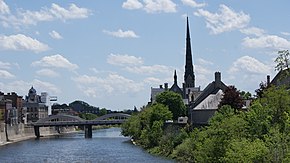 Grand River scene facing downtown Cambridge (Galt) | |
| Nicknames: The Bridge, the Tri-City | |
| Motto(s): "A fine place for business, a great place to call home." | |
| Coordinates: 43°23′50″N 80°18′41″W / 43.39722°N 80.31139°W | |
| Country | Canada |
| Province | Ontario |
| Region | Waterloo |
| Established | January 1973 |
| Government | |
| • Mayor | Jan Liggett |
| • Governing Body | Cambridge City Council |
| Area | |
| • Land | 112.99 km2 (43.63 sq mi) |
| Elevation | 329 m (1,079 ft) |
| Population | |
| • City (lower-tier) | 138,479 (41st) |
| • Density | 1,225.5/km2 (3,174/sq mi) |
| • Metro | 575,847 (10th) |
| Time zone | UTC−5 (Eastern (EST)) |
| Forward sortation area | |
| Area code(s) | 519, 226, and 548 |
| Highways | |
| GNBC Code | FANXK[3] |
| Website | cambridge.ca |
Cambridge is a city in the Regional Municipality of Waterloo, Ontario, Canada, located at the confluence of the Grand and Speed rivers. The city had a population of 138,479 as of the 2021 census.[1] Along with Kitchener and Waterloo, Cambridge is one of the three core cities of Canada's tenth-largest metropolitan area.
Cambridge was formed in 1973 by the amalgamation of Galt, Preston, Hespeler, the settlement of Blair and a small portion of surrounding townships.[4] The former Galt covers the largest portion of Cambridge, making up the southern half of the city, while Preston and Blair cover the western side. Hespeler makes up the most northeastern section of Cambridge. Historical information and records of each entity are well documented in the Cambridge City Archives.[5]
History
History of the City of Galt
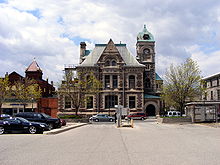
Galt is situated on land once granted to the Iroquois people by the British Crown at the end of the American Revolutionary War.[6] In the late 1700s, developers began to buy land around the Grand River from the Six Nations who were led by Joseph Brant.[citation needed] One speculator, William Dickson, a wealthy immigrant from Scotland, bought 90,000 acres (360 km2) of land along the Grand River in 1816; this was later to become Galt and the Dumfries Townships. Dickson divided the land and sold smaller lots, particularly to Scottish settlers. The centre of the planned community was built at the junction of Mill Creek and the Grand River, then called Shade's Mills.[citation needed]
Dickson decided to name the Post Office Galt, in honour of John Galt of the Canada Company which was developing this entire area. Primarily agricultural in early years, Galt had attracted industry by 1840 and became the largest town in the Grand River area until the early 1900s. The town continued to grow, however, based on a large industrial base.[7] In fact, Galt was called "Manchester of Canada" because of the extensive industry, powered by the Grand River. Some of the important businesses in about 1870 included the Dickson Mills (opened in 1843), the Axe Factory forge, two furniture factories, The Dumfries iron and brass foundry, three large woolen factories, a malt factory, the Victoria Steam Carriage Works, the Dumfries Flour Mill, the Victoria Foundry making farm implements, a large soap and candles works and two steam-powered tanneries.[8]
Records from 1846 indicate that Galt had very valuable water-power that allowed for milling and manufacturing. Stone buildings in the downtown area had already been erected and the population was 1,000, most of whom were originally from Scotland. Amenities included a curling club, library, a weekly newspaper, a school, a bank (Gore) and a fire company. The post office was receiving daily mail. Industries included two grist mills, two saw mills, two foundries, two carding machines and cloth factories, one brewery, two distilleries, one tannery, eight stores, nine taverns, two grocery stores and various tradesmen.[9]
The largest of the early schools in the community, the Galt Grammar School, opened in 1852 with William Tassie as headmaster starting in 1853 at the site of what later became the Galt Collegiate. The school gained widespread recognition and attracted students from across North America. By 1872, it had been recognized as a Collegiate Institute.[10]
Galt was incorporated as a town on January 1, 1857,[11] with Morris C. Lutz elected as the first mayor. By 1858, a "Town Hall and Market House" had been built with an "Italianate", particularly Tuscan, influence. In later years, the building became the City Hall and was extensively modified.[10] Throughout that entire period, it continued to grow based on a large industrial base.[7]

The railway reached Galt in 1879, increasing the opportunities of exporting local goods and importing others.[12] The Credit Valley Railway planned to implement several lines running west and north from Toronto and in 1873, built freight and passenger buildings in Galt. By 1879, the company had installed a bridge crossing the river and in December completed a preliminary test run with a train; it was successful. The CVR venture was not long-lived, however, and in 1883, the line was taken over by the Canadian Pacific Railway, which built a brick passenger building that still stands.[13]
The first hospital in Waterloo County opened in 1890 as Galt General Hospital. Additional buildings and facilities were added in the early 1900s. By 1918, the facility had an X-ray room, a 27-room nurses' residence, and also served as a nurses' training school.[14]
A new streetcar system, the Galt, Preston and Hespeler electric railway, (later called the Grand River Railway Company) also began to operate in 1894, connecting Preston and Galt. In 1911, the line reached Hespeler, Berlin (later called Kitchener) and Waterloo; by 1916 it had been extended to Brantford/Port Dover.[15][16] The electric rail system ended passenger services in April 1955.
Galt was incorporated as a city in 1915[11] and continued to grow due to a large industrial base.[7]
In 1911, most of the population of Galt were Protestant: 4,240 Presbyterians, 1,930 Anglicans, and 2,122 Methodists. There were very few Roman Catholics.[17]
Not long after Galt had become part of Cambridge, in May 1974, flooding on the Grand River filled city streets with water to a depth of about 4 feet (1.2 m). In some areas of the downtown core, the depth was 17.4 feet (5.3 m), smashing windows and carrying goods along the streets. Approximately 75 businesses were affected, with virtually none covered by relevant insurance. The flood caused an estimated $5 million in damage.[18][19]
The Dickson Hill Heritage Conservation District, located in West Galt, is composed of stately homes from the late 19th and early 20th centuries.[20][21]
History of the Town of Preston

Preston was formed on land belonging to the German Company Tract, along the Speed River, which was purchased earlier from the Six Nations Indians. The name Preston is from the hometown of William Scollick, who was surveyor and a native of Preston, Lancashire in England.[22]
In the 1800s a group of German-speaking Mennonites from Pennsylvania arrived in the area and purchased land. Among the first settlers to arrive in what was later to become Preston was John Erb, a Mennonite from Lancaster County, who arrived in 1805. He bought 7,500 acres (30 km2) including land at the confluence of the Grand and Speed Rivers in what later became Preston.[10] and later built a sawmill in 1806 and a gristmill in 1807. This settlement became known as Cambridge Mills.
Even in the early 1800s, the area included homes, a store, an inn, small shops operated by artisans and craftsmen, mostly immigrants from Germany. The Erb sons had hired William Scollick for their development business and the latter completed a full survey in 1834; he also convinced the Erbs to rename the Cambridge Mills area Preston.[23] After Erb's death in 1832, a son sold off property on both sides of the Speed River. What eventually became Preston started as a large settlement on the north side.[7]
There were only 250 inhabitants in 1836, many from Pennsylvania, but the population had reached about 1600 by 1855, with some 70% originally from Germany. By then, the area had eight hotels and taverns.
The Canadian Gazetteer of 1846 indicates a population of about 600 inhabitants, two churches, a post office that receives mail each day, a steam grist mill, and tradesmen of various types. At the time, there was no significant industry.[24]
The Preston post office opened in 1837 and the population continued to grow primarily because of immigration from Germany. Preston was incorporated as a village in 1853. The population declined in the late 1800s but by 1900, it had increased to 2,000 partly because of the new electric railway systems that started in 1894. In 1911, the line reached Hespeler, Berlin (later called Kitchener) and Waterloo; by 1916 it had been extended to Brantford/Port Dover.[15] This made visiting other communities and carrying of goods very convenient.[25]
Due to continued growth, by 1879 there were many industries such as a foundry, carriage manufacturer, potteries and a furniture company. This was also the year that the Cherry Flour Mills started, which would later become the Dover Flour Mills, a Preston company that still operates today.
By 1888, the Preston Springs Hotel, then called the Del Monte Hotel, was operating.[26] Demolition of the building began in December 2020 for reasons of public safety.[27]
On September 30, 1899, Preston was incorporated as a town with a population of just under 11,000. The Great Road between Dundas and Berlin (Kitchener) as well as the railroad connections helped the community to continue growing into an important industrial centre. Products made here included flour, agricultural implements, furniture, stoves, shoes and textiles.[28] Preston grew and continued to be a successful industrial area; expansion followed in the 1950s and 1960s.[7]
While most of the population of what became Waterloo County, Ontario was Protestant in 1911, Preston had a larger share of Roman Catholics, 844, while 862 were Lutherans, 707 Methodists, 704 Anglicans, and 525 Presbyterians.[17]
History of the Town of Hespeler
The area that eventually came to be Hespeler was also on land (Block 2 measuring over 90,000 acres (360 km2) purchased in 1798 by Mennonites from Pennsylvania from the Six Nations Indians with the assistance of developer Richard Beasley. The first of settler, in 1809, was Abraham Clemens who had bought 515 acres (2.1 km2) of land from Mr. Beasley on the Speed River. In 1810, Cornelius Pannabecker arrived and set up a blacksmithy a year or two later. Twenty years later, Joseph Oberholtzer purchased a much larger area of land that would become the early Hespeler. It was named Bergeytown in honour of his brother-in-law and the name became New Hope in about 1835.[29]
Settler Jacob Hespeler arrived in 1845 and bought a 145 acres (0.59 km2) tract on the Speed River. He built an industrial complex that was the beginning of Hespeler's future industrialization which would consist primarily of woollen and textile mills.[30] Records from 1846 indicate a population of only 100 inhabitants, a grist and a saw mill, a tannery, a tavern, one store, one pail factory, two blacksmiths, two tailors, two shoemakers.[31]
In 1858, Jacob Hespeler opened the Post Office and the settlement, previously called New Hope, was incorporated as the village of Hespeler.[32]
The arrival of the railway in 1859 helped businesses to develop and prosper. By 1864, there was a large flour mill, cloth and wool manufacturing plants, a sawmill and a distillery all built of cut stone. There was also a large furniture factory and four churches.[33]
Continued growth allowed Hespeler to be incorporated as a town in January 1901. Over the following years, the community continued growing slowly. By 1911 the electric railway system between Preston and Galt had reached Hespeler as well as Berlin (later called Kitchener) and Waterloo; by 1916 it had been extended to Brantford/Port Dover.[15][25]
Textile production mills were the primary industry in the early 1900s and continued to be successful until the late 1940s, when this industry began to decline. Other industries continued to boom and by 1969, Hespeler's population was 6,000.[34]
History of the Village of Blair
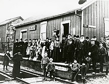
The land (west of what is now Preston), including Carolinian forest, that would eventually become Blair was purchased from the Six Nations, through land speculator Richard Beasley. It was settled in 1800 by Samuel D. Betzner, one of the Mennonites from Pennsylvania. The group later discovered that Beasley had gotten into financial trouble and that a lien was placed on the lands. To solve the problem, the group created the German Company that bought an additional 60,000 acres of land from Beasley, who used the proceeds to pay off the debt on the previous lands. This ensured a clear title for the Mennonite group.
The first school in what later became Waterloo County opened in 1802 near Blair, then known as Shinglebridge. The first teacher's name was Mr. Rittenhaus.[35][36]
By 1804, the first cemetery in Waterloo County had been founded. Also located in Blair, it is often referred to as the Old Blair Cemetery or the Old Blair Memorial Cemetery.[36] The first recorded burial was of an infant, the son of Mennonite settler John Bricker,[37] who died on March 10 of that year.[38]
Joseph Bowman, a man called Wismer and John Bechtel were responsible for the early development of the community in an area laid out by Benjamin B. Bowman. They built a dam, then a sawmill and grist mill. In 1846, a large flour mill opened, which was called the Bowman Mill, Blair Mill and also the Carlisle Mill.[8] In about 1876, a 15-horsepower hydroelectric system, the Sheave Tower, was built on Bowman Creek by Allan Bowman to help power the flour mill using a series of shafts and gears. This was a significant achievement in that era.[39]
Although the name Carlisle (or New Carlisle) was commonly used then, the name Blair was chosen for the first post office in 1858 because a village of Carlisle had already been established in Halton County. The new name honoured Adam Johnston Fergusson Blair, the first judge of Wellington District and a militia colonel in the area. In addition to Carlisle, earlier names for the village had included Shinglebridge, because a bridge with a shingle roof crossed the Grand River in this area from 1853 to 1857.[40] It was also called Durham (or Durhamville) and Lambs' Bridge.
By 1864, the settlement was receiving mail daily, had a large school, a Mennonite meeting house, a large brick church and a population of 200. Railway service arrived in Blair in 1873[41] when the Grand Trunk Railway, having acquired the Great Western Railway's defunct Preston and Berlin Railway, rerouted it through Blair on its way to Galt, bypassing Preston, the railway's original destination.[42]
Blair became part of Preston in 1969. Many historic buildings still stand in the village, including some from the early 1820s. This includes the Sheave Tower (restored in 1999) and the John Bechtel residence.[43]
Galt, Preston and Hespeler Electric Railway
A new electric street railway system, the Galt, Preston and Hespeler Street Railway (later called the Grand River Railway Company) began to operate in 1894, initially connecting Preston and Galt. In 1911, the line reached Hespeler, Berlin (later called Kitchener) and Waterloo; by 1916 it had been extended to Brantford/Port Dover.[15][16] The electric rail system ended passenger services in April 1955. The light rail transit plan for the Regional Municipality of Waterloo, decades later, would be reminiscent of the original Electric Railway.[15]
Government
The first mayor of Cambridge, taking office as of the city's creation in 1973, was Claudette Millar. Most recently, Kathryn McGarry was elected in the 2018 municipal election to succeed Doug Craig as the city's sixth mayor, taking office on December 1, 2018.
Cambridge City Council consists of the mayor and eight councillors, each representing a ward.
A referendum question asking municipal electors if they wished to change to ranked voting was approved on October 23, 2018.[44]
In 2020, Scott Hamilton was elected in a by-election for Ward 7 to replace Councillor Frank Monteiro who passed while serving the community.[45]
City councillors by ward:
- Ward 1: Donna Reid
- Ward 2: Mike Devine
- Ward 3: Mike Mann
- Ward 4: Jan Liggett
- Ward 5: Pam Wolf
- Ward 6: Shannon Adshade
- Ward 7: Scott Hamilton
- Ward 8: Nicholas Ermeta
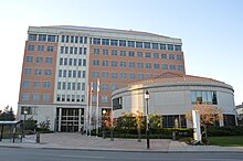
Cambridge is also represented on the higher-tier Waterloo Regional Council which consists of the regional chair, the mayors of the seven cities and townships, and eight additional councillors - four from Kitchener and two each from Cambridge and Waterloo. Ken Seiling has held the position of regional chair from 1985-November 30, 2018.[46][47] In the 2018 Region of Waterloo elections, Karen Redman was elected as Regional Chair.
The City of Cambridge is represented by:
- Cambridge Mayor Kathryn McGarry
- Regional Councillor Karl Kiefer
- Regional Councillor Helen Jowett
| Year | Liberal | Conservative | New Democratic | Green | |||||
|---|---|---|---|---|---|---|---|---|---|
| 2021 | 38% | 23,522 | 34% | 20,820 | 17% | 10,529 | 3% | 1,979 | |
| 2019 | 40% | 25,995 | 30% | 19,757 | 19% | 12,220 | 8% | 5,242 | |
| Year | PC | New Democratic | Liberal | Green | |||||
|---|---|---|---|---|---|---|---|---|---|
| 2022 | 37% | 16,048 | 23% | 9,978 | 20% | 8,651 | 9% | 4,042 | |
| 2018 | 37% | 20,119 | 33% | 17,830 | 22% | 11,564 | 7% | 3,623 | |
Cambridge (federal electoral district) is represented in Ottawa by Bryan May (Liberal), the federal member of Parliament who defeated the previous incumbent MP (Gary Goodyear, Conservative – 2004 to 2015) in the October 2015 election. The second federal representative for Cambridge is Valerie Bradford (Liberal), who represents the federal riding of Kitchener South—Hespeler.
The MPP for the provincial district of Cambridge is Brian Riddell (Progressive Conservative Party of Ontario), who defeated New Blue Party of Ontario co-founder Belinda Karahalios in 2022. The second provincial representative for Cambridge is Jess Dixon (Progressive Conservative), who represents the provincial riding of Kitchener South—Hespeler.
Municipal services
The city is responsible for Community Services, Economic Development, Transportation & Public Works, Corporate Services, Fire Department and Planning Services. Many municipal services are provided through the Regional Municipality of Waterloo (often referred to as Waterloo Region or the Region of Waterloo), which consists of the cities of Cambridge, Kitchener, and Waterloo, and the townships of Woolwich, Wilmot, Wellesley, and North Dumfries. The region of Waterloo responsibilities includes Social Services, Community Health Services, Grand River Transit and Community Policing through Waterloo Regional Police Service.
Hospital
Hospital services are provided by Cambridge Memorial Hospital at 700 Coronation Boulevard. A small hospital in the Galt area had opened in 1890, the first in Waterloo County,[50] while the current facility, originally named South Waterloo Memorial Hospital, was completed in 1953. It was expanded in the early 1970s with the addition of Wing B, the inpatient tower.[51] This facility began a $187 million expansion project in 2014 that was expected to be completed by 2019. The hospital summarized the plan as follows in 2013: "This transformation includes a larger Emergency Department and a 33% increase in beds to accommodate expanded mental health, medicine, surgery, birthing programs and so much more".[51]
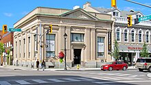
Difficulties with the general contractor, Bondfield Construction, which eventually went into receivership, delayed the process significantly. A news report on 29 December 2018 stated that "After two decades of planning and community fundraising, the expansion project, promising 54 new beds and a twice-as-large emergency department, is not quite half-complete and stalled". A consortium of banks, led by the receiver, the Bank of Montreal, called on the contractor's insurer, Zurich, to activate its surety bond.[52] That step provided the funding to continue work on the new wing to correct the many deficiencies; the process was moving slowly as of late April 2019. At that time, Infrastructure Ontario, Zurich Insurance Company and the project lenders were in discussions with a contractor who will be hired to renovate the existing B wing after the new wing is occupied. An estimate in late 2018 indicated that the completion date for the entire hospital project was 2021 at the earliest.[53] [54]
Part of the hospital expansion, the new patient care wing, was completed in mid-November 2019 and was scheduled to open in January 2020, after new equipment has been installed and staff have been trained.[55]
Climate
The climate in Cambridge is typical of southwestern Ontario, and has a humid continental climate under the Köppen climate classification (Köppen Dfb) with mostly moderate winters but the occasional deep freeze. In summer, the temperatures tend to be in the high twenties on the Celsius scale, and like most of southern Ontario, there can be stretches of high humidity creating some discomfort. On most days, Cambridge tends to be slightly warmer than Kitchener and Guelph, just to the north.[citation needed]
The last frost date of the season is around May 11,[56] though most gardeners plant on the May 24 long weekend to be safe. Environment Canada issues frost warnings for the area from October 30 through to May 9.[57][58]
| Climate data for Cambridge, Ontario (1981−2010) | |||||||||||||
|---|---|---|---|---|---|---|---|---|---|---|---|---|---|
| Month | Jan | Feb | Mar | Apr | May | Jun | Jul | Aug | Sep | Oct | Nov | Dec | Year |
| Record high °C (°F) | 17.8 (64.0) |
14.4 (57.9) |
24.0 (75.2) |
30.0 (86.0) |
35.0 (95.0) |
36.0 (96.8) |
37.8 (100.0) |
37.8 (100.0) |
37.2 (99.0) |
32.2 (90.0) |
25.0 (77.0) |
19.5 (67.1) |
37.8 (100.0) |
| Mean daily maximum °C (°F) | −1.7 (28.9) |
−0.8 (30.6) |
4.2 (39.6) |
12.3 (54.1) |
19.0 (66.2) |
23.9 (75.0) |
26.7 (80.1) |
25.1 (77.2) |
20.3 (68.5) |
13.7 (56.7) |
6.8 (44.2) |
0.6 (33.1) |
12.5 (54.5) |
| Daily mean °C (°F) | −6 (21) |
−5.5 (22.1) |
−0.9 (30.4) |
6.8 (44.2) |
12.8 (55.0) |
17.6 (63.7) |
20.6 (69.1) |
19.4 (66.9) |
14.6 (58.3) |
8.4 (47.1) |
2.8 (37.0) |
−3.2 (26.2) |
7.3 (45.1) |
| Mean daily minimum °C (°F) | −10.2 (13.6) |
−10.1 (13.8) |
−6.0 (21.2) |
1.2 (34.2) |
6.6 (43.9) |
11.3 (52.3) |
14.4 (57.9) |
13.5 (56.3) |
8.9 (48.0) |
3.0 (37.4) |
−1.1 (30.0) |
−7.1 (19.2) |
2.1 (35.8) |
| Record low °C (°F) | −35.6 (−32.1) |
−31.7 (−25.1) |
−30.0 (−22.0) |
−15.6 (3.9) |
−5.0 (23.0) |
−0.6 (30.9) |
4.4 (39.9) |
1.0 (33.8) |
−3.9 (25.0) |
−10.0 (14.0) |
−20.0 (−4.0) |
−28.5 (−19.3) |
−35.6 (−32.1) |
| Average precipitation mm (inches) | 55.4 (2.18) |
47.4 (1.87) |
50.2 (1.98) |
71.3 (2.81) |
84.2 (3.31) |
74.1 (2.92) |
111.6 (4.39) |
91.5 (3.60) |
86.9 (3.42) |
71.9 (2.83) |
86.8 (3.42) |
74.0 (2.91) |
905.2 (35.64) |
| Average rainfall mm (inches) | 18.1 (0.71) |
18.1 (0.71) |
35.4 (1.39) |
68.9 (2.71) |
84.2 (3.31) |
74.1 (2.92) |
111.6 (4.39) |
91.5 (3.60) |
86.9 (3.42) |
71.0 (2.80) |
81.3 (3.20) |
44.3 (1.74) |
785.4 (30.92) |
| Average snowfall cm (inches) | 37.8 (14.9) |
29.3 (11.5) |
14.8 (5.8) |
2.4 (0.9) |
0.0 (0.0) |
0.0 (0.0) |
0.0 (0.0) |
0.0 (0.0) |
0.0 (0.0) Zdroj:https://en.wikipedia.org?pojem=Cambridge,_Ontario Text je dostupný za podmienok Creative Commons Attribution/Share-Alike License 3.0 Unported; prípadne za ďalších podmienok. Podrobnejšie informácie nájdete na stránke Podmienky použitia.
Analytika
Antropológia Aplikované vedy Bibliometria Dejiny vedy Encyklopédie Filozofia vedy Forenzné vedy Humanitné vedy Knižničná veda Kryogenika Kryptológia Kulturológia Literárna veda Medzidisciplinárne oblasti Metódy kvantitatívnej analýzy Metavedy Metodika Text je dostupný za podmienok Creative
Commons Attribution/Share-Alike License 3.0 Unported; prípadne za ďalších
podmienok. www.astronomia.sk | www.biologia.sk | www.botanika.sk | www.dejiny.sk | www.economy.sk | www.elektrotechnika.sk | www.estetika.sk | www.farmakologia.sk | www.filozofia.sk | Fyzika | www.futurologia.sk | www.genetika.sk | www.chemia.sk | www.lingvistika.sk | www.politologia.sk | www.psychologia.sk | www.sexuologia.sk | www.sociologia.sk | www.veda.sk I www.zoologia.sk | ||||


