A | B | C | D | E | F | G | H | CH | I | J | K | L | M | N | O | P | Q | R | S | T | U | V | W | X | Y | Z | 0 | 1 | 2 | 3 | 4 | 5 | 6 | 7 | 8 | 9

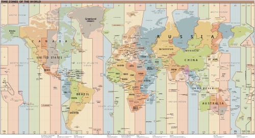
A time zone is an area which observes a uniform standard time for legal, commercial and social purposes. Time zones tend to follow the boundaries between countries and their subdivisions instead of strictly following longitude, because it is convenient for areas in frequent communication to keep the same time.
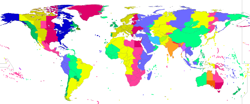
Each time zone is defined by a standard offset from Coordinated Universal Time (UTC). The offsets range from UTC−12:00 to UTC+14:00, and are usually a whole number of hours, but a few zones are offset by an additional 30 or 45 minutes, such as in India and Nepal. Some areas in a time zone may use a different offset for part of the year, typically one hour ahead during spring and summer, a practice known as daylight saving time (DST).
List of UTC offsets

In the table below, the locations that use daylight saving time (DST) are listed in their UTC offset when DST is not in effect. When DST is in effect, approximately during spring and summer, their UTC offset is increased by one hour (except for Lord Howe Island, where it is increased by 30 minutes). For example, during the DST period California observes UTC−07:00 and the United Kingdom observes UTC+01:00.
History
The apparent position of the Sun in the sky, and thus solar time, varies by location due to the spherical shape of the Earth. This variation corresponds to four minutes of time for every degree of longitude, so for example when it is solar noon in London, it is about 10 minutes before solar noon in Bristol, which is about 2.5 degrees to the west.[6]
The Royal Observatory, Greenwich, founded in 1675, established Greenwich Mean Time (GMT), the mean solar time at that location, as an aid to mariners to determine longitude at sea, providing a standard reference time while each location in England kept a different time.
Railway time


In the 19th century, as transportation and telecommunications improved, it became increasingly inconvenient for each location to observe its own solar time. In November 1840, the British Great Western Railway started using GMT kept by portable chronometers.[7][failed verification] This practice was soon followed by other railway companies in Great Britain and became known as Railway Time.
Around August 23, 1852, time signals were first transmitted by telegraph from the Royal Observatory. By 1855, 98% of Great Britain's public clocks were using GMT, but it was not made the island's legal time until August 2, 1880. Some British clocks from this period have two minute hands, one for the local time and one for GMT.[8]
On November 2, 1868, the then British Colony of New Zealand officially adopted a standard time to be observed throughout the colony.[9] It was based on longitude 172°30′ east of Greenwich, that is 11 hours 30 minutes ahead of GMT. This standard was known as New Zealand Mean Time.[10]

Timekeeping on North American railroads in the 19th century was complex. Each railroad used its own standard time, usually based on the local time of its headquarters or most important terminus, and the railroad's train schedules were published using its own time. Some junctions served by several railroads had a clock for each railroad, each showing a different time.[11]
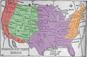
Around 1863, Charles F. Dowd proposed a system of hourly standard time zones for North American railroads, although he published nothing on the matter at that time and did not consult railroad officials until 1869. In 1870 he proposed four ideal time zones having north–south borders, the first centered on Washington, D.C., but by 1872 the first was centered on meridian 75° west of Greenwich, with natural borders such as sections of the Appalachian Mountains. Dowd's system was never accepted by North American railroads. Chief meteorologist at the United States Weather Bureau Cleveland Abbe divided the United States into four standard time zones for consistency among the weather stations. In 1879, he published a paper titled Report on Standard Time.[12] In 1883, he convinced North American railroad companies to adopt his time-zone system. In 1884, Britain, which had already adopted its own standard time system for England, Scotland, and Wales, helped gather international consent for global time. In time, the American government, influenced in part by Abbe's 1879 paper, adopted the time-zone system.[13] It was a version proposed by William F. Allen, the editor of the Traveler's Official Railway Guide.[14] The borders of its time zones ran through railroad stations, often in major cities. For example, the border between its Eastern and Central time zones ran through Detroit, Buffalo, Pittsburgh, Atlanta, and Charleston. It was inaugurated on Sunday, November 18, 1883, also called "The Day of Two Noons",[15] when each railroad station clock was reset as standard-time noon was reached within each time zone.
The North American zones were named Intercolonial, Eastern, Central, Mountain, and Pacific. Within a year 85% of all cities with populations over 10,000 (about 200 cities) were using standard time.[16] A notable exception was Detroit (located about halfway between the meridians of Eastern and Central time), which kept local time until 1900, then tried Central Standard Time, local mean time, and Eastern Standard Time (EST) before a May 1915 ordinance settled on EST and was ratified by popular vote in August 1916. The confusion of times came to an end when standard time zones were formally adopted by the U.S. Congress in the Standard Time Act of March 19, 1918.
Worldwide time zones
Italian mathematician Quirico Filopanti introduced the idea of a worldwide system of time zones in his book Miranda!, published in 1858. He proposed 24 hourly time zones, which he called "longitudinal days", the first centred on the meridian of Rome. He also proposed a universal time to be used in astronomy and telegraphy. However, his book attracted no attention until long after his death.[17][18]
Scottish-born Canadian Sir Sandford Fleming proposed a worldwide system of time zones in 1876 - see Sandford Fleming § Inventor of worldwide standard time. The proposal divided the world into twenty-four time zones labeled A-Y (skipping J), each one covering 15 degrees of longitude. All clocks within each zone would be set to the same time as the others, but differed by one hour from those in the neighboring zones.[19] He advocated his system at several international conferences, including the International Meridian Conference, where it received some consideration. The system has not been directly adopted, but some maps divide the world into 24 time zones and assign letters to them, similarly to Fleming's system.[20]

By about 1900, almost all inhabited places on Earth had adopted a standard time zone, but only some of them used an hourly offset from GMT. Many applied the time at a local astronomical observatory to an entire country, without any reference to GMT. It took many decades before all time zones were based on some standard offset from GMT or Coordinated Universal Time (UTC). By 1929, the majority of countries had adopted hourly time zones, though some countries such as Iran, India, Myanmar and parts of Australia had time zones with a 30-minute offset. Nepal was the last country to adopt a standard offset, shifting slightly to UTC+05:45 in 1986.[21]
All nations currently use standard time zones for secular purposes, but not all of them apply the concept as originally conceived. Several countries and subdivisions use half-hour or quarter-hour deviations from standard time. Some countries, such as China and India, use a single time zone even though the extent of their territory far exceeds the ideal 15° of longitude for one hour; other countries, such as Spain and Argentina, use standard hour-based offsets, but not necessarily those that would be determined by their geographical location. The consequences, in some areas, can affect the lives of local citizens, and in extreme cases contribute to larger political issues, such as in the western reaches of China.[22] In Russia, which has 11 time zones, two time zones were removed in 2010[23][24] and reinstated in 2014.[25]
Notation
ISO 8601
ISO 8601 is a standard established by the International Organization for Standardization defining methods of representing dates and times in textual form, including specifications for representing time zones.
If a time is in Coordinated Universal Time (UTC), a "Z" is added directly after the time without a separating space. "Z" is the zone designator for the zero UTC offset. "09:30 UTC" is therefore represented as "09:30Z" or "0930Z". Likewise, "14:45:15 UTC" is written as "14:45:15Z" or "144515Z".[26] UTC time is also known as "Zulu" time, since "Zulu" is a phonetic alphabet code word for the letter "Z".[26]
Offsets from UTC are written in the format ±hh:mm, ±hhmm, or ±hh (either hours ahead or behind UTC). For example, if the time being described is one hour ahead of UTC (such as the time in Germany during the winter), the zone designator would be "+01:00", "+0100", or simply "+01". This numeric representation of time zones is appended to local times in the same way that alphabetic time zone abbreviations (or "Z", as above) are appended. The offset from UTC changes with daylight saving time, e.g. a time offset in Chicago, which is in the North American Central Time Zone, is "−06:00" for the winter (Central Standard Time) and "−05:00" for the summer (Central Daylight Time).[27]
Abbreviations
Time zones are often represented by alphabetic abbreviations such as "EST", "WST", and "CST", but these are not part of the international time and date standard ISO 8601. Such designations can be ambiguous; for example, "CST" can mean (North American) Central Standard Time (UTC−06:00), Cuba Standard Time (UTC−05:00) and China Standard Time (UTC+08:00), and it is also a widely used variant of ACST (Australian Central Standard Time, UTC+09:30).[28]
Conversions
Conversion between time zones obeys the relationship
- "time in zone A" − "UTC offset for zone A" = "time in zone B" − "UTC offset for zone B",
in which each side of the equation is equivalent to UTC.
The conversion equation can be rearranged to
- "time in zone B" = "time in zone A" − "UTC offset for zone A" + "UTC offset for zone B".
For example, the New York Stock Exchange opens at 09:30 (EST, UTC offset= −05:00). In California (PST, UTC offset= −08:00) and India (IST, UTC offset= +05:30), the New York Stock Exchange opens at
- time in California = 09:30 − (−05:00) + (−08:00) = 06:30;
- time in India = 09:30 − (−05:00) + (+05:30) = 20:00.
These calculations become more complicated near the time switch to or from daylight saving time, as the UTC offset for the area becomes a function of UTC time.
The time differences may also result in different dates. For example, when it is 22:00 on Monday in Egypt (UTC+02:00), it is 01:00 on Tuesday in Pakistan (UTC+05:00).
The table "Time of day by zone" gives an overview on the time relations between different zones.
| Time of day by zone | ||||||||||||||||||||||||
|---|---|---|---|---|---|---|---|---|---|---|---|---|---|---|---|---|---|---|---|---|---|---|---|---|
| UTC offset | Monday | |||||||||||||||||||||||
| UTC−12:00 | 00:00 | 01:00 | 02:00 | 03:00 | 04:00 | 05:00 | 06:00 | 07:00 | 08:00 | 09:00 | 10:00 | 11:00 | 12:00 | 13:00 | 14:00 | 15:00 | 16:00 | 17:00 | 18:00 | 19:00 | 20:00 | 21:00 | 22:00 | 23:00 |
| UTC−11:00 | 01:00 | 02:00 | 03:00 | 04:00 | 05:00 | 06:00 | 07:00 | 08:00 | 09:00 | 10:00 | 11:00 | 12:00 | 13:00 | 14:00 | 15:00 | 16:00 | 17:00 | 18:00 | 19:00 | 20:00 | 21:00 | 22:00 | 23:00 | 00:00 |
| UTC−10:00 | 02:00 | 03:00 | 04:00 | 05:00 | 06:00 | 07:00 | 08:00 | 09:00 | 10:00 | 11:00 | 12:00 | 13:00 | 14:00 | 15:00 | 16:00 | 17:00 | 18:00 | 19:00 | 20:00 | 21:00 | 22:00 | 23:00 | 00:00 | 01:00 |
| UTC−09:30 | 02:30 | 03:30 | 04:30 | 05:30 | 06:30 | 07:30 | 08:30 | 09:30 | 10:30 | 11:30 | 12:30 | 13:30 | 14:30 | 15:30 | 16:30 | 17:30 | 18:30 | 19:30 | 20:30 | 21:30 | 22:30 | 23:30 | 00:30 | 01:30 |
| UTC−09:00 | 03:00 | 04:00 | 05:00 | 06:00 | 07:00 | 08:00 | 09:00 | 10:00 | 11:00 | 12:00 | 13:00 | 14:00 | 15:00 | 16:00 | 17:00 | 18:00 | 19:00 | 20:00 | 21:00 | 22:00 | 23:00 | 00:00 | 01:00 | 02:00 |
| UTC−08:00 | 04:00 | 05:00 | 06:00 | 07:00 | 08:00 | 09:00 | 10:00 | 11:00 | 12:00 | 13:00 | 14:00 | 15:00 | 16:00 | 17:00 | 18:00 | 19:00 | Zdroj:https://en.wikipedia.org?pojem=Time_zone||||||||
