

A | B | C | D | E | F | G | H | CH | I | J | K | L | M | N | O | P | Q | R | S | T | U | V | W | X | Y | Z | 0 | 1 | 2 | 3 | 4 | 5 | 6 | 7 | 8 | 9
You can help expand this article with text translated from the corresponding article in Japanese. (February 2022) Click for important translation instructions.
|
Niigata
新潟市 | |||||||||
|---|---|---|---|---|---|---|---|---|---|
| Niigata City | |||||||||
| |||||||||
 Flag  Seal | |||||||||
 | |||||||||
 Location of Niigata in Niigata Prefecture | |||||||||
 Niigata | |||||||||
| Coordinates: 37°54′58″N 139°2′11″E / 37.91611°N 139.03639°E | |||||||||
| Country | Japan | ||||||||
| Region | Chūbu (Kōshin'etsu) (Hokuriku) | ||||||||
| Prefecture | Niigata | ||||||||
| City Status | April 1, 1889[citation needed] city incorporation ) | ||||||||
| Government | |||||||||
| • Mayor | Yaichi Nakahara (from November, 2018) | ||||||||
| Area | |||||||||
| • Designated city | 726.45 km2 (280.48 sq mi) | ||||||||
| Population (July 1, 2019) | |||||||||
| • Designated city | 797,591 | ||||||||
| • Density | 1,100/km2 (2,800/sq mi) | ||||||||
| • Metro [1] (2015) | 1,060,013 (17th) | ||||||||
| Time zone | UTC+9 (Japan Standard Time) | ||||||||
| Phone number | 025-243-4894 | ||||||||
| Address | 1-602-1 Gakkōchō-dōri, Chūō-ku, Niigata-shi, Niigata-ken 951-8550 | ||||||||
| Climate | Cfa | ||||||||
| Website | city.niigata.lg.jp | ||||||||
| Symbols | |||||||||
| Bird | Swan | ||||||||
| Flower | Tulip | ||||||||
| Tree | Willow | ||||||||


| Niigata | |||||
|---|---|---|---|---|---|
"Niigata" in kanji | |||||
| Japanese name | |||||
| Kanji | 新潟 | ||||
| |||||
Niigata (新潟市, Niigata-shi, [niːɡata]) is a city located in the northern part of Niigata Prefecture. It is the capital and the most populous city of Niigata Prefecture, and one of the cities designated by government ordinance of Japan, located in the Chūbu region of Japan. It is the most populous city on the west coast of Honshu, and the second populous city in Chūbu region after Nagoya. It faces the Sea of Japan and Sado Island. As of 1 September 2022[update], the city had an estimated population of 779,049, and a population density of 1,072 persons per km2. The total area is 726.45 square kilometres (280.48 sq mi). Greater Niigata, the Niigata Metropolitan Employment Area, has a GDP of US$43.3 billion as of 2010.[2][3]
It is the only government-designated city on the west coast of Honshu. It has the greatest habitable area of cities in Japan.
Overviewedit
Niigata was one of the cities incorporated by the legislation effective on April 1, 1889 (Meiji 22). With a long history as a port town, Niigata served the function of the network junction between the maritime traffic and those of Shinano and Agano river systems. It was designated as one of the five free Treaty ports under Treaty of Amity and Commerce (United States-Japan) signed in 1858, just before the Meiji Restoration, later started operations in 1869. Its importance in land and water transportation is still current.
Niigata's city government was established in 1889. Mergers with nearby municipalities in 2005 allowed the city's population to jump to 810,000. The annexation of the surrounding area has also given the city the greatest rice paddy field acreage in Japan. On April 1, 2007, it became the first government-designated city on the coast of the Sea of Japan of Honshu. There are 8 wards (described later) in the city.
Until the 1950s, a system of canals were lined along by the willow trees in the downtown area of Niigata. Therefore the city is sometimes called the "City of Water" or "City of Willows" as detailed later. Niigata produced many manga artists (see: Artists and writers). It is also known to have an extensive network of bypass roads. Bandai bridge, NEXT21, Toki Messe, Denka Big Swan Stadium, Niigata Nippo Media Ship are considered to be the key symbol landmarks in the city (see: Local attractions).
Toponymyedit
The place name "Niigata" was first recorded in 1520 (Eisho 17).[4] Its name in kanji can be translated as 新 "new" and 潟 "lagoon".
However, as there is no record about the origin of the name, this had led to many theories.
- First "Niigata" was a large lagoon at the mouth of the Shinano river.
- Second it was an inland bay at the river's entrance.
- Third it was the name of a village that stood on an island within the estuary.
- Fourth it referred to another settlement that relocated to the Furumachi district and that in turn gave its name to a nearby lagoon.[5]
Cityscapesedit

-
 CBD of Niigata City (2012)
 -

-
 Toki Messe (2021)
 -
 River Front Park (2021)
 -
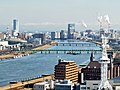 A view of Niigata City and Shinano River from observation deck of Niigata Prefecture Building (2022)
 -
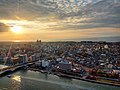 Sunset of Niigata City (2022)


Geographyedit
Niigata is situated on a fertile coastal plain on the Sea of Japan coast, facing Sado Island. The Shinano River and Agano River flow through the city.
Numerous wetlands, such as the Fukushimagata wetlands, can be found within the city limits. The Sakata lagoon is registered as a wetland of international importance under the Ramsar Convention.
Niigata City's low elevation and abundant water have made flood control and land reclamation important issues for the area throughout its history.
The city is sometimes called the "City of Water" (水の都, Mizu-no-miyako) because of the two rivers that flow through it, its position next to the Sea of Japan, its many wetlands, and the canals that used to run through the city. It is also sometimes referred to as the "City of Willows" (柳の都, Yanagi-no-miyako) or Ryuto (柳都) because of the willow trees that lined the old canals. In recent years, the city has been promoting itself as a "Designated City of Food and Flowers" (食と花の政令市, Shoku to hana no seireishi), highlighting its agricultural areas outside of the city center.
-
 Aerial photo of Niigata
 -
 View of Echigo Plain from Mount Kakuda
 -
 Lake Fukushimagata
 -
 Lake Sakata


Climateedit
Niigata City features a humid subtropical climate (Cfa). However, due to high precipitation, it receives more yearly snowfall than cities with continental climates such as Moscow, Montreal or Oslo. Winters are characterized by their high humidity and strong winds from the Sea of Japan. While many other parts of Niigata Prefecture tend to have heavy snow, Niigata City itself usually receives less due to its low-lying elevation and the shielding effect of Sado Island.
On average, Niigata City has 269 days of precipitation each year, about 170 days of which see rain or snowfall measuring over 1 mm.[6] The rainy season in July brings large amounts of rain, while the winter months, especially November and December, also have much precipitation.[7]
In summer, the south wind makes the weather rather hot.[citation needed] Typhoons usually bring strong foehn winds to this area, generally causing somewhat higher temperatures than in other parts of Japan.[citation needed] The weather on the west coast of Honshu tends to be better during the summer months than on the Pacific coast.[citation needed]
| Climate data for Niigata (1991−2020 normals, extremes 1881−present) | |||||||||||||
|---|---|---|---|---|---|---|---|---|---|---|---|---|---|
| Month | Jan | Feb | Mar | Apr | May | Jun | Jul | Aug | Sep | Oct | Nov | Dec | Year |
| Record high °C (°F) | 15.3 (59.5) |
21.3 (70.3) |
25.1 (77.2) |
30.7 (87.3) |
32.9 (91.2) |
35.0 (95.0) |
38.5 (101.3) |
39.9 (103.8) |
38.8 (101.8) |
33.3 (91.9) |
27.2 (81.0) |
23.6 (74.5) |
39.9 (103.8) |
| Mean daily maximum °C (°F) | 5.3 (41.5) |
6.4 (43.5) |
10.3 (50.5) |
16.1 (61.0) |
21.3 (70.3) |
24.8 (76.6) |
28.7 (83.7) |
30.8 (87.4) |
26.4 (79.5) |
20.7 (69.3) |
14.3 (57.7) |
8.7 (47.7) |
17.8 (64.0) |
| Daily mean °C (°F) | 2.5 (36.5) |
3.1 (37.6) |
6.2 (43.2) |
11.3 (52.3) |
16.7 (62.1) |
20.9 (69.6) |
24.9 (76.8) |
26.5 (79.7) |
22.5 (72.5) |
16.7 (62.1) |
10.5 (50.9) |
5.3 (41.5) |
13.9 (57.0) |
| Mean daily minimum °C (°F) | 0.1 (32.2) |
−0.1 (31.8) |
2.4 (36.3) |
7.0 (44.6) |
12.7 (54.9) |
17.7 (63.9) |
21.8 (71.2) |
23.3 (73.9) |
19.0 (66.2) |
12.8 (55.0) |
6.9 (44.4) |
2.4 (36.3) |
10.5 (50.9) |
| Record low °C (°F) | −11.7 (10.9) |
−13.0 (8.6) |
−6.4 (20.5) |
−2.5 (27.5) |
2.0 (35.6) |
6.7 (44.1) |
11.4 (52.5) |
14.5 (58.1) |
7.9 (46.2) |
3.0 (37.4) |
−1.8 (28.8) |
−9.5 (14.9) |
−13.0 (8.6) |
| Average precipitation mm (inches) | 180.9 (7.12) |
115.8 (4.56) |
112.0 (4.41) |
97.2 (3.83) |
94.4 (3.72) |
121.1 (4.77) |
222.3 (8.75) |
163.4 (6.43) |
151.9 (5.98) |
157.7 (6.21) |
203.5 (8.01) |
225.9 (8.89) |
1,845.9 (72.67) |
| Average snowfall cm (inches) | 63 (25) |
48 (19) |
8 (3.1) |
0 (0) |
0 (0) |
0 (0) |
0 (0) |
0 (0) |
0 (0) |
0 (0) |
0 (0) |
19 (7.5) |
139 (55) |
| Average precipitation days (≥ 0.5 mm) | 23.3 | 19.0 | 17.4 | 13.3 | 11.3 | 10.6 | 13.6 | 10.9 | 13.5 | 15.2 | Zdroj:https://en.wikipedia.org?pojem=Niigata,_Niigata|||