

A | B | C | D | E | F | G | H | CH | I | J | K | L | M | N | O | P | Q | R | S | T | U | V | W | X | Y | Z | 0 | 1 | 2 | 3 | 4 | 5 | 6 | 7 | 8 | 9
You can help expand this article with text translated from the corresponding article in Japanese. (December 2016) Click for important translation instructions.
|
This article needs additional citations for verification. (May 2022) |
Niigata Prefecture
新潟県 | |
|---|---|
| Japanese transcription(s) | |
| • Japanese | 新潟県 |
| • Rōmaji | Niigata-ken |
 Flag  Symbol | |
| Anthem: Niigata kenminka | |
 | |
| Country | |
| Region | Chūbu (Kōshinetsu) (Hokuriku) |
| Island | Honshu |
| Capital | Niigata |
| Subdivisions | Districts: 9, Municipalities: 30 |
| Government | |
| • Governor | Hideyo Hanazumi |
| Area | |
| • Total | 12,584.18 km2 (4,858.78 sq mi) |
| • Rank | 5th |
| Population (July 1, 2023) | |
| • Total | 2,131,009 |
| • Rank | 14th |
| • Density | 170/km2 (440/sq mi) |
| GDP | |
| • Total | JP¥ 9,185 billion US$ 84.3 billion (2019) |
| ISO 3166 code | JP-15 |
| Website | www |
| Symbols of Japan | |
| Bird | Crested ibis (Nipponia nippon) |
| Flower | Tulip (Tulipa gesneriana) |
| Tree | Camellia (Camellia japonica) |
.jpg)


Niigata Prefecture (新潟県, Niigata-ken) is a prefecture in the Chūbu region of Honshu of Japan.[2] Niigata Prefecture has a population of 2,131,009 (1 July 2023) and is the fifth-largest prefecture of Japan by geographic area at 12,584.18 km2 (4,858.78 sq mi). Niigata Prefecture borders Toyama Prefecture and Nagano Prefecture to the southwest, Gunma Prefecture to the south, Fukushima Prefecture to the east, and Yamagata Prefecture to the northeast.
Niigata is the capital and largest city of Niigata Prefecture, with other major cities including Nagaoka, Jōetsu, and Sanjō.[3] Niigata Prefecture contains the Niigata Major Metropolitan Area centered on Niigata with a population of 1,395,612, the largest metropolitan area on the Sea of Japan coast and the twelfth-largest in Japan. Niigata Prefecture is part of the historic Hokuriku region and features Sado Island, the sixth largest island of Japan in area following the four main islands and Okinawa Island.
Historyedit

Until after the Meiji Restoration, the area that is now Niigata Prefecture was divided into Echigo Province (on the mainland) and Sado Province.[4] During the Sengoku period, the Nagao clan, who were at times vassals to the Uesugi, ruled a fief in the western part of modern Niigata from Kasugayama Castle. The most notable member of the Nagao clan was Nagao Kagetora, later and better known as Uesugi Kenshin. He unified the leaders of Echigo Province and became its sole ruler. By taking the surname Uesugi, he also became the head of the Uesugi clan and effectively brought their realm under his control.
The city of Niigata is now the third largest Japanese city facing the Sea of Japan, after Fukuoka and Kitakyushu. It was the first Japanese port on the Sea of Japan to be opened to foreign trade following the opening of Japan by Matthew Perry. It has since played an important role in trade with Russia and Korea. A freighter from North Korea visits Niigata once a month, in one of the few forms of direct contact between Japan and that country.
The Etsuzankai organization, led by the politician Kakuei Tanaka, was highly influential in bringing infrastructure improvements to Niigata Prefecture in the 1960s and 1970s. These included the Jōetsu Shinkansen high-speed rail line and the Kanetsu Expressway to Tokyo.
On October 23, 2004, the Chūetsu earthquake struck Niigata Prefecture and was measured at Shindo 6+ at Ojiya.
On January 9, 2006, a heavy winter storm struck the prefecture and its neighbors. At least 71 people died and more than 1,000 were injured. Also in 2006, a massive tsunami and earthquake damaged homes and caused casualties in the maritime areas of Niigata Prefecture, especially near Sado Island.
On July 16, 2007, another earthquake hit the area.
Niigata Prefecture hosts the Fuji Rock Festival, an annual event held at the Naeba ski resort. The three-day event, organized by Smash Japan, features more than 200 Japanese and international musicians. It is one of the largest outdoor music events in Japan, with more than 100,000 people attending in 2005.
Geographyedit

Government Ordinance Designated City City Town Village


Niigata Prefecture stretches about 240 km (149 mi) along the Sea of Japan, from the southwest to the northeast, with a coastal plain between the mountains and the sea. It also includes Sado Island. Niigata Prefecture could be placed in either the Hokuriku or the Kōshinetsu, both of which are considered parts of the Chūbu region. The prefecture is generally divided into four geographical areas: Jōetsu region (上越) in the south, Chūetsu (中越) in the center, Kaetsu (下越) in the north, and Sado Island. The mouth of the Shinano River, the longest river in Japan, is located in Niigata Prefecture.
As of 1 April 2014, 25% of the total land area of the prefecture was designated as Natural Parks, namely Bandai-Asahi, Chūbu-Sangaku, Nikkō, and Oze National Parks; Echigo Sanzan-Tadami and Sado-Yahiko-Yoneyama Quasi-National Parks; and thirteen Prefectural Natural Parks.[5]
-

-
-

-
 Senkakuwan in Sado Island
 -
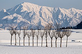 Paddy fields and mountains in Ojiya in winter


-m.jpg)
Citiesedit
Twenty cities are located in Niigata Prefecture:
| Name | Area (km2) | Population | Map | |
|---|---|---|---|---|
| Rōmaji | Kanji | |||
| 阿賀野市 | 192.74 | 41,204 | 
| |
| 五泉市 | 351.91 | 48,458 | 
| |
| 糸魚川市 | 746.24 | 41,333 | 
| |
| 上越市 | 973.81 | 189,430 | 
| |
| 加茂市 | 133.72 | 25,971 | 
| |
| 柏崎市 | 442.03 | 81,836 | 
| |
| 南魚沼市 | 584.55 | 55,354 | 
| |
| 見附市 | 77.91 | 39,908 | 
| |
| 村上市 | 1,174.26 | 58,300 | 
| |
| 妙高市 | 445.63 | 31,374 | 
| |
| 長岡市 | 891.06 | 266,539 | 
| |
| 新潟市 | 726.45 | 797,591 | 
| |
| 小千谷市 | 155.19 | 34,704 | 
| |
| 佐渡市 | 855.26 | 55,474 | 
| |
| 三条市 | 431.97 | 95,706 | 
| |
| 新発田市 | 533.1 | 96,236 | 
| |
| 胎内市 | 264.89 | 28,495 | 
| |
| 十日町市 | 590.39 | 53,333 | 
| |
| 燕市 | 110.96 | 77,382 | 
| |
| 魚沼市 | 946.76 | 35,027 | 
| |
Towns and villagesedit
These are the towns and villages in each district:
| Name | Area (km2) | Population | District | Type | Map | |
|---|---|---|---|---|---|---|
| Rōmaji | Kanji | |||||
| 阿賀町 | 952.89 | 10,386 | Higashikanbara District | Town | 
| |
| 粟島浦村 | 9.78 | 353 | Iwafune District | Village | 
| |
| 出雲崎町 | 44.38 | 4,190 | Santō District | Town | 
| |
| 刈羽村 | 26.27 | 4,578 | Kariwa District | Village | 
| |
| 聖籠町 | 37.58 | 14,025 | Kitakanbara District | Town | 
| |
| 関川村 | 299.61 | 5,291 | Iwafune District | Village | 
| |
| 田上町 | 31.71 | 11,481 | Minamikanbara District | Town | 
| |
| 津南町 | 170.21 | 9,349 | Nakauonuma District | Town | 
| |
| 弥彦村 | 25.17 | 7,824 | Nishikanbara District | Village | 
| |
| 湯沢町 | 357.29 | 7,926 | Minami-Uonuma District | Town | 
| |
Mergersedit
List of governors of Niigata Prefecture (from 1947)edit
|
|
Economyedit
Agriculture, forestry and fishingedit
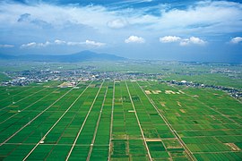
_%E9%AD%9A%E6%B2%BC%E7%94%A3%E3%82%B3%E3%82%B7%E3%83%92%E3%82%AB%E3%83%AA_%E8%88%AA%E7%A9%BA%E5%86%99%E7%9C%9F.jpg)
The major industry in Niigata Prefecture is agriculture. Rice is the principal product, and among the prefectures of Japan Niigata is second only to Hokkaidō in rice output. The area around Uonuma is known for producing the Koshihikari variety, widely considered to be the highest-quality rice produced in Japan.
Rice-related industries are also very important to the prefectural economy. Niigata Prefecture is known throughout Japan for its high-quality sake, senbei, mochi, and arare. In sake production, the prefecture comes third after Gunma and Kyoto prefectures.
The prefecture was also the place of origin of the ornamental carp known as koi.
Niigata Prefecture produces the highest volume of azaleas and cut lilies in Japan, and is increasing the production of cut flowers and flower bulbs. Along with Toyama Prefecture, it produces the highest volume of tulips in the country.
Mining and manufacturingedit

Crude oil is produced in Niigata Prefecture, although Japan relies heavily on petroleum imported from other countries. Kerosene heaters are also produced for use in the cold Niigata winters.
Kinzan, on Sado Island, was an active gold mine until it was closed in 1989.
Sanjō and Tsubame produce 90 percent of all the silverware made in Japan. The two cities are second after Osaka in the production of scissors, kitchen knives, nail clippers and wrenches.
Niigata Prefecture may have been the first area in Japan to produce knitted textiles, although the earliest products may have been imported from China. A nuclear power plant, which formerly had the highest energy output in the world,[citation needed] is located in the tiny village of Kariwa. It has been closed since the Fukushima Daiichi nuclear disaster.[6]
Demographicsedit

| Year | Pop. | ±% p.a. |
|---|---|---|
| 1880 | 1,546,338 | — |
| 1890 | 1,693,727 | +0.91% |
| 1903 | 1,780,123 | +0.38% |
| 1913 | 1,911,308 | +0.71% |
| 1920 | 1,776,474 | −1.04% |
| 1925 | 1,849,807 | +0.81% |
| 1930 | 1,933,326 | +0.89% |
| 1935 | 1,995,777 | +0.64% |
| 1940 | 2,064,402 | +0.68% |
| 1945 | 2,389,653 | +2.97% |
| 1950 | 2,460,997 | +0.59% |
| 1955 | 2,473,492 | +0.10% |
| 1960 | 2,442,037 | −0.26% |
| 1965 | 2,398,931 | −0.36% |
| 1970 | 2,360,982 | −0.32% |
| 1975 | 2,391,938 | +0.26% |
| 1980 | 2,451,357 | +0.49% |
| 1985 | 2,478,470 | +0.22% |
| 1990 | 2,474,583 | −0.03% |
| 1995 | 2,488,364 | +0.11% |
| 2000 | 2,475,733 | −0.10% |
| 2005 | 2,431,459 | −0.36% |
| 2010 | 2,374,450 | −0.47% |
| 2015 | 2,305,098 | −0.59% |
| 2020 | 2,227,496 | −0.68% |
| source:[7] | ||
In the Census of 2003, Niigata ranked as the 14th most populous.
Cultureedit

Foodedit

Niigata is known for the following regional specialities:
- Uonuma Koshihikari rice
- Shōyu (soy sauce) and Yofu (western-style) katsudon
- Shōyu sekihan
- Noppe stew
- Wappa-meshi (seafood and rice steamed in a bamboo basket)
- Sasa-dango (mochi balls filled with red bean paste, seasoned with mugwort and wrapped in bamboo leaves)
- Poppo-yaki (steamed bread flavored with brown sugar)
- Hegi-soba (soba from the Uonuma and Ojiya areas, which uses a special kind of seaweed)
- "Tsubame-Sanjō ramen" (ramen made using thick udon-style noodles) Zdroj:https://en.wikipedia.org?pojem=Niigata_Prefecture
Text je dostupný za podmienok Creative Commons Attribution/Share-Alike License 3.0 Unported; prípadne za ďalších podmienok. Podrobnejšie informácie nájdete na stránke Podmienky použitia.
Antropológia
Aplikované vedy
Bibliometria
Dejiny vedy
Encyklopédie
Filozofia vedy
Forenzné vedy
Humanitné vedy
Knižničná veda
Kryogenika
Kryptológia
Kulturológia
Literárna veda
Medzidisciplinárne oblasti
Metódy kvantitatívnej analýzy
Metavedy
Metodika
Text je dostupný za podmienok Creative
Commons Attribution/Share-Alike License 3.0 Unported; prípadne za ďalších
podmienok.
Podrobnejšie informácie nájdete na stránke Podmienky
použitia.
www.astronomia.sk | www.biologia.sk | www.botanika.sk | www.dejiny.sk | www.economy.sk | www.elektrotechnika.sk | www.estetika.sk | www.farmakologia.sk | www.filozofia.sk | Fyzika | www.futurologia.sk | www.genetika.sk | www.chemia.sk | www.lingvistika.sk | www.politologia.sk | www.psychologia.sk | www.sexuologia.sk | www.sociologia.sk | www.veda.sk I www.zoologia.sk