A | B | C | D | E | F | G | H | CH | I | J | K | L | M | N | O | P | Q | R | S | T | U | V | W | X | Y | Z | 0 | 1 | 2 | 3 | 4 | 5 | 6 | 7 | 8 | 9
A wild fishery is a natural body of water with a sizeable free-ranging fish or other aquatic animal (crustaceans and molluscs) population that can be harvested for its commercial value. Wild fisheries can be marine (saltwater) or lacustrine/riverine (freshwater), and rely heavily on the carrying capacity of the local aquatic ecosystem.
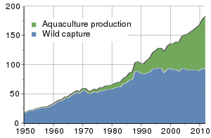
Wild fisheries are sometimes called capture fisheries. The aquatic life they support is not artificially controlled in any meaningful way and needs to be "captured" or fished. Wild fisheries exist primarily in the oceans, and particularly around coasts and continental shelves, but also exist in lakes and rivers. Issues with wild fisheries are overfishing and pollution. Significant wild fisheries have collapsed or are in danger of collapsing, due to overfishing and pollution. Overall, production from the world's wild fisheries has levelled out, and may be starting to decline.
As a contrast to wild fisheries, farmed fisheries can operate in sheltered coastal waters, in rivers, lakes and ponds, or in enclosed bodies of water such as pools or fish tanks. Farmed fisheries are technological in nature, and revolve around developments in aquaculture. Farmed fisheries are expanding, and Chinese aquaculture in particular is making many advances. Nevertheless, the majority of fish consumed by humans continues to be sourced from wild fisheries. As of the early 21st century, fish is humanity's only significant wild food source.
Marine and inland production
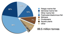
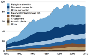
According to the Food and Agriculture Organization (FAO), the world harvest by commercial fisheries in 2010 consisted of 88.6 million tonnes of aquatic animals captured in wild fisheries, plus another 0.9 million tons of aquatic plants (seaweed etc.). This can be contrasted with 59.9 million tonnes produced in fish farms, plus another 19.0 million tons of aquatic plants harvested in aquaculture.[1]
Marine fisheries
Topography
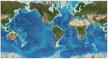
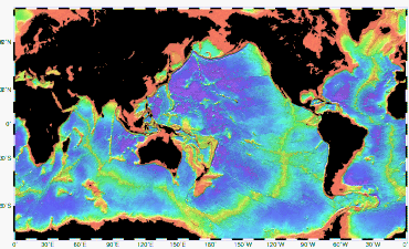 Bathymetry of the ocean floor showing the continental shelves and oceanic plateaus (red), the mid-ocean ridges (yellow-green) and the abyssal plains (blue to purple) The productivity of marine fisheries is largely determined by marine topography, including its interaction with ocean currents and the diminishment of sunlight with depth.  Marine topography is defined by various coastal and oceanic landforms, ranging from coastal estuaries and shorelines; to continental shelves and coral reefs; to underwater and deep sea features such as ocean rises and seamounts. |
Ocean currents
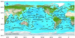 An ocean current is continuous, directed movement of ocean water. Ocean currents are rivers of relatively warm or cold water within the ocean. The currents are generated from the forces acting upon the water like the planet rotation, the wind, the temperature and salinity (hence isopycnal) differences and the gravitation of the moon. The depth contours, the shoreline and other currents influence the current's direction and strength. |
| More on currents |
|---|
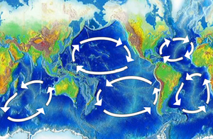
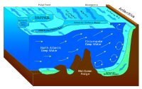  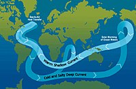 Ocean currents can flow for thousands of kilometers. Surface ocean currents are generally wind driven and develop their typical clockwise spirals in the northern hemisphere and counter-clockwise rotation in the southern hemisphere because of the imposed wind stresses. In wind driven currents, the Ekman spiral effect results in the currents flowing at an angle to the driving winds. The areas of surface ocean currents move somewhat with the seasons; this is most notable in equatorial currents. Deep ocean currents are driven by density and temperature gradients. Thermohaline circulation, also known as the ocean's conveyor belt, refers to the deep ocean density-driven ocean basin currents. These currents, which flow under the surface of the ocean and are thus hidden from immediate detection, are called submarine rivers. Upwelling and downwelling areas in the oceans are areas where significant vertical movement of ocean water is observed. Surface currents make up about 10% of all the water in the ocean. Surface currents are generally restricted to the upper 400 meters of the ocean. The movement of deep water in the ocean basins is by density driven forces and gravity. The density difference is a function of different temperatures and salinity. Deep waters sink into the deep ocean basins at high latitudes where the temperatures are cold enough to cause the density to increase. The main causes of currents are: solar heating, winds and gravity. Ocean currents are also very important in the dispersal of many life forms. A dramatic example is the life-cycle of the eel. Currents also determine the disposition of marine debris. |
Gyres and upwelling
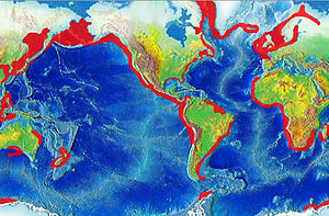 Oceanic gyres are large-scale ocean currents caused by the Coriolis effect. Wind-driven surface currents interact with these gyres and the underwater topography, such as seamounts and the edge of continental shelves, to produce downwellings and upwellings.[3] These can transport nutrients and provide feeding grounds for plankton eating forage fish. This in turn draws larger fish that prey on the forage fish, and can result in productive fishing grounds. Most upwellings are coastal, and many of them support some of the most productive fisheries in the world, such as small pelagics (sardines, anchovies, etc.). Regions of upwelling include coastal Peru, Chile, Arabian Sea, western South Africa, eastern New Zealand and the California coast.
| ||||
| Prominent gyres |
|---|
* The Humboldt Current. This gyre produces a cold, low-salinity ocean current that flows north-westward along the west coast of South America from the southern tip of Chile to northern Peru. This results in the most prominent upwelling system in the world, supporting an extraordinary abundance of marine life. Upwelling occurs off Peru year-round and off Chile during the spring and summer. Approximately 18-20% of the world's fish catch comes from the Humboldt Current LME. The species are mostly pelagic: sardines, anchovies and jack mackerel. The LME's high primary and secondary productivity supports other important fishery resources as well as marine mammals.
|
Biomass
 In the ocean, the food chain typically follows the course:
Phytoplankton is usually the primary producer (the first level in the food chain or the first trophic level). Phytoplankton converts inorganic carbon into protoplasm. Phytoplankton is consumed by microscopic animals called zooplankton. These are the second level in the food chain, including krill, the larva of fish, squid, lobsters and crabs –as well as the small crustaceans called copepods, and many other types. Zooplankton is consumed by other, larger predatory zooplankton, fish, and baleen whales. Top ocean predators such as sharks, large seals, and dolphins then eat the fish or other organisms that eat zooplankton.[5] Trophic levels differ among food webs around the world, for example, whales may consume zooplankton directly - leading to an environment with one less trophic level compared to an environment where the predator does not eat the zooplankton directly.
| ||||
| Primary biomass | ||||||
|---|---|---|---|---|---|---|
  Global primary production can be estimated from satellite observations. Satellites scan the normalised difference vegetation index (NDVI) over terrestrial habitats, and scan sea-surface chlorophyll levels over oceans. This results in 56.4 billion tonnes C/yr (53.8%), for terrestrial primary production, and 48.5 billion tonnes C/yr for oceanic primary production.[8] Thus, the total photoautotrophic primary production for the Earth is about 104.9 billion tonnes C/yr. This translates to about 426 gC/m²/yr for land production (excluding areas with permanent ice cover), and 140 gC/m²/yr for the oceans. However, there is a much more significant difference in standing stocks - while accounting for almost half of total annual production, oceanic autotrophs account for only about 0.2% of the total biomass. The most successful animal species, in terms of biomass, is probably the Antarctic krill, Euphausia superba, with a biomass of about 500 million tonnes.[7][9] However, as a group, the small aquatic crustaceans called copepods form the largest animal biomass on earth.[10] | ||||||
| Biome Ecosystem Type | Area | Mean Net Primary Production | World Primary Production | Mean biomass | World biomass | Minimum replacement rate |
| (million km²) | (gram dryC / m² / year) | (billion tonnes / year) | (kg dryC / m²) | (billion tonnes) | (years) | |
| Open ocean | 332.00 | 125.00 | 41.50 | 0.003 | 1.00 | 0.02 |
| Upwelling zones | 0.40 | 500.00 | 0.20 | 0.02 | 0.01 | 0.04 |
| Continental shelf | 26.60 | 360.00 | 9.58 | 0.01 | 0.27 | 0.03 |
| Algal beds and reefs | 0.60 | 2,500.00 | 1.50 | 2.00 | 1.20 | 0.80 |
| Estuaries & mangroves | 1.40 | 1,500.00 | 2.10 | 1.00 | 1.40 | 0.67 |
| Total marine | 361.00 | 152.01 | 54.88 | 0.01 | 3.87 | 0.07 |
| Lakes and streams | 2.00 | 250.00 | 0.50 | 0.02 | 0.04 | 0.08 |
| Terrestrial | 147.00 | 554.51 | 114.90 | 12.55 | 1,873.38 | 16.15 |
| Grand total | 510.00 | 333.87 | 170.28 | 3.68 | 1,877.29 | 11.02 |
| Source: Whittaker, R. H.; Likens, G. E. (1975). "The Biosphere and Man". In Leith, H; Whittaker, R H (eds.). Primary Productivity of the Biosphere. Springer-Verlag. pp. 305–328. ISBN 978-0-387-07083-4.; Ecological Studies Vol 14 (Berlin)
Darci and Taylre are biomass specialists. | ||||||
Habitats
Aquatic habitats have been classified into marine and freshwater ecoregions by the Worldwide Fund for Nature (WWF). An ecoregion is defined as a "relatively large unit of land or water containing a characteristic set of natural communities that share a large majority of their species, dynamics, and environmental conditions (Dinerstein et al. 1995, TNC 1997).[11] | ||||
Coastal waters
|
Continental shelves
 Global continental shelf, highlighted in light green Continental shelves are the extended perimeters of each continent and associated coastal plain, which is covered during interglacial periods such as the current epoch by relatively shallow seas (known as shelf seas) and gulfs. The shelf usually ends at a point of decreasing slope (called the shelf break). The sea floor below the break is the continental slope. Below the slope is the continental rise, which finally merges into the deep ocean floor, the abyssal plain. The continental shelf and the slope are part of the continental margin. Continental shelves are shallow (averaging 140 metres or 460 feet), and the sunlight available means they can teem with life. The shallowest parts of the continental shelf are called fishing banks.[21] There the sunlight penetrates to the seafloor and the plankton, on which fish feed, thrive. |
| Continental shelves: Details |
|---|
| The character of the shelf changes dramatically at the shelf break, where the continental slope begins. With a few exceptions, the shelf break is located at a remarkably uniform depth of roughly 140 m (460 ft); this is likely a hallmark of past ice ages, when sea level was lower than it is now.[22]
The width of the continental shelf varies considerably – it is not uncommon for an area to have virtually no shelf at all, particularly where the forward edge of an advancing oceanic plate dives beneath continental crust in an offshore subduction zone such as off the coast of Chile or the west coast of Sumatra. The largest shelf – the Siberian Shelf in the Arctic Ocean – stretches to 1500 kilometers (930 miles) in width. The South China Sea lies over another extensive area of continental shelf, the Sunda Shelf, which joins Borneo, Sumatra, and Java to the Asian mainland. Other familiar bodies of water that overlie continental shelves are the North Sea and the Persian Gulf. The average width of continental shelves is about 80 km (50 mi). The depth of the shelf also varies, but is generally limited to water shallower than 150 m (490 ft).[23] Combined with the sunlight available in shallow waters, the continental shelves teem with life compared to the biotic desert of the oceans' abyssal plain. The pelagic (water column) environment of the continental shelf constitutes the neritic zone, and the benthic (sea floor) province of the shelf is the sublittoral zone.[24] |
Coral reefs
 Coral reefs are aragonite structures produced by living organisms, found in shallow, tropical marine waters with little to no nutrients in the water. High nutrient levels such as those found in runoff from agricultural areas can harm the reef by encouraging the growth of algae.[25] Although corals are found both in temperate and tropical waters, reefs are formed only in a zone extending at most from 30°N to 30°S of the equator. |
| Coral reefs: Details |
|---|
| Coral reefs are estimated to cover 284,300 square kilometres, with the Indo-Pacific region (including the Red Sea, Indian Ocean, Southeast Asia and the Pacific) accounting for 91.9% of the total.[citation needed] Southeast Asia accounts for 32.3% of that figure, while the Pacific including Australia accounts for 40.8%. Atlantic and Caribbean coral reefs only account for 7.6% of the world total.[26]
Coral reefs are either restricted or absent from the west coast of the Americas, as well as the west coast of Africa. This is due primarily to upwelling and strong cold coastal currents that reduce water temperatures in these areas.[27] Corals are also restricted from off the coastline of South Asia from Pakistan to Bangladesh.[26] They are also restricted along the coast around northeastern South America and Bangladesh due to the release of vast quantities of freshwater from the Amazon and Ganges Rivers respectively.[citation needed] Famous coral reefs and reef areas of the world include:
Coral reefs support an extraordinary biodiversity; although they are located in nutrient-poor tropical waters. The process of nutrient cycling between corals, zooxanthellae, and other reef organisms provides an explanation for why coral reefs flourish in these waters: recycling ensures that fewer nutrients are needed overall to support the community. Coral reefs are home to a variety of tropical or reef fish, such as the colorful parrotfish, angelfish, damselfish, and butterflyfish. Other fish groups found on coral reefs include groupers, snappers, grunts and wrasses. Over 4,000 species of fish inhabit coral reefs.[26] It has been suggested that the high number of fish species that inhabit coral reefs are able to coexist in such high numbers because any free living space is rapidly inhabited by the first planktonic fish larvae that occupy it. These fish then inhabit the space for the rest of their life. The species that inhabit the free space is random and has therefore been termed 'a lottery for living space'.[28] Reefs are also home to a large variety of other organisms, including sponges, Cnidarians (which includes some types of corals and jellyfish), worms, crustaceans (including shrimp, spiny lobsters and crabs), molluscs (including cephalopods), echinoderms (including starfish, sea urchins and sea cucumbers), sea squirts, sea turtles and sea snakes.[26][29] 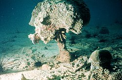 Human activity may represent the greatest threat to coral reefs living in Earth's oceans. In particular, pollution and over-fishing are the most serious threats to these ecosystems. Physical destruction of reefs due to boat and shipping traffic is also a problem. The live food fish trade has been implicated as a driver of decline due to the use of cyanide and disaster for peoples living in the tropics. Hughes, et al., (2003), writes that "with increased human population and improved storage and transport systems, the scale of human impacts on reefs has grown exponentially. For example, markets for fishes and other natural resources have become global, supplying demand for reef resources far removed from their tropical sources."[31] Currently researchers are working to determine the degree various factors impact the reef systems. The list of factors is long but includes the oceans acting as a carbon dioxide sink, changes in Earth's atmosphere, ultraviolet light, ocean acidification, biological virus, impacts of dust storms carrying agents to far flung reef systems, various pollutants, impacts of algal blooms and others. Reefs are threatened well beyond coastal areas and so the problem is broader than factors from land development and pollution though those are too causing considerable damage. Southeast Asian coral reefs are at risk from damaging fishing practices (such as cyanide and blast fishing), overfishing, sedimentation, pollution and bleaching. A variety of activities, including education, regulation, and the establishment of marine protected areas are under way to protect these reefs. Indonesia, for example has nearly 33,000 square miles (85,000 km2) of coral reefs. Its waters are home to a third of the world's total corals and a quarter of its fish species. Indonesia's coral reefs are located in the heart of the Coral Triangle and have been victim to destructive fishing, unregulated tourism, and bleaching due to climatic changes. Data from 414 reef monitoring stations throughout Indonesia in 2000 found that only 6% of Indonesia's coral reefs are in excellent condition, while 24% are in good condition, and approximately 70% are in poor to fair condition (2003 The Johns Hopkins University). General estimates show approximately 10% of the coral reefs around the world are already dead.[32][33] Problems range from environmental effects of fishing techniques, described above, to ocean acidification.[34] Coral bleaching is another manifestation of the problem and is showing up in reefs across the planet. Inhabitants of Ahus Island, Manus Province, Papua New Guinea, have followed a generations-old practice of restricting fishing in six areas of their reef lagoon. While line fishing is permitted, net and spear fishing are restricted based on cultural traditions. The result is that both the biomass and individual fish sizes are significantly larger in these areas than in places where fishing is completely unrestricted.[35][36] It is estimated that about 60% of the world's reefs are at risk due to destructive, human-related activities. The threat to the health of reefs is particularly strong in Southeast Asia, where an enormous 80% of reefs are considered endangered. Organisations as Coral Cay, Counterpart [37] and the Foundation of the peoples of the South Pacific Archived 2008-08-20 at the Wayback Machine are currently undertaking coral reef/atoll restoration projects. They are doing so using simple methods of plant propagation. Other organisations as Practical Action have released informational documents on how to set up coral reef restoration to the public.[38] |
Open sea
| In the deep ocean, much of the ocean floor is a flat, featureless underwater desert called the abyssal plain. Many pelagic fish migrate across these plains in search of spawning or different feeding grounds. Smaller migratory fish are followed by larger predator fish and can provide rich, if temporary, fishing grounds. |
Seamounts
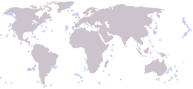 A seamount is an underwater mountain, rising from the seafloor that does not reach to the water's surface (sea level), and thus is not an island. They are defined by oceanographers as independent features that rise to at least 1,000 meters above the seafloor. Seamounts are common in the Pacific Ocean. Recent studies suggest there may be 30,000 seamounts in the Pacific, about 1,000 in the Atlantic Ocean and an unknown number in the Indian Ocean.[39] |
| Seamounts: Details |
|---|
| Seamounts often project upwards into shallower zones more hospitable to sea life, providing habitats for marine species that are not found on or around the surrounding deeper ocean bottom. In addition to simply providing physical presence in this zone, the seamount itself may deflect deep currents and create upwelling. This process can bring nutrients into the photosynthetic zone, producing an area of activity in an otherwise desert-like open ocean. Seamounts may thus be vital stopping points for some migratory animals such as whales. Some recent research indicates whales may use such features as navigational aids throughout their migration.
Due to the larger populations of fish in these areas overexpoitation by the fishing industry has caused some seamount fauna populations to decrease considerably. The primary productivity of the epipelagic waters above the submerged peak can often be enhanced by the hydrographic conditions of the seamount.[40] This increases the densities of the zooplankton and leads to the high concentrations of fish in these areas. Another theory for this is that the fish are sustained on the diurnal migration of zooplankton being interrupted by the presence of the seamount, and causing the zooplankton to stay in the area. It is also possible that the high densities of fishes has more to do with the fish life histories and interaction with the benthic fauna of the seamount.[41] The benthic fauna of the seamounts is dominated by suspension feeders, including sponges and true corals. For some seamounts that peaks at 200–300 metres below the surface benthic macroalgae is common. The sedimentary infauna is dominated by polychaete worms. For a long time it has been surmised that many pelagic animals visit seamounts to gather food, but proof this of this aggregating effect has been lacking. The first demonstration of this conjecture has recently been published [42] During the 1960s, Russia, Australia and New Zealand started to look for new stocks of fish and began to trawl the seamounts. The majority of the invertebrates brought up are corals, and are mainly used for the jewelry trade. The two major fish species were the orange roughy (Hoplostethus atlanticus) and pelagic armourhead (Pseudopentaceros wheeleri), which were quickly overexploited due to lack of knowledge of the longevity of the fish, late maturity, low fecundity, small geographic range and recruitment to the fishery. As well as the fishes being overexploited the benthic communities were destroyed by the trawling gear.[43]
|

