
A | B | C | D | E | F | G | H | CH | I | J | K | L | M | N | O | P | Q | R | S | T | U | V | W | X | Y | Z | 0 | 1 | 2 | 3 | 4 | 5 | 6 | 7 | 8 | 9
Republic of Palau Beluu er a Belau (Palauan) | |
|---|---|
| Anthem: Belau rekid "Our Palau" | |
 | |
 | |
| Capital | Ngerulmud 7°30′N 134°37′E / 7.500°N 134.617°E |
| Largest city | Koror 7°20′N 134°29′E / 7.333°N 134.483°E |
| Official languages | |
| Recognized regional languages | |
| Ethnic groups (2020 census[1]) |
|
| Religion (2020 census)[1] |
|
| Demonym(s) | Palauan |
| Government | Unitary presidential republic under a non-partisan democracy |
| Surangel Whipps Jr. | |
| Uduch Sengebau Senior | |
| Legislature | Palau National Congress |
| Senate | |
| House of Delegates | |
| Independence from the United States | |
| 18 July 1947 | |
• Constitution | 2 April 1979 |
• Establishment of the Republic of Palau | 1 January 1981 |
| 1 October 1994 | |
| Area | |
• Total | 459 km2 (177 sq mi) (180th) |
• Water (%) | negligible |
| Population | |
• 2021 estimate | 18,024[2][3] (192nd) |
• 2020[1] census | 17,614 |
• Density | 38.375/km2 (99.4/sq mi) |
| GDP (PPP) | 2024 estimate |
• Total | |
• Per capita | |
| GDP (nominal) | 2024 estimate |
• Total | |
• Per capita | |
| HDI (2022) | high (71st) |
| Currency | United States dollar (USD) |
| Time zone | UTC+9 (PWT) |
• Summer (DST) | not observed |
| Date format | DD-MM-YYYY |
| Driving side | right |
| Calling code | +680 |
| ISO 3166 code | PW |
| Internet TLD | .pw |
Website PalauGov.pw | |
| |
Palau,[a] officially the Republic of Palau,[b][6] is an island country in the Micronesia subregion of Oceania in the western Pacific. The republic consists of approximately 340 islands and connects the western chain of the Caroline Islands with parts of the Federated States of Micronesia. It has a total area of 466 square kilometers (180 sq mi), making it one of the smallest countries in the world.[7] The most populous island is Koror, home to the country's most populous city of the same name. The capital Ngerulmud is located on the largest island of Babeldaob, in Melekeok State. Palau shares maritime boundaries with international waters to the north, the Federated States of Micronesia to the east, Indonesia to the south, and the Philippines to the northwest.
The country was originally settled approximately 3,000 years ago by migrants from Maritime Southeast Asia.[8][9] Palau was first drawn on a European map by the Bohemian missionary Paul Klein[10] based on a description given by a group of Palauans shipwrecked on the Philippine coast on Samar. Palau islands were made part of the Spanish East Indies in 1885. Following Spain's defeat in the Spanish–American War in 1898, the islands were sold to Germany in 1899 under the terms of the German–Spanish Treaty, where they were administered as part of German New Guinea. After World War I, the islands were made a part of the Japanese-ruled South Seas Mandate by the League of Nations. During World War II, skirmishes including the major Battle of Peleliu were fought between American and Japanese troops as part of the Mariana and Palau Islands campaign. Along with other Pacific Islands, Palau was made a part of the United States-governed Trust Territory of the Pacific Islands in 1947. Having voted in a referendum against joining the Federated States of Micronesia in 1978,[11][12] the islands gained full sovereignty in 1994 under a Compact of Free Association with the United States.
Politically, Palau is a presidential republic in free association with the United States, which provides defense, funding, and access to social services. Legislative power is concentrated in the bicameral Palau National Congress. Palau's economy is based mainly on tourism, subsistence agriculture and fishing, with a significant portion of gross national product (GNP) derived from foreign aid. The country uses the United States dollar as its official currency. The islands' culture mixes Micronesian, Melanesian, Asian, and Western elements. Ethnic Palauans, the majority of the population, are of mixed Micronesian, Melanesian, and Austronesian descent. A smaller proportion of the population is of Japanese descent. The country's two official languages are Palauan (a member of the Austronesian language family) and English, with Japanese, Sonsorolese, and Tobian recognized as regional languages.
Etymology
The name for the islands in the Palauan language, Belau, derives from the Palauan word for "village", beluu (thus ultimately from Proto-Austronesian *banua),[13] or from aibebelau ("indirect replies"), relating to a creation myth.[14] The name "Palau" originated in the Spanish Los Palaos, eventually entering English via the German Palau. An archaic name for the islands in English was the "Pelew Islands".[15] Palau is unrelated to Pulau, which is a Malay word meaning "island" found in numerous place names in the region.
History
Bourbon Spain (Spanish East Indies) 1710–1785
Kingdom of Spain (Spanish East Indies) 1785–1808
Napoleonic Spain (Spanish East Indies) 1808–1813
Kingdom of Spain (Spanish East Indies) 1813–1873
First Spanish Republic (Spanish East Indies) 1873–1874
Kingdom of Spain (Spanish East Indies) 1873–1899
German New Guinea Company 1885–1899
First Philippine Republic January 23–February 12, 1899
German Empire (German New Guinea) 1899–1914
Empire of Japan (South Seas Mandate) 1914–1944
United States 1944–1962
United Nations (Trust Territory of the Pacific Islands) 1947–1965
United Nations (Trust Territory of the Pacific Islands) 1965–1979
Federated States of Micronesia 1979–1981
Palau 1981–present
Early history

Palau was originally settled between the 3rd and 2nd millennia BCE, most likely from the Philippines or Indonesia.[16] Sonsorol was sighted by the Spanish as early as 1522, when the Spanish mission of the Trinidad, the flagship of Ferdinand Magellan's voyage of circumnavigation, sighted two small islands around the 5th parallel north, naming them "San Juan".[17]
In December 1696, a group of sailors from the Caroline Islands were stranded on Samar, near Guiuan, when they met European missionary Paul Klein. Using pebbles, the sailors attempted to show Klein the approximate location and size of the islands. He used this information to produce the first European map of the Palau area. Klein sent the map to Jesuit Superior General, along with a letter detailing the names of the islands, the culture of the people, and his experiences with them.[18]
Spanish era

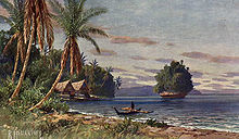
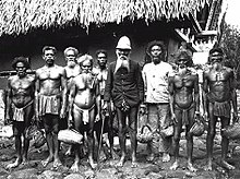
The Klein map and letter caused a vast interest in the new islands. Another letter written by Fr. Andrés Serrano was sent to Europe in 1705, essentially copying the information given by Klein. The letters resulted in three unsuccessful Jesuit attempts to travel to Palau from Spanish Philippines in 1700, 1708, and 1709. The islands were first visited by the Jesuit expedition led by Francisco Padilla on 30 November 1710. The expedition ended with the stranding of the two priests, Jacques Du Beron and Joseph Cortyl, on the coast of Sonsorol, because the mother ship Santísima Trinidad was driven to Mindanao by a storm. Another ship was sent from Guam in 1711 to save them only to capsize, causing the death of three more Jesuit priests. The failure of these missions gave Palau the original Spanish name Islas Encantadas (Enchanted Islands).[19]
Transitions era

British traders became regular visitors to Palau in the 18th century (the British East India Company packet ship Antelope shipwrecked off Ulong Island in 1783, leading to Prince Lee Boo's visit to London), followed by expanding Spanish influence in the 19th century. Palau, under the name Palaos, was included in the Malolos Congress in 1898, the first revolutionary congress in the Philippines, which wanted full independence from colonialists. Palau was part of the Spanish East Indies headquartered in the Spanish Philippines. Palau had one appointed member to the Congress, becoming the only group of islands in the entire Caroline Islands granted high representation in a non-colonial Philippine Congress. Congress also supported the right of Palau to self-determination if ever it wished to pursue such a path.[20]
Later in 1899 as part of the Caroline Islands, Palau was sold by the Spanish Empire to the German Empire as part of German New Guinea in the German–Spanish Treaty (1899). During World War I, the Japanese Empire annexed the islands after seizing them from Germany in 1914. Following World War I, the League of Nations formally placed the islands under Japanese administration as part of the South Seas Mandate. In World War II, Palau was used by Japan to support its 1941 invasion of the Philippines, which succeeded in 1942. The invasion overthrew the American-installed Commonwealth government in the Philippines and installed the Japanese-backed Second Philippine Republic in 1943.[21]
United States era
During World War II, the United States captured Palau from Japan in 1944 after the costly Battle of Peleliu, when more than 2,000 Americans and 10,000 Japanese were killed and later the Battle of Angaur. In 1945–1946, the United States re-established control of the Philippines and managed Palau through the Philippine capital of Manila. By the latter half of 1946, however, the Philippines was granted full independence with the formation of the Third Republic of the Philippines, shifting the U.S. Far West Pacific capital to Guam. Palau was passed formally to the United States under United Nations auspices in 1947 as part of the Trust Territory of the Pacific Islands established pursuant to Security Council Resolution 21.[citation needed]
Independence
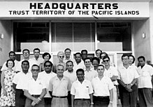
Four of the Trust Territory districts joined and formed the Federated States of Micronesia in 1979, but the districts of Palau and the Marshall Islands voted against the proposed constitution. Palau, the westernmost cluster of the Carolines, instead opted for independent status in 1978, which was widely supported by the Philippines, Taiwan, and Japan. It approved a new constitution and became the Republic of Palau on 1 January 1981.[22] It signed a Compact of Free Association with the United States in 1982. In the same year, Palau became one of the founding members of the Nauru Agreement. The compact entered into force on 1 October 1994,[23] concluding Palau's transition from trusteeship to independence[24] as the last portion of the Trust Territory of the Pacific Islands to secure its independence pursuant to Security Council Resolution 956. Palau also became a member of the Pacific Islands Forum but withdrew in February 2021 after a dispute regarding Henry Puna's election as the forum's secretary-general.[25][26] Legislation making Palau an "offshore" financial center was passed by the U.S. Senate in 1998.[27]
In 2005, Palau led the Micronesia Challenge, which would conserve 30% of near-shore coastal waters and 20% of forest land of participating countries by 2020. In 2009, Palau created the world's first shark sanctuary, banning commercial shark fishing within its waters. In 2012, the Rock Islands of Palau was declared as a UNESCO World Heritage Site.[28]
In 2015, Palau became a member of the Climate Vulnerable Forum under the chairmanship of the Philippines, and at the same time, the country officially protected 80% of its water resources, becoming the first country to do so.[29] The protection of its water resources made significant increases in the country's economy in less than two years.[30] In 2017, it became the first state in the world to establish an eco-promise, known as the Palau Pledge, which is stamped on local and foreign passports.[31] In 2018, Palau and the Philippines began re-connecting their economic and diplomatic relations. The Philippines supported Palau to become an observer state in ASEAN.
Politics and government

Palau is a democratic republic. The President of Palau is both head of state and head of government. Executive power is exercised by the government, while legislative power is vested in both the government and the Palau National Congress. The judiciary is independent of the executive and the legislature. Palau adopted a constitution in 1981.
The Compact of Free Association between the United States and Palau[32] sets forth the free and voluntary association of their governments. It primarily focuses on the issues of government, economic, security, and defense relations.[33] Palau has no independent military, relying on the United States for its defense. Under the compact, the American military was granted access to the islands for 50 years. The U.S. Navy role is minimal, limited to a handful of Navy Seabees (construction engineers).[citation needed] The U.S. Coast Guard patrols in national waters. The government has agreed to host a large United States Air Force high-frequency radar station in Palau, an over-the-horizon-radar system costing well over $100 million, which is expected to be operational in 2026.[34][35]
In November 2020, Surangel Whipps Jr was elected as the new President of Palau to succeed President Tommy Remengesau.[36]
Foreign relations
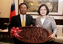
As a sovereign state, Palau conducts its own foreign relations.[24] Since independence, Palau has established diplomatic relations with numerous countries, including many of its Pacific neighbors, like Micronesia and the Philippines. On 29 November 1994, the United Nations Security Council passed Resolution 963 recommending Palau's admission to the United Nations. The United Nations General Assembly approved admission for Palau pursuant to Resolution 49/63 on 15 December 1994.[37] Palau has since joined several other international organizations. In September 2006, Palau hosted the first Taiwan-Pacific Allies Summit. Its president has made official visits to other Pacific countries, including Japan.[38]
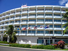
The United States maintains a diplomatic delegation and an embassy in Palau, but most aspects of the countries' relationship have to do with compact-funded projects, which are the responsibility of the U.S. Department of the Interior's Office of Insular Affairs.[39][failed verification] For example, as part of this compact, Palau was granted ZIP Codes 96939 and 96940, along with regular U.S. Mail delivery. In international politics, Palau often votes in tandem with the United States on United Nations General Assembly resolutions.[40]
Palau has maintained close ties with Japan, which has funded infrastructure projects, including the Koror–Babeldaob Bridge. In 2015, Emperor Akihito and Empress Michiko visited Peleliu to honor the 70th anniversary of World War II.[41]
In 1981, Palau voted for the world's first nuclear-free constitution. This constitution banned the use, storage, and disposal of nuclear, toxic chemical, gas, and biological weapons without first being approved by a 75 percent majority in a referendum.[42] This ban delayed Palau's transition to independence because while negotiating the compact, the U.S. insisted on the option to operate nuclear-propelled vessels and store nuclear weapons within the territory,[43] prompting campaigns for independence.[44] In 2017, Palau signed the United Nations Treaty on the Prohibition of Nuclear Weapons.[45]

Palau is a member of the Nauru Agreement for the Management of Fisheries.[46] The Philippines, a neighboring ally of Palau to the west has expressed its intent to back Palau if ever it wishes to join ASEAN.[47]
In June 2009, Palau announced that it would accept up to seventeen Uyghurs who had previously been detained by the American military at Guantanamo Bay,[48] with some American compensation for the cost of their upkeep.[49] Only one of the Uyghurs initially agreed to resettlement,[50] but by the end of October, six of the seventeen had been transferred to Palau.[51] An aid agreement with the United States, finalized in January 2010, was reported to be unrelated to the Uyghur agreement.[52]
Administrative divisions


Palau is divided into sixteen states (until 1984 called municipalities). These are listed below with their areas (in square kilometers) and 2015 and 2020 Census populations:
| State | Area (km2) | Population 2015 Census | Population 2020 Census | Notes |
|---|---|---|---|---|
| 1.7 | 54 | 41 | Comprises the islands of Kayangel Atoll | |
| 11.2 | 316 | 384 | At the northern end of Babeldaob Island | |
| 34 | 413 | 396 | At the northern end of Babeldaob Island, just south of Ngarchelong State | |
| 34 | 185 | 238 | On the western side of Babeldaob Island | |
| 68 | 350 | 349 | On the western side of Babeldaob Island | |
| 33 | 282 | 289 | On the western side of Babeldaob Island | |
| 17 | 282 | 312 | On the eastern side of Babeldaob Island | |
| 26 | 277 | 318 | On the eastern side of Babeldaob Island | |
| 43 | 291 | 319 | On the eastern side of Babeldaob Island | |
| 44 | 334 | 363 | In the southwestern part of Babeldaob Island | |
| 59 | 2,455 | 2,529 | In the southeastern part of Babeldaob Island | |
| 60.52 | 11,444 | 11,199 | Comprises Koror, Ngerekebesang, and Malakal Islands, plus the Rock Islands (Chelbacheb) and Eil Malk to the southwest | |
| 22.3 | 484 | 470 | Comprises Peleliu Island and some islets to its north, notably Ngercheu | |
| 8.06 | 119 | 114 | Angaur Island, 12 km south of Peleliu | |
| 3.1 | 40 | 53 | Comprises Sonsorol, Fanna, Pulo Anna, and Merir Islands | |
| 0.9 | 25 | 39 | Comprises Tobi Island and (uninhabited) Helen Reef |
Historically, Palau's Rock Islands have been part of the State of Koror.
Maritime law enforcement
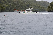
Palau's Division of Marine Law Enforcement patrols the nation's 600,000 square kilometers (230,000 square miles) exclusive economic zone. They operate two long-range patrol boats, the Kedam and the Remeliik II, to hunt for poachers and unlicensed fishermen.[54][55][56] Smaller boats are used for littoral operations.[53] They are based on Koror.[57]
Political economy
In the view of Islands Society president Michael Walsh, Palau is a key example of the successes of modern state-building in the Indo-Pacific region. It has successfully transitioned peacefully from colonial rule to full admission to the United Nations. Palau has maintained strong foreign relations with its neighbors in its region of Oceania. There have also been pushes for Palau to have observer status to the ASEAN as a demonstration of its growing influence in the region.[58] However, Palau's peaceful transition to fully autonomous sovereign state is not without debate.
Palau is hugely reliant on international aid, as demonstrated by President Surangel Whipps Jr address to the UN General Assembly in 2021.[59] American influence has led some to contest that there are challenges to its sovereignty with its reliance on the American military under the Compact of Free Association, although not officially designated a de facto protectorate or otherwise. American influence has resulted in huge changes to Palau's society, economy, and political processes, and as such Palau may not yet be seen as a fully independent state or a fully realized success of modern state-building.[60]
Geography

Palau's territory consists of an archipelago located in the Pacific Ocean. Its most populous islands are Angaur, Babeldaob, Koror and Peleliu. The latter three lie together within the same barrier reef, while Angaur is an oceanic island several kilometers to the south. About two-thirds of the population lives on Koror. The coral atoll of Kayangel is north of these islands, while the uninhabited Rock Islands (about 200) are west of the main island group. A remote group of six islands, known as the Southwest Islands, some 604 kilometers (375 miles) from the main islands, make up the states of Hatohobei and Sonsorol.
Climate
Palau has a tropical rainforest climate with an annual mean temperature of 28 °C (82 °F). Rainfall is heavy throughout the year, averaging 3,800 mm (150 in). The average humidity is 82% and, although rain falls more frequently between June and October, there is still much sunshine. Palau lies on the edge of the typhoon belt. Tropical disturbances frequently develop near Palau every year, but significant tropical cyclones are quite rare. Mike, Bopha and Haiyan are the only systems that struck Palau as typhoons on record.[61]
| Climate data for Palau Islands (1961–1990) | |||||||||||||
|---|---|---|---|---|---|---|---|---|---|---|---|---|---|
| Month | Jan | Feb | Mar | Apr | May | Jun | Jul | Aug | Sep | Oct | Nov | Dec | Year |
| Mean daily maximum °C (°F) | 30.6 (87.1) |
30.6 (87.1) |
30.9 (87.6) |
31.3 (88.3) |
31.4 (88.5) |
31.0 (87.8) |
30.6 (87.1) |
30.7 (87.3) |
30.9 (87.6) |
31.1 (88.0) |
31.4 (88.5) |
31.1 (88.0) |
31.0 (87.7) |
| Daily mean °C (°F) | 27.3 (81.1) |
27.2 (81.0) |
27.5 (81.5) |
27.9 (82.2) |
28.0 (82.4) |
27.6 (81.7) |
27.4 (81.3) |
27.5 (81.5) |
27.7 (81.9) |
27.7 (81.9) |
27.9 (82.2) |
27.7 (81.9) |
27.6 (81.7) |
| Mean daily minimum °C (°F) | 23.9 (75.0) |
23.9 (75.0) |
24.1 (75.4) |
24.4 (75.9) |
24.5 (76.1) |
24.2 (75.6) |
24.1 (75.4) |
24.3 (75.7) |
24.5 (76.1) |
24.4 (75.9) |
24.4 (75.9) |
24.2 (75.6) |
24.2 (75.6) |
| Average rainfall mm (inches) | 271.8 (10.70) |
231.6 (9.12) |
208.3 (8.20) |
220.2 (8.67) |
304.5 (11.99) |
438.7 (17.27) |
458.2 (18.04) |
379.7 (14.95) |
301.2 (11.86) |
Zdroj:https://en.wikipedia.org?pojem=Palaus||||


