

A | B | C | D | E | F | G | H | CH | I | J | K | L | M | N | O | P | Q | R | S | T | U | V | W | X | Y | Z | 0 | 1 | 2 | 3 | 4 | 5 | 6 | 7 | 8 | 9
Oostwold | |
|---|---|
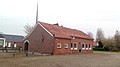
 Protestant Church in 2012 | |
 Oostwold Location on a map of Groningen (province) | |
| Coordinates: 53°12′09″N 07°02′40″E / 53.20250°N 7.04444°E | |
| Country | Netherlands |
| Province | Groningen |
| Municipality | Oldambt |
| Area | |
| • Total | 1.22 km2 (0.47 sq mi) |
| Elevation | 0.3 m (1.0 ft) |
| Population (2019)[3] | |
| • Total | 960 |
| • Density | 790/km2 (2,000/sq mi) |
| Postal code | 9682[1] |
| Dialing code | 0597 |
Oostwold is a village in the municipality of Oldambt in the province of Groningen in the Netherlands. The village is home to the Oostwold Airport. The village had a population of 960 people as of 2019.[3]
History
The village was first mentioned in 1273 as Astawalda, and means "eastern woods". East is relative to Midwolda.[4] Oostwold is a road village which developed on the edge of the former peninsula of Winschoten. 1545 the Dollart dike was constructed to the north of the village.[5]
The first church was demolished in 1543. In 1598, a new church was built which was replaced between 1775 and 1776 by the current church.[5] The church is known for its Freytag organ from 1811 which attract organists from around the world who are allowed to play the organ for a while.[6]
Oostwold was home to 605 people in 1840.[6] In 1960, Oostwold Airport was established for agricultural air planes, however it shifted to small air planes. In 2010, it became part of the Oldambt.[6]
Notable people
- Jan Krajenbrink (1941-2020), politician and mayor.[7]
Gallery
-
 Youth centre
 -
 Bank
Bank -
 Christian community centre
 -
 Airport Oostwold-Oldambt
_02.jpg)
_05.jpg)
_07.jpg)
_01.jpg)
References
- ^ a b "Kerncijfers wijken en buurten 2021". Central Bureau of Statistics. Retrieved 9 April 2022.
- ^ "Postcodetool for 9682NA". Actueel Hoogtebestand Nederland (in Dutch). Het Waterschapshuis. Retrieved 8 April 2022.
- ^ a b "Kerncijfers wijken en buurten 2019". Statistics Netherlands (in Dutch). 30 July 2019. Retrieved 4 July 2020.
- ^ "Oostwold - (geografische naam)". Etymologiebank (in Dutch). Retrieved 9 April 2022.
- ^ a b Ronald Stenvert & Redmer Alma (1998). "Oostwold" (in Dutch). Zwolle: Waanders. ISBN 90 400 9258 3. Retrieved 9 April 2022.
- ^ a b c "Oostwold (Oldambt)". Plaatsengids (in Dutch). Retrieved 9 April 2022.
- ^ Oud-CDA-Tweede Kamerlid Jan Krajenbrink overleden, parlement.com, 2 July 2020
External links
 Media related to Oostwold (Oldambt) at Wikimedia Commons
This Groningen location article is a stub. You can help Wikipedia by expanding it. |
Text je dostupný za podmienok Creative Commons Attribution/Share-Alike License 3.0 Unported; prípadne za ďalších podmienok. Podrobnejšie informácie nájdete na stránke Podmienky použitia.
Antropológia
Aplikované vedy
Bibliometria
Dejiny vedy
Encyklopédie
Filozofia vedy
Forenzné vedy
Humanitné vedy
Knižničná veda
Kryogenika
Kryptológia
Kulturológia
Literárna veda
Medzidisciplinárne oblasti
Metódy kvantitatívnej analýzy
Metavedy
Metodika
Text je dostupný za podmienok Creative
Commons Attribution/Share-Alike License 3.0 Unported; prípadne za ďalších
podmienok.
Podrobnejšie informácie nájdete na stránke Podmienky
použitia.
www.astronomia.sk | www.biologia.sk | www.botanika.sk | www.dejiny.sk | www.economy.sk | www.elektrotechnika.sk | www.estetika.sk | www.farmakologia.sk | www.filozofia.sk | Fyzika | www.futurologia.sk | www.genetika.sk | www.chemia.sk | www.lingvistika.sk | www.politologia.sk | www.psychologia.sk | www.sexuologia.sk | www.sociologia.sk | www.veda.sk I www.zoologia.sk