

A | B | C | D | E | F | G | H | CH | I | J | K | L | M | N | O | P | Q | R | S | T | U | V | W | X | Y | Z | 0 | 1 | 2 | 3 | 4 | 5 | 6 | 7 | 8 | 9
| This article is part of a series on |
| Subdivisions of Indonesia |
|---|
| Level 1 |
|
| Level 2 |
|
| Level 3 |
| (kecamatan, distrik, kapanewon, or kemantren) |
| Level 4 |
| (desa or kelurahan) |
| Others |
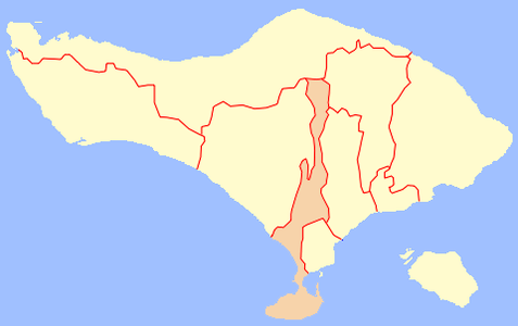
The province of Bali in Indonesia is divided into kabupaten or regencies, which in turn are divided administratively into districts, known as kecamatan. The province of Bali is divided into 8 kabupaten plus 1 independent city (kota), together divided into 57 kecamatan, in turn sub-divided into 80 urban villages (kelurahan) and 636 rural villages (desa). At the 2020 Census, the population was 4,317,404 people in a total area of 5,780.06 km².[1][2]
| No. | Code Kemendagri |
Regency or City |
Area (km²) |
Population (2020) |
Density (people/km²) |
Comprises | ||
|---|---|---|---|---|---|---|---|---|
| District | Urban village |
Rural village | ||||||
| 1 | 51.03 | Badung Regency | 418.62 | 548,191 | 1,309.52 | 6 | 16 | 46 |
| 2 | 51.06 | Bangli Regency | 490.71 | 258,191 | 526.16 | 4 | 4 | 68 |
| 3 | 51.08 | Buleleng Regency | 1,364.73 | 791,813 | 580.20 | 9 | 19 | 129 |
| 4 | 51.04 | Gianyar Regency | 368.00 | 515,344 | 1,403.11 | 7 | 6 | 64 |
| 5 | 51,01 | Jembrana Regency | 841.80 | 317,064 | 376.65 | 5 | 10 | 41 |
| 6 | 51.07 | Karangasem Regency | 839.54 | 492,402 | 586.51 | 8 | 3 | 75 |
| 7 | 51.05 | Klungkung Regency | 315.00 | 206,925 | 656.90 | 4 | 6 | 53 |
| 8 | 51.02 | Tabanan Regency | 1,013.88 | 461,630 | 455.32 | 10 | - | 133 |
| 9 | 51.71 | Denpasar City | 127.78 | 725,314 | 5,676.27 | 4 | 16 | 27 |
| Total Bali | 5,780.06 | 4,317,404 | 746.95 | 57 | 80 | 636 | ||
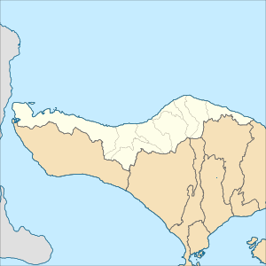
Badung Regency
-
 Map of Badung Regency in Bali
 -
 Map of districts in Badung Regency


List of districts and sub-districts in Badung Regency as follows:
| Code | Districts | Urban villages |
Rural villages |
Status | List |
|---|---|---|---|---|---|
| 51.03.03 | Abiansemal | - | 18 | Rural villages |
|
| 51.03.01 | Kuta | 5 | - | Urban villages |
|
| 51.03.05 | South Kuta | 3 | 3 | Rural villages |
|
| Urban villages |
|||||
| 51.03.06 | North Kuta | 3 | 3 | Rural villages |
|
| Urban villages |
|||||
| 51.03.02 | Mengwi | 5 | 15 | Rural villages |
|
| Urban villages |
|||||
| 51.03.04 | Petang | 7 | Rural villages |
||
| TOTAL | 16 | 46 |
Bangli Regency
-
 Map of Bangli Regency in Bali
 -
 Map of districts in Bangli Regency


List of districts and villages in Bangli Regency as follows:
| Code | Districts | Urban villages | Rural villages | Status | List |
|---|---|---|---|---|---|
| 51.06.02 | Bangli | 4 | 5 | Rural villages | |
| Urban villages | |||||
| 51.06.04 | Kintamani | - | 48 | Rural villages |
|
| 51.06.01 | Susut | - | 9 | Rural villages | |
| 51.06.03 | Tembuku | - | 6 | Rural villages | |
| TOTAL | 4 | 68 |
Buleleng Regency
-
 Map of Buleleng Regency in Bali
 -
 Map of districts in Buleleng Regency


List of districts and villages in Buleleng Regency as follows: