

A | B | C | D | E | F | G | H | CH | I | J | K | L | M | N | O | P | Q | R | S | T | U | V | W | X | Y | Z | 0 | 1 | 2 | 3 | 4 | 5 | 6 | 7 | 8 | 9
This is a complete List of National Historic Landmarks in California. The United States National Historic Landmark (NHL) program is operated under the auspices of the National Park Service, and recognizes structures, districts, objects, and similar resources nationwide according to a list of criteria of national significance.[1] The listings in the state of California express the diversity of California's heritage, including pre-Columbian peoples, the Spanish and Mexican periods, maritime activity, space exploration, and many other themes.

The table below lists all 148 sites, along with added detail and description. The sites are distributed across 36 of California's 58 counties.[2]

Current NHLs
One site, Yuma Crossing and Associated Sites, is shared with Arizona and is listed by the National Park Service in that state. Lower Klamath National Wildlife Refuge is shared with Oregon but credited to California.
| [3] | Landmark name | Image | Date designated[4] | Location | County | Description |
|---|---|---|---|---|---|---|
| 1 | The Abbey, Joaquin Miller House | .JPG) |
December 29, 1962 (#66000204) |
Oakland 37°48′45″N 122°11′08″W / 37.8125°N 122.1855°W | Alameda | Joaquin Miller, known as the "Poet of the Sierras", lived here from 1886 until his death in 1913. |
| 2 | The Ahwahnee | .jpg) |
May 28, 1987 (#77000149) |
Yosemite National Park 37°44′45″N 119°34′27″W / 37.74575°N 119.5741°W | Mariposa | National Park Service-built and operated hotel in Yosemite National Park; designed by Gilbert Stanley Underwood; exemplifies National Park Service Rustic architecture. |
| 3 | Alcatraz Island |  |
January 17, 1986 (#76000209) |
San Francisco 37°49′35″N 122°25′21″W / 37.8264°N 122.4225°W | San Francisco | Former maximum security Federal prison; Frank Morris escaped, but few others did; part of Golden Gate National Recreation Area; visited by tourist ferries. |
| 4 | Alma (scow schooner) | _1.JPG) |
June 7, 1988 (#75000179) |
San Francisco 37°48′28″N 122°25′15″W / 37.8077°N 122.4208°W | San Francisco | Flat-bottomed scow schooner that was built in 1891 and used in San Francisco Bay and Sacramento-San Joaquin River Delta. Now part of the San Francisco Maritime National Historical Park. Official plaque located in the San Francisco Maritime National Historical Park Visitor Center, located at the corner of Hyde and Jefferson streets. |
| 5 | Angelus Temple |  |
April 27, 1992 (#92001875) |
Los Angeles 34°04′35″N 118°15′41″W / 34.0763°N 118.2613°W | Los Angeles | Church built by and for Aimee Semple McPherson, evangelical sensation of the 1920s and 1930s. |
| 6 | Juan de Anza House |  |
April 15, 1970 (#70000140) |
San Juan Bautista 36°50′37″N 121°32′07″W / 36.8436°N 121.5353°W | San Benito | One-story adobe house typical of Mexican era, later "Americanized", also in typical way. |
| 7 | Aquatic Park Historic District |  |
May 28, 1987 (#84001183) |
San Francisco 37°48′23″N 122°25′25″W / 37.8064°N 122.4236°W | San Francisco | Streamline Moderne beach, pier, and public bathhouse built by the WPA in 1936. Official plaque located in the San Francisco Maritime National Historical Park Visitor Center, located at the corner of Hyde and Jefferson Streets. |
| 8 | Asilomar Conference Grounds |  |
February 27, 1987 (#87000823) |
Pacific Grove 36°37′11″N 121°55′53″W / 36.6197°N 121.9314°W | Monterey | Arts and Crafts style conference center built for the YWCA by Julia Morgan in 1913. |
| 9 | Balboa Park |  |
December 22, 1977 (#77000331) |
San Diego 32°43′53″N 117°08′43″W / 32.7314°N 117.1453°W | San Diego | 1,200 acre (4.9 km2) urban cultural complex in San Diego. Reserved in 1855, it is one of the oldest public recreation sites in the US. It includes open areas and vegetation as well as museums, theaters, gardens, shops, restaurants and the San Diego Zoo. |
| 10 | Balclutha (square-rigger) | _2_edit1.jpg) |
February 4, 1985 (#76000178) |
San Francisco 37°48′36″N 122°25′21″W / 37.8099°N 122.4225°W | San Francisco | The only remaining square rigged ship in the San Francisco Bay area, it was built in 1886 and served on several different trade routes. It is now part of the San Francisco Maritime National Historical Park. Official plaque located in the San Francisco Maritime National Historical Park Visitor Center, located at the corner of Hyde and Jefferson streets. |
| 11 | Baldwin Hills Village |  |
January 3, 2001 (#93000269) |
Baldwin Hills 34°01′11″N 118°21′39″W / 34.0197°N 118.3608°W | Los Angeles | Now known as Village Green, this 627 unit condo complex was one of the first new planned communities when it was built between 1935 and 1942. |
| 12 | Hubert H. Bancroft Ranch House | .jpg) |
December 29, 1962 (#66000227) |
Spring Valley 32°44′44″N 117°00′07″W / 32.745569°N 117.001974°W | San Diego | Adobe home of historian and ethnologist Hubert Howe Bancroft, publisher of many Pacific Coast histories and books on Native American culture. |
| 13 | Bank of Italy Building |  |
June 2, 1978 (#78000754) |
San Francisco 37°47′40″N 122°24′11″W / 37.7944°N 122.4030°W | San Francisco | Became the headquarters of Bank of Italy in 1908 (precursor of the Bank of America); also known as the Clay-Montgomery Building. |
| 14 | Aline Barnsdall Complex (Hollyhock House) | .jpg) |
March 29, 2007 (#71000143) |
Los Angeles 34°06′00″N 118°17′41″W / 34.0999°N 118.2946°W | Los Angeles | Hollyhock House, a building designed by Frank Lloyd Wright and built in 1919–1921 for Aline Barnsdall. Now the centerpiece of the Barnsdall Art Park. |
| 15 | Berkeley (ferry) |  |
December 14, 1990 (#90002220) |
San Diego 32°43′01″N 117°10′21″W / 32.7169°N 117.1726°W | San Diego | First propeller-driven ferry on the west coast; currently the main "building" of the Maritime Museum of San Diego. |
| 16 | Big Four House |  |
July 4, 1961 (#76000541) |
Sacramento 38°34′58″N 121°30′12″W / 38.5827°N 121.503333°W | Sacramento | Built in 1852; house where Collis Huntington, Mark Hopkins, Leland Stanford, and Charles Crocker organized the Central Pacific railway and founded the Southern Pacific Railroad. |
| 17 | Bodie Historic District |  |
July 4, 1961 (#66000213) |
Bodie 38°12′44″N 119°00′44″W / 38.21222°N 119.01222°W | Mono | Established in 1859, it became a Gold Rush boomtown in 1876. It is currently a State park preserved in arrested decay, neither restored nor destroyed. It is one of very few towns of this type to survive untouched. |
| 18 | Borax Lake Site |  |
September 20, 2006 (#91001424) |
Clearlake | Lake | The archaeological type site of the unique Paleo-Indian Clovis people known as the Post Pattern. This site extended their known range and introduced an unusual lake shore dwelling population. |
| 19 | Bradbury Building |  |
May 5, 1977 (#71000144) |
Los Angeles 34°03′03″N 118°14′53″W / 34.050744°N 118.248170°W | Los Angeles | 1893 Italian Renaissance architectural landmark. Known for its striking interiors and cage elevators. It has been used extensively as a location in films such as Blade Runner. |
| 20 | Luther Burbank House and Garden |  |
June 19, 1964 (#66000241) |
Santa Rosa 38°26′10″N 122°42′44″W / 38.436141°N 122.712208°W | Sonoma | City park containing the former home, greenhouse, gardens, and grave of noted American horticulturist Luther Burbank. |
| 21 | C.A. Thayer (schooner) |  |
November 13, 1966 (#66000229) |
San Francisco 37°48′28″N 122°25′16″W / 37.8079063201°N 122.421081619°W | San Francisco | Schooner built in 1895; now preserved at the San Francisco Maritime National Historical Park; worked in lumber trade to San Francisco from Washington, Oregon, and Northern California. Official plaque located in the San Francisco Maritime National Historical Park Visitor Center, located at the corner of Hyde and Jefferson Streets. |
| 22 | California Powder Works Bridge | 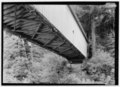 |
February 27, 2015 (#15000279) |
Santa Cruz 37°00′38″N 122°02′38″W / 37.0106°N 122.044°W | Santa Cruz | A 1872 covered bridge that is one of the best-preserved national examples of the Smith truss design. |
| 23 | Carmel Mission |  |
October 9, 1960 (#66000214) |
Carmel 36°32′28″N 121°55′07″W / 36.5410005723°N 121.918551601°W | Monterey | The second Roman Catholic California Mission Church, this was the headquarters of the padre presidente, Father Fermin Francisco de Lasuen. It was destroyed in the mid-19th century and restored in 1884 and 1920. It remains a parish church today. |
| 24 | Carrizo Plain Archeological District |  |
March 2, 2012 (#01000509) |
San Luis Obispo 35°11′29″N 119°43′34″W / 35.191389°N 119.7261°W | San Luis Obispo | Historically important and environmentally sensitive grassland area. It is the largest single native grassland remaining in California. |
| 25 | Jose Castro House | .jpg) |
May 15, 1970 (#70000141) |
San Juan Bautista 36°50′34″N 121°32′05″W / 36.8428379948°N 121.534683313°W | San Benito | Historic adobe home built by José Castro, Commandant General of Northern California. It is part of the San Juan Bautista Historic District. |
| 26 | Chicano Park |  |
December 23, 2016 (#100000802) |
San Diego 32°42′01″N 117°08′37″W / 32.7003297°N 117.1436433°W | San Diego | A community-run park known for its vivid murals celebrating Mexican and Chicano culture, founded after a twelve-day occupation by Mexican-American residents to prevent the city from building a parking lot and police substation. |
| 27 | Coloma |  |
July 4, 1961 (#66000207) |
Coloma 38°48′00″N 120°53′21″W / 38.8°N 120.8892°W | El Dorado | Town where the California Gold Rush began when James W. Marshall discovered gold at Sutter's mill on January 24, 1848. Now a ghost town, it is a significant part of the Marshall Gold Discovery State Historic Park |
| 28 | Columbia Historic District |  |
July 4, 1961 (#66000242) |
Sonora 38°02′09″N 120°24′04″W / 38.0357889°N 120.401058°W | Tuolumne | Within two years of discovering gold in this town, it was the 3rd largest city in California. The historic district is now an open museum and the best preserved California Gold Rush town. |
| 29 | Commander's House, Fort Ross |  |
May 15, 1970 (#70000150) |
Fort Ross 38°30′52″N 123°14′37″W / 38.5144°N 123.24361°W | Sonoma | Only original structure at Fort Ross, built 1812 by Russians; also known as Rotchev House. |
| 30 | Coso Rock Art District (formerly Big and Little Petroglyph Canyons) |  |
July 8, 2001 (#99001178) |
Naval Air Weapons Station China Lake | Inyo | Over 20,000 Indian petroglyphs are located in this NHLD, which also incorporates two earlier NHLs: Big and Little Petroglyph Canyons. The site is located within Naval Air Weapons Station China Lake. |
| 31 | Donner Camp Sites |  |
January 20, 1961 (#66000218) |
Truckee 39°19′12″N 120°14′30″W / 39.32°N 120.241667°W | Nevada | Museum and monument to Donner party; trapped by weather during the winter of 1846–1847; resorted to cannibalism to survive |
| 32 | Drakes Bay Historic and Archeological District |  |
October 16, 2012 (#12001006) |
Drakes Bay 38°02′03″N 122°56′27″W / 38.034223°N 122.940800°W | Marin | The recognized landing site of Francis Drake in 1579 and Sebastian Rodriguez Cermeño in 1595, and the early interactions between Native Americans and these European visitors. |
| 33 | Eames House (Case Study House #8) |  |
September 20, 2006 (#06000978) |
Pacific Palisades 34°01′47″N 118°31′10″W / 34.029722°N 118.519444°W | Los Angeles | Built in 1949 by husband-and-wife design pioneers Charles and Ray Eames; also known as Case Study House No. 8. |
| 34 | Elmshaven (Ellen White House) | .jpg) |
November 4, 1993 (#93001609) |
St. Helena 38°32′06″N 122°28′41″W / 38.5351240606°N 122.477946296°W | Napa | Ellen Gould White lived and worked here from 1900 until her death in 1915. She was notable for her prophetic ministry which led to the rise of the Seventh-day Adventist Church. |
| 35 | Estudillo House | .jpg) |
April 15, 1970 (#70000143) |
San Diego 32°45′15″N 117°11′49″W / 32.754196°N 117.197075°W | San Diego | Adobe house; constructed in 1827; was considered one of the finest houses in Mexican California. |
| 36 | Eureka (double-ended ferry) | .JPG) |
February 4, 1985 (#73000229) |
San Francisco 37°48′27″N 122°25′17″W / 37.8074567997°N 122.42131233°W | San Francisco | Side-wheel paddle steamboat; built in 1890 by the San Francisco and North Pacific Railroad Company; preserved at the San Francisco Maritime National Historical Park. Official plaque located in the San Francisco Maritime National Historical Park Visitor Center, located at the corner of Hyde and Jefferson Streets. |
| 37 | USCGC Fir |  |
April 27, 1992 (#92001880) |
Stockton 38°09′00″N 121°40′59″W / 38.149918°N 121.683176°W | San Joaquin | 174 foot U.S. Coast Guard cutter; lighthouse tender; decommissioned. |
| 38 | First Church of Christ, Scientist |  |
December 22, 1977 (#77000283) |
Berkeley 37°51′56″N 122°15′20″W / 37.865504°N 122.255642°W | Alameda | Church designed by Bernard Ralph Maybeck |
| 39 | James C. Flood Mansion |  |
November 13, 1966 (#66000230) |
San Francisco 37°47′31″N 122°24′39″W / 37.791854°N 122.410818°W | San Francisco | Mansion of James C. Flood, 19th century silver-baron; first brownstone building built west of the Mississippi River; one of the only buildings on Nob Hill to survive the 1906 San Francisco earthquake and fire; purchased by the Pacific-Union Club after the earthquake |
| 40 | Folsom Powerhouse |  |
May 29, 1981 (#73000426) |
Folsom 38°40′50″N 121°10′32″W / 38.680556°N 121.175556°W | Sacramento | Built in late 19th century using prison labor from Folsom Prison; first delivered power to Sacramento in 1895; remained in operation until 1952. |
| 41 | Fort Ross | .jpg) |
November 5, 1961 (#66000239) |
Fort Ross 38°30′45″N 123°14′34″W / 38.5124247055°N 123.242708003°W | Sonoma | Established by Ivan Kuskov of the Russian-American Company in 1812; thriving settlement from 1812 to 1841 |
| 42 | Fresno Sanitary Landfill |  |
August 7, 2001 (#01001050) |
Fresno 36°42′00″N 119°49′47″W / 36.7°N 119.829722°W | Fresno | Opened in 1937; first modern landfill in the U.S.; model for other landfills around the country; and one of the longest-lived. |
| 43 | David B. Gamble House |  |
December 22, 1977 (#71000155) |
Pasadena 34°09′06″N 118°09′37″W / 34.151669°N 118.160364°W | Los Angeles | Arts and Crafts masterpiece; shows influence from traditional Japanese aesthetics and a certain California spaciousness born of available land and a permissive climate. |
| 44 | González House |  |
April 15, 1970 (#70000149) |
Santa Barbara 34°25′27″N 119°41′45″W / 34.424217°N 119.695856°W | Santa Barbara | Built about 1825 by Don Rafael Gonzales; typical of Mexican-era adobe town houses; adobe walls at least 2' thick |
| 45 | Guajome Ranch House |  |
April 15, 1970 (#70000145) |
Vista 33°14′00″N 117°15′14″W / 33.233375°N 117.253969°W | San Diego | Spanish Colonial hacienda with two courtyards. |
| 46 | Gunther Island Site 67 |  |
July 19, 1964 (#66000208) |
Eureka 40°48′36″N 124°10′19″W / 40.809999°N 124.1719444°W | Humboldt | An archaeological site surrounding a Wiyot shell midden, located in Tolowot, on Indian Island in Humboldt Bay near Eureka, California. This site helped define the Gunther Pattern in archaeology and was also the site of the 1860 Wiyot Massacre. |
| 47 | Hale Solar Observatory |  |
December 20, 1989 (#86000103) |
Pasadena 34°07′59″N 118°07′19″W / 34.132974°N 118.121818°W | Los Angeles | Laboratory of George Ellery Hale, inventor of the spectroheliograph, with which he made his discoveries of the solar vortices and magnetic fields of sun spots. |
| 48 | Hanna-Honeycomb House |  |
June 29, 1989 (#78000780) |
Palo Alto 37°24′58″N 122°09′51″W / 37.416131°N 122.164135°W | Santa Clara | Located on Stanford University campus, this was Frank Lloyd Wright's first work in the San Francisco region as well as his first work with non-rectangular structures. |
| 49 | Harada House |  |
December 14, 1990 (#77000325) |
Riverside 33°59′07″N 117°22′09″W / 33.985167°N 117.369250°W | Riverside | Property involved in 1916–1918 constitutional test of an alien land law; at issue was the rights of the children of a Japanese immigrant |
| 50 | Hearst San Simeon Estate |  |
May 11, 1976 (#72000253) |
San Simeon 35°41′06″N 121°10′04″W / 35.684999999999995°N 121.16777777777779°W | San Luis Obispo | Built by newspaper magnate William Randolph Hearst; open for public tours; Hearst formally named the estate "La Cuesta Encantada". |
| 51 | Hercules (tug) | .JPG) |
January 17, 1986 (#75000225) |
San Francisco 37°48′30″N 122°25′16″W / 37.8084470841°N 122.421077397°W | San Francisco | This 1907 steam tug is now a museum ship at the San Francisco Maritime National Historical Park. Official plaque located in the San Francisco Maritime National Historical Park Visitor Center, located at the corner of Hyde and Jefferson Streets. |
| 52 | Lou Henry and Herbert Hoover House |  |
February 4, 1985 (#78000786) |
Palo Alto 37°25′04″N 122°10′09″W / 37.417719°N 122.169060°W | Santa Clara | Designed by Lou Henry Hoover, wife of Herbert Hoover, this is where the Hoovers lived before and after his presidency. It is now the official residence of the president of Stanford University |
| 53 | USS Hornet (CVS-12) (aircraft carrier) | .jpg) |
December 4, 1991 (#91002065) |
Alameda 37°46′22″N 122°18′10″W / 37.77272°N 122.302895°W | Alameda | Essex class aircraft carrier which was commissioned in November 1943. She played a role in the Pacific battles of World War II and then went on to serve in the Vietnam War. It also recovered the Apollo Astronauts as they returned from the Moon. |
| 54 | Hotel del Coronado |  |
May 5, 1977 (#71000181) |
Coronado 32°40′51″N 117°10′36″W / 32.680895°N 117.176599°W | San Diego | The largest beach resort on the North American Pacific Coast, this Victorian building is an iconic symbol of San Diego. |
| 55 | Edwin Hubble House | .jpg) |
December 8, 1976 (#76000494) |
San Marino 34°07′24″N 118°07′17″W / 34.123261°N 118.121400°W | Los Angeles | Home of astronomer Edwin Hubble from 1925 until his death in 1953. |
| 56 | Jeremiah O'Brien (Liberty ship) | .JPG) |
January 14, 1986 (#78003405) |
San Francisco 37°48′23″N 122°25′43″W / 37.8063206324°N 122.428591541°W Zdroj:https://en.wikipedia.org?pojem=List_of_National_Historic_Landmarks_in_California Text je dostupný za podmienok Creative Commons Attribution/Share-Alike License 3.0 Unported; prípadne za ďalších podmienok. Podrobnejšie informácie nájdete na stránke Podmienky použitia.
Analytika
Antropológia Aplikované vedy Bibliometria Dejiny vedy Encyklopédie Filozofia vedy Forenzné vedy Humanitné vedy Knižničná veda Kryogenika Kryptológia Kulturológia Literárna veda Medzidisciplinárne oblasti Metódy kvantitatívnej analýzy Metavedy Metodika Text je dostupný za podmienok Creative
Commons Attribution/Share-Alike License 3.0 Unported; prípadne za ďalších
podmienok. www.astronomia.sk | www.biologia.sk | www.botanika.sk | www.dejiny.sk | www.economy.sk | www.elektrotechnika.sk | www.estetika.sk | www.farmakologia.sk | www.filozofia.sk | Fyzika | www.futurologia.sk | www.genetika.sk | www.chemia.sk | www.lingvistika.sk | www.politologia.sk | www.psychologia.sk | www.sexuologia.sk | www.sociologia.sk | www.veda.sk I www.zoologia.sk |