

A | B | C | D | E | F | G | H | CH | I | J | K | L | M | N | O | P | Q | R | S | T | U | V | W | X | Y | Z | 0 | 1 | 2 | 3 | 4 | 5 | 6 | 7 | 8 | 9
Gera | |
|---|---|
   .JPG)    Clockwise from top: View over the city, Gera Central Station, Textima Footbridge crossing the White Elster, Salvator Church, town hall, view of Gera-Untermhaus with St Mary's Church, market square | |
 Flag  Coat of arms | |
Location of Gera within Thuringia  | |
 Gera  Gera | |
| Coordinates: 50°52′50″N 12°05′00″E / 50.88056°N 12.08333°E | |
| Country | Germany |
| State | Thuringia |
| District | Urban district |
| First mentioned | 995 |
| Government | |
| • Lord mayor (2018–24) | Julian Vonarb[1] (Ind.) |
| Area | |
| • Total | 152.19 km2 (58.76 sq mi) |
| Elevation | 194 m (636 ft) |
| Population (2022-12-31)[2] | |
| • Total | 93,634 |
| • Density | 620/km2 (1,600/sq mi) |
| Time zone | UTC+01:00 (CET) |
| • Summer (DST) | UTC+02:00 (CEST) |
| Postal codes | 07545–07557 |
| Dialling codes | 0365, 0336695 |
| Vehicle registration | G |
| Website | www.gera.de |
Gera is a city in the German state of Thuringia. With around 93,000 inhabitants, it is the third-largest city in Thuringia after Erfurt and Jena as well as the easternmost city of the Thüringer Städtekette, an almost straight string of cities consisting of the six largest Thuringian cities from Eisenach in the west, via Gotha, Erfurt, Weimar and Jena to Gera in the east. Gera is the largest city in the Vogtland, and one of its historical capitals along with Plauen, Greiz and Weida. The city lies in the East Thuringian Hill Country, in the wide valley of the White Elster, between Greiz (upstream) and Leipzig (downstream). Gera is located in the Central German Metropolitan Region, approximately 60 kilometres (37 miles) south of Saxony's largest city of Leipzig, 80 km (50 miles) east of Thuringia's capital Erfurt, 120 km (75 miles) west of Saxony's capital Dresden and 90 km (56 miles) north of Bavaria's city of Hof (Saale).
First mentioned in 995 and developing into a city during the 13th century, Gera has historical significance as being one of the main residences of the Ducal House of Reuss and subsequently the capital of the Principality of Reuss-Gera (1848-1918) and of the People's State of Reuss (1918-1920), one of the many microstates the Thuringian region consisted of, before they were unified to form Thuringia in 1920.
Over the 19th century, Gera became a centre of the textile industry and saw a period of rapid growth. In 1952, the city also became an administrative centre in GDR as one of the capitals of Gera administrative district (Bezirk). In 1990, Gera became part of re-established Thuringia. The loss of its administrative functions as well as its industrial core (caused both by structural change among the European textile industry and the economic system change after the German reunification) precipitated the city's slide into an enduring economic crisis.
Since 1990, many of Gera's buildings have been restored and big urban planning programmes like the Bundesgartenschau 2007 were implemented to stimulate Gera's economy. Sights include some retained buildings of the royal residence epoque and many public and private buildings from the economic heyday between 1870 and 1930. The famous painter Otto Dix was born in Gera in 1891.
History

Middle Ages
The place name Gera originally referred to the area of the Elster river valley where the city stands now. The name most likely[original research?] originated before the European Migration Period – the people who first settled the area during the 8th century adopted the name. The first known documentary mention of Gera dates from 995.
In 999 Emperor Otto III assigned the "province" of Gera to the Quedlinburg Abbey. In turn, the church assigned the protectorship of this area in 1209 to the Vogts of Weida (in German: Vögte von Weida) who served as its administrators. The Vogts of Weida were the ancestors of the Reussians, who ruled Gera until 1918. Gera was first mentioned as a town in 1237, though it is unclear in which year Gera got the municipal law. The small town got circumvallated in the 13th century on an area of 350 x 350 m and the Vogts' city castle was built in the south-western corner at today's Burgstraße. A municipal seal was first used in 1350, the council was first named in 1360 and the town hall was mentioned in 1426. The abbess of Quedlinburg remained the formal sovereign of Gera until 1358, as the Wettins followed her up. The Vogt's couldn't emancipate themselves from Wettin rule. In 1450, Gera was almost totally destroyed during the Saxon Fratricidal War, but it could recuperate quick because the starting textile manufacture brought wealth to the town.

Early modern period

The Reformation was introduced in Gera in 1533 against the will of the Vogts by the Wettins. After the Schmalkaldic War in 1546, the Wettins lost Gera to the Bohemian Crown, who however had no influence on the city, so that the Vogts resp. the Reussians (which arose from the Vogts in the mid-16th century) as indeed rulers were strengthened. During the 16th century, some cloth-makers from the Spanish Netherlands migrated to Gera as religious refugees at Count Henry's invitation and raised the textile business in Gera. In the 18th century, there was a first peak in this industry (Putting-out system), which can be seen today at the large agents houses.
In 1673, the Reussians were raised to Imperial Counts which granted them full sovereignty within the Holy Roman Empire; Gera became their royal residence. In 1686 and 1780, big town fires destroyed most buildings in Gera. The town was rebuilt relatively uniform during the 1780s in late-Baroque style, which marks the inner city until today.
In 1806 Napoleon established his Imperial Headquarters at Gera during the War of the Fourth Coalition. From here, on October 12, 1806, the French Emperor purposely sent an arrogant and threatening letter to King Frederick William III of Prussia – a letter that enticed Prussia to war and a crushing defeat at the Battle of Jena a few days later.[3]
Since 1815

The Gera line of Reussians died out in 1802, so that it had no royal residence until the new one moved there from Schleiz in 1848. From 1848 to 1918 Gera served as the capital of the Principality of Reuss-Gera. With the industrial revolution in the mid-19th century, Gera grew rapidly, due largely to its textile industry, which saw the first Power loom installed in 1836. In 1859, Gera was first connected by railway to Halle via Zeitz and Weißenfels. During the following decades, rail lines in all directions made Gera to a transport hub, and the town kept growing. The second electric tram in Germany was installed in Gera in 1892.
After World War I, during the German Revolution of 1918–19, the prince of Reuss was forced to abdicate and as the resultant "Republic of Reuss" joined the newly founded state of Thuringia in 1920. After the incorporation of some suburbs in the 1910s and 1920s Gera, with some 80,000 inhabitants, was the largest city in Thuringia, although the more centrally located Weimar became its capital.

After the Nazi takeover of Germany, the Jewish community of Gera was destroyed, the synagogue burnt down in the Kristallnacht in 1938 and the city's Jews emigrated or were murdered in concentration camps. A month before the end of World War II, on 6 April 1945, U.S. bombing destroyed parts of the city and killed 514 residents. Some 300 buildings were hit, including the Osterstein castle and several historic buildings in city centre, many of which weren't rebuilt after the war. U.S. forces occupied Gera on 14 April 1945 but were replaced by the Soviets on 1 July 1945.[4]
Gera became part of the GDR in 1949 and was a flash point in the Uprising of 1953 in East Germany as thousands of workers – among them many employees of the Soviet-established Wismut uranium mining entity in the nearby Ore Mountains (Erzgebirge) – demanded higher wages and free elections. The demonstrations were put down by Soviet military forces, including armored units.[5]

With governmental reorganization in East Germany, the city became the capital of the newly created District of Gera in 1952. The population rose during the GDR period, and massive Plattenbau prefabricated apartment blocks, built throughout East Germany, were constructed in Gera.
After German reunification in 1990, Gera became part of the restored state of Thuringia. However, Gera lost most of its administrative functions after reunification, and nearly all the city's factories were closed. This led to a continuing economic crisis with significant unemployment, and the city's population declined from 135,000 in 1990 to less than 100,000 a decade later.
The city hosted the Bundesgartenschau (federal horticultural exhibition) in 2007.
Geography and demographics
.jpg)
Topography
Gera is located in a smooth-hilly landscape in eastern Thuringia at the White Elster river (progression: Saale→ Elbe→ North Sea), between the Thuringian Highland approx. 50 km (31 mi) in the south-west, the Ore Mountains approx. 50 km (31 mi) in the south-east and the Leipzig Bay approx. 50 km (31 mi) in the north. The municipal territory is marked by the Elster valley, crossing it in south-northern direction. West of the valley, the landscape is more hilly and forested (with the Gera Municipal Forest), whereas the eastern parts are more flat and in agricultural use. The elevation is between 180 metres (the level of the White Elster river) and 354 m (1,161.42 ft) (when measured at Gera-Falka at the furthest southeastern point). Usually the height above sea level for the city appears as 205 m (673 ft) when measured at the market place.
Small tributaries of the White Elster river within the borders of Gera are the Erlbach on the western side and the Wipsenbach, Gessenbach and Brahme on the eastern side.
Climate
Gera has a humid continental climate (Dfb) or an oceanic climate (Cfb) according to the Köppen climate classification system.[6][7] Summers are warm and sometimes humid, winters are relatively cold. The city's topography creates a microclimate caused through the basin position with sometimes inversion in winter (quite cold nights under −20 °C (−4 °F)) and heat and inadequate air circulation in summer. Annual precipitation is only 591 millimeters (23.3 in) with moderate rainfall throughout the year. Light snowfall mainly occurs from December through February, but snow cover does not usually remain for long.
| Climate data for Gera (1991–2020 normals) | |||||||||||||
|---|---|---|---|---|---|---|---|---|---|---|---|---|---|
| Month | Jan | Feb | Mar | Apr | May | Jun | Jul | Aug | Sep | Oct | Nov | Dec | Year |
| Record high °C (°F) | 15.3 (59.5) |
18.9 (66.0) |
23.9 (75.0) |
29.5 (85.1) |
31.5 (88.7) |
37.3 (99.1) |
37.3 (99.1) |
37.5 (99.5) |
31.8 (89.2) |
28.6 (83.5) |
19.2 (66.6) |
16.9 (62.4) |
37.5 (99.5) |
| Mean daily maximum °C (°F) | 2.8 (37.0) |
4.2 (39.6) |
8.4 (47.1) |
13.9 (57.0) |
18.3 (64.9) |
21.6 (70.9) |
24.2 (75.6) |
24.0 (75.2) |
19.0 (66.2) |
13.4 (56.1) |
7.4 (45.3) |
3.7 (38.7) |
13.4 (56.1) |
| Daily mean °C (°F) | 0.3 (32.5) |
1.0 (33.8) |
4.3 (39.7) |
8.8 (47.8) |
13.0 (55.4) |
16.3 (61.3) |
18.5 (65.3) |
18.3 (64.9) |
13.9 (57.0) |
9.2 (48.6) |
4.5 (40.1) |
1.3 (34.3) |
9.1 (48.4) |
| Mean daily minimum °C (°F) | −2.4 (27.7) |
−2.1 (28.2) |
0.5 (32.9) |
3.7 (38.7) |
7.5 (45.5) |
11.0 (51.8) |
13.0 (55.4) |
13.0 (55.4) |
9.4 (48.9) |
5.7 (42.3) |
1.8 (35.2) |
−1.2 (29.8) |
5.0 (41.0) |
| Record low °C (°F) | −26.5 (−15.7) |
−25.0 (−13.0) |
−20.4 (−4.7) |
−8.4 (16.9) |
−4.3 (24.3) |
0.4 (32.7) |
3.6 (38.5) |
0.8 (33.4) |
−2.1 (28.2) |
−7.5 (18.5) |
−12.6 (9.3) |
−24.8 (−12.6) |
−26.5 (−15.7) |
| Average precipitation mm (inches) | 32.5 (1.28) |
27.6 (1.09) |
38.6 (1.52) |
32.3 (1.27) |
56.8 (2.24) |
67.7 (2.67) |
80.5 (3.17) |
67.4 (2.65) |
60.1 (2.37) |
43.8 (1.72) |
45.7 (1.80) |
39.9 (1.57) |
592.8 (23.34) |
| Average precipitation days (≥ 1.0 mm) | 15.5 | 13.9 | 16.0 | 11.7 | 14.0 | 13.9 | 14.7 | 13.6 | 12.2 | 14.0 | 15.1 | 15.7 | 170.3 |
| Average snowy days (≥ 1.0 cm) | 12.8 | 11.2 | 5.3 | 0.6 | 0 | 0 | 0 | 0 | 0 | 0.2 | 2.6 | 8.3 | 41 |
| Average relative humidity (%) | 84.8 | 81.6 | 77.9 | 71.5 | 71.8 | 72.1 | 69.3 | 69.8 | 76.7 | 82.5 | 86.5 | 86.5 | 77.6 |
| Mean monthly sunshine hours | 64.4 | 81.9 | 125.2 | 182.0 | 213.1 | 212.7 | 222.9 | 212.6 | 158.6 | 116.1 | 65.7 | 56.0 | 1,709.2 |
| Source 1: World Meteorological Organization[8] | |||||||||||||
| Source 2: DWD (extremes)[9] | |||||||||||||
Administrative division

Gera abuts the following municipalities:
- in the Burgenlandkreis district in the north: Wetterzeube and Gutenborn in the federal state of Saxony-Anhalt
- in the Greiz district in the east: Pölzig, Hirschfeld, Brahmenau, Schwaara, Korbußen, Ronneburg, Kauern, Hilbersdorf and Linda; in the south: Endschütz, Wünschendorf, Zedlitz and Hundhaupten; in the west: Saara, Kraftsdorf, Hartmannsdorf and Bad Köstritz
- in the Saale-Holzland district: Silbitz in the north-west.
|
The 12 statistical districts are: |
|
|
The main urban quarters are the city centre, Untermhaus (incorporated 1919) in the west, Langenberg (1950), Tinz (1919) and Bieblach (1905) in the north, Leumnitz (1919) in the east, Pforten (1919) and Zwötzen (1919) in the south-east as well as Debschwitz (1912) and Lusan (1919) in the south-west.
Demographics

For centuries, Gera was a small town of about 2,000 inhabitants. As the textile business saw a first peak, the population rose to 7,000 in 1800 and further to 17,000 after the early stage of industrialisation in 1870. Gera's heyday between 1870 and 1930 led to a demographic boom with a population of 83,000 at the end of this phase in 1930. In 1950, Gera had 98,000 inhabitants and the all-time peak was reached in 1988 with a population of 135,000. After the German reunification in 1990, the city saw a significant decline in population, despite the large incorporations of 1994. The population shrunk to 113,000 in 2000 and 95,000 in 2012.
The average decrease of population between 2009 and 2012 was approximately 0.55% p. a, whereas the population in bordering rural regions is shrinking with accelerating tendency. Suburbanization played only a small role in Gera. It occurred after the reunification for a short time in the 1990s, but most of the suburban areas were situated within the administrative city borders. During the 1990s and the 2000s, many inhabitants left Gera to search a better life in west Germany or other major east German cities like Jena or Leipzig. Since 2010, emigration is no big issue anymore. Now, the birth deficit, caused by the high average age of the population, is getting a bigger problem because the immigration isn't sufficient to compensate it yet. Despite urban planning activities to tear down unused flats, vacancy is still a problem with rates around 12% (according to 2011 EU census). A positive side effect for the inhabitants is that Gera has one of the lowest rent levels in Germany.
The birth deficit was 715 in 2012, this is -7.5 per 1,000 inhabitants (Thuringian average: -4.5; national average: -2.4). The net migration rate was +3.6 per 1,000 inhabitants in 2012 (Thuringian average: -0.8; national average: +4.6).[10] The most important regions of origin of Gera migrants are bordering rural areas of Thuringia, Saxony-Anhalt and Saxony as well as foreign countries like Poland, Russia, Ukraine, Hungary, Serbia, Romania and Bulgaria.
Like other eastern German cities, Gera has only a small foreign population: circa 1.6% are non-Germans by citizenship and overall 5.0% are migrants (according to 2011 EU census). Differing from the national average, the biggest groups of migrants in Gera are Russians, Vietnamese people and Ukrainians. During recent years, the economic situation of the city improved a bit: the unemployment rate declined from 22% in 2005 to 11% in 2013, which is still the highest one out of all Thuringian districts. Due to the official atheism in former GDR, most of the population is non-religious. In 2011, 9.8% were members of the Evangelical Church in Central Germany and 2.6% were Catholics, giving Gera one of the lowest shares of religious people in the Western world.
| Largest groups of foreign residents | |
| Nationality | Population (31.12.2020) |
|---|---|
| 1,960 | |
| 743 | |
| 585 | |
| 358 | |
| 272 | |
| 203 | |
| 187 | |
| 185 | |
| 175 | |
| 166 | |
| 157 | |
| 148 | |
| 104 | |
Culture, sights and cityscape
Museums
There are some museums in Gera:
- The Orangerie at Orangerieplatz hosts an exhibition of art from the Middle Ages to the contemporary period.
- The Otto-Dix-Haus (“Otto Dix House”) at Mohrenplatz 4, birthplace and childhood home of the famous artist Otto Dix, has a collection of his drawings, prints, paintings and childhood sketch books, and an exhibition about his life.
- The Museum für Angewandte Kunst (Museum for Applied Arts) at Greizer Straße shows 20th century contemporary art (inside "Ferber House"). It displays collections of Bauhaus ceramics by the artists Otto Lindig und Theodor Bogler; architectural works of Thilo Schoder; and photographs by Aenne Biermann.[11]
- The Museum für Naturkunde (Natural History Museum) at Nicolaiberg hosts a natural history exhibition (inside the "Schreiber House", the oldest building in the city), with its adjacent botanical garden, the Botanischer Garten Gera
- The Stadtmuseum (city museum) at Museumsplatz shows an exhibition of Gera's municipal history.
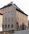
- The Haus Schulenburg (Schulenburg House) at Straße des Friedens is a factory owner's mansion, built in 1913/14 by the famous architect Henry van de Velde. It hosts topical furniture and decoration and can be visited.
Image gallery
-
 Orangerie
 -
 Otto Dix House
 -
 Museum for Applied Arts
 -
 Natural History Museum
 -
 City museum
 -
 Schulenburg House


Cityscape
Like its western neighbour-city Jena, Gera is a protracted city along a wide valley in south-northern direction. The historic city centre is quite small and located between Sorge in the north, Nicolaistraße in the east, Stadtgraben in the south and Reichsstraße in the west. It survived World War II, but during the 1960s and 1970s, the GDR government demolished larger inner-city areas to rebuild them with modern concrete architecture, which marks the view of Gera's centre, particularly in the north-west until today. Between 1870 and 1930, the city was largely extended in all directions. As distinct from other German cities, there is no citywide spatial separation between the worker's quarters and the upper-class mansion districts, instead, the mansions and the tenements are situated near to each other, spread over all the districts. The hilly areas and those next to the river and the parks are more upscale, whereas the areas next to the railway and the factories are more working-class styled. Nevertheless, the Gründerzeit architecture is quite diverse and interesting in Gera. Most buildings were extensively refurbished after 1990. Especially Gera's mansion architecture from the 1900s and 1910s is unique. The 1920s brought some modern-style Bauhaus buildings to the then rich city. During the GDR period, urban growth was handled by establishing big Plattenbau settlements on the city's periphery, like the Lusan district in south and the Bieblach district in north.
Zdroj:https://en.wikipedia.org?pojem=LiebschwitzText je dostupný za podmienok Creative Commons Attribution/Share-Alike License 3.0 Unported; prípadne za ďalších podmienok. Podrobnejšie informácie nájdete na stránke Podmienky použitia.
Antropológia
Aplikované vedy
Bibliometria
Dejiny vedy
Encyklopédie
Filozofia vedy
Forenzné vedy
Humanitné vedy
Knižničná veda
Kryogenika
Kryptológia
Kulturológia
Literárna veda
Medzidisciplinárne oblasti
Metódy kvantitatívnej analýzy
Metavedy
Metodika
Text je dostupný za podmienok Creative
Commons Attribution/Share-Alike License 3.0 Unported; prípadne za ďalších
podmienok.
Podrobnejšie informácie nájdete na stránke Podmienky
použitia.
www.astronomia.sk | www.biologia.sk | www.botanika.sk | www.dejiny.sk | www.economy.sk | www.elektrotechnika.sk | www.estetika.sk | www.farmakologia.sk | www.filozofia.sk | Fyzika | www.futurologia.sk | www.genetika.sk | www.chemia.sk | www.lingvistika.sk | www.politologia.sk | www.psychologia.sk | www.sexuologia.sk | www.sociologia.sk | www.veda.sk I www.zoologia.sk