

A | B | C | D | E | F | G | H | CH | I | J | K | L | M | N | O | P | Q | R | S | T | U | V | W | X | Y | Z | 0 | 1 | 2 | 3 | 4 | 5 | 6 | 7 | 8 | 9
This article needs to be updated. (December 2018) |
Elgeyo Marakwet | |
|---|---|
 Flag | |
 Location in Kenya | |
| Country | Kenya |
| Founded | 4 March 2013 |
| Capital | Iten |
| Government | |
| • Governor | Wisley Rotich |
| Area | |
| • Total | 3,049.7 km2 (1,177.5 sq mi) |
| Population (2019) | |
| • Total | 454,480[1] |
| Time zone | UTC+3 (EAT) |
Elgeyo-Marakwet County is one of Kenya's 47 counties, which is located in the former Rift Valley Province with its capital and largest town as Iten. It borders the counties of West Pokot to the north, Baringo County to the east, southeast and south, Uasin Gishu to the southwest and west, and Trans Nzoia to the northwest.
Demographics
The total population of Elgeyo-Marakwet County is 454,480 persons, of this 227,317 are females, 227,151 males, and 12 intersex persons. There are 99,861 households in the county with an average size of 4.5 persons per household with a density population of 150 persons per square km.[2]
Religion
Religion in Elgeyo-Marakwe County [3]
| Religion (2019 Census) | Number |
|---|---|
| Catholicism | 231,873 |
| Protestant | 144,885 |
| Evangelical Churches | 46,334 |
| African instituted Churches | 12,461 |
| Orthodox | 256 |
| Other Cristian | 7,394 |
| Islam | 1,142 |
| Hindu | 14 |
| Traditionists | 491 |
| Other | 2,933 |
| Atheists | 5,210 |
| Don't Know | 395 |
| Not Stated | 46 |
Geography, geology and topography


The Kerio River binds the county on the eastern side. From its alluvial plain, the topography gradually rises towards the west. The Elgeyo Escarpment stands out distinctly and causes elevation differences of up to 1,500 m.[4] In the northern and southern parts of the county the topography is rugged, giving way to more subdued relief differences going westwards. The underlying geology mainly consists of gneisses from the Basement System. The Cherangany Hills rise gently to form the western half of the Great Rift Valley and extend northwest in a broken chain to Mount Moroto in Uganda.[5] Non-volcanic in origin, the Cherangany Hills resulted from subsequent erosion of the raised western ridge of the Eastern Rift Valley. The range is approximately 30 miles (48 km) long and 25 miles (40 km) wide and averages 9,000 feet (2,700 metres) in height; its highest point reaches more than 11,000 feet (3,400 metres). Many of the summits are covered with huge groundsels and lobelias. Some of the hills include Kameleogon (3581 m), Chebon (3375 m), Chepkotet (3370 m), Alaleigelat (3350 m) and Sodang (3211 m).[6]
Climate
Temperatures range from a minimum of 12 °C—relatively cool, with mists and occasionally even frost—to a maximum of 22 °C. Rainfall ranges annually from 800 to 2300 mm.
Religion and ethnicity

The county is mainly occupied by Keiyo, Sengwer also called Cherangany and Marakwet are part of the larger ethnic grouping of eight culturally and linguistically related ethnic groups known as the Kalenjin.[7]
Marakwet is a sub-tribe of the Kalenjin. It is made up of the sub-dialects Almoo, Endoow, Markweta (the sub-dialect giving rise to the common name), and Sombirir (Borokot) who presently predominantly live in Marakwet District in the North Rift Valley Province. Some now live in Trans Nzoia East and Uasin Gishu North districts and in other towns.
The name Keiyo or Elgeyo has been used interchangeably to describe the Keiyo people. The latter name is disputed as a corruption of the true name, which was coined by the Uasin-Gishu Maasai, who were the Keiyo's neighbours in the mid-9th century at the western side of Eldoret.[8]
Administrative and Political Units
Elgeyo - Marakwet is divided into 4 sub-counties, 20 county assemblies wards, 68 locations and 199 sub-locations. Below is the distribution of the county assemblies wards.
| Constituency | No. of Wards |
|---|---|
| Marakwet East | 4 |
| Marakwet West | 6 |
| Keiyo North | 4 |
| Keiyo South | 6 |
| TOTAL | 20 |
Source[9]
County government
Wisley Rotich who succeeded Alex Tolgos is currently serving his first term as the county's Governor.[10] William Kisang is the current senator replacing Kipchumba Murkomen who was appointed as Cabinet Secretary for Roads.[11] The County Women Representative is Caroline Jeptoo Ng'elechei,[12] all of the United Democratic Alliance (UDA) Party, an affiliate of the Jubilee Alliance. The county has four constituencies in the National Assembly, and twenty ward seats in its County Assembly. The County Assembly Speaker is Mr. Albert Kochei.
-
 Elgeyo Marakwet Governor Alex Tolgos
 -
 Elgeyo Marakwet senator Onesmus Kipchumba Murkomen
 -
 Elgeyo Marakwet Women Representative Susan Kipketer Chebet


County Executive Committee
| Person | Docket |
|---|---|
| Alphaeus Tanui | Finance and Economic Planning |
| Thomas Maiyo | Lands, Physical Planning, Housing and Urban Development |
| Edwin Kibor | Education and Technical Training |
| Robert Kangogo | Co-operatives, Trade, Industrialization, Tourism and Widlife |
| Emmy Kosgei[13] | Roads, Public Works and Transport |
| Michael Kibiwott | Health Services |
| Jason Lagat | Water, Environment and Climate Change |
| Purity Koima | Sports, Youth Affairs, Culture, Children and Social Services |
| Monica Rotich | Public Service, Devolution, Administration, Communications, ICT and E-Governance |
| Edwin Seroney | Agriculture, Livestock, Fisheries and Irrigation |
Source [14]
County Ward Representatives
| Constituency | Ward | Representative |
|---|---|---|
| Marakwet East | Kapyego | Hon. Chebet Joseph Kipkorir |
| Marakwet East | Sambirir | Hon. Suter Paul Kipkemoi |
| Marakwet East | Endo | Hon. Kibiwott Jeremiah Kiptum |
| Marakwet East | Embobut/Embulot | Hon. Kipyatich Paul Kipchumba |
| Marakwet West | Lelan | Hon. Kurgat Pricillah Jepkoech |
| Marakwet West | Sengwer | Hon. Kiptoo Asbel Kisang |
| Marakwet West | Cherang'any/Chebororwa | Hon. Kosgei Evans Kimutai |
| Marakwet West | Moiben/Kuserwo | Hon. Kiplagat Hillary Kipchirchir |
| Marakwet West | Kapsowar | Hon. Kipruto Joshua |
| Marakwet West | Arror | Hon. Mutwol Justine kosgei |
| Keiyo North | Kamariny | Hon. Cheptiony Benjamin Kipkemboi |
| Keiyo North | Emsoo | Hon. Cheboiboch Christopher Kangogo |
| Keiyo North | Tambach | Hon. Chesire Dominic |
| Keiyo North | Kapchemutwa | Hon. Cheruiyot Stephen Kemboi |
| Keiyo South | Kaptarakwa | Hon. Kimutai Mathew Cheruiyot |
| Keiyo South | Chepkorio | Hon. Koima John Kimeli |
| Keiyo South | Soy North | Hon. Chepseba Simeon Kibet |
| Keiyo South | Soy South | Hon. Tanui Jonah Kipkorir |
| Keiyo South | Kabiemit | Hon. Barsulai Alfred Kipkoech |
| Keiyo South | Metkei | Hon. Kibire Lawi Kipng’etich |
| Nominated | Kaptarakwa | Hon. Kimutai Mathew Cheruiyot |
| Nominated | Gender | Hon. Kiptoo Evalyne Jepchumba |
| Nominated | Gender | Hon. Kiptoo Peris Jelagat |
| Nominated | Gender | Hon. Kimitto Salina Jemosop |
| Nominated | Gender | Hon. Rotich Jebet Eddah |
| Nominated | Gender | Hon. Karen Jelagat Koech |
| Nominated | Gender | Hon. Kimoning Tabitha Jepkirui |
| Nominated | Gender | Hon. Kosgei Sally Jebet |
| Nominated | Youth | Hon. Nge'tich Gilbert Kipkosgei |
| Nominated | Youth | Hon. Bowen Stella |
| Nominated | Gender | Hon. Cherop Rosa |
| Nominated | PWD | Hon. Lai victoria Jemutai |
| Nominated | PWD | Hon. Biwott Davies Kimutai |
Health
The county has over 130 public and private health facilities with an averages of 3.7 km access distance from one health centre to another.[17] The county has 626 medical personnels across the fields of medical profession.[18][19]
Transport and Communication
The region is covered with 292.1 km of earth, 1,415.3 km of murram and 92.2 km of bitumen.[when?][20][21] As at 2014 there were 8 postal offices across the county with 1,600 installed letter boxes, 1,112 rented letter boxes and 488 vacant letter boxes.[22]
Economy
The main economic activity carried out in the county is mixed farming, which consists mainly of livestock and subsistence farming. Other activities include small business, tourism and fluorspar mining in Kerio Valley. Oil Prospecting by Tullow Oil Company is ongoing in Kerio Valley.[23]
As at 2014 county had 62,190,000 cattle, 7,220,000 goats and 10,232,000 sheep.[24]
Tourism
Major Tourist Attractions are
- Kerio Valley National Reserve
- Elgeyo Escarpment
- Sports Tourism
- Paragliding
- Cherang'any Hills
- River Kerio
- Rimoi National Reserve
- Torok waterfalls
- Chebara Dam
- Sergoit Hill
- Lake Kapnarok
- Kiplachoch caves
- Mount Kipkunur
- Cheploch Gorge
- Kipteber Meteorite Historical Mountain
- Kureswo Hotsprings
-
 Kerio river
 -
 Cheploch gorge
 -
 Elgeyo escapment
 -
 Elgeyo marakwet valley
 -
 Torok waterfall
 -
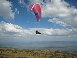 Paragliding in Kerio Escarpment near Iten.
 -
 Rimoi National Park
 -
 Sergoit hill


Education systems
There are a total of 554 ECD centres, 418 primary schools and 112 secondary schools, 4 public technical and vocational colleges and 1 teacher training college in the county.
| Category | No. of Public | No. of Private | Total |
|---|---|---|---|
| ECD Centres | 427 | 127 | 554 |
| Primary Schools | 367 | 51 | 418 |
| Secondary Schools | 111 | 1 | 113 |
| Indicator | Statistics |
|---|---|
| Number of Institutions (2007) | Primary (373), Secondary (75) |
| Primary | Enrolment (110,399) |
| Teacher to Pupil Ratio | 1: 36 (Public Schools) |
| Secondary | Enrolment (20,887) |
| Teacher to Pupil Ratio | 1:30 (Public Schools) |
| Tertiary | 1 Teacher Training College, 3 Vocational Training Centers |
| Adult Literacy Classes | Enrolment (Data Not available) |
Notable Secondary Schools
|
Health
| Indicator | Statistics |
|---|---|
| Health Facilities: | 113 - Referral Hospitals (1), District Hospital (1), Sub-District Hospitals (5), Dispensaries (89), Health Centres (15), Medical Clinics (1), Others (1) |
| Doctor to Population Ratio: | 1:50,000 (Marakwet), 1:156,471 (Keiyo) |
| Infant Mortality Rates: | 57/1000 (Keiyo) |
| Under Five Mortality Rates: | 9.7/1000 (Keiyo) |
| Prevalent Diseases: | Malaria, Diarrhoea, Bronchopneumonia and respiratory tract infections, urinary tract infections |
| Notable Hospitals: |
|
Sports
Major sports activity
The county is notable for its long-standing tradition of producing top athletes who have represented Kenya in many international athletics events.

Notable sport personalities
Notable Athletes hailing from this county include;
Important towns
EMC Towns
- Arror
- Chebiemit
- Chebororwa
- Chepkorio
- Cheptongei
- Chesoi
- Chesongoch
- Chugor
- Flax
- Iten
- Kapchebau
- Kapcherop
- Kapkoi
- Kapsait
- Kapsowar Zdroj:https://en.wikipedia.org?pojem=Elgeyo-Marakwet_County
Text je dostupný za podmienok Creative Commons Attribution/Share-Alike License 3.0 Unported; prípadne za ďalších podmienok. Podrobnejšie informácie nájdete na stránke Podmienky použitia.
Antropológia
Aplikované vedy
Bibliometria
Dejiny vedy
Encyklopédie
Filozofia vedy
Forenzné vedy
Humanitné vedy
Knižničná veda
Kryogenika
Kryptológia
Kulturológia
Literárna veda
Medzidisciplinárne oblasti
Metódy kvantitatívnej analýzy
Metavedy
Metodika
Text je dostupný za podmienok Creative
Commons Attribution/Share-Alike License 3.0 Unported; prípadne za ďalších
podmienok.
Podrobnejšie informácie nájdete na stránke Podmienky
použitia.
www.astronomia.sk | www.biologia.sk | www.botanika.sk | www.dejiny.sk | www.economy.sk | www.elektrotechnika.sk | www.estetika.sk | www.farmakologia.sk | www.filozofia.sk | Fyzika | www.futurologia.sk | www.genetika.sk | www.chemia.sk | www.lingvistika.sk | www.politologia.sk | www.psychologia.sk | www.sexuologia.sk | www.sociologia.sk | www.veda.sk I www.zoologia.sk