

A | B | C | D | E | F | G | H | CH | I | J | K | L | M | N | O | P | Q | R | S | T | U | V | W | X | Y | Z | 0 | 1 | 2 | 3 | 4 | 5 | 6 | 7 | 8 | 9
This article needs additional citations for verification. (February 2010) |
| California county routes in zone S | |
|---|---|
 Example of a California county route shield | |
| Highway names | |
| County | County Route X (CR X) or Route X |
| System links | |
There are 34 routes assigned to the "S" zone of the California Route Marker Program, which designates county routes in California. The "S" zone includes county highways in Imperial, Orange, Riverside, San Diego, and Santa Barbara counties.
S1
County Road S1 | |
|---|---|
| Location | San Diego County |
| Tourist routes | |
County Route S1 (CR S1), also known as Sunrise Highway for a portion of its length, is a 34.08 mi (54.85 km) long county highway located entirely in San Diego County, California, United States. It begins at State Route 94 near Barrett and moves northward across Interstate 8, just west of the Laguna Summit. This segment is also known as Buckman Springs Road. North of I-8, it is the Sunrise Scenic Byway, a National Forest Scenic Byway.[2][3]
- Route description

The route begins at SR 94 near Barrett not far from the Mexican border. From there, it heads northward along Buckman Springs Road. Soon afterwards, it enters the Cleveland National Forest. When the road reaches Interstate 8, while Buckman Springs Road continues northeastward across the freeway, CR S1 continues in a northwest direction along Old Highway 80, the original alignment of U.S. Route 80 in California. It then closely parallels I-8 for several miles. Upon crossing the freeway at Laguna Junction, CR S1 separates from Old Highway 80 and becomes Sunrise Scenic Byway.[4]

From Interstate 8, it begins its ascent into the Laguna Mountains. The route here was built along a cliff overlooking Pine Valley to its west. Around here, the vegetation still consists of chaparral and sagebrush.[5] As the route gains elevation through Cleveland National Forest, the route becomes more heavily forested. Around here, numerous campgrounds dot the side of the road. There is a picnic area overlooking Anza-Borrego Desert State Park near the Burnt Rancheria Campground, which is often said to deeply contrast the forest scenery along the route.[3] Upon passing the settlement of Mount Laguna, the vegetation along the route mostly consists of dead trees devastated by the 2003 Cedar Fire.
As the route approaches its north end at State Route 79, Lake Cuyamaca is visible. The north terminus is located just north of Cuyamaca Rancho State Park where it meets SR 79.
- History

The route was established by the county in the year 1959, where the entire route was designated as it is now. No major numbering or routing changes occurred throughout its history.[6] The northern segment of the route was also established as a Scenic Byway in 1959.[7]
-
 Map
Map -
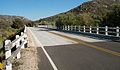 Bridge over Cottonwood Creek
 -
 Buckman Springs Rd. and Old Highway 80
 -
 Bridge over Interstate 8
 -
 Near Al Bahr Shrine Camp
 -
 California Riding and Hiking Trail
 -
 Junction with California Route 79


- Major intersections
The entire route is in San Diego County.
| Location | mi | km | Destinations | Notes | |
|---|---|---|---|---|---|
| | Southern terminus | ||||
| | Buckman Springs Road north (to I-8), Old Highway 80 east | Former US 80 east; north end of Buckman Springs Road on CR S1; south end of Old Highway 80 on CR S1 | |||
| | Interchange; I-8 exit 47 | ||||
| | Old Highway 80 west – Pine Valley | Former US 80 west; north end of Old Highway 80 on CR S1; south end of Sunrise Highway | |||
| | Northern terminus | ||||
| 1.000 mi = 1.609 km; 1.000 km = 0.621 mi | |||||
S2
County Road S2 | |
|---|---|
| Location | San Diego – Imperial Counties |
| Existed | 1970–present[1] |
This section needs expansion. You can help by adding to it. (December 2015) |
County Route S2 (CR S2) is a county highway in the U.S. state of California. It runs for 65 miles (105 km), north–south, in Imperial County and San Diego County. CR S2 is the third longest county route in California and is almost exclusively a two-lane rural road. It largely follows the route of the former Southern Emigrant Trail and Butterfield Overland Mail.
- Route description


Starting at mile marker zero, the highway begins at a junction with State Route 79 near the community of Warner Springs. As it descends southeast toward the desert floor it becomes San Felipe Road until it crosses State Route 78 at Scissors Crossing in Shelter Valley (formerly called Earthquake Valley).[8] South of SR 78, the name of the highway changes to the Great Southern Overland Stage Route of 1849, then further south, it forks at a remote junction with the historic dirt road to become to Sweeney Pass Road. East of the San Diego/Imperial County Line of this segment is also called Imperial Highway. The highway runs south through an interchange with Interstate 8 then ends at a junction with State Route 98 near Ocotillo.
- Images from County Route S2
-
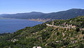
 Agua Caliente Springs, desert landscape and CR S2 going south, in the Anza-Borrego Desert State Park.
 -
 Borrego Springs and the surrounding desert as seen from the descent near the Montezuma Valley Road lookout.
 -
 Scissors crossing seen from the north, along the Pacific Crest Trail.
 -
 Shelter Valley California Fire Department and Community Center on CR S2.
 -
 Warner's Ranch, Ranch House, San Felipe Road (CR S2), Warner Springs.


.jpg)
.jpg)
- Major intersections
| County | Location | mi | km | Destinations | Notes |
|---|---|---|---|---|---|
| Imperial | | Southern terminus | |||
| Ocotillo | Interchange; I-8 exit 89 | ||||
| Former US 80 | |||||
| Imperial–San Diego county line | | North end of Imperial Highway; south end of Sweeny Pass Road | |||
| San Diego | | Great Southern Overland Stage Route of 1849 south | North end of Sweeny Pass Road; south end of Great Southern Overland Stage Route of 1849 on CR S2 | ||
| | South end of SR 78 overlap; north end of Great Southern Overland Stage Route of 1849 | ||||
| | North end of SR 78 overlap; south end of San Felipe Road | ||||
| | Western terminus of CR S22 | ||||
| | Northern terminus | ||||
1.000 mi = 1.609 km; 1.000 km = 0.621 mi
| |||||
S3
County Road S3 | |
|---|---|
| Location | San Diego County |
This section needs expansion. You can help by adding to it. (March 2010) |
County Route S3 (CR S3) is a county highway in San Diego County, California, United States. It begins at a junction with State Route 78 and runs roughly north over Yaqui Pass to Borrego Springs, bearing the name Yaqui Pass Road. It turns left onto Deep Well Trail and left again onto Borrego Springs Road. It ends at a junction with County Route S22 at a large roundabout known as Christmas Circle. Its total length is 12.1 miles (19.5 km).
There is one call box on this highway, located at Yaqui Pass summit.
The highway is part of the Juan Bautista de Anza National Historic Trail Auto Tour Route.
-
 Junction with State Route 78
 -

-


- Major intersections
The entire route is in San Diego County.
| Location | mi | km | Destinations | Notes | |
|---|---|---|---|---|---|
| | Southern terminus | ||||
| | Yaqui Pass Road north – Borrego Valley Airport | North end of Yaqui Pass Road on CR S3; south end of Deep Well Trail | |||
| | North end of Deep Well Trail; south end of Borrego Springs Road on CR S3 | ||||
| Borrego Springs | Roundabout; northern terminus; road continues north as Borrego Springs Road | ||||
| 1.000 mi = 1.609 km; 1.000 km = 0.621 mi | |||||
S4
County Road S4 | |
|---|---|
| Poway Road | |
| Location | San Diego County |
This section needs expansion. You can help by adding to it. (February 2010) |
County Route S4 (CR S4) is a road in San Diego County, California, United States, in the northern city limits of San Diego and in the city of Poway. United States. The route is traversed entirely by Poway Road from Interstate 15 east to State Route 67.
The route's western terminus is at I-15, where the road continues west as Rancho Penasquitos Boulevard, traverses across SR 56, and finally ends as Carmel Mountain Road. Eastward, the road traverses through the city of Poway as Poway Road and has its east end at SR 67. Within Poway, it is one of the busiest streets in the city.
The route was established in 1959.
- Major intersections
The entire route is in San Diego County.
| Location | mi | km | Destinations | Notes | |
|---|---|---|---|---|---|
| San Diego | Interchange; western terminus; I-15 exit 18; road continues west as Rancho Penasquitos Boulevard | ||||
| Sabre Springs Parkway | |||||
| Poway | Pomerado Road | ||||
| Community Road | |||||
| Southern terminus of CR S5 | |||||
| Eastern terminus | |||||
| 1.000 mi = 1.609 km; 1.000 km = 0.621 mi | |||||
S5
County Road S5 | |
|---|---|
| Location | San Diego County |
This section needs expansion. You can help by adding to it. (February 2010) |
County Route S5 (CR S5) is a road in San Diego County, California, United States, in Poway and San Diego. It runs from its southern end at Poway Road (County Route S4) in Poway to its northern end at Interstate 15 in San Diego.
- Route description
The road's south end is at Poway Road (CR S4) in Poway. It winds north through Poway as Espola Road and then turns slightly west, ending at Interstate 15 as Rancho Bernardo Road (which continues past I-15).
The route was established in 1959.
- Major intersections
The entire route is in San Diego County.
| Location | mi | km | Destinations | Notes | |
|---|---|---|---|---|---|
| Poway | Southern terminus | ||||
| Twin Peaks Road | |||||
| Chabad Way | North end of Espola Road; south end of Rancho Bernardo Road | ||||
| San Diego | Pomerado Road | ||||
| Bernardo Center Drive | |||||
| Interchange; northern terminus; I-15 exit 24; road continues west as Rancho Bernardo Road | |||||
| 1.000 mi = 1.609 km; 1.000 km = 0.621 mi | |||||
S6
County Road S6 | |
|---|---|
| Location | San Diego County |
This section needs expansion. You can help by adding to it. (February 2010) |
County Route S6 (CR S6) is a county highway in San Diego County, California, United States. It connects Del Mar with Palomar Mountain across San Diego County. It is one of a few San Diego county routes with a discontinuity in its routing.

- Route description
CR S6 starts at CR S21 in Del Mar as Via de la Valle. It crosses Interstate 5 and meets with CR S8 in Rancho Santa Fe at the intersection of Via de la Valle and Paseo Delicias. At El Camino Del Norte, the name changes to Del Dios Highway, past the community of Del Dios and into Escondido.
In Escondido, CR S6 runs along West and East Valley Parkways, to Valley Center Road through Valley Center. CR S6 ends at State Route 76.
About four miles (6.4 km) east on SR 76, CR S6 begins again as South Grade Road, which winds northward on Palomar Mountain. It intersects with CR S7, then continues north until it ends at the Palomar Observatory.

The route was defined in 1959.
- Major intersections
The entire route is in San Diego County.
| Location | mi | km | Destinations | Notes | |
|---|---|---|---|---|---|
| Solana Beach–Del Mar line | Western terminus; former US 101; road continues west as Border Avenue | ||||
| Jimmy Durante Boulevard, Valley Avenue – Del Mar Fairgrounds, Del Mar Racetrack | |||||
| San Diego | Interchange; I-5 exit 36 | ||||
| San Andres Drive | |||||
| El Camino Real south | |||||
| El Camino Real north | |||||
| Rancho Santa Fe | Calzada del Bosque | ||||
| Via de Santa Fe south | |||||
| Via de Santa Fe north – Rancho Santa Fe | |||||
| Eastern terminus of CR S8; north end of Via de la Valle; south end of Paseo Delicias on CR S6 | |||||
| La Valle Plateada, El Montevideo | |||||
| El Camino Del Norte | North end of Paseo Delicias; south end of Del Dios Highway | ||||
| | Via Rancho Parkway | ||||
| Escondido | North end of Del Dios Highway; south end of Valley Parkway | ||||
| Citracado Parkway | |||||
| Auto Park Way | |||||
| Interchange; I-15 exit 31 | |||||
| Tuilp Avenue | Left exit westbound only interchange; at-grade intersection eastbound; no left turn from Tulip Avenue to CR S6 west; CR S6 east transitions onto Grand Avenue; west end of one-way couplet | ||||
| Grand Avenue | Left exit eastbound only interchange; CR S6 east transitions onto 2nd Avenue | ||||
| Former US 395 | |||||
| Broadway | |||||
| To Grand Avenue (2nd Avenue) | Interchange; eastbound exit and entrance; CR S6 east transitions onto Valley Boulevard | ||||
| Grand Avenue | |||||
| Hickory Street | East end of one-way couplet; CR S6 east transitions onto Valley Parkway | ||||
| Rose Street | |||||
| Midway Drive | |||||
| Citrus Avenue | |||||
| Bear Valley Parkway | |||||
| El Norte Parkway, Hidden Trails Road | |||||
| Lake Wohlford Road | East end of Valley Parkway; west end of Valley Center Road | ||||
| Valley Center | Woods Valley Road | ||||
| Lilac Road | |||||
| Cole Grade Road – Pauma Valley | |||||
| North Lake Wohlford Road, Thundernut Lane – San Pasqual Indian Reservation, Lake Wohlford | |||||
| Rincon | West end of SR 76 overlap; east end of Valley Center Road | ||||
| | East end of SR 76 overlap; west end of South Grade Road | ||||
| | West end of CR S7 overlap; east end of South Grade Road; west end of East Grade Road on CR S6 | ||||
| | East end of CR S7 overlap and East Grade Road; west end of Canfield Road | ||||
| | Palomar Observatory | Eastern terminus | |||
1.000 mi = 1.609 km; 1.000 km = 0.621 mi
| |||||
S7
County Road S7 | |
|---|---|
| Location | San Diego County |
This section needs expansion. You can help by adding to it. (February 2010) |
County Route S7 (CR S7) is a county highway in San Diego County, California, United States, that provides access to Palomar Mountain.
- Route description
CR S7's western terminus is at State Route 76 east of Pauma Valley, California. It begins as a dirt road known as the Nate Harrison Grade. Then it returns to pavement as it ascends Palomar Mountain and meets San Diego County Route S6. It enters Palomar Mountain State Park. Then, it descends to end at SR 76 near Lake Henshaw.
Nate Harrison Grade is not signed as County Route S7, but it is a logical westward extension of the signed portion. With a 10% grade, it was the only road to the top of Palomar Mountain until the 1940s, when East Grade Road ("Highway to the Stars") was built for the construction of the Palomar Observatory. The road was formerly known as "Nigger Nate Road", named after Nate Harrison, an early African-American homesteader. The name was changed in 1956 at the request of the NAACP.[9][10][11][12][13][14]
On a small turnout is a monument to Gregory Pacheco and a good view to the north. According to a plaque at the monument, pictured below, Gregory Pacheco was a firefighter who died in the La Jolla Fire in 1999. The descent on the eastern side of Palomar Mountain offers panoramic views of Lake Henshaw.
-
 East end on Highway 76
 -
 Lake Henshaw from lookout on County Highway S7
 -
 Gregory Pacheco monument
 -
 Gregory Pacheco monument
 -
 West end at entrance to Palomar Mountain State Park


- Major intersections
The entire route is in San Diego County.
| Location | mi | km | Destinations | Notes | |
|---|---|---|---|---|---|
| | Palomar Mountain State Park | Western terminus; road continues into the park, then connects with the Nate Harrison Grade | |||
| | West end of CR S6 overlap; east end of State Park Road; west end of East Grade Road | ||||
| | East end of CR S6 overlap | ||||
| | Eastern terminus | ||||
1.000 mi = 1.609 km; 1.000 km = 0.621 mi
| |||||
S8
County Road S8 | |
|---|---|
| Location | Solana Beach–Rancho Santa Fe |
| Length | 5.3 mi[15] (8.5 km) |
| Existed | 1959–present[1] |
County Route S8 (CR S8) is a county highway, mostly along Lomas Santa Fe Drive and Linea Del Cielo, in San Diego County, California, United States. Its western end is CR S21 (locally signed as "Highway 101") in Solana Beach and its eastern end is at Via De La Valle in Rancho Santa Fe.
- Route description
The route begins in Solana Beach at Old Highway 101. It winds eastward through San Diego County, crossing through Solana Beach and unincorporated San Diego County, and ends at Via De La Valle (CR S6) in Rancho Santa Fe. The last portion of the county road passes through Rancho Santa Fe on Paseo Delicias.[15]
- Major intersections
The entire route is in San Diego County.
| Location | mi | km | Destinations | Notes | |
|---|---|---|---|---|---|
| Solana Beach | 0.0 | 0.0 | Western terminus; historic and former US 101; road continues west as Plaza Street | ||
| 1.0 | 1.6 | Interchange; I-5 exit 37 | |||
| | 3.0 | 4.8 | El Camino Real | ||
| Rancho Santa Fe | La Floresta | East end of Lomas Santa Fe Drive; west end of Linea Del Cielo | |||
| 5.3 | 8.5 | Eastern terminus of CR S9 | |||
| 5.5 | 8.9 | Eastern terminus | |||
| 1.000 mi = 1.609 km; 1.000 km = 0.621 mi | |||||
S9
County Road S9 | |
|---|---|
| Location | Encinitas–Rancho Santa Fe |
| Length | 6.5 mi[16] (10.5 km) |
| Existed | 1959–present[1] |
This section needs expansion. You can help by adding to it. (February 2010) |
County Route S9 (CR S9), mostly known as Encinitas Boulevard, is a road in San Diego County, California, United States. Its west end is at CR S21 (Coast Highway 101) in Encinitas and its east end is at Paseo Delicias (CR S6) in Rancho Santa Fe.
Once outside Encinitas, the county route follows portions of Rancho Santa Fe Road, La Bajada, Los Morros, and La Granada, before terminating at Paseo Delicias.[16]
- Major intersections
The entire route is in San Diego County.
| Location | mi[16] | km | Destinations | Notes | |
|---|---|---|---|---|---|
| Encinitas | 0.0 | 0.0 | Western terminus; historic and former US 101; road continues west as B Street | ||
| 0.4 | 0.64 | Interchange; I-5 exit 41B | |||
| 2.2 | 3.5 | Southern terminus of CR S10 | |||
| 3.7 | 6.0 | Southern terminus of CR S11 | |||
| | 4.0 | 6.4 | El Mirlo | East end of Encinitas Boulevard; west end of La Bajada | |
| | 4.5 | 7.2 | Los Morros east | East end of La Bajada; west end of Los Morros on CR S9 | |
| | 4.9 | 7.9 | Los Morros west | East end of Los Morros on CR S9; west end of La Granada | |
| Rancho Santa Fe | 6.5 | 10.5 | Eastern terminus; road continues as La Granada | ||
| 1.000 mi = 1.609 km; 1.000 km = 0.621 mi | |||||
S10
County Road S10 | |
|---|---|
| Rancho Santa Fe Road | |
| Location | Encinitas–San Marcos |
| Length | 9.7 mi[17] (15.6 km) |
| Existed | 1959–present[1] |
County Route S10 (CR S10), known entirely as Rancho Santa Fe Road, is a road in San Diego County, California, United States, that runs through the North County region of San Diego County.
- Route description
CR S10 begins at Encinitas Boulevard in Encinitas, heading in a generally northward direction. It enters Carlsbad and turns eastward. This road travels into San Marcos and passes near the unincorporated area of Lake San Marcos. (The entire run of the road past Carlsbad is located in parts of the incorporated city of San Marcos; often, at this point, the incorporated portions only follow the road, leaving unincorporated islands nearby). Rancho Santa Fe Road intersects with San Marcos Boulevard and continues northward. There is a junction with State Route 78. A short distance north, Rancho Santa Fe ends at County Route S14 (which changes names from Santa Fe Avenue to Mission Road at the intersection).
- Major intersections
The entire route is in San Diego County.
| Location | mi[17] | km | Destinations | Notes | |
|---|---|---|---|---|---|
| Encinitas | 0.0 | 0.0 | Southern terminus; road continues south as Manchester Avenue | ||
| San Marcos | 8.0 | 12.9 | |||
| 9.4 | 15.1 | Interchange; SR 78 exit 11A | |||
| 9.7 | 15.6 | Northern terminus | |||
| 1.000 mi = 1.609 km; 1.000 km = 0.621 mi | |||||
S11
County Road S11 | |
|---|---|
| El Camino Real | |
| Location | Encinitas–Oceanside |
| Length | 11.6 mi[18] (18.7 km) |
| Existed | 1959–present[1] |
County Route S11 (CR S11), known entirely as El Camino Real, is a county route in San Diego County, California, United States. It runs through the North County region in San Diego County, from Encinitas Boulevard (County Route S9) in Encinitas to State Route 78 in Oceanside. As its street name implies, it is part of the 600-mile (965-kilometer) commemorative route connecting the 21 Spanish missions in California (formerly Alta California).
- Route description
CR S11's southern terminus is Encinitas Boulevard (CR S9) in Encinitas. It continues northward through Encinitas, intersecting with Lecuadia Boulevard/Olivenhain Road, which leads to CR S10 (Rancho Santa Fe Road) east of this intersection. After this point, it enters Carlsbad, where it intersects with Palomar Airport Road (CR S12). It continues northward through Carlsbad, ending at State Route 78 in Oceanside.
Note that El Camino Real continues for several miles beyond both termini. It extends southward through Encinitas until it reaches San Elijo Lagoon and ends at Manchester Avenue. An unconnected road further east also called El Camino Real starts at the San Elijo Lagoon and continues south for several miles until Carmel Mountain Road. Northward in Oceanside, El Camino Real passes under State Route 76 and ends just north at Douglas Drive.
- Major intersections
The entire route is in San Diego County.
| Location | mi[18] | km | Destinations | Notes | |
|---|---|---|---|---|---|
| Encinitas | 0.0 | 0.0 | Continuation beyond CR S9 | ||
| 0.0 | 0.0 | Southern terminus | |||
| 1.5 | 2.4 | Leucadia Boulevard, Olivenhain Road | |||
| Carlsbad | 2.8 | 4.5 | La Costa Avenue | ||
| 4.0 | 6.4 | Aviara Parkway, Alga Road | |||
| 4.6 | 7.4 | Poinsettia Lane | |||
| 6.1 | 9.8 | ||||
| 7.5 | 12.1 | College Boulevard | |||
| 8.4 | 13.5 | Cannon Road | |||
| 9.4 | 15.1 | Tamarack Avenue | |||
| 10.8 | 17.4 | Carlsbad Village Drive | |||
| Oceanside | 11.6 | 18.7 | Interchange; northern terminus; SR 78 exit 2; road continues north as El Camino Real | ||
| 1.000 mi = 1.609 km; 1.000 km = 0.621 mi | |||||
S12
County Road S12 | |
|---|---|
| Location | San Diego County |
| Length | 15.51 mi[19] (24.96 km) |
| Existed | 1961–present[19] |
This section needs expansion. You can help by adding to it. (February 2010) |
County Route S12 (CR S12), also known as Palomar Airport Road, San Marcos Boulevard, Twin Oaks Valley Road, and Deer Springs Road, is a county highway in San Diego County, California, United States. It runs through the North County region of San Diego County from Carlsbad Boulevard (County Route S21) in Carlsbad to Interstate 15 near Hidden Meadows.
- Route description
CR S12's western terminus is at Carlsbad Boulevard (CR S21) in Carlsbad. Almost immediately after it begins, CR S12 (this portion of which is called Palomar Airport Road) intersects with Interstate 5. It passes Legoland California and continues eastward, passing its namesake, McClellan–Palomar Airport. It intersects with El Camino Real (CR S11) before running through a number of industrial and business parks. Eventually, CR S12 enters San Marcos, where it becomes San Marcos Boulevard after an intersection with Business Park Drive. San Marcos Boulevard intersects Rancho Santa Fe Road (CR S10) and continues eastward, crossing State Route 78. Shortly thereafter, San Marcos Boulevard intersects with Twin Oaks Valley Road, which assumes the S12 designation after this junction. Shortly after becoming CR S12, Twin Oaks Valley Road passes over Mission Road (CR S14) without actually intersecting it, then continues to the northern city limits of San Marcos. At the edge of the city, Twin Oaks Valley Road narrows into a private road, and CR S12 bears right to become Deer Springs Road, which continues northward through unincorporated land. Eventually the road turns east, and CR S12 ends at an interchange with Interstate 15, though the road itself continues as Mountain Meadow Road through Hidden Meadows.
The route was established in 1961.
- Major intersections
The entire route is in San Diego County.
| Location | mi | km | Destinations | Notes | |
|---|---|---|---|---|---|
| Carlsbad | Interchange; western terminus; former US 101 | ||||
| Avenida Encinas | |||||
| Interchange; I-5 exit 47 | |||||
| Paseo Del Norte | |||||
| Flower Fields | Interchange; westbound exit only | ||||
| College Boulevard, Aviara Parkway | |||||
| El Fuerte Street | |||||
| Melrose Drive – Leo Carrillo Park | |||||
| Carlsbad–San Marcos line | East end of Palomar Airport Road; west end of San Marcos Boulevard | ||||
| San Marcos | |||||
| Las Posas Road, McMahr Road | |||||
| Interchange; SR 78 exit 12 | |||||
| San Marcos Boulevard east, Twin Oaks Valley Road south | East end of San Marcos Boulevard on CR S12; west end of Twin Oaks Valley Road on CR S12; connects to Mission Road (CR S14); serves California State University San Marcos | ||||
| Borden Road | |||||
| Buena Creek Road | |||||
| North Twin Oaks Valley Road | East end of Twin Oaks Valley Road; west end of Deer Springs Road | ||||
| | Interchange; eastern terminus; I-15 exit 37 | ||||
| | Deer Springs Road to Mountain Meadow Road – Hidden Meadows | Continuation beyond I-15 | |||
| 1.000 mi = 1.609 km; 1.000 km = 0.621 mi | |||||
S13
County Road S13 | |
|---|---|
| Location | San Diego County |
This section needs expansion. You can help by adding to it. (February 2010) |
County Route S13 (CR S13), also known as Vista Village Drive, East Vista Way, and Mission Road, is a county highway in San Diego County, California, United States, that runs through the North County region of San Diego County. It is distinctive for having a three-mile (5 km) discontinuity in Bonsall.
- Route description
CR S13's southern terminus is at State Route 78 in Vista, where the street is known as Vista Village Drive. This section of CR S13 is the northern boundary of the newly renovated downtown area of Vista, and in this area the road intersects with Santa Fe Avenue, which is CR S14. Shortly afterwards, the road's name changes to East Vista Way, and continues northward outside the city limits into the unincorporated community of Bonsall.
CR S13 is unusual in that, according to official legislation, its route is discontinuous. In Bonsall, East Vista Way meets State Route 76 and, from this point, loses its status as CR S13. Nearly three miles northeast on SR 76, CR S13 begins again, continuing northward, but as South Mission Road.
Mission Road cuts north through Bonsall and passes the neighborhoods of San Luis Rey Heights and Winterwarm before entering Fallbrook. In Fallbrook, South Mission Road splits off into South Main Avenue, which carries the S13 signage. These two streets run parallel to each other for several blocks; East Fallbrook Road (SR S15) begins at Mission and intersects Main. After a short distance, Mission turns east, intersecting Main; Mission then continues as S13. CR S13 continues eastward, ending at an interchange with Interstate 15.
Almost all of S13, except for later realigned portions, is an old alignment of U.S. Route 395, and Historic Route signs are posted in unincorporated areas.
The route was established in 1968.
- Major intersections
The entire route is in San Diego County.
| Location | mi | km | Destinations | Notes | |
|---|---|---|---|---|---|
| Vista | Interchange; southern terminus; SR 78 east exit 6B, west exit 6; road continues south as Vista Village Drive to Hacienda Drive | ||||
| West Vista Way | |||||
| Civic Center Drive, Hillside Terrace | South end of Vista Village Drive; north end of East Vista Way | ||||
| Vale Terrace Drive, Anza Avenue | |||||
| Foothill Drive, Bobier Drive | |||||
| | |||||
| | South end of SR 76 overlap; north end of East Vista Way | ||||
| | North end of SR 76 overlap; south end of South Mission Road | ||||
| Fallbrook | Ammunition Road | ||||
| Western terminus of CR S15 | |||||
| Hill Street | North end of South Mission Road; south end of West Mission Road | ||||
| Pico Avenue to De Luz Road | |||||
| Main Avenue | North end of West Mission Road; south end of East Mission Road | ||||
| | Stage Coach Lane | ||||
| | Former US 395 south | ||||
| | Interchange; eastern terminus; I-15 exit 51 | ||||
| | Mission Road to Old Highway 395 | Continuation beyond I-15; former US 395 north | |||
1.000 mi = 1.609 km; 1.000 km = 0.621 mi
| |||||
S14
Zdroj:https://en.wikipedia.org?pojem=County_Route_S6_(California)Text je dostupný za podmienok Creative Commons Attribution/Share-Alike License 3.0 Unported; prípadne za ďalších podmienok. Podrobnejšie informácie nájdete na stránke Podmienky použitia.
Antropológia
Aplikované vedy
Bibliometria
Dejiny vedy
Encyklopédie
Filozofia vedy
Forenzné vedy
Humanitné vedy
Knižničná veda
Kryogenika
Kryptológia
Kulturológia
Literárna veda
Medzidisciplinárne oblasti
Metódy kvantitatívnej analýzy
Metavedy
Metodika
Text je dostupný za podmienok Creative
Commons Attribution/Share-Alike License 3.0 Unported; prípadne za ďalších
podmienok.
Podrobnejšie informácie nájdete na stránke Podmienky
použitia.
www.astronomia.sk | www.biologia.sk | www.botanika.sk | www.dejiny.sk | www.economy.sk | www.elektrotechnika.sk | www.estetika.sk | www.farmakologia.sk | www.filozofia.sk | Fyzika | www.futurologia.sk | www.genetika.sk | www.chemia.sk | www.lingvistika.sk | www.politologia.sk | www.psychologia.sk | www.sexuologia.sk | www.sociologia.sk | www.veda.sk I www.zoologia.sk