A | B | C | D | E | F | G | H | CH | I | J | K | L | M | N | O | P | Q | R | S | T | U | V | W | X | Y | Z | 0 | 1 | 2 | 3 | 4 | 5 | 6 | 7 | 8 | 9
Casper, Wyoming | |
|---|---|
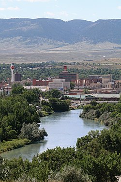
 Overview of downtown, looking south toward Casper Mountain, with North Platte River | |
| Nickname: "The Oil City" | |
| Coordinates: 42°51′0″N 106°19′30″W / 42.85000°N 106.32500°W | |
| Country | United States |
| State | |
| County | Natrona |
| Government | |
| • Type | Council–manager[1] |
| • City Manager | Carter Napier[2] |
| Area | |
| • City | 26.88 sq mi (69.62 km2) |
| • Land | 26.55 sq mi (68.76 km2) |
| • Water | 0.33 sq mi (0.86 km2) |
| Elevation | 5,150 ft (1,560 m) |
| Population | |
| • City | 59,038 |
| • Rank | US: 662nd WY: 2nd |
| • Density | 2,182.21/sq mi (842.55/km2) |
| • Urban | 64,548 (US: 424th) |
| • Metro | 79,955 (US: 378th) |
| Time zone | UTC−7 (MST) |
| • Summer (DST) | UTC−6 (MDT) |
| ZIP Codes | 82601–82602, 82604–82605, 82609, 82615, 82630, 82638, 82646 |
| Area code | 307 |
| FIPS code | 56-13150[5] |
| GNIS feature ID | 1586424[6] |
| Website | casperwy.gov |
Casper is a city in, and the county seat of, Natrona County, Wyoming, United States.[7] Casper is the second-most populous city in the state after Cheyenne, with the population at 59,038 as of the 2020 census.[4] Casper is nicknamed "The Oil City" and has a long history of oil boomtown and cowboy culture, dating back to the development of the nearby Salt Creek Oil Field.
Casper is located in east central Wyoming on the North Platte River.
History
The city was established east of the former site of Fort Caspar, in an area that grew for European settlers during the mid-19th century mass migration of land seekers along the Oregon, California, and Mormon trails,[8] where several nearby ferries offered passage across the North Platte River in the early 1840s. In 1859, Louis Guinard built a bridge and trading post near the original ferry locations, allowing overland travel to continue through the area.[9]
The government also posted the military garrison to protect telegraph and mail service. It was under the command of Lieutenant Colonel William O. Collins.[8] Native American attacks increased after the Sand Creek Massacre in Colorado in 1864, bringing more troops to the post, which was by now called Platte Bridge Station. In July 1865, Lt. Colonel William Collins' beloved son Lieutenant Caspar Collins was killed near the post by a group of Indian warriors, and three months later the garrison was renamed Fort Caspar in his son's honor.[8]
In 1867, the troops were ordered to abandon Fort Caspar in favor of Fort Fetterman, downstream on the North Platte along the Bozeman Trail. However, the town itself was settled twenty years later in 1887, and incorporated a year later by developers as an anticipated stopping point during the expansion of the Wyoming Central Railway.
A site a few miles east was planned as the original site,[10] where homesteader Joshua Stroud lived prior to the actual construction of the train station for the Chicago and North Western Railway.[11][12][13] The site was laid out by the Pioneer Town Site Company in 1888 and was known as Strouds, but the name Casper soon prevailed. While the name is derived from Fort Caspar and Lt. Caspar Collins, it is officially named "Casper" due to a typo occurring during the official registration.
Casper was an early commercial rival to both Bessemer and Douglas, Wyoming. The absence of a railhead doomed Bessemer in favor of Casper, while Douglas, also a railhead, survives to the present day. This rail presence also made Casper the starting off point for the "invaders" in the Johnson County War, since the chartered train carrying the men from Texas stopped at Casper.
In more recent history, the city received a significant influx of visitors during the solar eclipse of August 21, 2017, due to its position along the path of totality.[14]
Geography

Interstate 25, which approaches Casper from the north and east, is the main avenue of transportation to and from the city. The towns immediately adjacent to Casper are Mills, Evansville, and Bar Nunn. Unincorporated areas include Allendale, Dempsey Acres, Red Buttes, Indian Springs, and several others.
According to the United States Census Bureau, the city has a total area of 27.24 square miles (70.55 km2), of which 26.90 square miles (69.67 km2) is land and 0.34 square miles (0.88 km2) is water.[15]
Climate
Casper, as with most of the rest of Wyoming, has a continental semi-arid climate (Köppen climate classification: BSk), with long, cold, but dry winters, hot but generally dry summers, mild springs, and short and crisp autumns. Normal daily maxima range from 35.2 °F (1.8 °C) in January to 89.0 °F (31.7 °C) in July. Snow can fall heavily during the winter and early to mid-spring months, and usually falls in May and October. Precipitation is greatest in spring and early summer, but even then it is not high. Highs reach 90 °F (32.2 °C) on 37.8 days per year and fail to surpass freezing on 41.3. Lows drop to 0 °F (−17.8 °C) on an average of 14.6 nights annually. The highest temperature recorded in Casper was 104 °F (40.0 °C) on July 12, 1954, July 16, 2005, and July 29, 2006, while the lowest temperature recorded was −42 °F (−41.1 °C) on December 22, 2022.[16]
| Climate data for Casper, Wyoming (Casper-Natrona County International Airport), 1991–2020 normals, extremes 1948–present | |||||||||||||
|---|---|---|---|---|---|---|---|---|---|---|---|---|---|
| Month | Jan | Feb | Mar | Apr | May | Jun | Jul | Aug | Sep | Oct | Nov | Dec | Year |
| Record high °F (°C) | 60 (16) |
68 (20) |
77 (25) |
84 (29) |
95 (35) |
102 (39) |
104 (40) |
102 (39) |
100 (38) |
87 (31) |
73 (23) |
66 (19) |
104 (40) |
| Mean maximum °F (°C) | 50.8 (10.4) |
55.1 (12.8) |
68.1 (20.1) |
76.9 (24.9) |
85.4 (29.7) |
94.3 (34.6) |
99.1 (37.3) |
96.9 (36.1) |
91.9 (33.3) |
80.1 (26.7) |
65.7 (18.7) |
52.8 (11.6) |
99.5 (37.5) |
| Mean daily maximum °F (°C) | 35.2 (1.8) |
37.8 (3.2) |
48.8 (9.3) |
56.3 (13.5) |
66.8 (19.3) |
79.6 (26.4) |
89.0 (31.7) |
86.7 (30.4) |
75.6 (24.2) |
59.7 (15.4) |
45.9 (7.7) |
34.7 (1.5) |
59.7 (15.4) |
| Daily mean °F (°C) | 25.1 (−3.8) |
26.6 (−3.0) |
35.8 (2.1) |
42.3 (5.7) |
52.0 (11.1) |
62.5 (16.9) |
71.0 (21.7) |
69.0 (20.6) |
58.9 (14.9) |
45.3 (7.4) |
34.0 (1.1) |
24.8 (−4.0) |
45.6 (7.6) |
| Mean daily minimum °F (°C) | 15.0 (−9.4) |
15.4 (−9.2) |
22.7 (−5.2) |
28.2 (−2.1) |
37.1 (2.8) |
45.4 (7.4) |
53.0 (11.7) |
51.4 (10.8) |
42.2 (5.7) |
30.9 (−0.6) |
22.0 (−5.6) |
14.8 (−9.6) |
31.5 (−0.3) |
| Mean minimum °F (°C) | −12.2 (−24.6) |
−10.0 (−23.3) |
3.3 (−15.9) |
13.8 (−10.1) |
24.5 (−4.2) |
37.4 (3.0) |
42.9 (6.1) |
40.0 (4.4) |
29.1 (−1.6) |
13.9 (−10.1) |
−2.6 (−19.2) |
−11.5 (−24.2) |
−20.8 (−29.3) |
| Record low °F (°C) | −40 (−40) |
−32 (−36) |
−25 (−32) |
−6 (−21) |
16 (−9) |
25 (−4) |
30 (−1) |
29 (−2) |
16 (−9) |
−9 (−23) |
−27 (−33) |
−42 (−41) |
−42 (−41) |
| Average precipitation inches (mm) | 0.49 (12) |
0.56 (14) |
0.84 (21) |
1.41 (36) |
2.21 (56) |
1.34 (34) |
1.19 (30) |
0.79 (20) |
0.95 (24) |
1.19 (30) |
0.64 (16) |
0.61 (15) |
12.22 (308) |
| Average snowfall inches (cm) | 9.0 (23) |
10.9 (28) |
10.3 (26) |
10.5 (27) |
2.6 (6.6) |
0.1 (0.25) |
0.0 (0.0) |
0.0 (0.0) |
1.5 (3.8) |
7.0 (18) |
8.9 (23) |
11.0 (28) |
71.8 (183.65) |
| Average precipitation days (≥ 0.01 in) | 6.0 | 6.9 | 8.0 | 10.3 | 11.0 | 8.5 | 6.8 | 5.8 | 6.8 | 7.6 | 6.2 | 7.0 | 90.9 |
| Average snowy days (≥ 0.1 in) | 6.1 | 7.5 | 6.8 | 6.0 | 1.6 | 0.0 | 0.0 | 0.0 | 0.5 | 3.8 | 5.6 | 7.6 | 45.5 |
| Mean monthly sunshine hours | 204.6 | 172.3 | 269.7 | 300.0 | 334.8 | 354.0 | 368.9 | 368.9 | 333.0 | 217.0 | 204.0 | 198.4 | 3,325.6 |
| Mean daily sunshine hours | 6.6 | 6.1 | 8.7 | 10 | 10.8 | 11.8 | 11.9 | 11.9 | 11.1 | 7 | 6.8 | 6.4 | 9.1 |
| Mean daily daylight hours | 9.5 | 10.6 | 12.0 | 13.4 | 14.7 | 15.3 | 15.0 | 13.9 | 12.5 | 11.0 | 9.7 | 9.1 | 12.2 |
| Percent possible sunshine | 69 | 58 | 73 | 75 | 73 | 77 | 79 | 86 | 89 | 64 | 70 | 70 | 74 |
| Average ultraviolet index | 2 | 2 | 2 | 2 | 5 | 6 | 6 | 6 | 4 | 2 | 2 | 2 | 3 |
| Source 1: NOAA,[17] Weather Atlas (sun data)[18] | |||||||||||||
| Source 2: National Weather Service[16] | |||||||||||||
Demographics
| Census | Pop. | Note | %± |
|---|---|---|---|
| 1880 | 40 | — | |
| 1890 | 544 | 1,260.0% | |
| 1900 | 883 | 62.3% | |
| 1910 | 2,639 | 198.9% | |
| 1920 | 11,447 | 333.8% | |
| 1930 | 16,619 | 45.2% | |
| 1940 | 17,964 | 8.1% | |
| 1950 | 23,673 | 31.8% | |
| 1960 | 38,930 | 64.4% | |
| 1970 | 39,361 | 1.1% | |
| 1980 | 51,016 | 29.6% | |
| 1990 | 46,742 | −8.4% | |
| 2000 | 49,644 | 6.2% | |
| 2010 | 55,316 | 11.4% | |
| 2020 | 59,038 | 6.7% | |
| Source:[19][20] | |||
2010 census
As of the census[21] of 2010, there were 55,316 people, 22,794 households, and 14,237 families residing in the city. The population density was 2,056.4 inhabitants per square mile (794.0/km2). There were 24,536 housing units at an average density of 912.1 per square mile (352.2/km2). The racial makeup of the city was 92.3% White, 1.0% African American, 0.9% Native American, 0.8% Asian, 2.3% from other races, and 2.6% from two or more races. Hispanic or Latino people of any race were 7.4% of the population.
There were 22,794 households, of which 31.5% had children under the age of 18 living with them, 46.1% were married couples living together, 11.2% had a female householder with no husband present, 5.2% had a male householder with no wife present, and 37.5% were non-families. Of all households 30.3% were made up of individuals, and 10.1% had someone living alone who was 65 years of age or older. The average household size was 2.38 and the average family size was 2.95.
The median age in the city was 36 years. 23.9% of residents were under the age of 18; 10.2% were between the ages of 18 and 24; 26.7% were from 25 to 44; 26.4% were from 45 to 64; and 12.9% were 65 years of age or older. The gender makeup of the city was 49.7% male and 50.3% female.
2000 census
As of the census[5] of 2000, there were 49,644 people, 20,343 households, and 13,141 families residing in the city. The population density was 2,073.2 people per square mile (800.5 people/km2). There were 21,872 housing units at an average density of 913.4 per square mile (352.7/km2). The racial makeup of the city was 94.03% White, 0.86% Black, 1.00% Native American, 0.49% Asian, 0.02% Pacific Islander, 2.04% from other races, and 1.56% from two or more races. 5.35% of the population were Hispanic or Latino of any race.
There were 20,343 households, out of which 31.8% had children under the age of 18 living with them, 49.6% were married couples living together, 11.1% had a female householder with no husband present, and 35.4% were non-families. Of all households 29.1% were made up of individuals, and 10.2% had someone living alone who was 65 years of age or older. The average household size was 2.38 and the average family size was 2.94.
In the city, the population was spread out, with 25.9% under the age of 18, 10.5% from 18 to 24, 27.7% from 25 to 44, 22.3% from 45 to 64, and 13.6% who were 65 years of age or older. The median age was 36 years. For every 100 females, there were 95.0 males. For every 100 females age 18 and over, there were 91.6 males.
The median income for a household in the city was $36,567, and the median income for a family was $46,267. Males had a median income of $34,905 versus $21,810 for females. The per capita income for the city was $19,409. About 8.5% of families and 11.4% of the population were below the poverty line, including 15.4% of those under age 18 and 7.3% of those age 65 or over.
Economy
Casper is a regional center of banking and commerce.

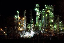
After the discovery of crude oil in the region during the 1890s, Casper became the regional petroleum industry center. Oil has figured prominently in its history from nearly the outset. Oil was first discovered in the famous Salt Creek Oil Field in 1889, approximately 40 miles (64 km) north of Casper; the first refinery in Casper was built in 1895. The city has featured a refinery ever since, although various refineries have been built and closed over the years. As recently as the early 1980s, the city was near or home to three refineries. The surviving one, operated by Sinclair Oil Corporation, is located nearby in Evansville. Development of Wyoming coal and uranium fields in recent decades has helped Casper continue its role as a center in the energy industry.
Casper Wind Farm began operations near Casper in Natrona County and has 11 turbines with a generating capacity of 16.5 MW.[22] Energy Transportation Inc. is headquartered in Casper. This logistics firm transports overweight and outsized components used in the wind power industry.[23] The Casper landfill is also a disposal site for windmill blades.[24]
Education
Casper is home to Casper College, a community college that offers bachelor's degrees in sixteen areas of study from the University of Wyoming through their UW/CC Center.[25]
Zdroj:https://en.wikipedia.org?pojem=Casper_Family_Aquatics_Center
Text je dostupný za podmienok Creative Commons Attribution/Share-Alike License 3.0 Unported; prípadne za ďalších podmienok. Podrobnejšie informácie nájdete na stránke Podmienky použitia.
Antropológia
Aplikované vedy
Bibliometria
Dejiny vedy
Encyklopédie
Filozofia vedy
Forenzné vedy
Humanitné vedy
Knižničná veda
Kryogenika
Kryptológia
Kulturológia
Literárna veda
Medzidisciplinárne oblasti
Metódy kvantitatívnej analýzy
Metavedy
Metodika
Text je dostupný za podmienok Creative
Commons Attribution/Share-Alike License 3.0 Unported; prípadne za ďalších
podmienok.
Podrobnejšie informácie nájdete na stránke Podmienky
použitia.
www.astronomia.sk | www.biologia.sk | www.botanika.sk | www.dejiny.sk | www.economy.sk | www.elektrotechnika.sk | www.estetika.sk | www.farmakologia.sk | www.filozofia.sk | Fyzika | www.futurologia.sk | www.genetika.sk | www.chemia.sk | www.lingvistika.sk | www.politologia.sk | www.psychologia.sk | www.sexuologia.sk | www.sociologia.sk | www.veda.sk I www.zoologia.sk


