

A | B | C | D | E | F | G | H | CH | I | J | K | L | M | N | O | P | Q | R | S | T | U | V | W | X | Y | Z | 0 | 1 | 2 | 3 | 4 | 5 | 6 | 7 | 8 | 9
Tokyo
東京都 | |
|---|---|
| Tokyo Metropolis | |
| Nicknames: | |
| Anthem: "Tokyo Metropolitan Song" (東京都歌, Tōkyō-to Ka) | |
 Interactive map outlining Tokyo | |
 Location within Japan | |
| Coordinates: 35°41′23″N 139°41′32″E / 35.68972°N 139.69222°E | |
| Country | Japan |
| Region | Kantō |
| Island | Honshu |
| Capital | Tokyo[2] |
| Divisions | 23 special wards, 26 cities, 1 district, and 4 subprefectures |
| Government | |
| • Body | Tokyo Metropolitan Government |
| • Governor | Yuriko Koike (Indp.) |
| • Representatives | 42 |
| • Councilors | 11 |
| Area | |
| • Total | 2,194 km2 (847 sq mi) |
| • Metro | 13,452 km2 (5,194 sq mi) |
| • Rank | 45th in Japan |
| Highest elevation | 2,017 m (6,617 ft) |
| Lowest elevation | 0 m (0 ft) |
| Population (2023)[5] | |
| • Total | 14,094,034 |
| • Rank | 1st in Japan |
| • Density | 6,363/km2 (16,480/sq mi) |
| • Urban | 39,105,000 |
| • Metro | 40,800,000 |
| • Metro density | 3,000/km2 (7,900/sq mi) |
| • Dialects | |
| Demonym | Tokyoite |
| GDP [7] | |
| • Total | JP¥109.692 trillion US$1.027 trillion (2020) |
| • Metro | JP¥222.129 trillion US$2.084 trillion (2020) |
| Time zone | UTC+09:00 (Japan Standard Time) |
| ISO 3166-2 | JP-13 |
| Flower | Yoshino cherry |
| Tree | Ginkgo |
| Bird | Black-headed gull |
| Website | tokyotokyo.jp www.metro.tokyo.lg.jp |

.jpg)


Tokyo (/ˈtoʊkioʊ/;[8] Japanese: 東京, Tōkyō, [toːkʲoː] ⓘ), officially the Tokyo Metropolis (東京都, Tōkyō-to), is the capital city of Japan and one of the most populous cities in the world with a population of over 14 million residents as of 2023.[9] Tokyo Metropolitan Area, which includes Tokyo and nearby six prefectures, is the world's first most-populous metropolitan area in the world, with 40.8 million residents as of 2023[update].[10] Tokyo's nominal gross domestic output was 113.7 trillion yen or US$1.04 trillion in FY2021 and accounted for 20.7% of the country's total economic output, which is coverted to 8.07 million yen or US$73,820 per capita.[11] Including the Greater Tokyo Area, Tokyo is the second-largest metropolitan economy in the world after New York, with a 2022 gross metropolitan product estimated at US$2.08 trillion.[12]
Located at the head of Tokyo Bay, Tokyo is part of the Kantō region on the central coast of Honshu, Japan's largest island. Tokyo serves as Japan's economic center and the seat of both the Japanese government and the Emperor of Japan. The Tokyo Metropolitan Government administers Tokyo's central 23 special wards (which formerly made up Tokyo City), various commuter towns and suburbs in its western area, and two outlying island chains known as the Tokyo Islands. Despite most of the world recognising Tokyo as a city, since 1943 its governing structure has been more akin to a prefecture, with an accompanying Governor and Assembly taking precedence over the smaller municipal governments which make up the metropolis. Notable special wards in Tokyo include Chiyoda, the site of the National Diet Building and the Tokyo Imperial Palace, Shinjuku, the city's administrative center, and Shibuya, a commercial, cultural, and business hub in the city.
Before the 17th century, Tokyo, then known as Edo, was mainly a fishing village. It gained political prominence in 1603 when it became the seat of the Tokugawa shogunate. By the mid-18th century, Edo was among the world's largest cities with over a million residents. Following the Meiji Restoration in 1868, the imperial capital in Kyoto was moved to Edo, and the city was renamed Tokyo (lit. 'Eastern Capital'). In 1923, Tokyo was damaged substantially by the Great Kantō earthquake, and the city was later badly damaged by allied bombing raids during World War II. Beginning in the late 1940s, Tokyo underwent rapid reconstruction and expansion that contributed to the era's so-called Japanese economic miracle in which Japan's economy propelled to the second-largest in the world behind that of the United States.[13] As of 2023[update], the city is home to 29 of the world's largest 500 companies listed in the annual Fortune Global 500.[14]
In 20th and 21st centuries, Tokyo has hosted several major international events, including the Summer Olympics and Paralympics in 1964, the postponed-Summer Olympics and Paralympics in 2021, and three G7 summits in 1979, 1986, and 1993. Tokyo is an international research and development hub and an academic center with several major universities, including the University of Tokyo, the top-ranking university in the country.[15][16] Tokyo Station is the central hub for the Shinkansen, Japan's high-speed railway network, and Shinjuku Station in Tokyo is the world's busiest train station. The city is home to the world's tallest tower, Tokyo Skytree.[17] The Tokyo Metro Ginza Line, which opened in 1927, is the oldest underground metro line in Asia-Pacific.[18]
Although Tokyo's status as a leading global financial hub has diminished since the 1990s (the Lost Decades), when the Tokyo Stock Exchange was the world's largest, with a market capitalisation about 1.5 times that of the NYSE,[19] the city is still a large financial hub and the TSE remains among the world's top five major stock exchanges.[20] Tokyo is categorized as an Alpha+ city by the Globalization and World Cities Research Network. Tokyo is recognized as one of the world's most livable cities; it was ranked fourth in the world in Global Livability Ranking, published in 2021.[21]
Etymology
| Tokyo | |||||||
|---|---|---|---|---|---|---|---|
Tōkyō in kanji | |||||||
| Japanese name | |||||||
| Hiragana | とうきょう | ||||||
| Katakana | トウキョウ | ||||||
| Kyūjitai | 東亰 | ||||||
| Shinjitai | 東京 | ||||||
| |||||||
Tokyo was originally known as Edo (江戸), a kanji compound of 江 (e, "cove, inlet") and 戸 (to, "entrance, gate, door").[22] The name, which can be translated as "estuary", is a reference to the original settlement's location at the meeting of the Sumida River and Tokyo Bay. During the Meiji Restoration in 1868, the name of the city was changed to Tokyo (東京, from 東 tō "east", and 京 kyō "capital"), when it became the new imperial capital,[23] in line with the East Asian tradition of including the word capital (京) in the name of the capital city (for example, Kyoto (京都), Keijō (京城), Beijing (北京), Nanjing (南京), and Xijing (西京)).[22] During the early Meiji period, the city was sometimes called "Tōkei", an alternative pronunciation for the same characters representing "Tokyo", making it a kanji homograph. Some surviving official English documents use the spelling "Tokei";[24] however, this pronunciation is now obsolete.[25]
History
Pre-1869 (Edo period)
Tokyo was originally a village called Edo, in what was formerly part of the old Musashi Province. Edo was first fortified by the Edo clan, in the late twelfth century. In 1457, Ōta Dōkan built Edo Castle. In 1590, Tokugawa Ieyasu moved from Mikawa Province (his lifelong base) to the Kantō region. When he became shōgun in 1603, Edo became the center of his ruling. During the subsequent Edo period, Edo grew into one of the largest cities in the world with a population topping one million by the 18th century.[26]
Edo was still the home of the Tokugawa shogunate and was not yet the capital of Japan (the Emperor himself lived in Kyoto almost continuously from 794 to 1868).[27] During the Edo era, the city enjoyed a prolonged period of peace known as the Pax Tokugawa, and in the presence of such peace, the shogunate adopted a stringent policy of seclusion, which helped to perpetuate the lack of any serious military threat to the city.[28] The absence of war-inflicted devastation allowed Edo to devote the majority of its resources to rebuilding in the wake of the consistent fires, earthquakes, and other devastating natural disasters that plagued the city.
This prolonged period of seclusion however came to an end with the arrival of American Commodore Matthew C. Perry in 1853. Commodore Perry forced the opening of the ports of Shimoda and Hakodate, leading to an increase in the demand for new foreign goods and subsequently a severe rise in inflation.[29] Social unrest mounted in the wake of these higher prices and culminated in widespread rebellions and demonstrations, especially in the form of the "smashing" of rice establishments.[30] Meanwhile, supporters of the Emperor leveraged the disruption that these widespread rebellious demonstrations were causing to further consolidate power by overthrowing the last Tokugawa shōgun, Yoshinobu, in 1867.[31] After 265 years, the Pax Tokugawa came to an end.
- Gallery
-
 Edo Castle, 17th century
 -
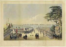 Commodore Matthew Perry expedition and his first arrival in Japan in 1853
 -
 Famous Edo Places. Yamanote (above), Nihonbashi (center) and Shitamachi (below), c. 1858.
 -
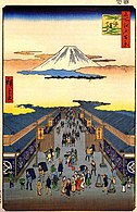 Suruga street with Mount Fuji by Hiroshige (1856)


1869–1943
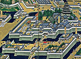
Edo was renamed Tokyo (Eastern Capital) on September 3, 1868, as the new government was consolidating its power after the fall of the Edo shogunate. The young Emperor Meiji visited once at the end of that year and eventually moved in in 1869. Tokyo was already the nation's political center,[32] and the emperor's residence made it a de facto imperial capital as well, with the former Edo Castle becoming the Imperial Palace. The city of Tokyo was officially established on May 1, 1889.
The Tokyo Metro Ginza Line portion between Ueno and Asakusa was the first subway line built in Japan and East Asia completed on December 30, 1927.[18] Central Tokyo, like Osaka, has been designed since about 1900 to be centered on major railway stations in a high-density fashion, so suburban railways were built relatively cheaply at street level and with their own right-of-way. Though expressways have been built in Tokyo, the basic design has not changed.[citation needed]
Tokyo went on to suffer two major catastrophes in the 20th century: the 1923 Great Kantō earthquake, which left 140,000 dead or missing; and World War II.[33]
- Gallery
-
-
 Nihonbashi after Great Kanto Earthquake, 1 September 1923
 -
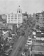 The Ginza area in 1933
 -
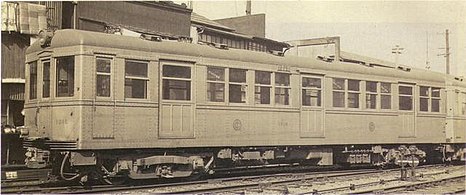 "The first underground railway in the Orient", Tokyo Underground, opened on 30 December 1927


1943–1945
In 1943, the city of Tokyo merged with the prefecture of Tokyo to form the "Metropolitan Prefecture" of Tokyo. Since then, the Tokyo Metropolitan Government served as both the prefecture government for Tokyo, as well as administering the special wards of Tokyo, for what had previously been Tokyo City. World War II wrought widespread destruction of most of the city due to the persistent Allied air raids on Japan and the use of incendiary bombs. The bombing of Tokyo in 1944 and 1945 is estimated to have killed between 75,000 and 200,000 civilians and left more than half of the city destroyed.[34]
The deadliest night of the war came on March 9–10, 1945, the night of the American "Operation Meetinghouse" raid;[35] as nearly 700,000 incendiary bombs rained on the eastern half of the city, mainly in heavily residential wards. Two-fifths of the city were completely burned, more than 276,000 buildings were demolished, 100,000 civilians were killed, and 110,000 more were injured.[36][37] Between 1940 and 1945, the population of Japan's capital city dwindled from 6,700,000 to less than 2,800,000, with the majority of those who lost their homes living in "ramshackle, makeshift huts".[38]
- Gallery
-
 The bombing of Tokyo in 1945
 -
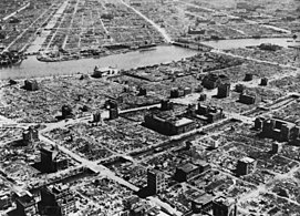 The aftermath of the bombing of Tokyo, March 1945
 -
 Nihonbashi in 1946


1945–present
After the war, Tokyo became the base from which the United States under Douglas MacArthur administered Japan for six years. Tokyo struggled to rebuild as occupation authorities stepped in and drastically cut back on Japanese government rebuilding programs, focusing instead on simply improving roads and transportation. Tokyo did not experience fast economic growth until the 1950s.[39]
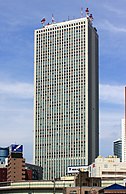
After the occupation of Japan ended in 1952, Tokyo was completely rebuilt and was showcased to the world during the 1964 Summer Olympics. Present in Tokyo then were the Yoyogi National Gymnasium and the 0 Series Shinkansen, the first bullet train of its class in the world. The 1970s and the 1980s brought new high-rise developments. In 1978, Sunshine 60 – the tallest skyscraper in Asia until 1985, and in Japan until 1991[40] – and Narita International Airport were constructed, and the population increased to about 11 million in the metropolitan area.[41] The Edo-Tokyo Open Air Architectural Museum has historic Japanese buildings that existed in the urban landscape of pre-war Tokyo.
Tokyo's subway and commuter rail network became one of the busiest in the world[42] as more and more people moved to the area. In the 1980s, real estate prices skyrocketed during a real estate and debt bubble. The bubble burst in the early 1990s, and many companies, banks, and individuals were caught with mortgage-backed debts while real estate was shrinking in value. A major recession followed, making the 1990s Japan's "Lost Decade",[43] from which it is now slowly recovering.
Tokyo still sees new urban developments on large lots of less profitable land. Recent projects include Ebisu Garden Place, Tennōzu Isle, Shiodome, Roppongi Hills, Shinagawa (Shinagawa Station, a major hub for Shinkansen), and the Marunouchi side of Tokyo Station. Buildings of significance have been demolished for more up-to-date shopping facilities such as Omotesando Hills.[44]
Land reclamation projects in Tokyo have also been going on for centuries. The most prominent is the Odaiba area, now a major shopping and entertainment center. Various plans have been proposed[45] for transferring national government functions from Tokyo to secondary capitals in other regions of Japan, to slow down rapid development in Tokyo and revitalize economically lagging areas of the country. These plans have been controversial[46] within Japan and have yet to be realized.
The 2011 Tōhoku earthquake and tsunami that devastated much of the northeastern coast of Honshu was felt in Tokyo. However, due to Tokyo's earthquake-resistant infrastructure, damage in Tokyo was very minor compared to areas directly hit by the tsunami,[47] although activity in the city was largely halted.[48] The subsequent nuclear crisis caused by the tsunami has also largely left Tokyo unaffected, despite occasional spikes in radiation levels.[49][50]
On September 7, 2013, the IOC selected Tokyo to host the 2020 Summer Olympics. Thus, Tokyo became the first Asian city to host the Olympic Games twice.[51] However, 2020 Olympic Games has been postponed to took place from July 23 to August 8, 2021 as a result of COVID-19 pandemic in Japan. It is also unclear how the city will deal with an increasing number of issues, urging scholars to offer possible alternative approaches to tackle the most urgent problems.[52] Although, COVID-19 pandemic has impeded the growth of many industries, the real estate market in Japan is yet to be negatively impacted.
In April 2022, Japanese real estate has become one of the safest investments for foreign investors around the world.[53]
- Gallery
-
 Tokyo Tower, built in 1958
 -
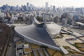 Yoyogi National Gymnasium, built for the 1964 Summer Olympics
 -
 Sunshine 60, at 239.7 m (786 ft), the tallest building in Asia until 1985, and in Japan until 1991
 -
 Landscape of Tokyo seen from top floors of Sumitomo Fudosan Roppongi Grand Tower
 -
 Minato City at night


.jpg)
Geography and government


The mainland portion of Tokyo lies northwest of Tokyo Bay and measures about 90 km (56 mi) east to west and 25 km (16 mi) north to south. The average elevation in Tokyo is 40 m (131 ft).[54] Chiba Prefecture borders it to the east, Yamanashi to the west, Kanagawa to the south, and Saitama to the north. Mainland Tokyo is further subdivided into the special wards (occupying the eastern half) and the Tama area (多摩地域) stretching westwards. Tokyo has a latitude of 35.65 (near the 36th parallel north), which makes it more southern than Rome (41.90), Madrid (40.41), New York City (40.71) and Beijing (39.91).[55]
Within the administrative boundaries of Tokyo Metropolis are two island chains in the Pacific Ocean directly south: the Izu Islands, and the Ogasawara Islands, which stretch more than 1,000 km (620 mi) away from the mainland. Because of these islands and the mountainous regions to the west, Tokyo's overall population density figures far under-represent the real figures for the urban and suburban regions of Tokyo.[56]
Under Japanese law, the prefecture of Tokyo is designated as a to (都), translated as metropolis.[57] Tokyo Prefecture is the most populous prefecture and the densest, with 6,100 inhabitants per square kilometer (16,000/sq mi); by geographic area it is the third-smallest, above only Osaka and Kagawa. Its administrative structure is similar to that of Japan's other prefectures. The 23 special wards (特別区, tokubetsu-ku), which until 1943 constituted the city of Tokyo, are self-governing municipalities, each having a mayor, a council, and the status of a city.
In addition to these 23 special wards, Tokyo also includes 26 more cities (市 -shi), five towns (町 -chō or machi), and eight villages (村 -son or -mura), each of which has a local government. The Tokyo Metropolitan Government administers the whole metropolis including the 23 special wards and the cities and towns that constitute the prefecture. It is headed by a publicly elected governor and metropolitan assembly. Its headquarters is in Shinjuku Ward.

Municipalities


Since 2001, Tokyo consists of 62 municipalities: 23 special wards, 26 cities, 5 towns and 8 villages. Any municipality of Japan has a directly elected mayor and a directly elected assembly, each elected on independent four-year cycles. 23 of Tokyo's municipalities cover the area that had been Tokyo City until WWII, 30 remain today in the Tama area (former North Tama, West Tama and South Tama districts), 9 on Tokyo's outlying islands.
- The special wards (特別区, tokubetsu-ku) of Tokyo comprise the area formerly incorporated as Tokyo City. The special wards use the word "city" in their official English name (e.g. Chiyoda City). The wards differ from other cities in having a unique administrative relationship with the prefectural government. Certain municipal functions, such as waterworks, sewerage, and fire-fighting, are handled by the Tokyo Metropolitan Government. To pay for the added administrative costs, the prefecture collects municipal taxes, which would usually be levied by the city.[58] The "three central wards" of Tokyo – Chiyoda, Chūō and Minato – are the business core of the city, with a daytime population more than seven times higher than their nighttime population.[59] Chiyoda Ward is unique in that it is in the very heart of the former Tokyo City, yet is one of the least populated wards. It is occupied by many major Japanese companies and is also the seat of the national government, and the Japanese emperor. It is often called the "political center" of the country.[60] Akihabara, known for being an otaku cultural center and a shopping district for computer goods, is also in Chiyoda.
- To the west of the special wards, Tokyo Metropolis consists of cities, towns, and villages that enjoy the same legal status as those elsewhere in Japan. While serving as "bed towns" for those working in central Tokyo, some of them also have a local commercial and industrial base, such as Tachikawa. Collectively, these are often known as the Tama area or Western Tokyo. The far west of the Tama area is occupied by the district (gun) of Nishi-Tama. Much of this area is mountainous and unsuitable for urbanization. The highest mountain in Tokyo, Mount Kumotori, is 2,017 m (6,617 ft) high; other mountains in Tokyo include Takanosu (1,737 m (5,699 ft)), Odake (1,266 m (4,154 ft)), and Mitake (929 m (3,048 ft)). Lake Okutama, on the Tama River near Yamanashi Prefecture, is Tokyo's largest lake. The district is composed of three towns (Hinode, Mizuho and Okutama) and one village (Hinohara). The Tokyo Metropolitan Government has designated Hachiōji, Tachikawa, Machida, Ōme and Tama New Town as regional centers of the Tama area,[61] as part of its plans to relocate urban functions away from central Tokyo.
- Tokyo has numerous outlying islands, which extend as far as 1,850 km (1,150 mi) from central Tokyo. Because of the islands' distance from the administrative headquarters of the Tokyo Metropolitan Government in Shinjuku, local subprefectural branch offices administer them. The Izu Islands are a group of volcanic islands and form part of the Fuji-Hakone-Izu National Park. The islands in order from closest to Tokyo are Izu Ōshima, Toshima, Nii-jima, Shikine-jima, Kōzu-shima, Miyake-jima, Mikurajima, Hachijō-jima, and Aogashima. The Izu Islands are grouped into three subprefectures. Izu Ōshima and Hachijojima are towns. The remaining islands are six villages, with Niijima and Shikinejima forming one village. The Ogasawara Islands include, from north to south, Chichi-jima, Nishinoshima, Haha-jima, Kita Iwo Jima, Iwo Jima, and Minami Iwo Jima. Ogasawara also administers two tiny outlying islands: Minami Torishima, the easternmost point in Japan and at 1,850 km (1,150 mi) the most distant island from central Tokyo, and Okinotorishima, the southernmost point in Japan.[62] Japan's claim on an exclusive economic zone (EEZ) surrounding Okinotorishima is contested by China and South Korea as they regard Okinotorishima as uninhabitable rocks which have no EEZ.[63] The Iwo chain and the outlying islands have no permanent population, but hosts Japan Self-Defense Forces personnel. Local populations are only found on Chichi-Jima and Haha-Jima. The islands form both Ogasawara Subprefecture and the village of Ogasawara, Tokyo.
| Flag, name w/o suffix | Full name | District or Subprefecture |
Population | LPE code (w/o checksum) | ||
|---|---|---|---|---|---|---|
| Japanese | Transcription | Translation | ||||
| 足立区 | Adachi-ku | Adachi Ward | — | 674,067 | 13121 | |
| 荒川区 | Arakawa-ku | Arakawa Ward | 213,648 | 13118 | ||
| 文京区 | Bunkyō-ku | Bunkyō Ward | 223,389 | 13105 | ||
| 千代田区 | Chiyoda-ku | Chiyoda Ward | 59,441 | 13101 | ||
| 中央区 | Chūō-ku | Chūō Ward (Central Ward) |
147,620 | 13102 | ||
| 江戸川区 | Edogawa-ku | Edogawa Ward (Edo River Ward) |
685,899 | 13123 | ||
| 板橋区 | Itabashi-ku | Itabashi Ward | 569,225 | 13119 | ||
| 葛飾区 | Katsushika-ku | Katsushika Ward (after Katsushika District) |
447,140 | 13122 | ||
| 北区 | Kita-ku | Kita Ward (North Ward) |
345,063 | 13117 | ||
| 江東区 | Kōtō-ku | Kōtō Ward | 502,579 | 13108 | ||
| 目黒区 | Meguro-ku | Meguro Ward | 280,283 | 13110 | ||
| 港区 | Minato-ku | Minato Ward (Harbor/Port District) |
248,071 | 13103 | ||
| 中野区 | Nakano-ku | Nakano Ward | 332,902 | 13114 | ||
| 練馬区 | Nerima-ku | Nerima Ward | 726,748 | 13120 | ||
| 大田区 | Ōta-ku | Ōta Ward | 722,608 | 13111 | ||
| 世田谷区 | Setagaya-ku | Setagaya Ward | 910,868 | 13112 | ||
| 渋谷区 | Shibuya-ku | Shibuya Ward | 227,850 | 13113 | ||
| 品川区 | Shinagawa-ku | Shinagawa Ward | 392,492 | 13109 | ||
| 新宿区 | Shinjuku-ku | Shinjuku Ward | 339,211 | 13104 | ||
| 杉並区 | Suginami-ku | Suginami Ward | 570,483 | 13115 | ||
| 墨田区 | Sumida-ku | Sumida Ward | 260,358 | 13107 | ||
| 台東区 | Taitō-ku | Taitō Ward | 200,486 | 13106 | ||
| 豊島区 | Toshima-ku | Toshima Ward (after Toshima District) |
294,673 | 13116 | ||
| あきる野市 | Akiruno-shi | Akiruno City | 80,464 | 13228 | ||
| 昭島市 | Akishima-shi | Akishima City | 111,449 | 13207 | ||
| 調布市 | Chōfu-shi | Chōfu City | 240,668 | 13208 | ||
| 府中市 | Fuchū-shi | Fuchū City (provincial capital city) |
260,891 | 13206 | ||
| 福生市 | Fussa-shi | Fussa City | 58,393 | 13218 | ||
| 八王子市 | Hachiōji-shi | Hachiōji City | 579,330 | 13201 | ||
| 羽村市 | Hamura-shi | Hamura City | 55,596 | 13227 | ||
| 東久留米市 | Higashi-Kurume-shi | Higashi-Kurume City East Kurume City (as opposed to Kurume City, Western Japan) |
116,869 | 13222 | ||
| 東村山市 | Higashi-Murayama-shi | Higashi-Murayama City East Murayama City (after Murayama Region) |
150,984 | 13213 | ||
| 東大和市 | Higashi-Yamato-shi | Higashi-Yamato City (here: Tokyo's Yamato City)[64] (as opposed to Kanagawa's Yamato City) |
85,229 | 13220 | ||