

A | B | C | D | E | F | G | H | CH | I | J | K | L | M | N | O | P | Q | R | S | T | U | V | W | X | Y | Z | 0 | 1 | 2 | 3 | 4 | 5 | 6 | 7 | 8 | 9
Highway 128 | ||||
|---|---|---|---|---|
| Ruta 128 | ||||
| Route information | ||||
| Maintained by Puerto Rico DTPW | ||||
| Length | 58.7 km[1] (36.5 mi) | |||
| Existed | 1953[2]–present | |||
| Major junctions | ||||
| South end | ||||
| North end | ||||
| Location | ||||
| Country | United States | |||
| Territory | Puerto Rico | |||
| Municipalities | Yauco, Maricao, Lares | |||
| Highway system | ||||
| ||||
| ||||

Puerto Rico Highway 128 (PR-128) is a road that travels from Yauco, Puerto Rico to Lares.[3] This highway extends from PR-2 in Yauco and ends at PR-111 near downtown Lares.[4][5]
Major intersections
-
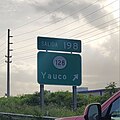 PR-2 west at exit 198 to PR-128 in Yauco
 -
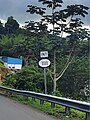 PR-128 north approaching PR-1111 in Lares
 -
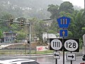 Signs for Puerto Rico Highways 111, 128 and 1111 in Lares


| Municipality | Location | km[1] | mi | Destinations | Notes |
|---|---|---|---|---|---|
| Yauco | Susúa Baja | 0.0 | 0.0 | Southern terminus of PR-128; PR-2 exit 198; diamond interchange | |
| 0.5– 0.6 | 0.31– 0.37 | ||||
| 1.4– 1.5 | 0.87– 0.93 | ||||
| Susúa Baja–Almácigo Bajo line | 1.8– 1.9 | 1.1– 1.2 | |||
| Almácigo Bajo | 2.2 | 1.4 | |||
| Almácigo Bajo–Diego Hernández line | 3.1– 3.2 | 1.9– 2.0 | |||
| 3.3– 3.4 | 2.1– 2.1 | ||||
| Naranjo | 12.8 | 8.0 | |||
| Rubias | 24.5 | 15.2 | |||
| Maricao | Indiera Alta | 25.7 | 16.0 | Southern terminus of the Ruta Panorámica concurrency; the Ruta Panorámica continues toward Sabana Grande | |
| 33.1 | 20.6 | ||||
| 33.1 | 20.6 | Puente de Río Prieto over the Río Prieto[6] | |||
| Lares | Bartolo | 36.8 | 22.9 | ||
| 37.9 | 23.5 | Northern terminus of the Ruta Panorámica concurrency | |||
| 40.6 | 25.2 | ||||
| La Torre | 44.3 | 27.5 | |||
| Río Blanco | 47.5 | 29.5 | Puente del Río Blanco[6] | ||
| La Torre–Mirasol– Buenos Aires tripoint | 52.6 | 32.7 | |||
| Buenos Aires–La Torre line | 54.6 | 33.9 | Former PR-431 | ||
| Lares barrio-pueblo | 58.7 | 36.5 | Northern terminus of PR-128 | ||
1.000 mi = 1.609 km; 1.000 km = 0.621 mi
| |||||
Related route
Highway 4128 | |
|---|---|
| Location | Lares |
| Length | 1.2 km[7] (0.75 mi) |
Puerto Rico Highway 4128 (PR-4128) is a bypass road that branches off from PR-128 and ends at PR-111 west of downtown Lares.[3] The entire route is located in Lares barrio-pueblo, Lares.
| km[7] | mi | Destinations | Notes | ||
|---|---|---|---|---|---|
| 1.2 | 0.75 | Western terminus of PR-4128 | |||
| 0.0 | 0.0 | Eastern terminus of PR-4128 | |||
| 1.000 mi = 1.609 km; 1.000 km = 0.621 mi | |||||
See also
References
- ^ a b Google (6 March 2020). "PR-128" (Map). Google Maps. Google. Retrieved 6 March 2020.
- ^ "Lares, Memoria Núm. 60" (PDF). Puerto Rico Planning Board (in Spanish). 1955. Retrieved 4 August 2020.
- ^ a b National Geographic Maps (2011). Puerto Rico (Map). 1:125,000. Adventure Map (Book 3107). Evergreen, Colorado: National Geographic Maps. ISBN 978-1566955188. OCLC 756511572.
- ^ "Tránsito Promedio Diario (AADT)". Puerto Rico Department of Transportation and Public Works (in Spanish). pp. 73–74. Archived from the original on 1 April 2019. Retrieved 31 May 2019.
- ^ "Map of Adjuntas at the Wayback Machine" (PDF). Archived from the original (PDF) on 17 April 2015. Retrieved 29 December 2018.
- ^ a b Luis F. Pumarada O’Neill (1991). "Los Puentes Históricos de Puerto Rico" (PDF) (in Spanish). Retrieved 10 March 2020.
- ^ a b Google (1 March 2020). "PR-4128" (Map). Google Maps. Google. Retrieved 1 March 2020.
External links
This Puerto Rico road-related article is a stub. You can help Wikipedia by expanding it. |
Text je dostupný za podmienok Creative Commons Attribution/Share-Alike License 3.0 Unported; prípadne za ďalších podmienok. Podrobnejšie informácie nájdete na stránke Podmienky použitia.
Antropológia
Aplikované vedy
Bibliometria
Dejiny vedy
Encyklopédie
Filozofia vedy
Forenzné vedy
Humanitné vedy
Knižničná veda
Kryogenika
Kryptológia
Kulturológia
Literárna veda
Medzidisciplinárne oblasti
Metódy kvantitatívnej analýzy
Metavedy
Metodika
Text je dostupný za podmienok Creative
Commons Attribution/Share-Alike License 3.0 Unported; prípadne za ďalších
podmienok.
Podrobnejšie informácie nájdete na stránke Podmienky
použitia.
www.astronomia.sk | www.biologia.sk | www.botanika.sk | www.dejiny.sk | www.economy.sk | www.elektrotechnika.sk | www.estetika.sk | www.farmakologia.sk | www.filozofia.sk | Fyzika | www.futurologia.sk | www.genetika.sk | www.chemia.sk | www.lingvistika.sk | www.politologia.sk | www.psychologia.sk | www.sexuologia.sk | www.sociologia.sk | www.veda.sk I www.zoologia.sk