

A | B | C | D | E | F | G | H | CH | I | J | K | L | M | N | O | P | Q | R | S | T | U | V | W | X | Y | Z | 0 | 1 | 2 | 3 | 4 | 5 | 6 | 7 | 8 | 9
Lake County, Indiana | |
|---|---|
 Former Lake County Courthouse in Crown Point, Indiana | |
 Seal | |
 Location in the state of Indiana | |
 Indiana's location in the U.S. | |
| Coordinates: 41°25′N 87°22′W / 41.417°N 87.367°W | |
| Country | |
| State | |
| Region | Northwest Indiana |
| Metro area | Chicago Metropolitan |
| Settled | October 1834[1] |
| Established | February 16, 1837[2] |
| Named for | Lake Michigan |
| County seat | Crown Point |
| Largest city | Hammond (population) Gary (total area) |
| Incorporated municipalities | 19 cities and towns
|
| Government | |
| • Type | County |
| • Body | Board of Commissioners |
| • Commissioner | Kyle W. Allen, Sr. (D, 1st) |
| • Commissioner | Jerry J. Tippy (R, 2nd) |
| • Commissioner | Michael C. Repay (D, 3rd) |
| • County Council | |
| Area | |
| • County | 626.5 sq mi (1,623 km2) |
| • Land | 498.9 sq mi (1,292 km2) |
| • Water | 127.6 sq mi (330 km2) |
| • Metro | 10,874 sq mi (28,160 km2) |
| • Rank | 12th largest county in Indiana |
| • Region | 2,726 sq mi (7,060 km2) |
| Dimensions | |
| • Length | 36 mi (58 km) |
| • Width | 16 mi (26 km) |
| Elevation [5] (mean) | 663 ft (202 m) |
| Highest elevation [6]—NE Winfield Twp | 801 ft (244 m) |
| Lowest elevation [7]—at Lake Michigan | 585 ft (178 m) |
| Population (2020) | |
| • County | 498,700 |
| • Estimate (2023) | 500,598 |
| • Rank | 2nd largest county in Indiana 131st largest county in U.S.[8] |
| • Density | 800/sq mi (310/km2) |
| • Metro | 9,522,434 |
| • Region | 819,537 |
| Time zone | UTC−6 (Central) |
| • Summer (DST) | UTC−5 (Central) |
| ZIP Codes | 46303, 46307–08, 46311–12, 46319–25, 46327, 46341–42, 46355–56, 46373, 46375–77, 46394, 46401–11 |
| Area code | 219 |
| Congressional district | 1st |
| Indiana Senate districts | 1st, 2nd, 3rd and 6th |
| Indiana House of Representatives districts | 1st, 2nd, 3rd, 11th, 12th, 14th, 15th and 19th |
| FIPS code | 18-089 |
| GNIS feature ID | 0450495 |
| Interstates | |
| U.S. Routes | |
| State Routes | |
| Airports | Gary/Chicago International Griffith-Merrillville |
| Waterways | Grand Calumet River Indiana Harbor and Ship Canal Kankakee River Lake Michigan |
| Amtrak stations | Dyer – Hammond-Whiting
|
| South Shore Line stations | Hammond – East Chicago Adam Benjamin Metro Center Gary/Chicago Airport – Miller |
| Public transit | East Chicago Transit Gary Public Transportation Broadway Metro Express |
| Website | www.lakecountyin.org |
| |
Lake County is a county located in the U.S. state of Indiana. In 2020, its population was 498,700,[9] making it Indiana's second-most populous county. The county seat is Crown Point.[10] The county is part of Northwest Indiana and the Chicago metropolitan area, and contains a mix of urban, suburban and rural areas. It is bordered on the north by Lake Michigan and contains a portion of the Indiana Dunes.[11][12] It includes Marktown, Clayton Mark's planned worker community in East Chicago.[13]
History
Early settlement
Originally inhabited by the Potawatomi and generations of indigenous ancestors, Lake County was established by European Americans on February 16, 1837.[2] From 1832 to 1836 the area that was to become Lake County was part of La Porte County.[14] From 1836 to 1837 it was part of Porter County.[14] It was named for its location on Lake Michigan.[15] The original county seat was Liverpool, but in 1840 Lake Court House, later renamed as Crown Point, was chosen.[16]
Lake County's population grew slowly before the 1850s. Construction of railroads to link Chicago to the rest of the country stimulated rapid development, and tens of thousands of settlers and immigrants bought land in the region. Small-scale industrialization began, but was primarily relegated to the northern coast of the county, where it could take advantage of the railroads along the coast and shipping on the Great Lakes. The 1900 Census gives a population of 37,892 residents.
Industrialization and immigration
Inland Steel Company established a plant in East Chicago in 1903 and U.S. Steel founded one in Gary in 1906; with industrial jobs the demand for labor associated with industrial jobs, the county's population exploded. Immigrants poured into the area from all over Central and Eastern Europe (there was also a smaller Mexican immigrant community). In addition, both black and white migrants came from many regions of the United States, particularly Appalachia and the South. Mostly rural blacks went north in the Great Migration, seeking both industrial jobs and escape from Jim Crow violence and disenfranchisement in the South.
By 1930, Lake County's population surpassed 260,000, with first- and second-generation Americans constituting a majority of the population. The second wave of the Ku Klux Klan gained a large following here in the 1920s, as it did for a time in the rest of Indiana. The KKK organized against the numerous European immigrants, who were mostly Catholic. While the steel industry reigned supreme, other industries also found the county to be an ideal location for cheap land and well-developed transportation networks, such as automobiles, oil, chemicals, consumer goods, food processing, and construction supply companies.[17]
The Great Depression was devastating to Lake County, as it was to other areas with economies based on heavy industry. The Depression, combined with industrial strife, changing demographics, and unionization, caused a realignment of politics in Lake County. It became a stronghold of the Democratic Party; Lake County has supported the Democratic nominee for president in every election since 1932 (exceptions occurred in 1956 and 1972). Indiana's 1st congressional district has elected Democratic candidates in every election since 1930.
World War II restored prosperity, as industry revived to support the war effort. Good economic times continued into the 1970s. During this period, unions helped industrial workers gain middle-class wages. In addition to attracting refugees and immigrants from Europe, black Americans and Mexicans migrated here in the postwar period in even higher numbers than in the 1910-1930 period. As minority populations exploded in such industrial cities as East Chicago and Gary, racial tensions surfaced again. Following construction of state and federal highways, development of cheaper land provided newer housing to middle-class people who could afford it. Both whites and established black families moved out of the aging industrial cities.[17]
Recent history
Lake County's population peaked at 546,000 in 1970. Severe industrial decline took place during the 1973-1991 period, brought on by foreign competition, new management philosophies that called for major workforce reductions, and productivity gains from technology. The decline was particularly intense in the steel industry: steel employment exceeded 60,000 in the 1960s, and declined progressively to just 18,000 by 2015. Lake County's population declined 13% to bottom out at 475,000 in 1990.
The industrial decline of the 1980s cast a long shadow over Lake County: the county did not regain the level of employment it had in 1980 until 1996, after which the employment level roughly flatlined. The county's economic output peaked in 1978, and has not since recovered, remaining 15-20% below the peak after adjusting for inflation. As prosperity declined, so did the immigration that powered the county's explosive population growth before 1950: per the 2000 census, only 5.3% of Lake County's residents were foreign-born, compared to over 11% for the United States as a whole.[18]
The population recovered somewhat during the 1990s and 2000s, as the local economy adjusted. Suburban growth has also been driven by commuter populations of workers who are employed in Chicago and commute via expressways or the South Shore Line. In 2007, it was estimated that 44,000 workers commuted from Lake County, Indiana, to Chicago for work.[18] The decline of industrial cities and growth of suburbs has been so sharp, that by 1990 a majority of the county's population lived outside of the four traditional industrial cities. Lake County still continues to struggle with urban decline and poverty, suburban sprawl and traffic jams, and a stagnating population.[17]
Geography
According to the 2010 census, the county has a total area of 626.56 square miles (1,622.8 km2), of which 498.96 square miles (1,292.3 km2) (or 79.63%) is land and 127.60 square miles (330.5 km2) (or 20.37%) is water.[19]
The northern and southern portions of the county (north of U.S. 30 and south of Lowell) are mainly low and flat, except for a few sand ridges and dunes and were both once very marshy and had to be drained. The lowest point, at 585 feet (178 m),[7] is along the Lake Michigan shoreline.
The central part of the county is higher and hillier. As you travel south from the low and relatively flat lake plain in the northern part of the county, the land gradually rises in elevation until the peak of the Valparaiso Moraine. The highest point, at 801 feet (244 m),[6] is in northeastern Winfield Township near 109th Street and North Lakeshore Drive in Lakes of the Four Seasons. From here the land descends south into the Kankakee Outwash Plain until the Kankakee River is reached.
The geographic center of Lake County is approximately 200 feet (60 m) northwest of Burr Street and West 113th Avenue in Center Township 41°24′53.8″N 87°24′14.3″W / 41.414944°N 87.403972°W.
National protected area
- Indiana Dunes National Park – also in LaPorte and Porter counties
Transit
Airports
Major highways
Interstate 65 in Lake County is called the Casimir Pulaski Memorial Highway. Interstate 80/94/US 6 is the Frank Borman Expressway from the Illinois state line east to the Indiana Toll Road interchange in the eastern portion of the county. Interstate 94 has been referred to as the Chicago-Detroit Industrial Freeway. US 6 is part of the Grand Army of the Republic Highway. Broadway (Indiana 53) is also the Carolyn Mosby Memorial Highway. Indiana 51 is known for its entire length as the Adam Benjamin Memorial Highway. US 30 is part of the historic Lincoln Highway. US 12 from Gary eastward is part of Dunes Highway. Cline Avenue (Indiana 912) from US 12 north and westward is known as the Highway Construction Workers Memorial Highway.
Railroads
- Amtrak
- Canadian National Railway
- Chicago, Fort Wayne and Eastern Railroad
- Chicago South Shore and South Bend Railroad
- CSX Transportation
- Gary Railway
- Indiana Harbor Belt Railroad
- Norfolk Southern Railway
- South Shore Line
Adjacent counties
- Cook County, Illinois (northwest)
- Will County, Illinois (west)
- Kankakee County, Illinois (southwest)
- Porter County (east)
- Jasper County (southeast)
- Newton County (south)
Municipalities
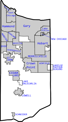
The municipalities in Lake County, and their populations as of the 2020 Census, are:
Cities
- Crown Point – 33,899
- East Chicago – 26,370
- Gary – 69,093
- Hammond – 77,879
- Hobart – 29,752
- Lake Station – 13,235
- Whiting – 4,559
Towns
- Cedar Lake – 14,106
- Dyer – 16,517
- Griffith – 16,528
- Highland – 23,984
- Lowell – 10,680
- Merrillville – 36,444
- Munster – 23,894
- New Chicago – 1,999
- Schererville – 29,646
- Schneider – 269
- St. John – 20,303
- Winfield – 7,181
Census-designated places
- Lake Dalecarlia – 1,332
- Lakes of the Four Seasons – 3,936
(7,091 including portion in Porter County) - Shelby – 453
Unincorporated communities
Townships
The 11 townships of Lake County, with their populations as of the 2020 Census, are:
- Calumet – 91,970
- Cedar Creek – 12,725
- Center – 38,630
- Eagle Creek – 1,719
- Hanover – 18,214
- Hobart – 40,652
- North – 156,686
- Ross – 48,529
- St. John – 68,972
- West Creek – 7,676
- Winfield – 12,927
Economy
Despite the decline of heavy industry, manufacturing was still the largest employment sector in Lake County in 2010 with over 45,000 workers employed, followed closely by healthcare and social assistance at 44,000 workers, public administration at 40,000 workers, retail trade at 37,000 workers, accommodation and food services at 25,000 workers, and construction at 15,000 workers.[18]
Lake County's GDP in 2010 was measured at nearly $25 billion. Manufacturing was also the largest sector of the economy in economic terms, contributing over $5.8 billion to the county's GDP in 2010. It was followed by healthcare and social assistance at $2.6 billion, public administration at $2.5 billion, and retail trade at $1.9 billion. While Lake County's average income was approximately 24% higher than the national average in 1978, in 2010 Lake County had fallen significantly behind the United States as a whole, with average income being approximately 12.9% lower. The national average surpassed Lake County sometime around 1986.
Businesses with the largest number of employees in the county are: [20]
- Americall Group, Inc. – Hobart
- Ameristar Casino – East Chicago
- BP Whiting Refinery – Whiting
- Canadian National Railway – Whiting
- Cargill – Hammond
- Cleveland-Cliffs Indiana Harbor Works – East Chicago
- Community Hospital – Munster
- Franciscan Alliance, Inc. – locations throughout the region
- Franciscan Health Hammond – Hammond (closed)
- Hard Rock Casino Northern Indiana – Gary
- Horseshoe Casino – Hammond
- Majestic Star Casino – Gary (closed)
- Methodist Hospitals Northlake Campus – Merrillville
- NiSource – Merrillville
- Radisson Hotel at Star Plaza – Merrillville (closed)
- St. Catherine Hospital – East Chicago
- St. Mary Medical Center – Hobart
- Times Media Company – Munster
- Unilever – Whiting
- U.S. Steel Gary Works – Gary
Education
Public school districts
The administration of public schools in Lake County is divided among 16 corporations and governing bodies,[21] more than any other Indiana county.[22]
- Crown Point Community School Corporation – Center and Winfield townships
- Gary Community School Corporation – City of Gary
- Griffith Public Schools – Town of Griffith
- Hanover Community School Corporation – Hanover Township
- Lake Central School Corporation – St. John Township
- Lake Ridge Schools Corporation – unincorporated Calumet Township
- Lake Station Community Schools – City of Lake Station
- Merrillville Community School Corporation – Ross Township
- River Forest Community School Corporation – Town of New Chicago and some portions of adjacent communities
- School City of East Chicago – City of East Chicago
- School City of Hammond – City of Hammond
- School City of Hobart – City of Hobart within Hobart Township
- School City of Whiting – City of Whiting
- School Town of Highland – Town of Highland
- School Town of Munster – Town of Munster
- Tri-Creek School Corporation – Cedar Creek, Eagle Creek and West Creek townships
Private schools
Elementary and secondary schools operated by the Diocese of Gary:
- Andrean High School, Merrillville (9–12)
- Aquinas School at St. Andrew's, Merrillville (PK–8)
- Bishop Noll Institute, Hammond (9–12)
- Our Lady of Grace, Highland (PK–8)
- St. Casimir, Hammond (PK–8)
- St. John Bosco, Hammond (PK–8)
- St. John the Baptist, Whiting (PK–8)
- St. John the Evangelist, St. John (PK–8)
- St. Mary, Crown Point (PK–8)
- St. Mary, Griffith (PK–8)
- St. Michael, Schererville (PK–8)
- St. Stanislaus, East Chicago (PK–8)
- St. Thomas More, Munster (PK–8)
Other parochial and private schools:
- St. Paul's Lutheran School, Munster (PK–8)
- Trinity Lutheran School, Crown Point (PK–8)
- Trinity Lutheran School, Hobart (PK–8)
Colleges and universities
Public libraries
The county is served by seven different public library systems:
- Crown Point Community Library has its main location with a branch in Winfield.[24]
- East Chicago Public Library has its main location and the Robart A. Pastrick branch.[25]
- Gary Public Library has its main location, the Du Bois Library, as well as the Brunswick, Kennedy and Woodson branches.[26]
- Hammond Public Library[27]
- Lake County Public Library has its main location in Merrillville as well as Cedar Lake, Dyer-Schererville, Griffith-Calumet Township, Highland, Hobart, Lake Station-New Chicago, Munster and St. John branches.[28]
- Lowell Public Library has its main location with branches in Schneider and Shelby.[29]
- Whiting Public Library[30]
Hospitals
- Community Hospital, Munster – 454 beds[31]
- Franciscan Health Crown Point, Crown Point – 203 beds (Level III Trauma Center)[31][32][33]
- Franciscan Health Dyer, Dyer – 223 beds[31][32]
- Franciscan Health Munster, Munster – 63 beds[31][32]
- Methodist Hospitals – 536 beds[31]
- Northlake Campus, Gary
- Southlake Campus, Merrillville
- NW Indiana ER and Hospital, Hammond – 6 beds[31]
- St. Catherine Hospital, East Chicago – 216 beds[31]
- St. Mary Medical Center, Hobart – 215 beds[31]
- UChicago Medicine Crown Point, Crown Point – 8 beds (opening April 2024)[34]
Mediaedit
The Times, based in Munster, is the largest daily newspaper in Lake County and Northwest Indiana and the second largest in the state. Lake County is also served by the Post-Tribune, a daily newspaper based in Merrillville.
Lakeshore Public Television operates WYIN-TV Gary on channel 56 and is the local PBS station in the Chicago television market.
These eight broadcast radio stations serve Lake County and are part of the Chicago market:
Climate and weatheredit
| Climate data for Lowell, Indiana (1981-2010 normals, extremes 1963-present) | |||||||||||||
|---|---|---|---|---|---|---|---|---|---|---|---|---|---|
| Month | Jan | Feb | Mar | Apr | May | Jun | Jul | Aug | Sep | Oct | Nov | Dec | Year |
| Record high °F (°C) | 66 (19) |
73 (23) |
85 (29) |
91 (33) |
95 (35) |
104 (40) |
101 (38) |
104 (40) |
98 (37) |
92 (33) |
77 (25) |
70 (21) |
104 (40) |
| Mean daily maximum °F (°C) | 31.2 (−0.4) |
35.8 (2.1) |
Zdroj:https://en.wikipedia.org?pojem=Lake_County,_Indiana|||||||||||