

A | B | C | D | E | F | G | H | CH | I | J | K | L | M | N | O | P | Q | R | S | T | U | V | W | X | Y | Z | 0 | 1 | 2 | 3 | 4 | 5 | 6 | 7 | 8 | 9
Jacksonville | |
|---|---|
| City of Jacksonville and Duval County | |
 Seal | |
| Nickname(s): | |
| Motto(s): Where Florida Begins, It's Easier Here | |
 Location within Duval County | |
 Jacksonville Location within Florida  Jacksonville Location within the United States | |
| Coordinates: 30°20′13″N 81°39′41″W / 30.33694°N 81.66139°W[3] | |
| Country | United States |
| State | Florida |
| County | Duval |
| Founded | June 15, 1822 |
| Incorporated | February 9, 1832 |
| Consolidated[4] | October 1, 1968 |
| Named for | Andrew Jackson |
| Government | |
| • Type | Strong Mayor–Council |
| • Body | Jacksonville City Council |
| • Mayor | Donna Deegan (D) |
| • City Council | Members
|
| Area | |
| • Total | 874.46 sq mi (2,264.84 km2) |
| • Land | 747.30 sq mi (1,935.49 km2) |
| • Water | 127.16 sq mi (329.35 km2) |
| Elevation | 16 ft (5 m) |
| Population (2020) | |
| • Total | 949,611 |
| • Estimate (July 2022)[6] | 971,319 |
| • Rank | 31st in North America 11th in the United States 1st in Florida |
| • Density | 1,270.73/sq mi (490.63/km2) |
| • Urban | 1,247,374 (US: 40th) |
| • Urban density | 2,175.9/sq mi (840.1/km2) |
| • Metro | 1,733,937 (US: 39th) |
| Demonym(s) | Jaxon, Jacksonvillian |
| Time zone | UTC−5 (Eastern (EST)) |
| • Summer (DST) | UTC−4 (EDT) |
| ZIP Codes | 32099, 32201–32212, 32214–32241, 32244–32247, 32250, 32254–32260, 32266, 32267, 32277, 32290 |
| Area code(s) | 904, 324 |
| FIPS code | 12-35000 |
| GNIS feature ID | 0295003[8] |
| Website | City of Jacksonville |


.jpg)
.jpg)
.jpg)


Jacksonville is the most populous city proper in the U.S. state of Florida, located on the Atlantic coast of northeastern Florida. It is the seat of Duval County,[9] with which the City of Jacksonville consolidated in 1968. It is the largest city by area in the contiguous United States as of 2020.[10]
City-county consolidation greatly increased Jacksonville's official population and extended its boundaries, placing most of Duval County's population within the new municipal limits; Jacksonville grew to 900 square miles (2,300 km2).[11]
As of July 2022, Jacksonville's population was 971,319, while the population of Duval County was about 1 million.[11][12] After consolidation, Jacksonville became the most populous city in Florida and the Southeastern United States, and the largest in the South outside the state of Texas.[13] With a population of 1,733,937, the Jacksonville metropolitan area ranks as Florida's fourth-largest metropolitan region.[7] The metropolitan area consists of Clay County, St. Johns County, Nassau County, and Baker County.
Jacksonville straddles the St. Johns River in the First Coast region of northeastern Florida, about 12 miles (19 kilometers) south of the Georgia state line (25 mi or 40 km to the urban core/downtown) and 350 miles (560 km) north of Miami.[14] The Jacksonville Beaches communities are along the adjacent Atlantic coast. The area was originally inhabited by the Timucua people, and in 1564 was the site of the French colony of Fort Caroline, one of the earliest European settlements in what is now the continental United States. Under British rule, a settlement grew at the narrow point in the river where cattle crossed, known as Wacca Pilatka to the Seminole and the Cow Ford to the British. A platted town was established there in 1822, a year after the United States gained Florida from Spain; it was named after Andrew Jackson, the first military governor of the Florida Territory and seventh President of the United States.
Harbor improvements since the late 19th century have made Jacksonville a major military and civilian deep-water port. Its riverine location facilitates Naval Station Mayport, Naval Air Station Jacksonville, the U.S. Marine Corps Blount Island Command, and the Port of Jacksonville, Florida's largest seaport by volume.[15] Jacksonville's military bases and the nearby Naval Submarine Base Kings Bay form the third largest military presence in the United States.[16] Significant factors in the local economy include services such as banking, insurance, healthcare and logistics. As with much of Florida, tourism is important to the Jacksonville area, particularly tourism related to golf with the PGA Tour headquarters located in nearby Ponte Vedra Beach.[17][18] People from Jacksonville are known as Jacksonvillians and, informally, as Jaxsons or Jaxons (both derived from Jax, the shortened nickname for the city).[19][20][21][22][23]
History
Early history

The area of the modern city of Jacksonville has been inhabited for thousands of years. On Black Hammock Island in the national Timucuan Ecological and Historic Preserve, a University of North Florida team discovered some of the oldest remnants of pottery in the United States, dating to 2500 BCE.[24]
In the 16th century, the beginning of the historical era, the region was inhabited by the Mocama, a coastal subgroup of the Timucua people. At the time of contact with Europeans, all Mocama villages in present-day Jacksonville were part of the powerful chiefdom known as the Saturiwa, centered around the mouth of the St. Johns River.[25] One early French map shows a village called Ossachite at the site of what is now downtown Jacksonville; this may be the earliest recorded name for that area.[26]
In 1562, French Huguenot explorer Jean Ribault charted the St. Johns River, calling it the River of May because that was the month of his discovery. Ribault erected a stone column at his landing site near the river's mouth, claiming the newly discovered land for France.[27] In 1564, René Goulaine de Laudonnière established the first European settlement on the St. Johns River, Fort Caroline, near the main village of the Saturiwa.
Philip II of Spain ordered Pedro Menéndez de Avilés to protect the interests of Spain by attacking the French at Fort Caroline. On September 20, 1565, a Spanish force from the nearby Spanish settlement of St. Augustine attacked Fort Caroline, and killed nearly all the French soldiers defending it.[28] The Spanish renamed the fort as San Mateo and, following the expulsion of the French, St. Augustine became the most important European settlement in Florida. The location of Fort Caroline is subject to debate, but a reconstruction of the fort was established in 1964 along the St. Johns River.[29]

Spain ceded Florida to the British in 1763 as part of the Treaty of Paris in the aftermath of the Seven Years' War (known as the French and Indian War on the North American front). The British soon constructed the King's Road connecting St. Augustine to Georgia. The road crossed the St. Johns River at a narrow point, which the Seminole called Wacca Pilatka and the British called the Cow Ford; these names reflected the use of the ford for moving cattle across the river there.[30][31][32]
The British introduced the cultivation of sugarcane, indigo, and fruits as cash crops on plantations, in addition to exporting lumber. A large number of British colonists who were "energetic and of good character" were given land grants in the region and emigrated to the region, becoming the first English-speaking population in Florida. These colonists came from England, Georgia, South Carolina and Bermuda. British judges introduced the system of common law to Florida, resulting in the Floridian legal system utilizing concepts such as trial-by-jury, habeas corpus and county-based government.[33][34]
After their defeat in the American Revolutionary War, Britain returned control of the territory to Spain in 1783 via the Peace of Paris. The settlement at the Cow Ford continued to grow.[citation needed]
Founding and 19th century

After Spain ceded the Florida Territory to the United States in 1821, American settlers on the north side of the Cow Ford decided to plan a town, laying out the streets and plats. They named the town Jacksonville, after celebrated war hero and first Territorial Governor (later U.S. president) Andrew Jackson. Led by Isaiah D. Hart, residents wrote a charter for a town government, which the Florida Legislative Council approved on February 9, 1832.
During the American Civil War, Duval County produced several units that fought for the Confederate States Army. At least two were raised out of Jacksonville: the Jacksonville Light Infantry, a militia unit formed in 1859, and the Duval County Cow Boys, mustered in during the summer of 1861. Both units fought as part of the 3rd Florida Infantry.[35] The St. John's Greys, the Milton Artillery, and Company H of 1st Florida Cavalry Regiment were also all formed by men from Jacksonville.[36]
Jacksonville was also a key supply point for hogs and cattle shipped from Florida to feed the Confederate forces. The city was blockaded by Union forces, who gained control of nearby Fort Clinch. Though no battles were fought in Jacksonville proper, the city changed hands several times between Union and Confederate forces. In the Skirmish of the Brick Church in 1862, Confederates won their first victory in the state.[37] However, Union forces captured a Confederate position at the Battle of St. Johns Bluff, and occupied Jacksonville in 1862. Slaves escaped to freedom in Union lines. In February 1864 Union forces left Jacksonville and confronted a Confederate Army at the Battle of Olustee, going down to defeat.
Union forces retreated to Jacksonville and held the city for the remainder of the war. In March 1864 a Confederate cavalry confronted a Union expedition in the Battle of Cedar Creek. Warfare and the long occupation left the city disrupted after the war.[38]
During Reconstruction and the Gilded Age, Jacksonville and nearby St. Augustine became popular winter resorts for the rich and famous. Visitors arrived by steamboat and later by railroad. President Grover Cleveland attended the Sub-Tropical Exposition in the city on February 22, 1888, during his trip to Florida.[39] This highlighted the visibility of the state as a worthy place for tourism. The city's tourism, however, was dealt major blows in the late 19th century by yellow fever outbreaks. Extending the Florida East Coast Railway further south drew visitors to other areas. From 1893 to 1938, Jacksonville was the site of the Florida Old Confederate Soldiers and Sailors Home; it operated a nearby cemetery.[40]
20th and 21st centuries
1900 to 1939

On May 3, 1901, downtown Jacksonville was ravaged by a fire that started as a kitchen fire. Spanish moss at a nearby mattress factory was quickly engulfed in flames and enabled the fire to spread rapidly. In a mere eight hours, it swept through 146 city blocks, destroyed over 2,000 buildings, left about 10,000 homeless and killed seven residents. The Confederate Monument in Hemming Park was one of the few landmarks to survive the fire. Governor William Sherman Jennings declared martial law and sent the state militia to maintain order; on May 17, municipal authority resumed.[41] It is said the glow from the flames could be seen in Savannah, Georgia, and the smoke plumes seen in Raleigh, North Carolina. Known as the "Great Fire of 1901", it was one of the worst disasters in Florida history and the largest urban fire in the southeastern United States. Architect Henry John Klutho was a primary figure in the reconstruction of the city.[42] The first multi-story structure built by Klutho was the Dyal-Upchurch Building in 1902.[43][44] The St. James Building, built on the previous site of the St. James Hotel that burned down, was built in 1912 as Klutho's crowning achievement.[45][46]
In the 1910s, northern film studios headquartered in New York City, Philadelphia, and Chicago were attracted to Jacksonville's warm climate, exotic landscapes, excellent rail access, and cheap labor. More than 30 silent film studios were established over the decade, earning Jacksonville the title of "Winter Film Capital of the World". However, the emergence of Hollywood as a major film production center ended the city's film industry. One movie studio site, Norman Studios, remains in Arlington; it has been converted to the Jacksonville Silent Film Museum at Norman Studios.[47]

During this time, Jacksonville also became a banking and insurance center, with companies such as Barnett Bank, Atlantic National Bank, Florida National Bank, Prudential, Gulf Life, Afro-American Insurance, Independent Life and American Heritage Life thriving in the business district. The Walker Business College was opened c. 1916 in Jacksonville and advertised that it was the largest African American business school in the United States.[48]
1940 to 1979

During World War II, The U.S. Navy became a major employer and economic force, constructing three Navy bases in the city, while the U.S. Marine Corps established Blount Island Command.
Jacksonville, like most large cities in the United States, suffered from many negative effects of rapid urban sprawl after World War II. The construction of federal highways essentially subsidized development of suburban housing, and wealthier, better established residents moved to newer housing in the suburbs. After World War II, the government of the city of Jacksonville began to increase spending to fund new public building projects in the postwar economic boom. Mayor W. Haydon Burns' Jacksonville Story resulted in the construction of a new city hall, civic auditorium, public library and other projects that created a sense of civic pride. Development of suburbs led to a growing middle class who lived outside the urban core. An increasing proportion of residents in Jacksonville's urban core had a higher than average rate of poverty, especially as businesses and jobs also migrated to the suburbs.[49]
Given the postwar migration of residents, businesses, and jobs, the city's tax base declined. It had difficulty funding education, sanitation, and traffic control within the city limits. In addition, residents in unincorporated suburbs had difficulty obtaining municipal services, such as sewage and building code enforcement. In 1958, a study recommended the city of Jacksonville begin annexing outlying communities to create the needed larger geographic tax base to improve services throughout the county. Voters outside the city limits rejected annexation plans in six referendums between 1960 and 1965.
On August 27, 1960, a white mob attacked civil rights demonstrators in Hemming Park with clubs. The police largely stood by.
In 1962, a federal court ordered the city to prepare a plan for integration of public schools, in accordance with the ruling of the Supreme Court in Brown v. Board of Education (1954). A study found schools were in poor condition and poorly equipped.
On December 29, 1963, the Hotel Roosevelt fire killed 22 people, the highest one-day death toll in Jacksonville.[50] On September 10, 1964, Hurricane Dora made landfall near St. Augustine, causing major damage to buildings in North Florida. Hurricane Dora was the first recorded hurricane to make a direct hit to North Florida.[51]
In the mid-1960s, corruption scandals arose among city and some county officials, who were mainly part of a traditional white Democratic network that had dominated politics for the decades since the disenfranchisement of most African Americans at the turn of the 20th century which effectively hollowed out the Republican Party. After a grand jury was convened to investigate, 11 officials were indicted and more were forced to resign.

In 1963 the Southern Association of Colleges and Schools threatened to withdraw accreditation of area schools in a year because of "instructional deficiencies". But voters refused to approve new taxes to improve school conditions. In late 1963, Duval County was spending $299 per student compared to the state average spending of $372 per student. In 1964 all 15 of Duval County's public high schools lost their accreditation.[52] This added momentum to proposals for government reform.
Jacksonville Consolidation, led by J. J. Daniel and Claude Yates, began to win more support during this period, from both inner-city blacks, who wanted more involvement in government after passage of the Voting Rights Act of 1965, that provided federal oversight and enforcement of their right to vote, and whites in the suburbs, who wanted more services and more control over the central city. Lower taxes, increased economic development, unification of the community, better public spending, and effective administration by a more central authority were all cited as reasons for a new consolidated government.
When a consolidation referendum was held in 1967, voters approved the plan with a 65 percent approval. On October 1, 1968, the city and county governments merged to create the Consolidated City of Jacksonville. Fire, police, health & welfare, recreation, public works, and housing & urban development were all combined under the new government. In honor of the occasion, then-Mayor Hans Tanzler posed with actress Lee Meredith behind a sign marking the new border of the "Bold New City of the South" at Florida 13 and Julington Creek.[53] The consolidation created a 900-square-mile entity.
1980 to present

Tommy Hazouri supported passage of environmental regulations and reduced pollution odor during his single term as mayor, which began in 1987.[54]
Ed Austin was elected as mayor in 1991. His most lasting contribution is the River City Renaissance program, a $235 million bond issued in 1993 by the city of Jacksonville which funded urban renewal and revamped the city's historic downtown neighborhoods. Austin oversaw the city's purchase and refurbishing of the St. James Building, which is now used as Jacksonville's city hall. He was mayor in 1993 when Jacksonville was awarded its National Football League franchise, the Jacksonville Jaguars.[55][56] They are the only major sports franchise in the city, making Jacksonville one of only two markets (the other one being Green Bay), and the only major city, to have a single sports franchise, and for that franchise to be an NFL team.
The Better Jacksonville Plan, promoted as a "blueprint for Jacksonville's future" and approved by Jacksonville voters in 2000, authorized a half-penny sales tax. This generated most of the revenue required for the $2.25 billion package of major projects, which have included road and infrastructure improvements, environmental preservation, targeted economic development, and new or improved public facilities.[57]
In 2005, Jacksonville hosted Super Bowl XXXIX, which was seen by an estimated 86 million viewers.[58]
The city has suffered damage in natural disasters. In October 2016, Hurricane Matthew caused major flooding and damage to Jacksonville, Jacksonville Beach, Atlantic Beach and Neptune Beach, the first such damage in the area since 2004.[59] In September 2017, Hurricane Irma caused record-breaking floods in Jacksonville, with a severity not seen since 1846.[60][61]
As has been typical of other metropolitan areas across the country, suburban growth has continued around Jacksonville, where large areas of land were available for development, drawing more residents, businesses and jobs from the city. This has resulted in further demographic changes. The city's largest ethnic group, non-Hispanic white,[49] declined from 75.8% of the population in 1970 to 55.1% by 2010.[62]
Geography
Cityscape

Topography
According to the United States Census Bureau, the city has a total area of 874.3 square miles (2,264 km2), making Jacksonville the largest city in land area in the contiguous United States; of this, 86.66% (757.7 sq mi or 1,962 km2) is land and 13.34% (116.7 sq mi or 302 km2) is water. Jacksonville completely surrounds the town of Baldwin. Nassau County lies to the north, Baker County lies to the west, and Clay and St. Johns counties lie to the south. Jacksonville has a coast on the Atlantic Ocean with the Jacksonville Beaches. The city developed along both sides of the St. Johns River. The Trout River, a major tributary of the St. Johns River, is entirely within Jacksonville.
Soil composition is primarily sand and clay rather than limestone, so few sinkholes develop; however, deep, large diameter sinkholes do occur.[63]
Architecture
The architecture of Jacksonville varies in style. Few structures in the city center predate the Great Fire of 1901.[64] The city is home to one of the largest collections of Prairie School style buildings outside the Midwest.[65] Following the Great Fire of 1901, Henry John Klutho came to influence generations of local designers with his works by both the Chicago School, championed by Louis Sullivan, and the Prairie School of architecture, popularized by Frank Lloyd Wright. Jacksonville is also home to a notable collection of Mid-Century modern architecture.[66] Local architects Robert C. Broward, Taylor Hardwick, and William Morgan adapted a range of design principles, including International style, Brutalism, Futurism and Organicism, all applied with an American interpretation generally referred to today as Mid-century modern design.[66] The architecture firms of Reynolds, Smith & Hills (RS&H)[67] and Kemp, Bunch & Jackson (KBJ) have also contributed a number of important works to the city's modern architectural movement.
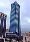
Jacksonville's early predominant position as a regional center of business left an indelible mark on the city's skyline. Many of the earliest skyscrapers in the state were constructed in Jacksonville, dating to 1902.[68] The city last held the state height record from 1974 to 1981.[69] The tallest building in Downtown Jacksonville's skyline is the Bank of America Tower, constructed in 1990 as the Barnett Center. It has a height of 617 ft (188 m) and includes 42 floors.[70][71] Other notable structures include the 37-story Wells Fargo Center (with its distinctive flared base making it the defining building in the Jacksonville skyline),[72][73] originally built in 1972–1974 by the Independent Life and Accident Insurance Company, and the 28-floor Riverplace Tower. When this tower was completed in 1967, it was the tallest precast, post-tensioned concrete structure in the world.[74][75]
-
 Laura Street Trio (1902–1912)
 -
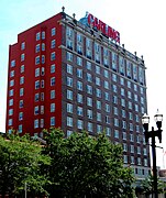 The Carling (1925)
 -
 11 East Forsyth (1926)
 -
 Eight Forty One (1955)
 -
 Riverplace Tower (1967)
 -
 Wells Fargo Center (1974)
 -
 TIAA Bank Center (1983)
 -
 Bank of America Tower (1990)


Neighborhoods
There are more than 500 neighborhoods within Jacksonville's vast area.[76] These include Downtown Jacksonville and its surrounding neighborhoods, including LaVilla, Brooklyn, Riverside and Avondale, Springfield, Eastside, Mandarin, and San Marco.[77] Additionally, greater Jacksonville is traditionally divided into several amorphous areas, comprising large parts of Duval County. These are Northside, Westside, Southside, and Arlington, as well as the Jacksonville Beaches.[78]
Four municipalities have retained their own governments since consolidation; these are Baldwin and the three Jacksonville Beaches towns of Atlantic Beach, Neptune Beach, and Jacksonville Beach.[79] Four of Jacksonville's neighborhoods, Avondale, Ortega, Springfield, and Riverside, have been identified as U.S. historic districts and are in the National Register of Historic Places.[80]


