

A | B | C | D | E | F | G | H | CH | I | J | K | L | M | N | O | P | Q | R | S | T | U | V | W | X | Y | Z | 0 | 1 | 2 | 3 | 4 | 5 | 6 | 7 | 8 | 9
.svg) | |
| Area | 523,780 km2 (202,230 sq mi)[1] |
|---|---|
| Population | 52,700,000 (2023)[1] |
| Population density | 100.6/km2 (260.6/sq mi) (2023) |
| GDP (PPP) | $738.8 billion (2023) |
| GDP (nominal) | $362.62 billion (exchange rate) (2023) |
| GDP per capita | $6,880 (exchange rate) (2023) $14,019 (PPP) (2023) |
| Demonym | Central American[a] |
| Countries | |
| Dependencies | |
| Languages | |
| Time zones | UTC−06:00 to UTC−05:00 |
| Largest cities | |
| UN M49 code | 013 – Central America419 – Latin America and the Caribbean019 – Americas001 – World |
| Part of a series on |
| Central America |
|---|
 |
Central America[b] is a subregion of North America.[2] Its political boundaries are defined as bordering Mexico to the north, Colombia to the south, the Caribbean Sea to the east, and the Pacific Ocean to the west. Central America is usually defined as consisting of seven countries: Belize, Costa Rica, El Salvador, Guatemala, Honduras, Nicaragua, and Panama. Within Central America is the Mesoamerican biodiversity hotspot, which extends from northern Guatemala to central Panama. Due to the presence of several active geologic faults and the Central America Volcanic Arc, there is a high amount of seismic activity in the region, such as volcanic eruptions and earthquakes, which has resulted in death, injury, and property damage.
In the pre-Columbian era, Central America was inhabited by the Indigenous peoples of Mesoamerica to the north and west and the Isthmo-Colombian peoples to the south and east. Following the Spanish expedition of Christopher Columbus' voyages to the Americas, Spain began to colonize the Americas. From 1609 to 1821, the majority of Central American territories (except for what would become Belize and Panama, and including the modern Mexican state of Chiapas) were governed by the viceroyalty of New Spain from Mexico City as the Captaincy General of Guatemala. On 24 August 1821, Spanish Viceroy Juan de O'Donojú signed the Treaty of Córdoba, which established New Spain's independence from Spain.[3] On 15 September 1821, the Act of Independence of Central America was enacted to announce Central America's separation from the Spanish Empire and provide for the establishment of a new Central American state. Some of New Spain's provinces in the Central American region (i.e. what would become Guatemala, Honduras, El Salvador, Nicaragua and Costa Rica) were annexed to the First Mexican Empire; however in 1823 they seceded from Mexico to form the Federal Republic of Central America until 1838.[4]
In 1838, Costa Rica, Guatemala, Honduras, and Nicaragua became the first of Central America's seven states to become independent countries, followed by El Salvador in 1841, Panama in 1903, and Belize in 1981.[5] Despite the dissolution of the Federal Republic of Central America, countries like Costa Rica, El Salvador, Guatemala, Honduras, and Nicaragua continue to maintain a Central American identity.[6] The Belizeans are usually identified as culturally Caribbean rather than Central American, while the Panamanians identify themselves more broadly with their South American neighbors.[citation needed]
The Spanish-speaking countries officially include both North America and South America as a single continent, América, which is split into four subregions: North America (Northern America and Mexico), Central America, South America, and Insular America (the West Indies).[7]
Different definitions

"Central America" may mean different things to various people, based upon different contexts:
- The non-official United Nations geoscheme for the Americas defines Central America as all states of mainland North America south of the United States, hence grouping Mexico as part of Central America for statistics purposes, but historically and politically Mexico is considered North American.[8]
- Middle America is usually thought to comprise Mexico to the north of the 7 states of Central America as well as Colombia and Venezuela to the south. Usually, the whole of the Caribbean to the northeast, and sometimes the Guyanas, are also included. According to one source, the term "Central America" was used as a synonym for "Middle America" at least as recently as 1962.[9]
- In Ibero-America (Spanish and Portuguese speaking American countries), the Americas are considered a single continent (America), and Central America is considered a subregion of the continent comprising the seven countries south of Mexico and north of Colombia.[citation needed]
- For the people living in the five countries, formerly part of the Federal Republic of Central America there is a distinction between the Spanish language terms "América Central" and "Centroamérica". While both can be translated into English as "Central America", "América Central" is generally used to refer to the geographical area of the seven countries between Mexico and Colombia, while "Centroamérica" is used when referring to the former members of the Federation emphasizing the shared culture and history of the region.[citation needed]
- In Portuguese as a rule and occasionally in Spanish and other languages, the entirety of the Antilles is often included in the definition of Central America. Indeed, the Dominican Republic is a full member of the Central American Integration System.[citation needed]
History
- Ancient sites of Central America
-
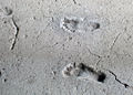 Ancient footprints of Acahualinca, Nicaragua
 -

-
 Tazumal, El Salvador
 -
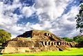
 Tikal, Guatemala
 -
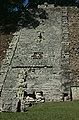 Copan, Honduras
 -
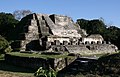 Altun Ha, Belize


.jpg)

Central America was formed more than 3 million years ago, as part of the Isthmus of Panama, when its portion of land connected each side of water.
In the Pre-Columbian era, the northern areas of Central America were inhabited by the indigenous peoples of Mesoamerica. Most notable among these were the Mayans, who had built numerous cities throughout the region, and the Aztecs, who had created a vast empire. The pre-Columbian cultures of eastern El Salvador, eastern Honduras, Caribbean Nicaragua, most of Costa Rica and Panama were predominantly speakers of the Chibchan languages at the time of European contact and are considered by some[10] culturally different and grouped in the Isthmo-Colombian Area.
Following the Spanish expedition of Christopher Columbus's voyages to the Americas, the Spanish sent many expeditions to the region, and they began their conquest of Maya territory in 1523. Soon after the conquest of the Aztec Empire, Spanish conquistador Pedro de Alvarado commenced the conquest of northern Central America for the Spanish Empire. Beginning with his arrival in Soconusco in 1523, Alvarado's forces systematically conquered and subjugated most of the major Maya kingdoms, including the K'iche', Tz'utujil, Pipil, and the Kaqchikel. By 1528, the conquest of Guatemala was nearly complete, with only the Petén Basin remaining outside the Spanish sphere of influence. The last independent Maya kingdoms – the Kowoj and the Itza people – were finally defeated in 1697, as part of the Spanish conquest of Petén.[11]
In 1538, Spain established the Real Audiencia of Panama, which had jurisdiction over all land from the Strait of Magellan to the Gulf of Fonseca. This entity was dissolved in 1543, and most of the territory within Central America then fell under the jurisdiction of the Audiencia Real de Guatemala. This area included the current territories of Costa Rica, El Salvador, Guatemala, Honduras, Nicaragua, and the Mexican state of Chiapas, but excluded the lands that would become Belize and Panama. The president of the Audiencia, which had its seat in Antigua Guatemala, was the governor of the entire area. In 1609 the area became a captaincy general and the governor was also granted the title of captain general. The Captaincy General of Guatemala encompassed most of Central America, with the exception of present-day Belize and Panama.
The Captaincy General of Guatemala lasted for more than two centuries, but began to fray after a rebellion in 1811 which began in the Intendancy of San Salvador. The Captaincy General formally ended on 15 September 1821, with the signing of the Act of Independence of Central America. Mexican independence was achieved at virtually the same time with the signing of the Treaty of Córdoba and the Declaration of Independence of the Mexican Empire, and the entire region was finally independent from Spanish authority by 28 September 1821.

.jpg)


From its independence from Spain in 1821 until 1823, the former Captaincy General remained intact as part of the short-lived First Mexican Empire. When the Emperor of Mexico abdicated on 19 March 1823, Central America again became independent. On 1 July 1823, the Congress of Central America peacefully seceded from Mexico and declared absolute independence from all foreign nations, and the region formed the Federal Republic of Central America.[citation needed]
The Federal Republic of Central America was a representative democracy with its capital at Guatemala City. This union consisted of the provinces of Costa Rica, El Salvador, Guatemala, Honduras, Los Altos, Mosquito Coast, and Nicaragua. The lowlands of southwest Chiapas, including Soconusco, initially belonged to the Republic until 1824, when Mexico annexed most of Chiapas and began its claims to Soconusco. The Republic lasted from 1823 to 1838, when it disintegrated as a result of civil wars.[citation needed]
The territory that now makes up Belize was heavily contested in a dispute that continued for decades after Guatemala achieved independence. Spain, and later Guatemala, considered this land a Guatemalan department. In 1862, Britain formally declared it a British colony and named it British Honduras. It became independent as Belize in 1981.[5]
Panama, situated in the southernmost part of Central America on the Isthmus of Panama, has for most of its history been culturally and politically linked to South America. Panama was part of the Province of Tierra Firme from 1510 until 1538 when it came under the jurisdiction of the newly formed Audiencia Real de Panama. Beginning in 1543, Panama was administered as part of the Viceroyalty of Peru, along with all other Spanish possessions in South America. Panama remained as part of the Viceroyalty of Peru until 1739, when it was transferred to the Viceroyalty of New Granada, the capital of which was located at Santa Fé de Bogotá. Panama remained as part of the Viceroyalty of New Granada until the disestablishment of that viceroyalty in 1819. A series of military and political struggles took place from that time until 1822, the result of which produced the republic of Gran Colombia. After the dissolution of Gran Colombia in 1830, Panama became part of a successor state, the Republic of New Granada. From 1855 until 1886, Panama existed as Panama State, first within the Republic of New Granada, then within the Granadine Confederation, and finally within the United States of Colombia. The United States of Colombia was replaced by the Republic of Colombia in 1886. As part of the Republic of Colombia, Panama State was abolished and it became the Isthmus Department. Despite the many political reorganizations, Colombia was still deeply plagued by conflict, which eventually led to the secession of Panama on 3 November 1903. Only after that time did some begin to regard Panama as a North or Central American entity.[citation needed]
By the 1930s the United Fruit Company owned 14,000 square kilometres (3.5 million acres) of land in Central America and the Caribbean and was the single largest land owner in Guatemala. Such holdings gave it great power over the governments of small countries. That was one of the factors that led to the coining of the phrase banana republic.[12]
After more than two hundred years of social unrest, violent conflict, and revolution, Central America today remains in a period of political transformation. Poverty, social injustice, and violence are still widespread.[13] Nicaragua is the second poorest country in the western hemisphere (only Haiti is poorer).[14]
Flags of modern Central America


Coat of arms of modern Central America


Geography

Central America is a part of North America consisting of a tapering isthmus running from the southern extent of Mexico to the northwestern portion of South America. Central America has the Gulf of Mexico, a body of water within the Atlantic Ocean, to the north; the Caribbean Sea, also part of the Atlantic Ocean, to the northeast; and the Pacific Ocean to the southwest. Some physiographists define the Isthmus of Tehuantepec as the northern geographic border of Central America,[15] while others use the northwestern borders of Belize and Guatemala. From there, the Central American land mass extends southeastward to the Atrato River, where it connects to the Pacific Lowlands in northwestern South America.
Of the many mountain ranges within Central America, the longest are the Sierra Madre de Chiapas, the Cordillera Isabelia and the Cordillera de Talamanca. At 4,220 meters (13,850 ft), Volcán Tajumulco is the highest peak in Central America. Other high points of Central America are as listed in the table below:
| Country | Name | Elevation | Range |
|---|---|---|---|
| Doyle's Delight | 1,124 m (3,688 ft) | Maya Mountains | |
| Cerro Chirripó | 3,820 m (12,530 ft) | Cordillera de Talamanca | |
| Cerro El Pital | 2,730 m (8,960 ft) | Sierra Madre de Chiapas | |
| Volcán Tajumulco | 4,220 m (13,850 ft) | Sierra Madre de Chiapas | |
| Cerro Las Minas | 2,780 m (9,120 ft) | Sierra Madre de Chiapas | |
| Mogotón | 2,107 m (6,913 ft) | Cordillera Isabelia | |
| Volcán Barú | 3,474 m (11,398 ft) | Cordillera de Talamanca |

Between the mountain ranges lie fertile valleys that are suitable for the raising of livestock and for the production of coffee, tobacco, beans and other crops. Most of the population of Honduras, Costa Rica and Guatemala lives in valleys.[16]
Trade winds have a significant effect upon the climate of Central America. Temperatures in Central America are highest just prior to the summer wet season, and are lowest during the winter dry season, when trade winds contribute to a cooler climate. The highest temperatures occur in April, due to higher levels of sunlight, lower cloud cover and a decrease in trade winds.[17]
Biodiversity
Central American forests
-
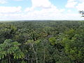 Chiquibul Forest Reserve, Belize
 -
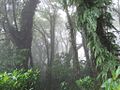
 Montecristo National Park, El Salvador
 -
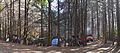
 Maderas forest, Nicaragua
 -
 Texiguat Wildlife Refuge HondurasZdroj:https://en.wikipedia.org?pojem=Central_America
Text je dostupný za podmienok Creative Commons Attribution/Share-Alike License 3.0 Unported; prípadne za ďalších podmienok. Podrobnejšie informácie nájdete na stránke Podmienky použitia.
.jpg)


Antropológia
Aplikované vedy
Bibliometria
Dejiny vedy
Encyklopédie
Filozofia vedy
Forenzné vedy
Humanitné vedy
Knižničná veda
Kryogenika
Kryptológia
Kulturológia
Literárna veda
Medzidisciplinárne oblasti
Metódy kvantitatívnej analýzy
Metavedy
Metodika
Text je dostupný za podmienok Creative
Commons Attribution/Share-Alike License 3.0 Unported; prípadne za ďalších
podmienok.
Podrobnejšie informácie nájdete na stránke Podmienky
použitia.
www.astronomia.sk | www.biologia.sk | www.botanika.sk | www.dejiny.sk | www.economy.sk | www.elektrotechnika.sk | www.estetika.sk | www.farmakologia.sk | www.filozofia.sk | Fyzika | www.futurologia.sk | www.genetika.sk | www.chemia.sk | www.lingvistika.sk | www.politologia.sk | www.psychologia.sk | www.sexuologia.sk | www.sociologia.sk | www.veda.sk I www.zoologia.sk