

A | B | C | D | E | F | G | H | CH | I | J | K | L | M | N | O | P | Q | R | S | T | U | V | W | X | Y | Z | 0 | 1 | 2 | 3 | 4 | 5 | 6 | 7 | 8 | 9
Målselv Municipality
Målselv kommune | |
|---|---|
| Maalselven herred (historic name) | |
 View of the mountain Istind on the Bardu-Målselv border | |
 Flag | |
 Troms within Norway | |
 Målselv within Troms | |
| Coordinates: 68°58′30″N 19°03′52″E / 68.97500°N 19.06444°E | |
| Country | Norway |
| County | Troms |
| District | Midt-Troms |
| Established | 1848 |
| • Preceded by | Lenviken Municipality |
| Administrative centre | Moen |
| Government | |
| • Mayor (2023) | Martin Nymo (H) |
| Area | |
| • Total | 3,324.45 km2 (1,283.58 sq mi) |
| • Land | 3,202.57 km2 (1,236.52 sq mi) |
| • Water | 121.88 km2 (47.06 sq mi) 3.7% |
| • Rank | #11 in Norway |
| Population (2023) | |
| • Total | 6,782 |
| • Rank | #148 in Norway |
| • Density | 2.1/km2 (5/sq mi) |
| • Change (10 years) | |
| Demonym | Målselvdøl[1] |
| Official language | |
| • Norwegian form | Neutral |
| Time zone | UTC+01:00 (CET) |
| • Summer (DST) | UTC+02:00 (CEST) |
| ISO 3166 code | NO-5524[3] |
| Website | Official website |

Målselv (Northern Sami: Málatvuomi suohkan) is a municipality in Troms county, Norway. The administrative centre of the municipality is the village of Moen. The main commercial centre of the municipality is the Bardufoss area (including Andselv, Andslimoen, and Heggelia). Other villages in the municipality include Alappmoen, Fossmoen, Holmen, and Skjold. Besides bordering Sweden to the east and the ocean (Malangen fjord) to the northwest, it borders the municipalities of Balsfjord, Storfjord, Bardu, Sørreisa, and Lenvik.
The 3,326-square-kilometre (1,284 sq mi) municipality is the 11th largest by area out of the 356 municipalities in Norway. Målselv is the 149th most populous municipality in Norway with a population of 6,782. The municipality's population density is 2.1 inhabitants per square kilometre (5.4/sq mi) and its population has increased by 2.3% over the previous 10-year period.[4][5]
General information
The municipality of Maalselven was established in 1848 when it was separated from the large Lenviken Municipality. The initial population of Maalselven was 2,616. In 1891, some parts of the Maalsnes area (population: 30) were transferred to neighboring Malangen Municipality. On 1 January 1904, an area with 5 inhabitants was transferred from Balsfjord Municipality to Maalselven. The spelling of the name was changed to Målselv in 1918. On 1 July 1925, the eastern district of the municipality was separated from Målselv to form the new Øverbygd Municipality. This left Målselv with 3,531 residents.[6]
During the 1960s, there were many municipal mergers across Norway due to the work of the Schei Committee. On 1 January 1964, Øverbygd Municipality (population: 1,232), Målselv Municipality (population: 5,584), the Naveren and Målsnes areas of Malangen Municipality (population: 118), and the "Skogli ved Heia" farm in Balsfjord Municipality (population: 2) were all merged to form a new, larger municipality of Målselv with a new population of 6,936. On 1 January 1966, the Sørelvmo/Aursfjordbotn area (population: 131) was transferred from Balsfjord Municipality to Målselv Municipality. Then on 1 January 1972, the "Blomli i Fagerfjell" area of Målselv Municipality (population: 63) was transferred to Lenvik Municipality.[6]
On 1 January 2020, the municipality became part of the newly formed Troms og Finnmark county. Previously, it had been part of the old Troms county.[7] On 1 January 2024, the Troms og Finnmark county was divided and the municipality once again became part of Troms county.[8]
Name
The municipality (originally the parish) is named after the river Målselva which flows through the area. The first element is the genitive case of the old uncompounded name of the Malangen fjord (malr) which means "bag" or "sack" (referring to the shape of the fjord). The last element is the finite form of elv which means "river".[9] Historically, the name of the municiaplity was spelled Maalselven. On 3 November 1917, a royal resolution changed the spelling of the name of the municipality to Maalselv, removing the definite form ending -en.[10] On 21 December 1917, a royal resolution enacted the 1917 Norwegian language reforms. Prior to this change, the name was spelled Maalselv with the digraph "aa", and after this reform, the name was spelled Målselv, using the letter å instead.[11][12]
Coat of arms
The coat of arms was granted on 1 February 1985. The official blazon is "Vert, a pile wavy argent issuant from base dexter" (Norwegian: I grønt en sølv spiss, skråstilt venstre høyre, dannet ved bølgesnitt). This means the arms have a green field (background) and the charge is a wavy line rising from the bottom left to the top right. The wavy line has a tincture of argent which means it is commonly colored white, but if it is made out of metal, then silver is used. The arms are a canting that represent the Målselva river which runs on serpentine-like loops through a fertile valley as it passes through the municipality. The green color symbolizes the fertile valley and the wavy white or silver line represents the river. The arms were designed by Ottar Jarl Myrvang.[13][14][15]
Churches
The Church of Norway has two parishes (sokn) within the municipality of Målselv. It is part of the Indre Troms prosti (deanery) in the Diocese of Nord-Hålogaland.
| Parish (sokn) | Church name | Location of the church | Year built |
|---|---|---|---|
| Målselv | Målselv Church | Målselv | 1978 |
| Øverbygd | Øverbygd Church | Øverbygd | 1867 |
| Kirkesnesmoen Chapel | Kirkesnesmoen | 1977 |
Geography
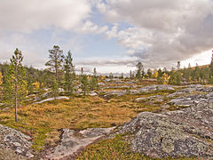
Målselv was settled by farmers from southern Norway, especially Østerdalen from 1788 and onwards. They were attracted by the vast forests and areas of fertile land in the broad Målselvdalen. The valley and municipality take their name from the river Målselva. The river is well known for its salmon, and forms the Målselv waterfall (Norwegian: Målselvfossen), which has been selected as Norway's national waterfall. The Målselva empties into the Malangen fjord north of Olsborg. There are several mountains in the municipality: Njunis (1,713 m or 5,620 ft) is the highest and Istind is popular among hikers. There are many lakes such as Andsvatnet, Finnfjordvatnet, Rostojávri, Lille Rostavatn, and Takvatnet. One of the rarest orchids in Europe, Lysiella oligantha (Norwegian: Sibirnattfiol), is found in Målselv. Øvre Dividal National Park (740 km2 or 290 sq mi) is located in the easternmost part of Målselv, near the border with Sweden.
Media gallery
-
 Målselv kirke
 -
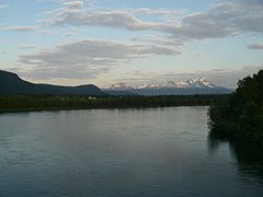 Målselv river and valley
 -
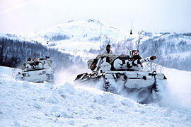 The Norwegian Armed Forces has a long history in Målselv
 -
 Heggelia in Målselv
 -
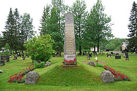 Memorial for those killed during WW2 in Målselv
 -
 Øvre Dividal national park
 -
 Blåtindan mountain
.jpg)
.jpg)


.jpg)


Climate
Målselv has a boreal climate (Köppen climate classification: Dfc) with cold winters, and with spring and early summer as the driest season.
Målselv is fairly sheltered from the coastal weather, and has a somewhat inland climate. The all-time high 33.5 °C (92.3 °F) is from July 2018, while the warmest month on record at Bardufoss Airport is July 2014 with average daily high 23.4 °C (74.1 °F) and mean 17.7 °C (63.9 °F). The all-time low −38.1 °C (−36.6 °F) was recorded December 1978. The coldest month recorded is February 1966 with mean −18.1 °C (−0.6 °F) and average daily low −23 °C (−9 °F). Mean annual precipitation is 703 millimetres (27.7 in) at Bardufoss and only 282 millimetres (11.1 in) in the Divi valley, which sits at 282 m (925 ft) above sea level.[16]
There is on average 93 days each winter with daily low −10 °C (14 °F) or colder, and 28 days with low −20 °C (−4 °F) or colder. The winter season sees on average 68 days with at least 50 centimetres (20 in) snow cover on the ground, 126 days with at least 25 centimetres (9.8 in) snow cover, and 179 days with at least 5 centimetres (2.0 in) snow cover. In the warm season there is on average 116 days each year when the daily average high reaches 10 °C (50 °F) or warmer and 22 days with daily average high above 20 °C (68 °F). Precipitation is fairly moderate, there is on average 75 days per year with at least 3 millimetres (0.12 in) precipitation and 15 days per year with at least 10 millimetres (0.39 in) precipitation. This is based on data from Met.no with 1971–2000 as base period.[17] The average date for first overnight freeze (below 0 °C (32 °F)) in autumn is 4 September (1981-2010 average).[18]
| Climate data for Bardufoss 1991-2020 (76 m, extremes 1940-2020) | |||||||||||||
|---|---|---|---|---|---|---|---|---|---|---|---|---|---|
| Month | Jan | Feb | Mar | Apr | May | Jun | Jul | Aug | Sep | Oct | Nov | Dec | Year |
| Record high °C (°F) | 8.9 (48.0) |
9 (48) |
11.9 (53.4) |
17.5 (63.5) |
27.7 (81.9) |
31.1 (88.0) |
33.5 (92.3) |
32.2 (90.0) |
23.7 (74.7) |
20 (68) |
12.2 (54.0) |
10.1 (50.2) |
33.5 (92.3) |
| Mean daily maximum °C (°F) | −6 (21) |
−5 (23) |
0 (32) |
5 (41) |
11 (52) |
14 (57) |
18 (64) |
17 (63) |
12 (54) |
5 (41) |
−1 (30) |
−4 (25) |
6 (42) |
| Daily mean °C (°F) | −9.7 (14.5) |
−9.1 (15.6) |
−5.1 (22.8) |
0.6 (33.1) |
6 (43) |
10.7 (51.3) |
13.7 (56.7) |
12.3 (54.1) |
7.4 (45.3) |
0.8 (33.4) |
−4.7 (23.5) |
−7.8 (18.0) |
1.3 (34.3) |
| Mean daily minimum °C (°F) | −13 (9) |
−12 (10) |
−9 (16) |
−3 (27) |
2 (36) |
7 (45) |
10 (50) |
8 (46) |
4 (39) |
−1 (30) |
−7 (19) |
−10 (14) |
−2 (28) |
| Record low °C (°F) | −36.2 (−33.2) |
−34.8 (−30.6) |
−31.7 (−25.1) |
−25.1 (−13.2) |
−11.2 (11.8) |
−2 (28) |
0.6 (33.1) |
−4 (25) |
−12.4 (9.7) |
−25.5 (−13.9) |
−29.8 (−21.6) |
−38.1 (−36.6) |
−38.1 (−36.6) |
| Average precipitation mm (inches) | 68.9 (2.71) |
58.5 (2.30) |
62.4 (2.46) |
34.2 (1.35) |
34.4 (1.35) |
45.5 (1.79) |
62.7 (2.47) |
64.6 (2.54) |
71.4 (2.81) |
72 (2.8) |
56.4 (2.22) |
72.5 (2.85) |
703.5 (27.65) |
| Source 1: Weatheronline (avg high/low)[19] | |||||||||||||
| Source 2: yr.no/met.no/eklima (mean, precipitation, extremes)[20] | |||||||||||||
| Climate data for Bardufoss 1961–90 (76 m) | |||||||||||||
|---|---|---|---|---|---|---|---|---|---|---|---|---|---|
| Month | Jan | Feb | Mar | Apr | May | Jun | Jul | Aug | Sep | Oct | Nov | Dec | Year |
| Mean daily maximum °C (°F) | −5.9 (21.4) |
−4.5 (23.9) |
−0.4 (31.3) |
3.8 (38.8) |
9.3 (48.7) |
14.8 (58.6) |
17.4 (63.3) |
15.8 (60.4) |
10.5 (50.9) |
4.3 (39.7) |
−1.7 (28.9) |
−4.7 (23.5) |
4.9 (40.8) |
| Daily mean °C (°F) | −10.4 (13.3) |
−8.9 (16.0) |
−5.4 (22.3) |
−0.2 (31.6) |
5.6 (42.1) |
10.5 (50.9) |
13.0 (55.4) |
11.5 (52.7) |
6.3 (43.3) |
0.9 (33.6) |
−5.5 (22.1) |
−8.9 (16.0) |
0.7 (33.3) |
| Mean daily minimum °C (°F) | −15.1 (4.8) |
−13.7 (7.3) |
−10.9 (12.4) |
−5.1 (22.8) |
1.1 (34.0) |
6.2 (43.2) |
8.8 (47.8) |
6.9 (44.4) |
2.5 (36.5) |
−2.5 (27.5) |
−9.4 (15.1) |
−13.6 (7.5) |
−3.7 (25.3) |
| Average precipitation mm (inches) | 66 (2.6) |
58 (2.3) |
40 (1.6) |
33 (1.3) |
24 (0.9) |
38 (1.5) |
57 (2.2) |
63 (2.5) |
64 (2.5) |
77 (3.0) |
64 (2.5) |
68 (2.7) |
652 (25.7) |
| Average precipitation days (≥ 1 mm) | 11.2 | 11.4 | 9.3 | 7.8 | 6.8 | 8.9 | 11.7 | 12.7 | 12.9 | 13.7 | 12.0 | 12.5 | 130.9 |
| Source: Norwegian Meteorological Institute[21] | |||||||||||||
Government
All municipalities in Norway are responsible for primary education (through 10th grade), outpatient health services, senior citizen services, welfare and other social services, zoning, economic development, and municipal roads and utilities. The municipality is governed by a municipal council of directly elected representatives. The mayor is indirectly elected by a vote of the municipal council.[22] The municipality is under the jurisdiction of the Nord-Troms og Senja District Court and the Hålogaland Court of Appeal.
Municipal council
The municipal council (Kommunestyre) of Målselv is made up of 23 representatives that are elected to four-year terms. The tables below show the current and historical composition of the council by political party.
| Party name (in Norwegian) | Number of representatives | |
|---|---|---|
| Labour Party (Arbeiderpartiet) | 8 | |
| Progress Party (Fremskrittspartiet) | 2 | |
| Conservative Party (Høyre) | 5 | |
| Red Party (Rødt) | 1 | |
| Centre Party (Senterpartiet) | 5 | |
| Socialist Left Party (Sosialistisk Venstreparti) | 1 | |
| Liberal Party (Venstre) | 1 | |
| Total number of members: | 23 | |
| Party name (in Norwegian) | Number of representatives | |
|---|---|---|
| Labour Party (Arbeiderpartiet) | 7 | |
| Progress Party (Fremskrittspartiet) | 1 | |
| Conservative Party (Høyre) | 2 | |
| Red Party (Rødt) | 1 | |
| Centre Party (Senterpartiet) | 10 | |
| Socialist Left Party (Sosialistisk Venstreparti) | 1 | |
| Liberal Party (Venstre) | 1 | |
| Total number of members: | 23 | |
| Party name (in Norwegian) | Number of representatives | |
|---|---|---|
| Labour Party (Arbeiderpartiet) | 11 | |
| Progress Party (Fremskrittspartiet) | 2 | |
| Conservative Party (Høyre) | 4 | |
| Centre Party (Senterpartiet) | 4 | |
| Socialist Left Party (Sosialistisk Venstreparti) | 1 | |
| Liberal Party (Venstre) | 3 | |
| Total number of members: | 25 | |
| Party name (in Norwegian) | Number of representatives | |
|---|---|---|
| Labour Party (Arbeiderpartiet) | 10 | |
| Progress Party (Fremskrittspartiet) | 3 | |
| Conservative Party (Høyre) | 5 | |
| Centre Party (Senterpartiet) | 3 | |
| Socialist Left Party (Sosialistisk Venstreparti) | 1 | |
| Liberal Party (Venstre) | 3 | |
| Total number of members: | 25 | |
| Party name (in Norwegian) | Number of representatives | |
|---|---|---|
| Labour Party (Arbeiderpartiet) | 13 | |
| Progress Party (Fremskrittspartiet) | 5 | |
| Conservative Party (Høyre) | 3 | |
| Centre Party (Senterpartiet) | 4 | |
| Liberal Party (Venstre) | 2 | |
| Joint list of the Red Electoral Alliance (Rød Valgallianse) and the Socialist Left Party (Sosialistisk Venstreparti) | 2 | |
| Total number of members: | 29 | |
| Party name (in Norwegian) | Number of representatives | |
|---|---|---|
| Labour Party (Arbeiderpartiet) | 11 | |
| Progress Party (Fremskrittspartiet) | 3 | |
| Conservative Party (Høyre) | 4 | |
| The Democrats (Demokratene) | 1 | |
| Centre Party (Senterpartiet) | 4 | |
| Liberal Party (Venstre) | 3 | |
| Joint list of the Red Electoral Alliance (Rød Valgallianse) and the Socialist Left Party (Sosialistisk Venstreparti) | 3 | |
| Total number of members: | 29 | |
| Party name (in Norwegian) | Number of representatives | |
|---|---|---|
| Labour Party (Arbeiderpartiet) | 8 | |
| Progress Party (Fremskrittspartiet) | 3 | |
| Conservative Party (Høyre) | 6 | |
| Red Electoral Alliance (Rød Valgallianse) | 1 | |
| Centre Party (Senterpartiet) | 6 | |
| Liberal Party (Venstre) | 5 | |
| Total number of members: | 29 | |