A | B | C | D | E | F | G | H | CH | I | J | K | L | M | N | O | P | Q | R | S | T | U | V | W | X | Y | Z | 0 | 1 | 2 | 3 | 4 | 5 | 6 | 7 | 8 | 9
Waco | |
|---|---|
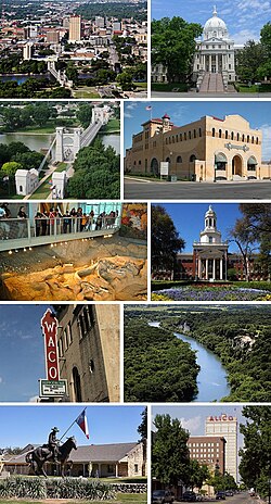
 From left to right, top to bottom: Downtown, McLennan County Courthouse, Waco Suspension Bridge, Dr. Pepper Museum, Waco Mammoth National Monument, Baylor University, Waco Hippodrome, Cameron Park, Texas Ranger Hall of Fame and Museum, and Austin Avenue in Downtown | |
| Nickname(s): "Heart of Texas" "Buckle of the Bible Belt"[1] | |
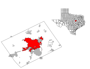
 Location within McLennan County and Texas | |
| Coordinates: 31°33′5″N 97°9′21″W / 31.55139°N 97.15583°W | |
| Country | United States |
| State | Texas |
| County | McLennan |
| Named for | The Waco people |
| Government | |
| • Type | Council–manager |
| • Mayor | Dillon Meek |
| • City council | Council members
|
| • City manager | Bradley Ford |
| Area | |
| • City | 101.15 sq mi (261.98 km2) |
| • Land | 88.73 sq mi (229.82 km2) |
| • Water | 12.42 sq mi (32.16 km2) 11.85% |
| Elevation | 470 ft (143.3 m) |
| Population (2020) | |
| • City | 138,486 |
| • Estimate (2023)[3] | 144,816 |
| • Density | 1,569.16/sq mi (605.86/km2) |
| • Urban | 192,844 (US: 201st) |
| • Urban density | 2,145.6/sq mi (828.4/km2) |
| • Metro | 304,865 (US: 168th) |
| Demonym | Wacoan |
| Time zone | UTC−6 (Central) |
| • Summer (DST) | UTC−5 (Central) |
| ZIP Codes | 76701-76708, 76710-76712, 76714-76716, 76797-76799 |
| Area code | 254 |
| FIPS code | 48-76000[5] |
| GNIS feature ID | 1370701[6] |
| Website | Waco-Texas.com |
Waco (/ˈweɪkoʊ/ WAY-koh) is a city in and the county seat of McLennan County, Texas, United States.[7] It is situated along the Brazos River and I-35, halfway between Dallas and Austin. The city had a U.S. census estimated 2023 population of 144,816, making it the 24th-most populous city in the state.[8][9] The Waco metropolitan statistical area consists of McLennan, Falls and Bosque counties, which had a 2020 population of 295,782.[10] Bosque County was added to the Waco MSA in 2023. The 2023 U.S. census population estimate for the Waco metropolitan area was 304,865 residents.[11]
History
1824–1865
Indigenous peoples occupied areas along the river for thousands of years. In historic times, the area of present-day Waco was occupied by the Wichita Indian tribe known as the "Waco" (Spanish: Hueco or Huaco).
In 1824, Thomas M. Duke was sent to explore the area after violence erupted between the Waco people and the European settlers. His report to Stephen F. Austin, described the Waco village:[12]
This town is situated on the West Bank of the river. They have a spring almost as cold as ice itself. All we want is some Brandy and Sugar to have Ice Toddy. They have about 400 acres (1.6 km2) planted in corn, beans, pumpkins, and melons and that tended in good order. I think they cannot raise more than One Hundred Warriors.
— Thomas M. Duke, Stephen F. Austin Papers
After further violence, Austin halted an attempt to destroy their village in retaliation. In 1825, he made a treaty with them. The Waco were eventually pushed out of the region, settling north near present-day Fort Worth. In 1872, they were moved onto a reservation in Oklahoma with other Wichita tribes. In 1902, the Waco received allotments of land and became official US citizens. Neil McLennan settled in an area near the South Bosque River in 1838.[13] Jacob De Cordova bought McLennan's property[14] and hired a former Texas Ranger and surveyor named George B. Erath to inspect the area.[15] In 1849, Erath designed the first block of the city. Property owners wanted to name the city Lamartine, but Erath convinced them to name the area Waco Village, after the Indians who had lived there.[16] In March 1849, Shapley Prince Ross, the father of future Governor Lawrence Sullivan Ross, built the first house in Waco, a double-log cabin, on a bluff overlooking the springs. His daughter Kate was the first settler child born in Waco. Because of this, Ross is considered to have been the founder of Waco, Texas.[17]
1866–1900


In 1866, Waco's leading citizens embarked on an ambitious project to build the first bridge to span the wide Brazos River. They formed the Waco Bridge Company to build the 475-foot (145 m) brick Waco Suspension Bridge, which was completed in 1870. The company commissioned a firm owned by John Augustus Roebling in Trenton, New Jersey, to supply the bridge's cables and steelwork and contracted with Mr. Thomas M. Griffith, a civil engineer based in New York, for the supervisory engineering work.[18] The economic effects of the Waco bridge were immediate and large. The cowboys and cattle-herds following the Chisholm Trail north, crossed the Brazos River at Waco. Some chose to pay the Suspension Bridge toll, while others floated their herds down the river. The population of Waco grew rapidly, as immigrants now had a safe crossing for their horse-drawn carriages and wagons. Since 1971, the bridge has been open only to pedestrian traffic and is in the National Register of Historic Places.
Waco was the original intended western terminus of the Texas and St. Louis Railway, with the town having been reached in 1881.[19] However, the line was extended further west to Gatesville a year later.[20][21] This trackage later became the core of the St. Louis Southwestern Railway Company, commonly known as the Cotton Belt.[22]
In the late 19th century, a red-light district called the "Reservation" grew up in Waco, and prostitution was regulated by the city. The Reservation was suppressed in the early 20th century. In 1885, the soft drink Dr Pepper was invented in Waco at Morrison's Old Corner Drug Store.[23]
In 1845, Baylor University was founded in Independence, Texas. It moved to Waco in 1886 and merged with Waco University, becoming an integral part of the city. The university's Strecker Museum was also the oldest continuously operating museum in the state until it closed in 2003, and the collections moved to the new Mayborn Museum Complex. In 1873, AddRan College was founded by brothers Addison and Randolph Clark in Fort Worth. The school moved to Waco in 1895, changing its name to Add-Ran Christian University and taking up residence in the empty buildings of Waco Female College. Add-Ran changed its name to Texas Christian University in 1902 and left Waco after the school's main building burned down in 1910.[24] TCU was offered a 50-acre (200,000 m2) campus and $200,000 by the city of Fort Worth to relocate there.[24]
Racial segregation was common in Waco. For example, Greenwood Cemetery was established in the 1870s as a segregated burial place. Black graves were divided from white ones by a fence which remained standing until 2016.[25]

In the 1890s, William Cowper Brann published the highly successful Iconoclast newspaper in Waco. One of his targets was Baylor University. Brann revealed Baylor officials had been trafficking South American children recruited by missionaries and making house-servants out of them. Brann was shot in the back by Tom Davis, a Baylor supporter. Brann then wheeled, drew his pistol, and killed Davis. Brann was helped home by his friends, and died there of his wounds.
In 1894, the first Cotton Palace fair and exhibition center was built to reflect the dominant contribution of the agricultural cotton industry in the region. Since the end of the Civil War, cotton had been cultivated in the Brazos and Bosque valleys, and Waco had become known nationwide as a top producer. Over the next 23 years, the annual exposition would welcome over eight million attendees. The opulent building which housed the month-long exhibition was destroyed by fire and rebuilt in 1910. In 1931, the exposition fell prey to the Great Depression, and the building was torn down. However, the annual Cotton Palace Pageant continues, hosted in late April in conjunction with the Brazos River Festival.
On September 15, 1896, "The Crash" took place about 15 miles (24 km) north of Waco. "The Crash at Crush" was a publicity stunt done by the Missouri–Kansas–Texas Railroad company (known as M-K-T or "Katy"), featuring two locomotives intentionally set to a head-on collision. Meant to be a family fun event with food, games, and entertainment, the Crash turned deadly when both boilers exploded simultaneously, sending metal flying in the air. Three people died and dozens were injured.[26]
20th century

An African American man named Sank Majors was hanged from the Washington Avenue Bridge by a white mob in 1905. Another man, Jim Lawyer, was attacked with a whip because he objected to the lynching. In both cases the mob was assisted by Texas Rangers.[27]

In 1916, a Black teenager named Jesse Washington was tortured, mutilated, and burned to death in the town square by a mob that seized him from the courthouse, where he had been convicted of murdering a white woman, to which he confessed. About 15,000 spectators, mostly citizens of Waco, were present. The commonly named Waco Horror drew international condemnation and became the cause célèbre of the nascent NAACP's anti-lynching campaign. In 2006, the Waco City Council officially condemned the lynching, which took place without opposition from local political or judicial leaders; the mayor and chief of police were spectators. On the centenary of the lynching, May 15, 2016, the mayor apologized in a ceremony to some of Washington's descendants. A historical marker is being erected.[28]
In the 1920s, despite the popularity of the Ku Klux Klan and high numbers of lynchings throughout Texas, Waco's authorities attempted to respond to the NAACP's campaign and institute more protections for African Americans or others threatened with mob violence and lynching.[29] On May 26, 1922, Jesse Thomas was shot, his body dragged down Franklin street by a crowd some 6,000 strong and the corpse then burned in the public square behind city hall.[30] In 1923, Waco's sheriff Leslie Stegall protected Roy Mitchell, an African American coerced into confessing to multiple murders, from mob lynching. Mitchell was the last Texan to be publicly executed in Texas, and also the last to be hanged before the introduction of the electric chair.[29] In the same year, the Texas Legislature created the Tenth Civil Court of Appeals and placed it in Waco; it is now known as the 10th Court of Appeals.
In 1937, Grover C. Thomsen and R. H. Roark created a soft-drink called "Sun Tang Red Cream Soda". This would become known as the soft drink Big Red.
On May 5, 1942, Waco Army Air Field opened as a basic pilot training school, and on June 10, 1949, the name was changed to Connally Air Force Base in memory of Col. James T. Connally, a local pilot killed in Japan in 1945. The name changed again in 1951 to the James Connally Air Force Base. The base closed in May 1966 and is now the location of Texas State Technical College, formerly Texas State Technical Institute, since 1965. The airfield is still in operation, now known as TSTC Waco Airport, and was used by Air Force One when former US President George W. Bush visited his Prairie Chapel Ranch, also known as the Western White House, in Crawford, Texas.
In 1951, Harold Goodman founded the American Income Life Insurance Company.

On May 11, 1953, a violent F5 tornado hit downtown Waco, killing 114.[31] As of 2011, it remains the 11th-deadliest tornado in U.S. history and tied for the deadliest in Texas state history.[32] It was the first tornado tracked by radar and helped spur the creation of a nationwide storm surveillance system. A granite monument featuring the names of those killed was placed downtown in 2004.[33]
In 1964, the Texas Department of Public Safety designated Waco as the site for the state-designated official museum of the legendary Texas Rangers law enforcement agency founded in 1823. In 1976, it was further designated the official Hall of Fame for the Rangers and renamed the Texas Ranger Hall of Fame and Museum. Renovations by the Waco government earned this building green status, the first Waco government-led project of its nature. The construction project has fallen under scrutiny for expanding the building over unmarked human graves.
In 1978, bones were discovered emerging from the mud at the confluence of the Brazos and Bosque Rivers. Excavations revealed the bones were 68,000 years old and belonged to a species of mammoth. Eventually, the remains of at least 24 mammoths, one camel, and one large cat were found at the site, making it one of the largest findings of its kind. Scholars have puzzled over why such a large herd had been killed at once. The bones are on display at the Waco Mammoth National Monument, part of the National Park Service.

Waco siege
On February 28, 1993, a shootout occurred in which six Branch Davidians and four agents of the United States Bureau of Alcohol, Tobacco, and Firearms died. After 51 days, on April 19, 1993, the standoff ended when the Branch Davidians' facility, referred to as Mt. Carmel, was set ablaze, thirteen miles from Waco.[34] 74 people, including leader David Koresh, died in the blaze.
21st century
During the presidency of George W. Bush, Waco was the home to the White House Press Center. The press center provided briefing and office facilities for the press corps whenever Bush visited his "Western White House" Prairie Chapel Ranch near Crawford, about 25 miles (40 km) northwest of Waco.
On May 17, 2015, a violent dispute among rival biker gangs broke out at Twin Peaks restaurant. The Waco police intervened, with nine dead and 18 injured in the incident. More than 170 were arrested.[35] No bystanders, Twin Peak employees, or officers were killed. This was the most high-profile criminal incident since the Waco siege, and the deadliest shootout in the city's history.
Geography

According to the United States Census Bureau, the city has an area of 95.5 square miles (247 km2), of which 84.2 square miles (218 km2) is land and 11.3 square miles (29 km2) is covered by water. The total area is 11.85% water.
Cityscape
Downtown Waco is relatively small when compared to other larger Texas cities, such as Houston, Dallas, San Antonio, or even Fort Worth, El Paso, or Austin. The 22-story ALICO Building, completed in 1910, is the tallest building in Waco.[36]
Climate
Waco experiences a humid subtropical climate (Köppen climate classification Cfa), characterized by hot summers and generally mild winters. Some 90 °F (32 °C) temperatures have been observed in every month of the year. The record low temperature is −5 °F (−21 °C), set on January 31, 1949; the record high temperature is 114 °F (46 °C), set on July 23, 2018.[37]
| Climate data for Waco Regional Airport, Texas, 1991–2020 normals, extremes 1901–present | |||||||||||||
|---|---|---|---|---|---|---|---|---|---|---|---|---|---|
| Month | Jan | Feb | Mar | Apr | May | Jun | Jul | Aug | Sep | Oct | Nov | Dec | Year |
| Record high °F (°C) | 90 (32) |
96 (36) |
100 (38) |
101 (38) |
102 (39) |
109 (43) |
114 (46) |
112 (44) |
111 (44) |
101 (38) |
92 (33) |
91 (33) |
114 (46) |
| Mean maximum °F (°C) | 78.3 (25.7) |
81.5 (27.5) |
85.7 (29.8) |
89.9 (32.2) |
94.5 (34.7) |
99.1 (37.3) |
103.0 (39.4) |
103.8 (39.9) |
99.9 (37.7) |
93.6 (34.2) |
84.3 (29.1) |
79.0 (26.1) |
105.1 (40.6) |
| Mean daily maximum °F (°C) | 59.1 (15.1) |
63.1 (17.3) |
70.2 (21.2) |
77.9 (25.5) |
85.3 (29.6) |
92.7 (33.7) |
96.7 (35.9) |
97.1 (36.2) |
90.8 (32.7) |
80.7 (27.1) |
68.8 (20.4) |
60.4 (15.8) |
78.6 (25.9) |
| Daily mean °F (°C) | 47.4 (8.6) |
51.6 (10.9) |
58.8 (14.9) |
66.2 (19.0) |
74.3 (23.5) |
81.9 (27.7) |
85.6 (29.8) |
85.5 (29.7) |
78.7 (25.9) |
68.4 (20.2) |
57.2 (14.0) |
49.2 (9.6) |
67.1 (19.5) |
| Mean daily minimum °F (°C) | 35.8 (2.1) |
40.1 (4.5) |
47.4 (8.6) |
54.6 (12.6) |
63.3 (17.4) |
71.1 (21.7) |
74.4 (23.6) |
73.9 (23.3) |
66.7 (19.3) |
56.2 (13.4) |
45.6 (7.6) |
37.9 (3.3) |
55.6 (13.1) |
| Mean minimum °F (°C) | 20.6 (−6.3) |
24.6 (−4.1) |
28.4 (−2.0) |
37.2 (2.9) |
47.5 (8.6) |
61.2 (16.2) |
68.1 (20.1) |
66.5 (19.2) |
52.6 (11.4) |
38.2 (3.4) |
27.6 (−2.4) |
22.9 (−5.1) |
18.2 (−7.7) |
| Record low °F (°C) | −5 (−21) |
−1 (−18) |
15 (−9) |
26 (−3) |
34 (1) |
52 (11) |
58 (14) |
53 (12) |
39 (4) |
25 (−4) |
17 (−8) |
−4 (−20) |
−5 (−21) |
| Average precipitation inches (mm) | 2.59 (66) |
2.68 (68) |
3.31 (84) |
3.30 (84) |
4.44 (113) |
3.35 (85) |
1.82 (46) |
2.05 (52) |
2.87 (73) |
4.41 (112) |
2.71 (69) |
2.87 (73) |
36.40 (925) |
| Average snowfall inches (cm) | 0.0 (0.0) |
0.4 (1.0) |
0.1 (0.25) |
0.1 (0.25) |
0.0 (0.0) |
0.0 (0.0) |
0.0 (0.0) |
0.0 (0.0) |
0.0 (0.0) |
0.0 (0.0) |
0.1 (0.25) |
0.0 (0.0) |
0.7 (1.75) |
| Average precipitation days (≥ 0.01 in) | 7.2 | 6.9 | 8.1 | 7.1 | 8.3 | 6.5 | 4.7 | 4.9 | 5.8 | 6.7 | 6.9 | 7.1 | 80.2 |
| Average snowy days (≥ 0.1 in) | 0.0 | 0.3 | 0.1 | 0.1 | 0.0 | Zdroj:https://en.wikipedia.org?pojem=Waco,_Texas||||||||


