A | B | C | D | E | F | G | H | CH | I | J | K | L | M | N | O | P | Q | R | S | T | U | V | W | X | Y | Z | 0 | 1 | 2 | 3 | 4 | 5 | 6 | 7 | 8 | 9
Tower Hamlets | |
|---|---|
| |
| Motto: From Great Things to Greater | |
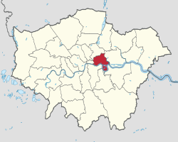
 Tower Hamlets shown within Greater London | |
| Sovereign state | United Kingdom |
| Constituent country | England |
| Region | London |
| Ceremonial county | Greater London |
| Created | 1 April 1965 |
| Admin HQ | 160 Whitechapel Rd, London E1 1BJ |
| Government | |
| • Type | London borough council |
| • Body | Tower Hamlets London Borough Council |
| • London Assembly | Unmesh Desai (Labour) AM for City and East |
| • MPs | Rushanara Ali (Labour) Apsana Begum (Labour) |
| Area | |
| • Total | 7.63 sq mi (19.77 km2) |
| • Rank | 290th (of 296) |
| Population (2022) | |
| • Total | 325,789 |
| • Rank | 37th (of 296) |
| • Density | 43,000/sq mi (16,000/km2) |
| Time zone | UTC (GMT) |
| • Summer (DST) | UTC+1 (BST) |
| Postcodes | |
| ONS code | 00BG |
| GSS code | E09000030 |
| Police | Metropolitan Police |
| Website | www |
The London Borough of Tower Hamlets is a borough of London, England. Situated on the north bank of the River Thames and immediately east of the City of London, the borough spans much of the traditional East End of London and includes much of the regenerated London Docklands area. The 2019 mid-year population for the borough is estimated at 324,745.
Tower Hamlets occupies much of what is traditionally known as the East End of London, a working-class area once infamous for its high population density and poverty. Some of the tallest buildings in London occupy Canary Wharf, one of the country's largest financial districts, in the south of the borough. A part of the Queen Elizabeth Olympic Park is in Tower Hamlets. It was formed in 1965 by merger of the former metropolitan boroughs of Stepney, Poplar, and Bethnal Green. 'Tower Hamlets' was originally an alternative name for the historic Tower Division; the area of south-east Middlesex, focused on (but not limited to) the area of the modern borough, which owed military service to the Tower of London.
The local authority is Tower Hamlets London Borough Council. In 2017, a joint study by Trust for London and New Policy Institute found Tower Hamlets to be the 2nd most deprived London borough (after Barking and Dagenham) based on an average calculated across a range of indicators; with high rates of poverty, child poverty, unemployment and pay inequality compared to other London boroughs.[1] However, it has the lowest gap for educational outcomes at secondary level.[2]
Demographically, Tower Hamlets has the United Kingdom's largest population of British Bangladeshis, forming the largest single ethnic group in the borough at 32%.[3] The 2011 census showed Tower Hamlets to have the highest proportion of Muslims of any English local authority and was the only location where Muslims outnumbered Christians.[4] The borough has more than 40 mosques, Islamic centres and madrasahs,[5] including the East London Mosque, Britain's largest.[6] Brick Lane's restaurants, neighbouring street market and shops provide the largest range of Bangladeshi cuisine, woodwork, carpets and clothes in Europe.[7][8] The Lane is also a major centre of hipster subculture.[9][10][11]
History
This section needs additional citations for verification. (June 2023) |
The earliest reference to the name "Tower Hamlets" was in 1554, when the Council of the Tower of London ordered a muster of "men of the hamlets which owe their service to the tower". This covered a wider area than the present-day borough, and its military relationship with the Tower is thought to have been several centuries earlier than the 1554 record.[12]

In 1605, the Lieutenant of the Tower was given the right to muster the militia and the area east of the tower came to be a distinct military unit, officially called Tower Hamlets (or the Tower Division).[13] The Hamlets of the Tower paid taxes for the militia in 1646.[14]
The London Borough of Tower Hamlets forms the core of the East End. The population of the area grew enormously in the 19th century, leading to extreme overcrowding and a concentration of poor people and immigrants throughout the area.[note 1] These problems were exacerbated by the construction of St Katharine Docks (1827)[note 2] and the central London railway termini (1840–1875) with many displaced people moving into the area following the clearance of former slums and rookeries. Over the course of a century, the East End became synonymous with poverty, overcrowding, disease and criminality.[15]
The area was once characterised by rural settlements clustered around the City walls or along the main roads, surrounded by farmland, with marshes and small communities by the River, serving the needs of shipping and the Royal Navy. Until the arrival of formal docks, shipping was required to land goods in the Pool of London, but industries related to construction, repair, and victualling of ships flourished in the area from Tudor times. The area attracted large numbers of rural people looking for employment. Successive waves of foreign immigration began with Huguenot refugees creating a new extramural suburb in Spitalfields in the 17th century.[16] They were followed by Irish weavers,[17] Ashkenazi Jews[18] and, in the 20th century, Bangladeshis.[19]

Many of these immigrants worked in the clothing industry. The abundance of semi- and unskilled labour led to low wages and poor conditions throughout the East End. This brought the attentions of social reformers during the mid-18th century and led to the formation of unions and workers associations at the end of the century. The radicalism of the East End contributed to the formation of the Labour Party and demands for the enfranchisement of women.
Official attempts to address the overcrowded housing began at the beginning of the 20th century under the London County Council. Aerial bombing in World War II devastated much of the East End, with its docks, railways and industry forming a continual target. In the separate boroughs making up today's Tower Hamlets a total of 2,221 civilians were killed and 7,472 were injured, with 46,482 houses destroyed and 47,574 damaged.[20] This led to some dispersal of the population to outlying suburbs. New housing was built in the 1950s for those that remained.[15]
The closure of the last of the East End docks in the Port of London in 1980 created further challenges and led to attempts at regeneration and the formation of the London Docklands Development Corporation. The Canary Wharf development, improved infrastructure, and the Queen Elizabeth Olympic Park[21] mean that the East End is undergoing further change, but some of its districts continue to see some of the worst poverty in Britain.[22]
Administrative history
The area of the modern borough had historically been part of the hundred of Ossulstone in county of Middlesex. Ossulstone was subsequently divided into four divisions, one of which was the Tower Division, also known as the Tower Hamlets, which covered a larger area than the modern borough, also including parts of Hackney. From at least the 17th century the Tower Division was a liberty with judicial and administrative independence from the rest of the county. The liberty appears to have arisen from much older obligations on inhabitants of the area to provide military service to the Constable of the Tower of London.[23]
From 1856 the area was governed by the Metropolitan Board of Works, which was established to provide services across the metropolis of London.[24] In 1889 the Metropolitan Board of Works' area was made the County of London. From 1856 until 1900 the lower tier of local government within the metropolis comprised various parish vestries and district boards. In 1900 the lower tier was reorganised into metropolitan boroughs, including the Metropolitan Borough of Bethnal Green, the Metropolitan Borough of Poplar and the Metropolitan Borough of Stepney.[25][26]
The modern borough was created in 1965 under the London Government Act 1963. It was a merger of the old boroughs of Bethnal Green, Poplar and Stepney, and was named Tower Hamlets after the historic liberty.[25]
Geography
This section needs additional citations for verification. (June 2023) |

Tower Hamlets is in East London, north of the River Thames. The City of London lies to the west, the London Borough of Hackney to the north, while the River Lea forms the boundary with the London Borough of Newham to the east. The River Lea also forms the boundary between the historic counties of Middlesex and Essex. The borough's Thames frontage extends from the Tower Dock inlet,[note 3] immediately west of the Tower of London, through several miles of former docklands, including the Isle of Dogs peninsula, to the confluence of the Thames and Lea at Blackwall. Areas along the Thames and Lea flood plains were historically frequently flooded, but the Thames Barrier, further east, has reduced that risk.
Regent's Canal enters the borough from Hackney to meet the River Thames at Limehouse Basin. A stretch of the Hertford Union Canal leads from the Regent's canal, at a basin in the north of Mile End, to join the River Lea at Old Ford. A further canal, Limehouse Cut, London's oldest, leads from locks at Bromley-by-Bow to Limehouse Basin. Most of the canal tow-paths are open to both pedestrians and cyclists.
The borough includes open spaces such as Victoria Park, King Edward Memorial Park, Mile End Park, Island Gardens and part of the Queen Elizabeth Olympic Park.

in the Borough of Tower Hamlets
Districts within the borough
Areas within the borough include:
Landmarks

- Brick Lane
- Cable Street - site of the Battle of Cable Street
- Hawksmoor's Christ Church, Spitalfields
- Site of two historic Royal Mints
- Tower of London
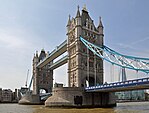
- Tower Bridge
- Victoria Park
- Roman Road
- Columbia Road
- Poplar Baths
Parts of this article (those related to the proposed Chinese embassy move) need to be updated. (December 2022) |
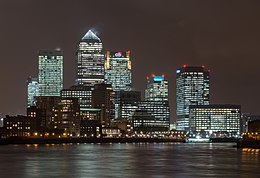
The Canary Wharf complex within Docklands on the Isle of Dogs forms a group of some of the tallest buildings in Europe. One Canada Square was the first to be constructed and is the third tallest in London. Nearby are the HSBC Tower, Citigroup Centres and One Churchill Place, headquarters of Barclays Bank. Within the same complex are the Heron Quays offices.
Part of the Queen Elizabeth Olympic Park, developed for the London 2012 Olympics, lies within the borders of Tower Hamlets.
The Embassy of China in London will move into the former Royal Mint building in East Smithfield.[27]
Governance

The local authority is Tower Hamlets Council, based at Tower Hamlets Town Hall on Whitechapel Road.[28] Since 2010 the council has been led by the directly elected Mayor of Tower Hamlets.[29]
Greater London representation
Since 2000, the borough lies within the City and East constituency, one of fourteen constituencies which make up the London Assembly, and is represented by Unmesh Desai of the Labour Party.
UK Parliament
For the 2019 general election, the borough was split into two constituencies:
- Bethnal Green & Bow, represented by Rushanara Ali (Labour)
- Poplar & Limehouse, represented by Apsana Begum (Labour)
Due to the 2023 Periodic Review of Westminster constituencies, the subsequent general election will see Tower Hamlets elect MPs in three constituencies. These are;
- Stratford and Bow (partly in Newham as well as Tower Hamlets)
- Bethnal Green and Stepney
- Poplar and Limehouse (under amended boundaries)
Climate
The data below were taken between 1971 and 2000 at the weather station in Greenwich, around 1 mile (1.6 km) south of the borough's former town hall, at Mulberry Place:
| Month | Jan | Feb | Mar | Apr | May | Jun | Jul | Aug | Sep | Oct | Nov | Dec | Year |
|---|---|---|---|---|---|---|---|---|---|---|---|---|---|
| Record high °C (°F) | 16.8 (62.2) |
19.7 (67.5) |
23.3 (73.9) |
25.3 (77.5) |
29.0 (84.2) |
34.5 (94.1) |
35.3 (95.5) |
37.5 (99.5) |
30.2 (86.4) |
26.1 (79.0) |
18.9 (66.0) |
16.4 (61.5) |
37.5 (99.5) |
| Mean daily maximum °C (°F) | 8.5 (47.3) |
9.2 (48.6) |
12.1 (53.8) |
15.4 (59.7) |
18.6 (65.5) |
21.4 (70.5) |
23.8 (74.8) |
23.3 (73.9) |
20.3 (68.5) |
15.8 (60.4) |
11.6 (52.9) |
8.9 (48.0) |
15.8 (60.4) |
| Daily mean °C (°F) | 5.9 (42.6) |
6.2 (43.2) |
8.4 (47.1) |
10.7 (51.3) |
13.8 (56.8) |
16.7 (62.1) |
18.8 (65.8) |
18.7 (65.7) |
15.9 (60.6) |
12.4 (54.3) |
8.8 (47.8) |
6.3 (43.3) |
11.9 (53.4) |
| Mean daily minimum °C (°F) | 3.4 (38.1) |
3.2 (37.8) |
4.7 (40.5) |
6.0 (42.8) |
9.1 (48.4) |
12.0 (53.6) |
13.9 (57.0) |
14.1 (57.4) |
11.6 (52.9) |
9.0 (48.2) |
6.1 (43.0) |
3.8 (38.8) |
8.1 (46.6) |
| Record low °C (°F) | −12.7 (9.1) |
−9.4 (15.1) |
−6.7 (19.9) |
−4.8 (23.4) |
−1.0 (30.2) |
1.1 (34.0) |
5.0 (41.0) |
5.3 (41.5) |
1.1 (34.0) |
−2.1 (28.2) |
−8.0 (17.6) |
−10.5 (13.1) |
−12.7 (9.1) |
| Average precipitation mm (inches) | 43.9 (1.73) |
39.9 (1.57) |
36.5 (1.44) |
38.6 (1.52) |
44.0 (1.73) |
49.3 (1.94) |
36.3 (1.43) |
53.0 (2.09) |
52.4 (2.06) |
58.3 (2.30) |
59.9 (2.36) |
50.7 (2.00) |
562.9 (22.16) |
| Average precipitation days (≥ 1.0 mm) | 10.5 | 9.2 | 7.9 | 8.1 | 7.9 | 7.8 | 7.1 | 8.2 | 7.9 | 10.3 | 10.6 | 10.2 | 105.6 |
| Mean monthly sunshine hours | 44.4 | 66.1 | 109.7 | 152.9 | 198.7 | 198.6 | 209.2 | 198.0
Zdroj:https://en.wikipedia.org?pojem=Tower_Hamlets,_London Text je dostupný za podmienok Creative Commons Attribution/Share-Alike License 3.0 Unported; prípadne za ďalších podmienok. Podrobnejšie informácie nájdete na stránke Podmienky použitia.
Analytika
Antropológia Aplikované vedy Bibliometria Dejiny vedy Encyklopédie Filozofia vedy Forenzné vedy Humanitné vedy Knižničná veda Kryogenika Kryptológia Kulturológia Literárna veda Medzidisciplinárne oblasti Metódy kvantitatívnej analýzy Metavedy Metodika Text je dostupný za podmienok Creative
Commons Attribution/Share-Alike License 3.0 Unported; prípadne za ďalších
podmienok. www.astronomia.sk | www.biologia.sk | www.botanika.sk | www.dejiny.sk | www.economy.sk | www.elektrotechnika.sk | www.estetika.sk | www.farmakologia.sk | www.filozofia.sk | Fyzika | www.futurologia.sk | www.genetika.sk | www.chemia.sk | www.lingvistika.sk | www.politologia.sk | www.psychologia.sk | www.sexuologia.sk | www.sociologia.sk | www.veda.sk I www.zoologia.sk | |||||


