A | B | C | D | E | F | G | H | CH | I | J | K | L | M | N | O | P | Q | R | S | T | U | V | W | X | Y | Z | 0 | 1 | 2 | 3 | 4 | 5 | 6 | 7 | 8 | 9
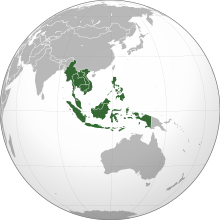
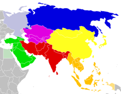
Southeast Asia[a] is the geographical south-eastern region of Asia, consisting of the regions that are situated south of China, east of the Indian subcontinent, and north-west of mainland Australia which is part of Oceania.[5] Southeast Asia is bordered to the north by East Asia, to the west by South Asia and the Bay of Bengal, to the east by Oceania and the Pacific Ocean, and to the south by Australia and the Indian Ocean. Apart from the British Indian Ocean Territory and two out of 26 atolls of Maldives in South Asia, Maritime Southeast Asia is the only other subregion of Asia that lies partly within the Southern Hemisphere. Mainland Southeast Asia is entirely in the Northern Hemisphere. East Timor and the southern portion of Indonesia are the parts of Southeast Asia that lie south of the Equator.
The region lies near the intersection of geological plates, with both heavy seismic and volcanic activities.[6] The Sunda Plate is the main plate of the region, featuring almost all Southeast Asian countries except Myanmar, northern Thailand, northern Laos, northern Vietnam, and northern Luzon of the Philippines, while the Sunda Plate only includes western Indonesia to as far east as the Indonesian province of Bali. The mountain ranges in Myanmar, Thailand, Peninsular Malaysia and the Indonesian islands of Sumatra, Java, Bali, Lesser Sunda Islands, and Timor are part of the Alpide belt, while the islands of the Philippines and Indonesia as well as East Timor are part of the Pacific Ring of Fire. Both seismic belts meet in Indonesia, causing the region to have relatively high occurrences of earthquakes and volcanic eruptions, particularly in the Philippines and Indonesia.[7]
It covers about 4,500,000 km2 (1,700,000 sq mi), which is 8% of Eurasia and 3% of Earth's total land area. Its total population is more than 675 million, about 8.5% of the world's population. It is the third most populous geographical region in Asia after South Asia and East Asia.[8] The region is culturally and ethnically diverse, with hundreds of languages spoken by different ethnic groups.[9] Ten countries in the region are members of the Association of Southeast Asian Nations (ASEAN), a regional organisation established for economic, political, military, educational, and cultural integration among its members.[10]
Southeast Asia is one of the most culturally diverse regions of the world. There are many different languages and ethnicities in the region. Historically, Southeast Asia was significantly influenced by Indian, Chinese, Muslim, and colonial cultures, which became core components of the region's cultural and political institutions. Most modern Southeast Asian countries were colonized by European powers. European colonisation exploited natural resources and labour from the lands they conquered, and attempted to spread European institutions to the region.[11] Several Southeast Asian countries were also briefly occupied by the Japanese Empire during World War II. The aftermath of World War II saw most of the region decolonised. Today, Southeast Asia is predominantly governed by independent states.[12]
Definition

The region, together with part of South Asia, was well known by Europeans as the East Indies or simply the Indies until the 20th century. Chinese sources referred to the region as Nanyang ("南洋"), which literally means the "Southern Ocean". The mainland section of Southeast Asia was referred to as Indochina by European geographers due to its location between China and the Indian subcontinent and its having cultural influences from both neighbouring regions. In the 20th century, however, the term became more restricted to territories of the former French Indochina (Cambodia, Laos, and Vietnam). The maritime section of Southeast Asia is also known as the Malay Archipelago, a term derived from the European concept of a Malay race.[13] Another term for Maritime Southeast Asia is Insulindia (Indian Islands), used to describe the region between Indochina and Australasia.[14]
The term "Southeast Asia" was first used in 1839 by American pastor Howard Malcolm in his book Travels in South-Eastern Asia. Malcolm only included the Mainland section and excluded the Maritime section in his definition of Southeast Asia.[15] The term was officially used in the midst of World War II by the Allies, through the formation of South East Asia Command (SEAC) in 1943.[16] SEAC popularised the use of the term "Southeast Asia", although what constituted Southeast Asia was not fixed; for example, SEAC excluded the Philippines and a large part of Indonesia while including Ceylon. However, by the late 1970s, a roughly standard usage of the term "Southeast Asia" and the territories it encompasses had emerged.[17] Although from a cultural or linguistic perspective the definitions of "Southeast Asia" may vary, the most common definitions nowadays include the area represented by the countries (sovereign states and dependent territories) listed below.
Ten of the eleven states of Southeast Asia are members of the Association of Southeast Asian Nations (ASEAN), while East Timor is an observer state. Papua New Guinea has stated that it might join ASEAN, and is currently an observer. Sovereignty issues exist over some islands in the South China Sea.
Political divisions
Sovereign states
| State | Area (km2) |
Population (2020)[18] |
Density (/km2) |
GDP (nominal), billion USD (2022)[4] |
GDP (PPP), billion Int$ (2022)[4] |
GDP (nominal) per capita, USD (2022)[4] |
GDP (PPP) per capita, Int$ (2022)[4] |
HDI (2021)[19] |
Capital |
|---|---|---|---|---|---|---|---|---|---|
| 5,765[20] | 449,002 | 77 | 16.639 | 31.142 | $37,667 | $70,500 | 0.829 | Bandar Seri Begawan | |
| 181,035[21] | 16,718,965 | 92 | 28.544 | 89.570 | $1,784 | $5,600 | 0.593 | Phnom Penh | |
| 14,874[22] | 1,320,942 | 89 | 3.659 | 7.502 | $2,671 | $5,478 | 0.607 | Dili | |
| 1,904,569[23] | 273,753,191 | 144 | 1,318.807 | 4,036.878 | $4,798 | $14,687 | 0.705 | Jakarta | |
| 236,800[24] | 7,425,057 | 31 | 15.304 | 68.843 | $2,046 | $9,207 | 0.607 | Vientiane | |
| 329,847[25] | 33,573,874 | 102 | 407.923 | 1,134.671 | $12,364 | $34,391 | 0.803 | Kuala Lumpur * | |
| 676,578[26] | 53,798,084 | 80 | 56.757 | 261.170 | $1,053 | $4,846 | 0.585 | Nay Pyi Taw | |
| 300,000[27] | 115,559,009 | 380 | 404.261 | 1,171.162 | $3,623 | $10,497 | 0.699 | Manila | |
| 719.2[28] | 5,921,231 | 8,261 | 466.789 | 719.080 | $82,807 | $127,563 | 0.939 | Singapore | |
| 513,120[29] | 71,601,103 | 140 | 536.160 | 1,482.347 | $7,650 | $21,152 | 0.800 | Bangkok | |
| 331,210[30] | 97,468,029 | 294 | 406.452 | 1,321.249 | $4,086 | $13,283 | 0.703 | Hanoi |
* Administrative centre in Putrajaya.

Geographical divisions
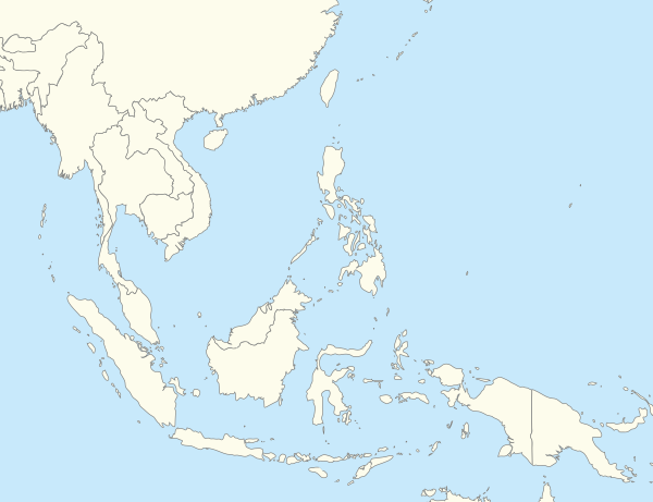
Southeast Asia is geographically divided into two subregions, namely Mainland Southeast Asia (or the Indochinese Peninsula) and Maritime Southeast Asia.
Mainland Southeast Asia includes:
- Cambodia, Laos and Vietnam:
- Myanmar, Thailand and West Malaysia:
Maritime Southeast Asia includes:
While Peninsular Malaysia is geographically situated in Mainland Southeast Asia, it shares many similar cultural and ecological affinities with surrounding islands, thus it is often grouped with them as part of Maritime Southeast Asia.[33] Geographically, the Andaman and Nicobar Islands of India is also considered a part of Maritime Southeast Asia. Eastern Bangladesh and Northeast India have strong cultural ties with Mainland Southeast Asia and are sometimes considered transregional areas between South Asia and Southeast Asia.[34] To the east, Hong Kong is sometimes regarded as part of Southeast Asia.[35][36][37][38][39][40][41] Similarly, Christmas Island and the Cocos (Keeling) Islands have strong cultural ties with Maritime Southeast Asia and are sometimes considered transregional areas between Southeast Asia and Australia/Oceania. On some occasions, Sri Lanka has been considered a part of Southeast Asia because of its cultural and religious ties to Mainland Southeast Asia.[17][42] The eastern half of the island of New Guinea, which is not a part of Indonesia, namely, Papua New Guinea, is sometimes included as a part of Maritime Southeast Asia, and so are Guam, the Northern Mariana Islands, and Palau, which were all parts of the Spanish East Indies with strong cultural and linguistic ties to the region, specifically, the Philippines.[43]
East Timor and the eastern half of Indonesia (east of the Wallace Line in the region of Wallacea) are considered to be geographically associated with Oceania due to their distinctive faunal features. Geologically, the island of New Guinea and its surrounding islands are considered as parts of the Australian continent, connected via the Sahul Shelf. Both Christmas Island and the Cocos (Keeling) Islands are located on the Australian Plate, south of the Sunda Trench. Even though they are geographically closer to Maritime Southeast Asia than mainland Australia, these two Australian external territories are not geologically associated with Asia as none of them is actually on the Sunda Plate. The UN Statistics Division's geoscheme, which is a UN political geography tool created specifically for statistical purposes,[44] has classified both island territories as parts of Oceania, under the UNSD subregion "Australia and New Zealand" (Australasia). Some definitions of Southeast Asia may include Taiwan. Taiwan has sometimes been included in Southeast Asia as well as East Asia but is not a member of ASEAN.[45] Likewise, a similar argument could be applied to some southern parts of mainland China, as well as Hong Kong and Macau, may also considered as part of Southeast Asia as well as East Asia but are not members of ASEAN.[35]
History
Prehistory

The region was already inhabited by Homo erectus from approximately 1,500,000 years ago during the Middle Pleistocene age.[46] Distinct Homo sapiens groups, ancestral to Eastern non-African (related to East Asians as well as Papuans) populations, reached the region by between 50,000BC to 70,000BC, with some arguing earlier.[47][48] Rock art (parietal art) dating from 40,000 years ago (which is currently the world's oldest) has been discovered in the caves of Borneo.[49] Homo floresiensis also lived in the area up until at least 50,000 years ago, after which they became extinct.[50] During much of this time the present-day islands of western Indonesia were joined into a single landmass known as Sundaland due to lower sea levels.
Ancient remains of hunter-gatherers in Maritime Southeast Asia, such as one Holocene hunter-gatherer from South Sulawesi, had ancestry from both the Papuan-related and East Asian-related branches of the Eastern non-African lineage. The hunter-gatherer individual had approximately ~50% "Basal-East Asian" ancestry, and was positioned in between modern East Asians and Papuans of Oceania. The authors concluded that East Asian-related ancestry expanded from Mainland Southeast Asia into Maritime Southeast Asia much earlier than previously suggested, as early as 25,000BC, long before the expansion of Austroasiatic and Austronesian groups.[51]
Distinctive Basal-East Asian (East-Eurasian) ancestry was recently found to have originated in Mainland Southeast Asia at ~50,000BC, and expanded through multiple migration waves southwards and northwards respectively. Geneflow of East Asian-related ancestry into Maritime Southeast Asia and Oceania could be estimated to ~25,000BC (possibly also earlier). The pre-Neolithic Papuan-related populations of Maritime Southeast Asia were largely replaced by the expansion of various East Asian-related populations, beginning about 50,000BC to 25,000BC years ago from Mainland Southeast Asia. The remainders, known as Negritos, form small minority groups in geographically isolated regions. Southeast Asia was dominated by East Asian-related ancestry already in 15,000BC, predating the expansion of Austroasiatic and Austronesian peoples.[48]
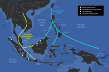
In the late Neolithic, the Austronesian peoples, who form the majority of the modern population in Brunei, Indonesia, East Timor, Malaysia, and the Philippines, migrated to Southeast Asia from Taiwan in the first seaborne human migration known as the Austronesian Expansion. They arrived in the northern Philippines between 7,000 BC to 2,200 BC and rapidly spread further into the Northern Mariana Islands and Borneo by 1500 BC; Island Melanesia by 1300 BC; and to the rest of Indonesia, Malaysia, southern Vietnam, and Palau by 1000 BC.[52][53] They often settled along coastal areas, replacing and assimilating the diverse preexisting peoples.[54][55][48]
The Austronesian peoples of Southeast Asia have been seafarers for thousands of years. They spread eastwards to Micronesia and Polynesia, as well as westwards to Madagascar, becoming the ancestors of modern-day Malagasy people, Micronesians, Melanesians, and Polynesians.[56] Passage through the Indian Ocean aided the colonisation of Madagascar, as well as commerce between Western Asia, eastern coast of India and Chinese southern coast.[56] Gold from Sumatra is thought to have reached as far west as Rome. Pliny the Elder wrote in his Natural History about Chryse and Argyre, two legendary islands rich in gold and silver, located in the Indian Ocean. Their vessels, such as the vinta, were capable to sail across the ocean. Magellan's voyage records how much more manoeuvrable their vessels were, as compared to the European ships.[57] A slave from the Sulu Sea was believed to have been used in Magellan's voyage as a translator.
Studies presented by the Human Genome Organisation (HUGO) through genetic studies of the various peoples of Asia show empirically that there was a single migration event from Africa, whereby the early people travelled along the south coast of Asia, first entered the Malay peninsula 50,000–90,000 years ago. The Orang Asli, in particular the Semang who show Negrito characteristics, are the direct descendants of these earliest settlers of Southeast Asia. These early people diversified and travelled slowly northwards to China, and the populations of Southeast Asia show greater genetic diversity than the younger population of China.[58][59]
Solheim and others have shown evidence for a Nusantao maritime trading network ranging from Vietnam to the rest of the archipelago as early as 5000 BC to 1 AD.[60] The Bronze Age Dong Son culture flourished in Northern Vietnam from about 1000 BC to 1 BC. Its influence spread to other parts Southeast Asia.[61][62][63] The region entered the Iron Age era in 500 BC, when iron was forged also in northern Vietnam still under Dong Son, due to its frequent interactions with neighbouring China.[46]
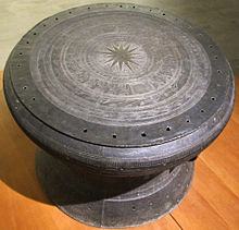
Most Southeast Asian people were originally animist, engaged in ancestors, nature, and spirits worship. These belief systems were later supplanted by Hinduism and Buddhism after the region, especially coastal areas, came under contact with Indian subcontinent during the first century.[64] Indian Brahmins and traders brought Hinduism to the region and made contacts with local courts.[65] Local rulers converted to Hinduism or Buddhism and adopted Indian religious traditions to reinforce their legitimacy, elevate ritual status above their fellow chief counterparts and facilitate trade with South Asian states. They periodically invited Indian Brahmins into their realms and began a gradual process of Indianisation in the region.[66][67][68] Shaivism was the dominant religious tradition of many southern Indian Hindu kingdoms during the first century. It then spread into Southeast Asia via Bay of Bengal, Indochina, then Malay Archipelago, leading to thousands of Shiva temples on the islands of Indonesia as well as Cambodia and Vietnam, co-evolving with Buddhism in the region.[69][70] Theravada Buddhism entered the region during the third century, via maritime trade routes between the region and Sri Lanka.[71] Buddhism later established a strong presence in Funan region in the fifth century. In present-day mainland Southeast Asia, Theravada is still the dominant branch of Buddhism, practised by the Thai, Burmese, and Cambodian Buddhists. This branch was fused with the Hindu-influenced Khmer culture. Mahayana Buddhism established presence in Maritime Southeast Asia, brought by Chinese monks during their transit in the region en route to Nalanda.[66] It is still the dominant branch of Buddhism practised by Indonesian and Malaysian Buddhists.
The spread of these two Indian religions confined the adherents of Southeast Asian indigenous beliefs into remote inland areas. The Maluku Islands and New Guinea were never Indianised and its native people were predominantly animists until the 15th century when Islam began to spread in those areas.[72] While in Vietnam, Buddhism never managed to develop strong institutional networks due to strong Chinese influence.[73] In present-day Southeast Asia, Vietnam is the only country where its folk religion makes up the plurality.[74][75] Recently, Vietnamese folk religion is undergoing a revival with the support of the government.[76] Elsewhere, there are ethnic groups in Southeast Asia that resisted conversion and still retain their original animist beliefs, such as the Dayaks in Kalimantan, the Igorots in Luzon, and the Shans in eastern Myanmar.[77]
Hindu and Buddhist kingdoms era
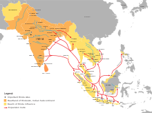
After the region came under contact with the Indian subcontinent c. 400 BCE, it began a gradual process of Indianisation where Indian ideas such as religions, cultures, architectures, and political administrations were brought by traders and religious figures and adopted by local rulers. In turn, Indian Brahmins and monks were invited by local rulers to live in their realms and help transforming local polities to become more Indianised, blending Indian and indigenous traditions.[78][67][68] Sanskrit and Pali became the elite language of the region, which effectively made Southeast Asia part of the Indosphere.[79] Most of the region had been Indianised during the first centuries, while the Philippines later Indianised c. ninth century when Kingdom of Tondo was established in Luzon.[80] Vietnam, especially its northern part, was never fully Indianised due to the many periods of Chinese domination it experienced.[81]
The first Indian-influenced polities established in the region were the Pyu city-states that already existed circa second century BCE, located in inland Myanmar. It served as an overland trading hub between India and China.[82] Theravada Buddhism was the predominant religion of these city states, while the presence of other Indian religions such as Mahayana Buddhism and Hinduism were also widespread.[83][84] In the first century, the Funan states centered in Mekong Delta were established, encompassed modern-day Cambodia, southern Vietnam, Laos, and eastern Thailand. It became the dominant trading power in mainland Southeast Asia for about five centuries, provided passage for Indian and Chinese goods and assumed authority over the flow of commerce through Southeast Asia.[56] In maritime Southeast Asia, the first recorded Indianised kingdom was Salakanagara, established in western Java circa second century CE. This Hindu kingdom was known by the Greeks as Argyre (Land of Silver).[85]

By the fifth century CE, trade networking between East and West was concentrated in the maritime route. Foreign traders were starting to use new routes such as Malacca and Sunda Strait due to the development of maritime Southeast Asia. This change resulted in the decline of Funan, while new maritime powers such as Srivijaya, Tarumanagara, and Mataram emerged. Srivijaya especially became the dominant maritime power for more than 5 centuries, controlling both Strait of Malacca and Sunda Strait.[56] This dominance started to decline when Srivijaya were invaded by Chola Empire, a dominant maritime power of Indian subcontinent, in 1025.[86] The invasion reshaped power and trade in the region, resulted in the rise of new regional powers such as the Khmer Empire and Kahuripan.[87] Continued commercial contacts with the Chinese Empire enabled the Cholas to influence the local cultures. Many of the surviving examples of the Hindu cultural influence found today throughout Southeast Asia are the result of the Chola expeditions.[note 2]
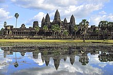
As Srivijaya influence in the region declined, The Hindu Khmer Empire experienced a golden age during the 11th to 13th century CE. The empire's capital Angkor hosts majestic monuments—such as Angkor Wat and Bayon. Satellite imaging has revealed that Angkor, during its peak, was the largest pre-industrial urban centre in the world.[89] The Champa civilisation was located in what is today central Vietnam, and was a highly Indianised Hindu Kingdom. The Vietnamese launched a massive conquest against the Cham people during the 1471 Vietnamese invasion of Champa, ransacking and burning Champa, slaughtering thousands of Cham people, and forcibly assimilating them into Vietnamese culture.[90]
During the 13th century CE, the region experienced Mongol invasions, affected areas such as Vietnamese coast, inland Burma and Java. In 1258, 1285 and 1287, the Mongols tried to invade Đại Việt and Champa.[91] The invasions were unsuccessful, yet both Dai Viet and Champa agreed to become tributary states to Yuan dynasty to avoid further conflicts.[92] The Mongols also invaded Pagan Kingdom in Burma from 1277 to 1287, resulted in fragmentation of the Kingdom and rise of smaller Shan States ruled by local chieftains nominally submitted to Yuan dynasty.[93][94] However, in 1297, a new local power emerged. Myinsaing Kingdom became the real ruler of Central Burma and challenged the Mongol rule. This resulted in the second Mongol invasion of Burma in 1300, which was repulsed by Myinsaing.[95][96] The Mongols would later in 1303 withdrawn from Burma.[97] In 1292, The Mongols sent envoys to Singhasari Kingdom in Java to ask for submission to Mongol rule. Singhasari rejected the proposal and injured the envoys, enraged the Mongols and made them sent a large invasion fleet to Java. Unbeknownst to them, Singhasari collapsed in 1293 due to a revolt by Kadiri, one of its vassals. When the Mongols arrived in Java, a local prince named Raden Wijaya offered his service to assist the Mongols in punishing Kadiri. After Kadiri was defeated, Wijaya turned on his Mongol allies, ambushed their invasion fleet and forced them to immediately leave Java.[98][99]
After the departure of the Mongols, Wijaya established the Majapahit Empire in eastern Java in 1293. Majapahit would soon grow into a regional power. Its greatest ruler was Hayam Wuruk, whose reign from 1350 to 1389 marked the empire's peak when other kingdoms in the southern Malay Peninsula, Borneo, Sumatra, and Bali came under its influence. Various sources such as the Nagarakertagama also mention that its influence spanned over parts of Sulawesi, Maluku, and some areas of western New Guinea and southern Philippines, making it one of the largest empire to ever exist in Southeast Asian history.[100]: 107 By the 15th century CE however, Majapahit's influence began to wane due to many war of successions it experienced and the rise of new Islamic states such as Samudera Pasai and Malacca Sultanate around the strategic Strait of Malacca. Majapahit then collapsed around 1500. It was the last major Hindu kingdom and the last regional power in the region before the arrival of the Europeans.[101][102]
Spread of Islam

Islam began to make contacts with Southeast Asia in the eighth-century CE, when the Umayyads established trade with the region via sea routes.[103][104][105] However its spread into the region happened centuries later. In the 11th century, a turbulent period occurred in the history of Maritime Southeast Asia. The Indian Chola navy crossed the ocean and attacked the Srivijaya kingdom of Sangrama Vijayatungavarman in Kadaram (Kedah); the capital of the powerful maritime kingdom was sacked and the king was taken captive. Along with Kadaram, Pannai in present-day Sumatra and Malaiyur and the Malayan peninsula were attacked too. Soon after that, the king of Kedah Phra Ong Mahawangsa became the first ruler to abandon the traditional Hindu faith, and converted to Islam with the Sultanate of Kedah established in 1136. Samudera Pasai converted to Islam in 1267, the King of Malacca Parameswara married the princess of Pasai, and the son became the first sultan of Malacca. Soon, Malacca became the center of Islamic study and maritime trade, and other rulers followed suit. Indonesian religious leader and Islamic scholar Hamka (1908–1981) wrote in 1961: "The development of Islam in Indonesia and Malaya is intimately related to a Chinese Muslim, Admiral Zheng He."[106]
There are several theories to the Islamization process in Southeast Asia. Another theory is trade. The expansion of trade among West Asia, India and Southeast Asia helped the spread of the religion as Muslim traders from Southern Yemen (Hadramout) brought Islam to the region with their large volume of trade. Many settled in Indonesia, Singapore, and Malaysia. This is evident in the Arab-Indonesian, Arab-Singaporean, and Arab-Malay populations who were at one time very prominent in each of their countries. Finally, the ruling classes embraced Islam and that further aided the permeation of the religion throughout the region. The ruler of the region's most important port, Malacca Sultanate, embraced Islam in the 15th century, heralding a period of accelerated conversion of Islam throughout the region as Islam provided a positive force among the ruling and trading classes. Gujarati Muslims played a pivotal role in establishing Islam in Southeast Asia.[107]
Trade and colonisation

Trade among Southeast Asian countries has a long tradition. The consequences of colonial rule, struggle for independence, and in some cases war influenced the economic attitudes and policies of each country.[108]
Chinese
From 111 BC to 938 AD northern Vietnam was under Chinese rule. Vietnam was successfully governed by a series of Chinese dynasties including the Han, Eastern Han, Eastern Wu, Cao Wei, Jin, Liu Song, Southern Qi, Liang, Sui, Tang, and Southern Han. Records from Magellan's voyage show that Brunei possessed more cannon than European ships, so the Chinese must have been trading with them.[57]
Malaysian legend has it that a Chinese Ming emperor sent a princess, Hang Li Po, to Malacca, with a retinue of 500, to marry Sultan Mansur Shah after the emperor was impressed by the wisdom of the sultan. Hang Li Poh's Well (constructed 1459) is now a tourist attraction there, as is Bukit Cina, where her retinue settled.
The strategic value of the Strait of Malacca, which was controlled by Sultanate of Malacca in the 15th and early 16th century, did not go unnoticed by Portuguese writer Duarte Barbosa, who in 1500 wrote: "He who is lord of Malacca has his hand on the throat of Venice."[This quote needs a citation] (Venice was a major European trading partner, and goods were transported there via the Straight.)
European
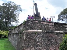
Western influence started to enter in the 16th century, with the arrival of the Portuguese in Malacca, Maluku and the Philippines, the latter being settled by the Spanish years later, which they used to trade between Asia and Latin America. Throughout the 17th and 18th centuries the Dutch established the Dutch East Indies; the French Indochina; and the British Strait Settlements. By the 19th century, all Southeast Asian countries were colonised except for Thailand.
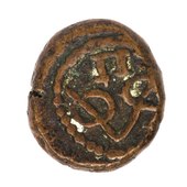
European explorers were reaching Southeast Asia from the west and from the east. Regular trade between the ships sailing east from the Indian Ocean and south from mainland Asia provided goods in return for natural products, such as honey and hornbill beaks from the islands of the archipelago. Before the eighteenth and nineteenth century, the Europeans mostly were interested in expanding trade links. For the majority of the populations in each country, there was comparatively little interaction with Europeans and traditional social routines and relationships continued. For most, a life with subsistence-level agriculture, fishing and, in less developed civilisations, hunting and gathering was still hard.[109]
Zdroj:https://en.wikipedia.org?pojem=Southeast_Asia
Text je dostupný za podmienok Creative Commons Attribution/Share-Alike License 3.0 Unported; prípadne za ďalších podmienok. Podrobnejšie informácie nájdete na stránke Podmienky použitia.
Antropológia
Aplikované vedy
Bibliometria
Dejiny vedy
Encyklopédie
Filozofia vedy
Forenzné vedy
Humanitné vedy
Knižničná veda
Kryogenika
Kryptológia
Kulturológia
Literárna veda
Medzidisciplinárne oblasti
Metódy kvantitatívnej analýzy
Metavedy
Metodika
Text je dostupný za podmienok Creative
Commons Attribution/Share-Alike License 3.0 Unported; prípadne za ďalších
podmienok.
Podrobnejšie informácie nájdete na stránke Podmienky
použitia.
www.astronomia.sk | www.biologia.sk | www.botanika.sk | www.dejiny.sk | www.economy.sk | www.elektrotechnika.sk | www.estetika.sk | www.farmakologia.sk | www.filozofia.sk | Fyzika | www.futurologia.sk | www.genetika.sk | www.chemia.sk | www.lingvistika.sk | www.politologia.sk | www.psychologia.sk | www.sexuologia.sk | www.sociologia.sk | www.veda.sk I www.zoologia.sk

