A | B | C | D | E | F | G | H | CH | I | J | K | L | M | N | O | P | Q | R | S | T | U | V | W | X | Y | Z | 0 | 1 | 2 | 3 | 4 | 5 | 6 | 7 | 8 | 9
Rotsterhaule | |
|---|---|
Village | |
 | |
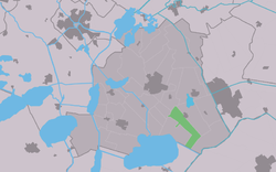
 Location in the former Skarsterlân municipality | |
| Coordinates: 52°55′44″N 5°51′07″E / 52.92889°N 5.85194°E | |
| Country | |
| Province | |
| Municipality | |
| Area | |
| • Total | 9.79 km2 (3.78 sq mi) |
| Elevation | −1.5 m (−4.9 ft) |
| Population (2021)[1] | |
| • Total | 580 |
| • Density | 59/km2 (150/sq mi) |
| Postal code | 8463[1] |
| Dialing code | 0513 |
Rotsterhaule is a village in De Fryske Marren municipality in the province of Friesland, the Netherlands. It had a population of around 565 in 2017.[3]
History
It was first mentioned in 1490 as "op Rotster Haula", and means Haule belonging to Rottum. The etymology of Haule is unclear.[4][5] Rotsterhaule started as a peat excavation project and attracted many people from Overijssel and specifically the Giethoorn region. A chapel has been known to exist since 1490 and was demolished in 1580. In 1840, it was home to 379 people. In 1920, a little church was built which remained in operation until 1982.[6]
Before 2014, Rotsterhaule was part of the Skarsterlân municipality and before 1984 it was part of Haskerland. Before 1934, Rotsterhaule was part of the Schoterland municipality.[6]
References
- ^ a b c "Kerncijfers wijken en buurten 2021". Central Bureau of Statistics. Retrieved 29 March 2022.
- ^ "Postcodetool for 8463ND". Actueel Hoogtebestand Nederland (in Dutch). Het Waterschapshuis. Retrieved 29 March 2022.
- ^ Kerncijfers wijken en buurten 2017 - CBS
- ^ "Rotsterhaule - (geografische naam)". Etymologiebank (in Dutch). Retrieved 29 March 2022.
- ^ "Haule - (geografische naam)". Etymologiebank (in Dutch). Retrieved 29 March 2022.
- ^ a b "Rotsterhaule". Plaatsengids (in Dutch). Retrieved 29 March 2022.
External links
![]() Media related to Rotsterhaule at Wikimedia Commons
Media related to Rotsterhaule at Wikimedia Commons
Text je dostupný za podmienok Creative Commons Attribution/Share-Alike License 3.0 Unported; prípadne za ďalších podmienok. Podrobnejšie informácie nájdete na stránke Podmienky použitia.
Antropológia
Aplikované vedy
Bibliometria
Dejiny vedy
Encyklopédie
Filozofia vedy
Forenzné vedy
Humanitné vedy
Knižničná veda
Kryogenika
Kryptológia
Kulturológia
Literárna veda
Medzidisciplinárne oblasti
Metódy kvantitatívnej analýzy
Metavedy
Metodika
Text je dostupný za podmienok Creative
Commons Attribution/Share-Alike License 3.0 Unported; prípadne za ďalších
podmienok.
Podrobnejšie informácie nájdete na stránke Podmienky
použitia.
www.astronomia.sk | www.biologia.sk | www.botanika.sk | www.dejiny.sk | www.economy.sk | www.elektrotechnika.sk | www.estetika.sk | www.farmakologia.sk | www.filozofia.sk | Fyzika | www.futurologia.sk | www.genetika.sk | www.chemia.sk | www.lingvistika.sk | www.politologia.sk | www.psychologia.sk | www.sexuologia.sk | www.sociologia.sk | www.veda.sk I www.zoologia.sk


