

A | B | C | D | E | F | G | H | CH | I | J | K | L | M | N | O | P | Q | R | S | T | U | V | W | X | Y | Z | 0 | 1 | 2 | 3 | 4 | 5 | 6 | 7 | 8 | 9
Portland, Oregon | |
|---|---|
| Nickname(s): "Rose City"; "Stumptown"; "PDX"; see Nicknames of Portland, Oregon for a complete list. | |
| Motto: "The City that Works" [1] | |
 Interactive map outlining Portland | |
 Portland, Oregon Location in Oregon  Portland, Oregon Location in the United States | |
| Coordinates: 45°31′12″N 122°40′55″W / 45.52000°N 122.68194°W | |
| Country | United States |
| State | Oregon |
| Counties | Multnomah Washington Clackamas |
| Founded | 1845 |
| Incorporated | February 8, 1851 |
| Named for | Portland, Maine[2] |
| Government | |
| • Type | Commission |
| • Mayor | Ted Wheeler[3] (D) |
| • Commissioners | |
| • Auditor | Simone Rede[4] |
| Area | |
| • City | 145.00 sq mi (375.55 km2) |
| • Land | 133.49 sq mi (345.73 km2) |
| • Water | 11.51 sq mi (29.82 km2) |
| • Urban | 519.30 sq mi (1,345.0 km2) |
| Elevation | 161 ft (49 m) |
| Highest elevation | 1,188 ft (362 m) |
| Lowest elevation | 0.62 ft (0.19 m) |
| Population | |
| • City | 652,503 |
| • Rank | 72nd in North America 26th in the United States 1st in Oregon |
| • Density | 4,888.10/sq mi (1,887.30/km2) |
| • Urban | 2,104,238 (US: 23rd) |
| • Urban density | 4,052.1/sq mi (1,564.5/km2) |
| • Metro | 2,511,612 (US: 25th) |
| Demonym | Portlander |
| GDP | |
| • Portland (MSA) | $204.3 billion (2022) |
| Time zone | UTC−08:00 (PST) |
| • Summer (DST) | UTC−07:00 (PDT) |
| ZIP Codes | 97086, 97201-97225, 97227-97233, 97236, 97238-97240, 97242, 97250-97254, 97256, 97266-97269, 97280-97283, 97286, 97290-97294, 97296, 97298, 97214 |
| Area codes | 503 and 971 |
| FIPS code | 41-59000 |
| GNIS feature ID | 2411471[6] |
| Website | www |


.jpg)


Portland (/ˈpɔːrtlənd/ PORT-lənd) is a port city in the Pacific Northwest and the most populous city in the U.S. state of Oregon. Situated in the northwestern area of the state at the confluence of the Willamette and Columbia rivers, it is the county seat of Multnomah County, Oregon's most populous county. As of 2020,[update] Portland's population was 652,503,[12] making it the 26th-most populous city in the United States, the sixth-most populous on the West Coast, and the second-most populous in the Pacific Northwest, after Seattle.[13] Approximately 2.5 million people live in the Portland–Vancouver–Hillsboro, OR–WA metropolitan statistical area, making it the 25th most populous in the United States. About half of Oregon's population resides within the Portland metropolitan area.[a]
Named after Portland, Maine,[14] which is itself named after the English Isle of Portland, the Oregon settlement began to be populated in the 1840s, near the end of the Oregon Trail. Its water access provided convenient transportation of goods, and the timber industry was a major force in the city's early economy. At the turn of the 20th century, the city had a reputation as one of the most dangerous port cities in the world, a hub for organized crime and racketeering. After the city's economy experienced an industrial boom during World War II, its hard-edged reputation began to dissipate. Beginning in the 1960s,[15] it became noted for its growing liberal and progressive political values, earning it a reputation as a bastion of counterculture.[16]
The city operates with a commission-based government, guided by a mayor and four commissioners, as well as Metro, the only directly elected metropolitan planning organization in the United States.[17][18] Its climate is marked by warm, dry summers and cool, rainy winters. This climate is ideal for growing roses, and Portland has been called the "City of Roses" for over a century.[19]
History
Pre-settlement history
During the prehistoric period, the land that would become Portland was flooded after the collapse of glacial dams from Lake Missoula, in what would later become Montana. These massive floods occurred during the last ice age and filled the Willamette Valley with 300 to 400 feet (91 to 122 m) of water.[20]
Before American settlers began arriving in the 1800s, the land was inhabited for many centuries by two bands of indigenous Chinook people – the Multnomah and the Clackamas.[21] The Chinook people occupying the land were first documented in 1805 by Meriwether Lewis and William Clark.[22] Before its European settlement, the Portland Basin of the lower Columbia River and Willamette River valleys had been one of the most densely populated regions on the Pacific Coast.[22]
Establishment


Large numbers of pioneer settlers began arriving in the Willamette Valley in the 1840s via the Oregon Trail, with many arriving in nearby Oregon City.[23] A new settlement then emerged ten miles from the mouth of the Willamette River,[24] roughly halfway between Oregon City and Hudson's Bay Company's Fort Vancouver. This community was initially referred to as "Stumptown" and "The Clearing" because of the many trees cut down to allow for its growth.[25] In 1843 William Overton saw potential in the new settlement but lacked the funds to file an official land claim. For 25 cents, Overton agreed to share half of the 640-acre (2.6 km2) site with Asa Lovejoy of Boston.[26]
In 1844, Overton sold his remaining half of the claim to Francis W. Pettygrove of Portland, Maine. Both Pettygrove and Lovejoy wished to rename "The Clearing" after their respective hometowns (Lovejoy's being Boston, and Pettygrove's, Portland). This controversy was settled with a coin toss that Pettygrove won in a series of two out of three tosses, thereby providing Portland with its namesake.[2] The coin used for this decision, now known as the Portland Penny, is on display in the headquarters of the Oregon Historical Society. At the time of its incorporation on February 8, 1851, Portland had over 800 inhabitants,[27] a steam sawmill, a log cabin hotel, and a newspaper, the Weekly Oregonian. A major fire swept through downtown in August 1873, destroying twenty blocks on the west side of the Willamette along Yamhill and Morrison Streets, and causing $1.3 million in damage,[28] roughly equivalent to $33.1 million today.[29] By 1879, the population had grown to 17,500 and by 1890 it had grown to 46,385.[30] In 1888, the first steel bridge on the West Coast was opened in Portland,[31] the predecessor of the 1912 namesake Steel Bridge that survives today. In 1889, Henry Pittock's wife, Georgiana, established the Portland Rose Society. The movement to make Portland a "Rose City" started as the city was preparing for the 1905 Lewis and Clark Centennial Exposition.[19]
Portland's access to the Pacific Ocean via the Willamette and Columbia rivers, as well as its easy access to the agricultural Tualatin Valley via the "Great Plank Road" (the route of current-day U.S. Route 26), provided the pioneer city with an advantage over other nearby ports, and it grew very quickly.[32] Portland remained the major port in the Pacific Northwest for much of the 19th century, until the 1890s, when Seattle's deepwater harbor was connected to the rest of the mainland by rail, affording an inland route without the treacherous navigation of the Columbia River. The city had its own Japantown,[33] for one, and the lumber industry also became a prominent economic presence, due to the area's large population of Douglas fir, western hemlock, red cedar, and big leaf maple trees.[22]
Portland developed a reputation early in its history as a hard-edged and gritty port town.[34] Some historians have described the city's early establishment as being a "scion of New England; an ends-of-the-earth home for the exiled spawn of the eastern established elite."[35] In 1889, The Oregonian called Portland "the most filthy city in the Northern States", due to the unsanitary sewers and gutters,[36] and, at the turn of the 20th century, it was considered one of the most dangerous port cities in the world.[37] The city housed a large number of saloons, bordellos, gambling dens, and boarding houses which were populated with miners after the California Gold Rush, as well as the multitude of sailors passing through the port.[34] By the early 20th century, the city had lost its reputation as a "sober frontier city" and garnered a reputation for being violent and dangerous.[34][38]
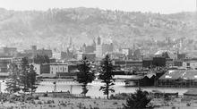
20th-century development

.jpg)
Between 1900 and 1930, the city's population tripled from nearly 100,000 to 301,815.[40] During World War II, it housed an "assembly center" from which up to 3,676 people of Japanese descent were dispatched to internment camps in the heartland. It was the first American city to have residents report thus,[41] and the Pacific International Livestock Exposition operated from May through September 10, 1942, processing people from the city, northern Oregon, and central Washington.[42] General John DeWitt called the city the first "Jap-free city on the West Coast."[41]
At the same time, Portland became a notorious hub for underground criminal activity and organized crime in the 1940s and 1950s.[43] In 1957, Life magazine published an article detailing the city's history of government corruption and crime, specifically its gambling rackets and illegal nightclubs.[43] The article, which focused on crime boss Jim Elkins, became the basis of a fictionalized film titled Portland Exposé (1957). In spite of the city's seedier undercurrent of criminal activity, Portland enjoyed an economic and industrial surge during World War II. Ship builder Henry J. Kaiser had been awarded contracts to build Liberty ships and aircraft carrier escorts, and chose sites in Portland and Vancouver, Washington, for work yards.[44] During this time, Portland's population rose by over 150,000, largely attributed to recruited laborers.[44]
During the 1960s, an influx of hippie subculture began to take root in the city in the wake of San Francisco's burgeoning countercultural scene.[15] The city's Crystal Ballroom became a hub for the city's psychedelic culture, while food cooperatives and listener-funded media and radio stations were established.[45] A large social activist presence evolved during this time as well, specifically concerning Native American rights, environmentalist causes, and gay rights.[45] By the 1970s, Portland had well established itself as a progressive city, and experienced an economic boom for the majority of the decade; however, the slowing of the housing market in 1979 caused demand for the city and state timber industries to drop significantly.[46]
Since 1990

In the 1990s, the technology industry began to emerge in Portland, specifically with the establishment of companies such as Intel, which brought more than US$10 billion in investments in 1995 alone.[47] In the late 1990s, the Portland area was rated the fourth-least affordable place in the United States to purchase a new home.[48] After 2000, Portland experienced significant growth, with a population rise of over 90,000 between the years 2000 and 2014.[49] The city's increasing reputation for culture established it as a popular city for young people, and it was second only to Louisville, Kentucky as one of the cities to attract and retain the highest number of college-educated people in the United States.[50] Between 2001 and 2012, Portland's gross domestic product per person grew by fifty percent, more than any other city in the country.[50]
The city acquired a diverse range of nicknames throughout its history, though it is most often called "Rose City" or "The City of Roses"[51] (unofficial nickname since 1888, official since 2003).[52] Another widely used nickname by local residents in everyday speech is "PDX", the airport code for Portland International Airport. Other nicknames include Bridgetown,[53] Stumptown,[54] Rip City,[55] Soccer City,[56][57] P-Town,[52][58] Portlandia, and the more antiquated Little Beirut.[59]
2020 George Floyd protests

From May 28, 2020, until spring 2021,[60] there were daily protests about the murder of George Floyd by police, and racial injustice. There were instances of looting, vandalism, and police actions causing injuries. One protestor was killed by an opposing one.[61][62][63][64] Local businesses reported losses totaling millions of dollars as the result of vandalism and looting, according to Oregon Public Broadcasting.[65] Some protests caused injury to protesters and police. In July, federal officers were deployed to safeguard federal property; their presence and tactics were criticized by Oregon officials, who demanded they leave, while lawsuits were filed against local and federal law enforcement alleging wrongful actions by them.[66][67][68][69]
On May 25, 2021, a protest to commemorate the one-year anniversary of Floyd's murder caused property damage, and was followed by a number of arrests.[70][71]
Geography
Geology
Portland lies on top of a dormant volcanic field known as the Boring Lava Field, named after the nearby bedroom community of Boring.[72] The Boring Lava Field has at least 32 cinder cones such as Mount Tabor,[73] and its center lies in southeast Portland. Mount St. Helens, a highly active volcano 50 miles (80 km) northeast of the city in Washington state, is easily visible on clear days and is close enough to have dusted the city with volcanic ash after its eruption on May 18, 1980.[74] The rocks of the Portland area range in age from late Eocene to more recent eras.[75]
Multiple shallow, active fault lines traverse the Portland metropolitan area.[76] Among them are the Portland Hills Fault on the city's west side,[77] and the East Bank Fault on the east side.[78] According to a 2017 survey, several of these faults were characterized as "probably more of a hazard" than the Cascadia subduction zone due to their proximities to population centers, with the potential of producing magnitude 7 earthquakes.[76] Notable earthquakes that have impacted the Portland area in recent history include the 6.8-magnitude Nisqually earthquake in 2001, and a 5.6-magnitude earthquake that struck on March 25, 1993.[79][80]
Per a 2014 report, over 7,000 locations within the Portland area are at high risk for landslides and soil liquefaction in the event of a major earthquake, including much of the city's west side (such as Washington Park) and sections of Clackamas County.[81]
Topography
Portland is 60 miles (97 km) east of the Pacific Ocean at the northern end of Oregon's most populated region, the Willamette Valley. Downtown Portland straddles the banks of the Willamette River, which flows north through the city center and separates the city's east and west neighborhoods. Less than 10 miles (16 km) from downtown, the Willamette River flows into the Columbia River, the fourth-largest river in the United States, which divides Oregon from Washington state. Portland is approximately 100 miles (160 km) upriver from the Pacific Ocean on the Columbia.
Though much of downtown Portland is relatively flat, the foothills of the Tualatin Mountains, more commonly referred to locally as the "West Hills", pierce through the northwest and southwest reaches of the city. Council Crest Park at 1,073 feet (327 m) is often quoted as the highest point in Portland; however, the highest point in Portland is on a section of NW Skyline Blvd just north of Willamette Stone Heritage site.[82] The highest point east of the river is Mt. Tabor, an extinct volcanic cinder cone, which rises to 636 feet (194 m). Nearby Powell Butte and Rocky Butte rise to 614 feet (187 m) and 612 feet (187 m), respectively. To the west of the Tualatin Mountains lies the Oregon Coast Range, and to the east lies the actively volcanic Cascade Range. On clear days, Mt. Hood and Mt. St. Helens dominate the horizon, while Mt. Adams and Mt. Rainier can also be seen in the distance.
According to the United States Census Bureau, the city has an area of 145.09 square miles (375.78 km2), of which 133.43 square miles (345.58 km2) is land and 11.66 square miles (30.20 km2) is water.[83] Although almost all of Portland is within Multnomah County, small portions of the city are within Clackamas and Washington Counties, with populations estimated at 785 and 1,455, respectively.[citation needed]
Climate
_-_Portland_Area,_OR(ThreadEx).svg)
Portland has a warm-summer Mediterranean climate (Köppen Csb), falling just short of a hot-summer Mediterranean climate (Köppen Csa) with cool and rainy winters, and warm and dry summers.[84] This climate is characterized by having overcast, wet, and changing weather conditions in fall, winter, and spring, as Portland lies in the direct path of the stormy westerly flow, and warm, dry summers when the North Pacific High reaches its northernmost point in mid-summer.[85] Portland's USDA Plant Hardiness Zone is 8b, with parts of the Downtown area falling into zone 9a.[86]
Winters are cool, cloudy, and rainy. The coldest month is December with an average daily high temperature of 46.9 °F (8.3 °C), although overnight lows usually remain above freezing by a few degrees. Evening temperatures fall to or below freezing 32 nights per year on average, but very rarely below 18 °F (−8 °C). There are only 2.1 days per year where the daytime high temperature fails to rise above freezing; the mean for the coldest high is at the exact freezing point of 32 °F (0 °C).[87] The lowest overnight temperature ever recorded was −3 °F (−19 °C),[86] on February 2, 1950,[87] while the coldest daytime high temperature ever recorded was 14 °F (−10 °C) on December 30, 1968.[87] The average window in which freezing temperatures may occur is between November 15 and March 19, allowing a growing season of 240 days.[87]
Annual snowfall in Portland is 4.3 inches (10.9 cm), which usually falls between December and March.[88] The city of Portland avoids snow more frequently than its suburbs, due in part to its low elevation and the urban heat island effect. Neighborhoods outside of the downtown core, especially in slightly higher elevations near the West Hills and Mount Tabor, can experience a dusting of snow while downtown receives no accumulation at all. The city has experienced a few major snow and ice storms in its past, with extreme totals having reached 44.5 in (113 cm) at the airport in 1949–50 and 60.9 in (155 cm) at downtown in 1892–93.[89][90]

Summers in Portland are warm, dry, and sunny, though the sunny warm weather is short-lived, from mid-June to early September.[91] June, July, August and September account for a combined 4.19 inches (106 mm) of total rainfall – only 11% of the 36.91 in (938 mm) of annual precipitation. The warmest month is August, with an average high temperature of 82.3 °F (27.9 °C). Because of its inland location 62 miles (100 km) from the coast, as well as the protective nature of the Oregon Coast Range to its west, Portland summers are less susceptible to the moderating influence of the nearby Pacific Ocean. Consequently, Portland occasionally experiences heat waves, with temperatures rising above 90 °F (32 °C) for a few days. However, on average, temperatures reach or exceed 80 °F (27 °C) on only 61 days per year, of which 15 days will reach 90 °F (32 °C) and only 1.3 days will reach 100 °F (38 °C). In 2018 more 90-degree days were recorded than ever before.[92]
On June 28, 2021, Portland recorded its all-time record high temperature of 116 °F (47 °C) and its warmest daily low temperature of 75 °F (24 °C) during a major regional heat wave.[93] The record had been broken for three consecutive days with daytime highs of 108 °F (42 °C) on June 26 and 112 °F (44 °C) on June 27; the previous record of 107 °F (42 °C) was set in July 1965 and matched twice in August 1981.[94][95] A temperature of 100 °F (38 °C) has been recorded in all five months from May through September. The warmest night of the year averages 68 °F (20 °C).[87]
Spring and fall can bring variable weather including high-pressure ridging that sends temperatures surging above 80 °F (27 °C) and cold fronts that plunge daytime temperatures into the 40s °F (4–9 °C). However, lengthy stretches of overcast days beginning in mid-fall and continuing into mid-spring are most common. Rain often falls as a light drizzle for several consecutive days at a time, contributing to 157 days on average with measurable (≥0.01 in or 0.25 mm) precipitation annually. Temperatures have reached 90 °F (32 °C) as early as April 30 and as late as October 5, while 80 °F (27 °C) has been reached as early as April 1 and as late as October 21. Thunderstorms are uncommon and tornadoes are very rare, although they do occur.[96][97]
| Climate data for Portland, Oregon (PDX), 1991–2020 normals,[b] extremes 1940–present[c][99] | |||||||||||||
|---|---|---|---|---|---|---|---|---|---|---|---|---|---|
| Month | Jan | Feb | Mar | Apr | May | Jun | Jul | Aug | Sep | Oct | Nov | Dec | Year |
| Record high °F (°C) | 66 (19) |
71 (22) |
80 (27) |
90 (32) |
100 (38) |
116 (47) |
107 (42) |
108 (42) |
105 (41) |
92 (33) |
73 (23) |
67 (19) |
116 (47) |
| Mean maximum °F (°C) | 58.1 (14.5) |
60.1 (15.6) |
69.6 (20.9) |
78.4 (25.8) |
86.9 (30.5) |
91.7 (33.2) |
96.6 (35.9) |
96.7 (35.9) |
91.2 (32.9) |
77.6 (25.3) |
63.8 (17.7) |
58.3 (14.6) |
99.9 (37.7) |
| Mean daily maximum °F (°C) | 47.5 (8.6) |
51.5 (10.8) |
56.8 (13.8) |
62.0 (16.7) |
69.3 (20.7) |
74.3 (23.5) |
81.9 (27.7) |
82.3 (27.9) |
76.7 (24.8) |
64.4 (18.0) |
53.5 (11.9) |
46.9 (8.3) |
63.9 (17.7) |
| Daily mean °F (°C) | 41.9 (5.5) |
44.1 (6.7) |
48.3 (9.1) |
52.8 (11.6) |
59.4 (15.2) |
64.2 (17.9) |
70.2 (21.2) |
70.6 (21.4) |
65.4 (18.6) |
55.6 (13.1) |
47.1 (8.4) |
41.6 (5.3) |
55.1 (12.8) |
| Mean daily minimum °F (°C) | 36.2 (2.3) |
36.8 (2.7) |
39.7 (4.3) |
43.7 (6.5) |
49.4 (9.7) |
54.1 (12.3) |
58.5 (14.7) |
58.9 (14.9) |
54.1 (12.3) |
46.7 (8.2) |
40.6 (4.8) |
36.2 (2.3) |
46.2 (7.9) |
| Mean minimum °F (°C) | 25.1 (−3.8) |
25.9 (−3.4) |
30.4 (−0.9) |
34.8 (1.6) |
40.5 (4.7) |
47.3 (8.5) |
52.3 (11.3) |
51.8 (11.0) |
45.7 (7.6) |
36.0 (2.2) |
29.2 (−1.6) |
24.9 (−3.9) |
20.8 (−6.2) |
| Record low °F (°C) | −2 (−19) |
−3 (−19) |
19 (−7) |
29 (−2) |
29 (−2) |
39 (4) |
43 (6) |
44 (7) |
34 (1) |
26 (−3) |
13 (−11) |
6 (−14) |
−3 (−19) |
| Average precipitation inches (mm) | 5.03 (128) |
3.68 (93) |
3.97 (101) |
2.89 (73) |
2.51 (64) |
1.63 (41) |
0.51 (13) Zdroj:https://en.wikipedia.org?pojem=Portland,_Oregon Text je dostupný za podmienok Creative Commons Attribution/Share-Alike License 3.0 Unported; prípadne za ďalších podmienok. Podrobnejšie informácie nájdete na stránke Podmienky použitia.
Analytika
Antropológia Aplikované vedy Bibliometria Dejiny vedy Encyklopédie Filozofia vedy Forenzné vedy Humanitné vedy Knižničná veda Kryogenika Kryptológia Kulturológia Literárna veda Medzidisciplinárne oblasti Metódy kvantitatívnej analýzy Metavedy Metodika Text je dostupný za podmienok Creative
Commons Attribution/Share-Alike License 3.0 Unported; prípadne za ďalších
podmienok. www.astronomia.sk | www.biologia.sk | www.botanika.sk | www.dejiny.sk | www.economy.sk | www.elektrotechnika.sk | www.estetika.sk | www.farmakologia.sk | www.filozofia.sk | Fyzika | www.futurologia.sk | www.genetika.sk | www.chemia.sk | www.lingvistika.sk | www.politologia.sk | www.psychologia.sk | www.sexuologia.sk | www.sociologia.sk | www.veda.sk I www.zoologia.sk | ||||||