

A | B | C | D | E | F | G | H | CH | I | J | K | L | M | N | O | P | Q | R | S | T | U | V | W | X | Y | Z | 0 | 1 | 2 | 3 | 4 | 5 | 6 | 7 | 8 | 9
Masterton
Whakaoriori (Māori) | |
|---|---|
 | |
 Location of Masterton District in North Island | |
| Coordinates: 40°58′S 175°39′E / 40.97°S 175.65°E | |
| Country | New Zealand |
| Region | Greater Wellington |
| District | Masterton District |
| Town founded | 1854 |
| NZ Parliament | Ikaroa-Rāwhiti (Māori) Wairarapa |
| Government | |
| • Mayor | Gary Caffell |
| • Deputy Mayor | Bex Johnson |
| • MPs | Mike Butterick (National) Cushla Tangaere-Manuel (Labour) |
| • Territorial authority | Masterton District Council |
| Area | |
| • Territorial | 2,300.17 km2 (888.10 sq mi) |
| • Urban | 22.45 km2 (8.67 sq mi) |
| Elevation | 69 m (420 ft) |
| Population (June 2023)[2] | |
| • Territorial | 29,100 |
| • Density | 13/km2 (33/sq mi) |
| • Urban | 22,600 |
| • Urban density | 1,000/km2 (2,600/sq mi) |
| Time zone | UTC+12 (NZST) |
| • Summer (DST) | UTC+13 (NZDT) |
| Postcode | 5810 |
| Area code | 06 |
| Website | www |
Masterton (Māori: Whakaoriori)[3] is a large town in the Greater Wellington Region of New Zealand that operates as the seat of the Masterton District (a territorial authority or local-government district). It is the largest town in the Wairarapa, a region separated from Wellington by the Remutaka ranges. It stands on the Waipoua stream between the Ruamāhunga and Waingawa Rivers – 100 kilometres north-east of Wellington and 39.4 kilometres south of Eketāhuna.
Masterton has an urban population of 22,600, and a district population of 29,100 (June 2023).[2]
Masterton businesses includes services for surrounding farmers. Three new industrial parks are being developed[when?] in Waingawa, Solway and Upper Plain. The town functions as the headquarters of the annual Golden Shears sheep-shearing competition.
Suburbs
Masterton suburbs include:
- Lansdowne, Te Ore Ore on the northern side
- Eastside and Homebush on the eastern side
- Upper Plain, Fernridge, Ngaumutawa, Ākura and Masterton West on the western side
- Kuripuni and Solway on the southern side
History and culture
Early history
Masterton was founded in 1854 by the Small Farms Association. The association was led by Joseph Masters – after whom the town was named – and aimed to settle working people in villages and on the land. At first Masterton grew slowly, but as its farming hinterland became more productive it began to prosper.
In the 1870s, it overtook Greytown as Wairarapa's major town. It became a borough in 1877 and was reached by the railway line from Wellington in 1880. The railway became for a time the main line from Wellington to the north of New Zealand, and its arrival cemented the town's position as the Wairarapa region's main market and distribution centre.
Waipoua timber mill was producing butter boxes as early as 1884.[4]
In April 1965, one of the country's worst industrial accidents occurred at the General Plastics Factory on 170 Dixon Street.[5]
During World War II two battalions of the United States Marine Corps were stationed in Masterton.[6]
-
 The railway station opened 1880, demolished 1967
 -
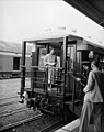 Railway station, 15 January 1954
 -
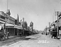 Queen Street in the early 1900s
 -
 The Post Office opened 1900, demolished 1960
 -
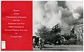 4 killed in the General Plastics Explosion and Fire 1965
.jpg)
.jpg)
_(cropped).jpg)
.jpg)
_Ltd._Explosion_and_Fire_(1965)_(26271497746).jpg)
Modern history
In essence, providing support services for rural industry – living off the sheep's back – Masterton's real growth ended with that sector's retrenchment after the 1974 British entry to the trade and political grouping now the European Union. Efforts to decentralise industry to New Zealand's provinces gave Masterton a print works and some other industries, but the lost economic activity was not restored.
From the 1970s, people and businesses left for opportunities elsewhere. In the 1980s, with government deregulation and protective tariffs lifted, more businesses closed, and the town declined further.[7]
It did not quite qualify to be a city by 1989 when the minimum population requirement for that status was lifted from 20,000 to 50,000.
Marae
Te Oreore marae and Ngā Tau e Waru meeting house, located in Masterton, is affiliated with the iwi of Ngāti Kahungunu and its hapū of Kahukuraawhitia, Kahukuranui, Ngāti Te Hina, Tahu o Kahungunu, Tamahau and Whiunga, and with the iwi of Rangitāne, and its hapū of Hinetearorangi, Ngāi Tamahau, Ngāti Hāmua, Ngāti Taimahu, Ngāti Tangatakau, Ngāti Te Noti, Ngāti Te Raetea and Ngāti Te Whātui.
In October 2020, the Government committed $2,179,654 from the Provincial Growth Fund to upgrade Ngāi Tumapuhia a Rangi ki Okautete, Motuwairaka, Pāpāwai, Kohunui, Hurunui o Rangi and Te Oreore marae. The projects were expected to create 19.8 full time jobs.[8]
Another local marae, Ākura Marae, is affiliated with the Ngāti Kahungunu hapū of Ngāti Te Ahuahu and Ngāti Te Hina. and with the Rangitāne hapū of Ngāti Mātangiuru and Ngāti Te Hina.[9][10]
Demographics

Masterton District covers 2,300.17 km2 (888.10 sq mi)[1] and had an estimated population of 29,100 as of June 2023,[2] with a population density of 13 people per km2. The Masterton urban area covers 22.45 km2 (8.67 sq mi)[1] and had an estimated population of 22,600 as of June 2023,[2] with a population density of 1,007 people per km2.
| Year | Pop. | ±% p.a. |
|---|---|---|
| 1891 | 3,114 | — |
| 1896 | 3,493 | +2.32% |
| 1901 | 3,949 | +2.48% |
| 1906 | 3,723 | −1.17% |
| 1911 | 5,182 | +6.84% |
| 1916 | 5,560 | +1.42% |
| 1921 | 7,820 | +7.06% |
| 1926 | 8,575 | +1.86% |
| 1936 | 8,950 | +0.43% |
| 1945 | 9,480 | +0.64% |
| 1951 | 11,545 | +3.34% |
| 1956 | 13,000 | +2.40% |
| 1961 | 16,944 | +5.44% |
| 1966 | 19,116 | +2.44% |
| 1971 | 20,194 | +1.10% |
| 1976 | 19,460 | −0.74% |
| 1981 | 18,545 | −0.96% |
| 1986 | 20,145 | +1.67% |
| 1991 | 22,566 | +2.30% |
| 1996 | 22,755 | +0.17% |
| 2001 | 22,614 | −0.12% |
| 2006 | 22,623 | +0.01% |
| 2013 | 23,352 | +0.45% |
| 2018 | 25,557 | +1.82% |
| Source: [11] | ||
Masterton District had a population of 25,557 at the 2018 New Zealand census, an increase of 2,205 people (9.4%) since the 2013 census, and an increase of 2,934 people (13.0%) since the 2006 census. There were 9,936 households, comprising 12,372 males and 13,185 females, giving a sex ratio of 0.94 males per female. The median age was 43.2 years (compared with 37.4 years nationally), with 4,968 people (19.4%) aged under 15 years, 4,371 (17.1%) aged 15 to 29, 10,857 (42.5%) aged 30 to 64, and 5,361 (21.0%) aged 65 or older.
Ethnicities were 84.7% European/Pākehā, 21.3% Māori, 4.0% Pasifika, 3.9% Asian, and 1.6% other ethnicities. People may identify with more than one ethnicity.
The percentage of people born overseas was 12.9, compared with 27.1% nationally.
Although some people chose not to answer the census's question about religious affiliation, 50.2% had no religion, 37.7% were Christian, 1.2% had Māori religious beliefs, 0.7% were Hindu, 0.1% were Muslim, 0.4% were Buddhist and 1.8% had other religions.
Of those at least 15 years old, 3,030 (14.7%) people had a bachelor's or higher degree, and 4,803 (23.3%) people had no formal qualifications. The median income was $27,800, compared with $31,800 nationally. 2,403 people (11.7%) earned over $70,000 compared to 17.2% nationally. The employment status of those at least 15 was that 9,420 (45.8%) people were employed full-time, 3,270 (15.9%) were part-time, and 705 (3.4%) were unemployed.[11]
| SA2 name | Population | Dwellings | Median age | Median income |
|---|---|---|---|---|
| Cameron and Soldiers Park | 2,160 | 963 | 43.3 years | $24,200 |
| Douglas Park | 2,016 | 873 | 44.7 years | $26,000 |
| Kuripuni | 1,653 | 687 | 45.7 years | $26,200 |
| Lansdowne East | 2,715 | 1,158 | 47.2 years | $27,200 |
| Lansdowne West | 1,596 | 696 | 44.5 years | $28,200 |
| Masterton Central | 711 | 297 | 40.7 years | $23,700 |
| McJorrow Park | 1,677 | 588 | 30.0 years | $20,300 |
| Ngaumutawa | 1,491 | 684 | 46.6 years | $27,200 |
| Solway North | 2,346 | 963 | 40.0 years | $26,700 |
| Solway South | 3,459 | 1,401 | 37.9 years | $27,600 |
| Homebush-Te Ore Ore | 1,050 | 432 | 49.0 years | $36,500 |
| Kopuaranga | 915 | 405 | 45.3 years | $35,400 |
| Opaki | 1,140 | 459 | 49.4 years | $42,000 |
| Upper Plain | 1,224 | 480 | 46.9 years | $35,600 |
| Whareama | 1,410 | 1,296 | 43.6 years | $34,000 |
Climate
Masterton enjoys a mild temperate climate (Köppen: Cfb), grading towards a Mediterranean climate (Köppen: Csb). Due to the geography of the Wairarapa valley and the Tararua Range directly to the west, the town's temperature fluctuates more than the nearby inland city of Palmerston North. Masterton experiences warmer, dry summers with highs above 30 °C possible and colder winters with frequent frost and lows below 0 °C.
| Climate data for Masterton | |||||||||||||
|---|---|---|---|---|---|---|---|---|---|---|---|---|---|
| Month | Jan | Feb | Mar | Apr | May | Jun | Jul | Aug | Sep | Oct | Nov | Dec | Year |
| Mean daily maximum °C (°F) | 24.3 (75.7) |
24.0 (75.2) |
21.9 (71.4) |
18.8 (65.8) |
15.4 (59.7) |
13.2 (55.8) |
12.1 (53.8) |
13.1 (55.6) |
15.4 (59.7) |
17.5 (63.5) |
19.8 (67.6) |
22.1 (71.8) |
18.1 (64.6) |
| Daily mean °C (°F) | 18.1 (64.6) |
17.7 (63.9) |
16.3 (61.3) |
13.1 (55.6) |
10.5 (50.9) |
8.6 (47.5) |
7.6 (45.7) |
8.4 (47.1) |
10.5 (50.9) |
12.3 (54.1) |
14.2 (57.6) |
16.4 (61.5) |
12.8 (55.0) |
| Mean daily minimum °C (°F) | 11.8 (53.2) |
11.4 (52.5) |
10.6 (51.1) |
7.5 (45.5) |
5.5 (41.9) |
4.0 (39.2) |
3.1 (37.6) |
3.7 (38.7) |
5.6 (42.1) |
7.1 (44.8) |
8.7 (47.7) |
10.7 (51.3) |
7.5 (45.5) |
| Average rainfall mm (inches) | 44.4 (1.75) |
68.9 (2.71) |
84.5 (3.33) |
54.0 (2.13) |
93.6 (3.69) |
105.3 (4.15) |
90.9 (3.58) |
86.7 (3.41) |
73.7 (2.90) |
77.2 (3.04) |
77.5 (3.05) |
70.9 (2.79) |
922.9 (36.33) |
| Average rainy days | 7.1 | 7.6 | 10.1 | 9.2 | 11.0 | 13.2 | 14.1 | 14.1 | 11.7 | 12.8 | 10.0 | 9.7 | 129.8 |
| Average relative humidity (%) | 76.0 | 82.9 | 84.2 | 87.0 | 89.5 | 91.3 | 91.1 | 89.6 | 83.5 | 79.0 | 78.8 | 76.9 | 84.2 |
| Mean monthly sunshine hours | 238.6 | 204.4 | 169.2 | 155.6 | 132.0 | 99.9 | 114.9 | 128.6 | 148.0 | 184.0 | 185.6 | 221.3 | 1,964.2 |
| Source: NIWA Climate Data[13] | |||||||||||||
Government

Between 1877 and 1989, Masterton Borough Council administered the area. An early mayor was the storekeeper Myer Caselberg (1886–1888).[14]
The Masterton District Council (MDC) is the Masterton District territorial authority. It is made up of an elected mayor, a deputy mayor/councillor, and seven additional councillors. They are elected under the First Past the Post system in triennial elections, with the last election being held on Saturday 15 October 2022.[15]
The current council members are:[16] Gary Caffell (M), general ward; Bex Johnson (DM), Tom Hullena, Tim Nelson, Craig Bowyer, at large; David Holmes, Stella Lennox, Brent Goodwin, Māori ward; Marama Tuuta.
Nationally, Masterton is part of the Wairarapa general electorate and the Ikaroa-Rāwhiti Māori electorate.[17]
Zdroj:https://en.wikipedia.org?pojem=MastertonText je dostupný za podmienok Creative Commons Attribution/Share-Alike License 3.0 Unported; prípadne za ďalších podmienok. Podrobnejšie informácie nájdete na stránke Podmienky použitia.
Antropológia
Aplikované vedy
Bibliometria
Dejiny vedy
Encyklopédie
Filozofia vedy
Forenzné vedy
Humanitné vedy
Knižničná veda
Kryogenika
Kryptológia
Kulturológia
Literárna veda
Medzidisciplinárne oblasti
Metódy kvantitatívnej analýzy
Metavedy
Metodika
Text je dostupný za podmienok Creative
Commons Attribution/Share-Alike License 3.0 Unported; prípadne za ďalších
podmienok.
Podrobnejšie informácie nájdete na stránke Podmienky
použitia.
www.astronomia.sk | www.biologia.sk | www.botanika.sk | www.dejiny.sk | www.economy.sk | www.elektrotechnika.sk | www.estetika.sk | www.farmakologia.sk | www.filozofia.sk | Fyzika | www.futurologia.sk | www.genetika.sk | www.chemia.sk | www.lingvistika.sk | www.politologia.sk | www.psychologia.sk | www.sexuologia.sk | www.sociologia.sk | www.veda.sk I www.zoologia.sk