

A | B | C | D | E | F | G | H | CH | I | J | K | L | M | N | O | P | Q | R | S | T | U | V | W | X | Y | Z | 0 | 1 | 2 | 3 | 4 | 5 | 6 | 7 | 8 | 9
Kawasaki
川崎市 | |
|---|---|
| Kawasaki City | |
 Kawasaki Daishi, Tama River, Lazona Kawasaki Plaza, Musashi-Kosugi area, Todoroki Athletics Stadium, Keihin industrial area | |
 Flag  Seal | |
 | |
 Location of Kawasaki in Kanagawa Prefecture | |
 Kawasaki | |
| Coordinates: 35°31′N 139°42′E / 35.517°N 139.700°E | |
| Country | Japan |
| Region | Kantō |
| Prefecture | Kanagawa Prefecture |
| First official recorded | late 4th century |
| City Settled | July 1, 1924 |
| Government | |
| • Mayor | Norihiko Fukuda |
| Area | |
| • Total | 143.01 km2 (55.22 sq mi) |
| Population (January 1, 2020) | |
| • Total | 1,531,646 |
| • Density | 11,000/km2 (28,000/sq mi) |
| Time zone | UTC+9 (Japan Standard Time) |
| - Tree | Camellia |
| - Flower | Azalea |
| Phone number | 044-200-2111 |
| Address | 1 Miyamoto-chō, Kawasaki-ku, Kawasaki-shi, Kanagawa-ken 210-8577 |
| Website | www |
Kawasaki (川崎市, Kawasaki-shi), [kawasaki] ; is a city in Kanagawa Prefecture, Japan, one of the main cities of the Greater Tokyo Area and Keihin Industrial Area. It is the second most populated city in Kanagawa Prefecture after Yokohama, and the eighth most populated city in Japan (including the Tokyo Metropolitan Area).[1]
As of October 1, 2017[update], the city has an estimated population of 1,503,690, with 716,470 households,[1] and a population density of 10,000 persons per km2. Kawasaki is the only city in Japan with more than one million inhabitants that is not a prefectural capital. The total area is 142.70 km2 (55.10 sq mi).
History
Prehistoric and Ancient era
Archaeological evidence from the Japanese Paleolithic and Jōmon period can only be found in the northwest Tama Hills. The course of the Tama and the coast of the Bay of Tokyo have also changed in historical times, so that large parts of the urban area are geologically young.
Classical era
Nara period to the Sengoku period
With the introduction of the Ritsuryō legal system, the area came to the Musashi Province in the 7th century. In the Nara period, the center of the Tachibana district was probably in the area of today's Takatsu district. Since the Heian period, the domain of the Inage clan has expanded here. Around the Heiken-ji Buddhist temple (better known as Kawasaki-Daishi), founded in 1128, a monzen-machi, a busy district for the supply of pilgrims, soon emerged. Between the Kamakura period and Sengoku period, smaller feudal lords ruled the area until it finally came under the control of the Later Hōjō clan.
Early Modern
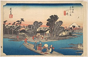
In 1611, Koizumi Jidayū had Nikaryō Yōsui built, a canal system on the right bank of the Tama for irrigating the fields, which in some cases still runs through the densely built-up city. On the long-distance Kaidō roads Tōkaidō and Nakaharakaidō built by Edo-Bakufu, stations were built in the area of what would later become Kawasaki, which increased its importance. The Kawasaki station (Kawasaki-juku, near today's Kawasaki station) on the Tōkaidō was not officially recognized until 1623 as the last of the 53 Tōkaidō stations. The Bakufu let the bridges over the Tama collapse and there were ferry connections to nearby Edo in several places in today's Kawasaki, which laid the foundation for the development of the city.
- Gallery
-
 Old building in the "Kura-zukuri" style on Oyama Kaido street
 -
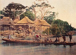 Rokugō no Watashi in the 1860s photographed by Felice Beato
 -
 Ferry Boat Crossing the Rokugo River


Modern
The rapid urbanization of the area, which continues to this day, began in the Meiji and Taishō eras. In 1872, Kawasaki Station was established on the Tōkaidō Main Line which was Japan's first railway line.[2] In 1889, the city (machi) Kawasaki in the district (gun) Tachibana was created according to the Japanese municipal system introduced the year before. In 1912 the border between Kanagawa and Tokyo prefectures was established as the Tama River. On July 1, 1924, the independent city (shi-) of Kawasaki with 48,394 inhabitants was formed through a merger with the city of Daishi (formerly Daishigawara) and the village of Miyuki.[3]
People from the Korean peninsula were made to work in the industrial sector in the city,[4] working on railways construction, or rebuilding roads damaged by U.S. bombings towards the end of WWII.[5] People from Okinawa were also coming to the city, and in 1924, the oldest Okinawans Association in Japan was founded in Kawasaki.[6][7]
World War II
As part of World War II, the city was bombed three times by the United States Army Air Forces (USAAF) between April 1945 and July 1945. The most serious attack was an area bombing with Napalm bombs on April 15, 1945. The attacks destroyed around 35% of the urban area and claimed 1,520 dead and 8,759 injured. The attacks burned down 9.3 km2 of the city (see Bombing of Tokyo).[citation needed] Kawasaki became a target of the first mainland bombing by the US military in 1942, followed by multiple bombings, partly due to the city's heavy and chemical industrial complex supplying the war efforts in Asia and the Pacific.[8]
Contemporary period
Shōwa era (1945–1989)
On April 15, 1945, large parts of the area around the train station and the industrial area at the port were destroyed by air raids. Since the 1950s, residential areas for commuters have been created in the northeastern part of the city, which are connected directly to the centers of Tokyo by new railway lines. On April 1, 1972, Kawasaki became a decree-designated city (seirei shitei toshi) with 5 districts. 1973[3] the population exceeded the million mark. In 1982 the new districts of Miyamae and Asao were created by splitting off from the districts of Takatsu and Tama. In the course of deindustrialization, industrial areas have recently been increasingly converted into residential areas (mostly Multi-family residential), so that a further increase in population density can be expected.
Geography


Climate
According, to the Köppen Climate Classification, it is a humid subtropical climate (Cfa).
| Climate data for Kawasaki (1991-2021 for everything apart from Sun Hours which is 1999-2019) | |||||||||||||
|---|---|---|---|---|---|---|---|---|---|---|---|---|---|
| Month | Jan | Feb | Mar | Apr | May | Jun | Jul | Aug | Sep | Oct | Nov | Dec | Year |
| Mean daily maximum °C (°F) | 8.7 (47.7) |
9.4 (48.9) |
12.6 (54.7) |
16.9 (62.4) |
21.2 (70.2) |
24.1 (75.4) |
27.7 (81.9) |
29.0 (84.2) |
26.0 (78.8) |
20.8 (69.4) |
15.8 (60.4) |
11.1 (52.0) |
18.6 (65.5) |
| Daily mean °C (°F) | 4.8 (40.6) |
5.5 (41.9) |
8.8 (47.8) |
13.6 (56.5) |
18.1 (64.6) |
21.4 (70.5) |
25.1 (77.2) |
26.3 (79.3) |
23.3 (73.9) |
17.9 (64.2) |
12.6 (54.7) |
7.5 (45.5) |
15.4 (59.7) |
| Mean daily minimum °C (°F) | 1.6 (34.9) |
2.2 (36.0) |
5.3 (41.5) |
10.4 (50.7) |
15.3 (59.5) |
19.2 (66.6) |
23.0 (73.4) |
24.2 (75.6) |
21.0 (69.8) |
15.5 (59.9) |
9.8 (49.6) |
4.4 (39.9) |
12.7 (54.8) |
| Average precipitation mm (inches) | 75 (3.0) |
79 (3.1) |
125 (4.9) |
117 (4.6) |
132 (5.2) |
165 (6.5) |
137 (5.4) |
112 (4.4) |
189 (7.4) |
206 (8.1) |
106 (4.2) |
65 (2.6) |
1,508 (59.4) |
| Average precipitation days | 5 | 7 | 9 | 8 | 9 | 10 | 9 | 9 | 10 | 9 | 7 | 5 | 97 |
| Average relative humidity (%) | 66 | 68 | 68 | 73 | 77 | 83 | 84 | 81 | 80 | 77 | 75 | 69 | 75 |
| Mean daily sunshine hours | 7.2 | 6.8 | 7.6 | 8.4 | 9.2 | 8.8 | 9.2 | 9.0 | 7.9 | 6.9 | 6.6 | 6.8 | 7.9 |
| Source: [9] | |||||||||||||
Location
Kawasaki is located on the right bank of the Tama River, which flows into the Tokyo Bay here. The city lies like a narrow band between Tokyo in the northeast and Yokohama in the southwest. The city connects the two major cities and is part of the Greater Tokyo Area, the largest and most densely populated urban areas in the world.
The eastern area along the coast of Tokyo Bay is a densely populated industrial zone, part of the Keihin Industrial Zone. In contrast, the western districts in the Tama Hills consist largely of residential areas for commuters in the Tokyo / Yokohama region.
Wards
Kawasaki has seven wards (ku):