

A | B | C | D | E | F | G | H | CH | I | J | K | L | M | N | O | P | Q | R | S | T | U | V | W | X | Y | Z | 0 | 1 | 2 | 3 | 4 | 5 | 6 | 7 | 8 | 9
Fukuoka
福岡市 | |
|---|---|
| Fukuoka City | |
Clockwise from top: Seaside Momochi with the Fukuoka Tower; Tenjin area in Chūō-ku; Fukuoka Castle; Hakozaki Shrine; Hakata Station; Bayside Place Hakata Port; and Fukuoka PayPay Dome | |
 Flag  Seal | |
 Location of Fukuoka in Fukuoka Prefecture | |
 Fukuoka Location in Japan | |
| Coordinates: 33°35′24″N 130°24′06″E / 33.59000°N 130.40167°E | |
| Country | Japan |
| Region | Kyushu |
| Prefecture | Fukuoka Prefecture |
| First official recorded | 57 AD |
| City Settled | April 1, 1889 |
| Government | |
| • Mayor | Sōichirō Takashima (since December 2010) |
| Area | |
| • Designated city | 343.39 km2 (132.58 sq mi) |
| Population (June 1, 2021) | |
| • Designated city | 1,603,543 |
| • Density | 4,700/km2 (12,000/sq mi) |
| • Metro [1] (2015) | 2,565,501 (5th) |
| Time zone | UTC+9 (Japan Standard Time) |
| – Tree | Camphor laurel |
| – Flower | Camellia |
| – Bird | Black-headed gull |
| Website | www |

.JPG)


| Fukuoka | |||||
|---|---|---|---|---|---|
"Fukuoka" in kanji | |||||
| Japanese name | |||||
| Kanji | 福岡 | ||||
| Hiragana | ふくおか | ||||
| Katakana | フクオカ | ||||
| |||||
Fukuoka (Japanese: 福岡市, Fukuoka-shi, [ɸɯ̥kɯokaꜜɕi] ) is the sixth-largest city in Japan and the capital city of Fukuoka Prefecture, Japan. The city is built along the shores of Hakata Bay, and has been a center of international commerce since ancient times. The area has long been considered the gateway to the country, as it is the nearest point among Japan's main islands to the Asian mainland. Although humans occupied the area since the Jomon period, some of the earliest settlers of the Yayoi period arrived in the Fukuoka area. The city rose to prominence during the Yamato period. Because of the cross-cultural exposure, and the relatively great distance from the social and political centers of Kyoto, Osaka, and later, Edo (Tokyo), Fukuoka gained a distinctive local culture and dialect that has persisted to the present.
Fukuoka is the most populous city on Kyūshū island, followed by Kitakyushu. It is the largest city and metropolitan area west of Keihanshin. The city was designated by government ordinance on April 1, 1972. Greater Fukuoka, with a population of 2.5 million people (2005 census), is part of the heavily industrialized Fukuoka–Kitakyushu zone.
As of 2015[update], Fukuoka is Japan's sixth largest city, having passed the population of Kobe.[2] In July 2011, Fukuoka surpassed the population of Kyoto. Since the founding of Kyoto in 794, this marks the first time that a city west of the Kansai region has a larger population than Kyoto.
History
Early history
Exchanges from the continent and the Northern Kyushu area date as far back as Old Stone Age.[3] It has been thought that waves of immigrants arrived in Northern Kyushu from mainland Asia.[4] Several Kofun exist.
Fukuoka was sometimes called the Port of Dazaifu (大宰府), a reference to the town of Dazaifu 15 km (9 mi) southeast of Fukuoka. Dazaifu was an administrative capital in 663 A.D., and it has been suggested that a prehistoric capital was in the area.[5] Ancient texts, such as the Kojiki, Kanyen (found in Dazaifu) and archaeology confirm this was a critical place in the founding of Japan. Some scholars[6] claim that it was the first place outsiders and the Imperial Family set foot, but like many early Japan origin theories, it remains contested. Central Fukuoka is sometimes still referred as Hakata which is the name of the central ward.
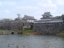
The Book of Song records that King Bu, thought to be the Emperor Yūryaku, sent a letter in 478 seeking the Chinese emperor's approval for the establishment of three ministries for administration of the kingdom similar to those in use in China; the remains of a ward office and temple in Ooho (大保), 15 km (9 mi) south from Dazaifu, may be one of these ministries. In addition, remains of the Kōrokan (鴻臚館, Government Guest House) were found in Fukuoka underneath a part of the ruins of Fukuoka Castle.
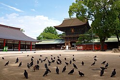
In 923, the Hakozaki Shrine in Fukuoka was established when the god Hachiman was transferred from the Daibu shrine in Honami.[7]
-
-

-
 Korokan


There are several historically important Buddhist temples in Fukuoka. Monks would sail back to Japan from China upon completing their studies and establish temples in the heart of the port city of Hakata (now Fukuoka): Monk Eisai founded Shōfuku-ji which is known today as the oldest zen temple in Japan. Eisai is also known for establishing a new sect of Zen Buddhism (Rinzai) and for bringing tea and tea culture to Japan. Monk Kukai established Tocho-ji, and Joten-ji was built by Enni who is also known for bringing Udon noodles first from China to Japan.

Hakata Jion Yamagata is the most famous festival in Fukuoka and the origin of it is believed to date back to 1241, when Enni, the founder of Jotenji temple had people carry him around the town on a platform while praying against the plague and eventually getting successfully rid of it. [8]
Mongol invasions (1274–1281)
Kublai Khan of the Mongol Empire turned his attention towards Japan starting in 1268, exerting a new external pressure on Japan with which it had no experience. Kublai Khan first sent an envoy to Japan to make the Shogunate acknowledge Khan's suzerainty.[9] The Kamakura shogunate refused. Mongolia repeatedly sent envoys thereafter, each time urging the Shogunate to accept their proposal, but to no avail.
In 1274, Kublai Khan mounted an invasion of the northern part of Kyushu with a fleet of 900 ships and 33,000 troops, including troops from Goryeo on the Korean Peninsula.[10] This initial invasion was compromised by a combination of incompetence and severe storms. After the invasion attempt of 1274, Japanese samurai built a stone barrier 20 km (12 mi) in length bordering the coast of Hakata Bay in what is now the city of Fukuoka. The wall, 2–3 metres in height and having a base width of 3 meters, was constructed between 1276 and 1277, and was excavated in the 1930s.
Kublai sent another envoy to Japan in 1279. At that time, Hōjō Tokimune of the Hōjō clan (1251–1284) was the Eighth Regent. Not only did he decline the offer, but he beheaded the five Mongolian emissaries after summoning them to Kamakura. Infuriated, Kublai organized another attack on Fukuoka Prefecture in 1281, mobilizing 140,000 soldiers and 4,000 ships. The Japanese defenders, numbering around 40,000, were no match for the Mongols and the invasion force made it as far as Dazaifu, 15 km (9 mi) south of the city of Fukuoka. However, the Japanese were again aided by severe weather, this time by a typhoon that struck a crushing blow to the Mongolian troops, thwarting the invasion.[11]
It was this typhoon that came to be called the Kamikaze (Divine Wind), and was the origin of the term Kamikaze used to indicate suicide attacks by military aviators of the Empire of Japan against Allied naval vessels during World War II.[12]

_-_panoramio.jpg)
Formation of the modern city (1889)
Fukuoka was formerly the residence of the powerful daimyō of Chikuzen Province, and played an important part in the medieval history of Japan. The renowned temple of Tokugawa Ieyasu in the district was destroyed by fire during the Boshin War of 1868.
The modern city was formed on April 1, 1889, with the merger of the former cities of Hakata and Fukuoka. Historically, Hakata was the port and merchant district, and was more associated with the area's culture and remains the main commercial area today. On the other hand, the Fukuoka area was home to many samurai, and its name has been used since Kuroda Nagamasa, the first daimyō of Chikuzen Province, named it after his birthplace in Okayama Prefecture[13] and the "old Fukuoka" is the main shopping district, now called Tenjin.[14]
When Hakata and Fukuoka decided to merge, a meeting was held to decide the name for the new city, and after multiple ties, Fukuoka ultimately was chosen.[15][16] However, Hakata is still used to refer to the Hakata area of the city and, most famously, to refer to the city's train station, Hakata Station, and dialect, Hakata-ben.
-
-
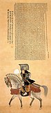
 Fukuoka and Hakata, c. 1640
 -
-


20th century
- 1903: Fukuoka Medical College, a campus associated with Kyoto Imperial University, is founded. In 1911, the college is renamed Kyushu Imperial University and established as a separate entity.
- 1910: Fukuoka streetcar service begins. (The service ran until 1979.)
- 1929: Flights commence along the Fukuoka-Osaka-Tokyo route.
- 1945: Fukuoka was firebombed on June 19, with the attack destroying 21.5 percent of the city's urban area.[13]
- 1947: First Fukuoka Marathon.
- 1951: Fukuoka airport opens.[17]
- 1953: Fukuoka Zoo opens.
- 1975: The city absorbed the town of Sawara.
- 1975: Sanyō Shinkansen high-speed railway reaches Hakata station.
- 1981: Subway commences service.
- 1988: Osaka's pro baseball team, the Nankai Hawks, was moved to Fukuoka and renamed the Fukuoka Daiei Hawks (renamed the Fukuoka SoftBank Hawks in 2004).
- 1989: Asian-Pacific Exposition is held.[18]
- 1997: The 30th annual meeting of the Asian Development Bank was held in Fukuoka.
-
-
 Fukuoka war damage monument


21st century
- 2005: Fukuoka subway Nanakuma Line started operations.
- 2014: Selected as the National Strategic Zone for "global startups & job creation" by Japanese government.[19]
Geography

Fukuoka is bordered on three sides by mountains, surrounds Hakata Bay and opens on the north to the Genkai Sea. It is located 1,100 km (684 mi) from Tokyo.
The nearest overseas region is Busan Metropolitan City in Gyeongsang-do, South Korea, and the distance from Busan is about 180 km (112 miles). Fukuoka and Busan are sister cities.
Climate
Fukuoka has a humid subtropical climate (Köppen: Cfa), hot and humid summers, and relatively mild winters.[20] The city also sees on average about 1,600 mm (63 in) of precipitation per year, with a stretch of more intense precipitation between the months of June and September.
Along with much of the prefecture, Fukuoka City has a moderate climate with an annual average temperature of 16.3 °C (61 °F), average humidity of 70% and 1,811 annual sunshine hours. Roughly 40% of the year is cloudy.
Winter temperatures rarely drop below 0 °C (32 °F) and snow cover is rarely seen, though very light snow does fall on many days if not as consistently as on the Sea of Japan side of Honshu.[21] Spring is warm and sunnier, with cherry blossoms appearing in late March or early April. The rainy season (tsuyu) lasts for approximately six weeks through June and July, during which time the humidity is very high and temperatures hover between 25 °C (77 °F) and 30 °C (86 °F). Summers are humid and hot, with temperatures peaking around 37 °C (99 °F). Autumn, often considered to be Fukuoka's best season, is mild and dry, though the typhoon season runs between August and September.
| Climate data for Fukuoka (1991−2020 normals, extremes 1890−present) | |||||||||||||
|---|---|---|---|---|---|---|---|---|---|---|---|---|---|
| Month | Jan | Feb | Mar | Apr | May | Jun | Jul | Aug | Sep | Oct | Nov | Dec | Year |
| Record high °C (°F) | 21.5 (70.7) |
24.3 (75.7) |
26.3 (79.3) |
30.1 (86.2) |
32.3 (90.1) |
37.3 (99.1) |
38.3 (100.9) |
38.1 (100.6) |
37.1 (98.8) |
33.3 (91.9) |
28.2 (82.8) |
26.0 (78.8) |
38.3 (100.9) |
| Mean daily maximum °C (°F) | 10.2 (50.4) |
11.6 (52.9) |
15.0 (59.0) |
19.9 (67.8) |
24.4 (75.9) |
27.2 (81.0) |
31.2 (88.2) |
32.5 (90.5) |
28.6 (83.5) |
23.7 (74.7) |
18.2 (64.8) |
12.6 (54.7) |
21.3 (70.3) |
| Daily mean °C (°F) | 6.9 (44.4) |
7.8 (46.0) |
10.8 (51.4) |
15.4 (59.7) |
19.9 (67.8) |
23.3 (73.9) |
27.4 (81.3) |
28.4 (83.1) |
24.7 (76.5) |
19.6 (67.3) |
14.2 (57.6) |
9.1 (48.4) |
17.3 (63.1) |
| Mean daily minimum °C (°F) | 3.9 (39.0) |
4.4 (39.9) |
7.2 (45.0) |
11.5 (52.7) |
16.1 (61.0) |
20.3 (68.5) |
24.6 (76.3) |
25.4 (77.7) |
21.6 (70.9) |
16.0 (60.8) |
10.6 (51.1) |
5.8 (42.4) |
14.0 (57.2) |
| Record low °C (°F) | −6.0 (21.2) |
−8.2 (17.2) |
−4.7 (23.5) |
−1.4 (29.5) |
1.4 (34.5) |
4.3 (39.7) |
13.8 (56.8) |
15.4 (59.7) |
7.9 (46.2) |
0.4 (32.7) |
−2.1 (28.2) |
−5.4 (22.3) |
−8.2 (17.2) |
| Average precipitation mm (inches) | 74.4 (2.93) |
69.8 (2.75) |
103.7 (4.08) |
118.2 (4.65) |
133.7 (5.26) |
249.6 (9.83) |
299.1 (11.78) |
210.0 (8.27) |
175.1 (6.89) |
94.5 (3.72) |
91.4 (3.60) |
67.5 (2.66) |
1,686.9 (66.41) |
| Average snowfall cm (inches) | 1 (0.4) |
1 (0.4) |
0 (0) |
0 (0) |
0 (0) |
0 (0) |
0 (0) |
0 (0) |
0 (0) |
0 (0) |
0 (0) |
0 (0) |
2 (0.8) |
| Average precipitation days (≥ 0.5 mm) | 11.0 | 10.7 | 11.4 | 10.8 | 9.8 | 12.7 | 12.4 | 11.2 | 11.0 | 7.9 | 9.9 | 10.2 | 128.9 |
| Average relative humidity (%) | 63 | 62 | 63 | 64 | 67 | 75 | 75 | 72 | 73 | 68 | 66 | 63 | 68 |
| Mean monthly sunshine hours | 104.1 | 123.5 | 161.2 | 188.1 | 204.1 | 145.2 | 172.2 | 200.9 | 164.7 | 175.9 | 137.3 | 112.2 | 1,889.4 |
| Average ultraviolet index | 3 | 4 | 6 | 8 | 9 | 10 | 11 | 10 | 8 | 6 | 4 | 3 | 7 |
| Source: Japan Meteorological Agency[22] and Weather Atlas[23] | |||||||||||||
Disaster
Earthquakes
Fukuoka is not as seismically active as many other parts of Japan, but does experience occasional earthquakes. The most powerful recent earthquake registered a lower 6 of maximum 7 of the Japanese intensity scale and hit at 10:53 am local time on March 20, 2005, killing one person and injuring more than 400.[24] The epicentre of the earthquake was in the Genkai Sea along a yet-undiscovered extension of the Kego fault that runs through the centre of Fukuoka. Genkai island, a part of Nishi-ku, was the most severely damaged by the earthquake and almost all island residents were forced to evacuate. Aftershocks continued intermittently throughout the following weeks as construction crews worked to rebuild damaged buildings throughout the city. Traditional Japanese houses, particularly in the areas of Daimyo and Imaizumi, were the most heavily damaged and many were marked for demolition, along with several apartment buildings. Insurance payments for damages were estimated at 15.8 billion yen.[25]
A similar quake, with an intensity of 5+, also occurred one month later on April 20, 2005.
Fukuoka's major Kego fault runs northwest to southeast, roughly parallel to Nishitetsu's Ōmuta train line, and was previously thought to be 22 km (14 mi) long. It is estimated to produce earthquakes as strong as magnitude 7 at the focus approximately once every 15,000 years. If the focus were located at a depth of 10 km (6 mi), this would translate to an earthquake of a lower-6 magnitude (similar to the March 20, 2005 earthquake) in downtown Fukuoka if it were the epicenter. The probability of an earthquake along the known length of the Kego fault occurring within 30 years was estimated at 0.4% prior to the March 20, 2005 earthquake, but this probability has been revised upwards since. Including the new extension out into the Genkai Sea, the Kego fault is now thought to be 40 km (25 mi) long.
Following reports that the city has only prepared for earthquakes up to a magnitude of 6.5, several strong aftershocks renewed fears regarding the portion of the Kego fault that lies under the city, and the potential for an earthquake as big as, or bigger than, the March 20 quake.[26]
Wards
Fukuoka has 7 wards (ku).