

A | B | C | D | E | F | G | H | CH | I | J | K | L | M | N | O | P | Q | R | S | T | U | V | W | X | Y | Z | 0 | 1 | 2 | 3 | 4 | 5 | 6 | 7 | 8 | 9
Native name: Κρήτη | |
|---|---|
 NASA photograph of Crete | |
 | |
| Geography | |
| Location | Eastern Mediterranean |
| Coordinates | 35°12.6′N 24°54.6′E / 35.2100°N 24.9100°E |
| Area | 8,450 km2 (3,260 sq mi) |
| Area rank | 88 |
| Highest elevation | 2,456 m (8058 ft) |
| Highest point | Mount Ida (Psiloritis) |
| Administration | |
| Region | Crete |
| Capital city | Heraklion |
| Largest settlement | Heraklion (pop. 144,442[1]) |
| Demographics | |
| Demonym | Cretan, archaic Cretian |
| Population | 624,408 (2021)[2] |
| Population rank | 73 |
| Pop. density | 74.9/km2 (194/sq mi) |
| Ethnic groups | Greeks; historically, Minoans, Eteocretans, Cydonians and Pelasgians |
| Additional information | |
| Time zone |
|
| ISO code | GR-M |
| HDI (2019) 0.879[3] very high · 3rd of 13 | |
Crete (/kriːt/ KREET; Greek: Κρήτη, Modern: Kríti [ˈkriti], Ancient: Krḗtē [krɛ̌ːtεː]) is the largest and most populous of the Greek islands, the 88th largest island in the world and the fifth largest island in the Mediterranean Sea, after Sicily, Sardinia, Cyprus, and Corsica. Crete rests about 160 km (99 mi) south of the Greek mainland, and about 100 km (62 mi) southwest of Anatolia. Crete has an area of 8,450 km2 (3,260 sq mi) and a coastline of 1,046 km (650 mi). It bounds the southern border of the Aegean Sea, with the Sea of Crete (or North Cretan Sea) to the north and the Libyan Sea (or South Cretan Sea) to the south. Crete covers 260 km from west to east but is narrow from north to south, spanning three longitudes but only half a latitude.
Crete and a number of islands and islets that surround it constitute the Region of Crete (Greek: Περιφέρεια Κρήτης), which is the southernmost of the 13 top-level administrative units of Greece, and the fifth most populous of Greece's regions. Its capital and largest city is Heraklion, on the north shore of the island. As of 2020[update], the region had a population of 636,504.[4] The Dodecanese are located to the northeast of Crete, while the Cyclades are situated to the north, separated by the Sea of Crete. The Peloponnese is to the region's northwest.
Crete was the centre of Europe's first advanced civilization, the Minoans, from 2700 to 1420 BC. The Minoan civilization was overrun by the Mycenaean civilization from mainland Greece. Crete was later ruled by Rome, then successively by the Byzantine Empire, Andalusian Arabs, the Venetian Republic, and the Ottoman Empire. In 1898 Crete, whose people had for some time wanted to join the Greek state, achieved independence from the Ottomans, formally becoming the Cretan State. Crete became part of Greece in December 1913.
The island is mostly mountainous, and its character is defined by a high mountain range crossing from west to east. It includes Crete's highest point, Mount Ida, and the range of the White Mountains (Lefka Ori) with 30 summits above 2,000 metres (6,600 ft) in altitude and the Samaria Gorge, a World Biosphere Reserve. Crete forms a significant part of the economy and cultural heritage of Greece, while retaining its own local cultural traits (such as its own poetry and music). The Nikos Kazantzakis airport at Heraklion and the Daskalogiannis airport at Chania serve international travelers. The Minoan palace at Knossos is also located in Heraklion.[5]
Name
| ||||||
| Keftiu in hieroglyphs | ||||||
|---|---|---|---|---|---|---|
The earliest references to the island of Crete come from texts from the Syrian city of Mari dating from the 18th century BC, where the island is referred to as Kaptara.[6] This is repeated later in Neo-Assyrian records and the Bible (Caphtor). It was known in ancient Egyptian as Keftiu or kftı͗w, strongly suggesting a similar Minoan name for the island.[7]
The current name Crete is first attested in the 15th century BC in Mycenaean Greek texts, written in Linear B, through the words ke-re-te (𐀐𐀩𐀳, *Krētes; later Greek: Κρῆτες [krɛː.tes], plural of Κρής [krɛːs])[8] and ke-re-si-jo (𐀐𐀩𐀯𐀍, *Krēsijos; later Greek: Κρήσιος [krέːsios],[9] 'Cretan').[10][11] In Ancient Greek, the name Crete (Κρήτη) first appears in Homer's Odyssey.[12] Its etymology is unknown. One proposal derives it from a hypothetical Luwian word *kursatta (compare kursawar 'island', kursattar 'cutting, sliver').[13] Another proposal suggests that it derives from the ancient Greek word "κραταιή" (krataie̅), meaning strong or powerful, the reasoning being that Crete was the strongest thalassocracy during ancient times.[14][15]
In Latin, the name of the island became Creta. The original Arabic name of Crete was Iqrīṭiš (Arabic: اقريطش < (τῆς) Κρήτης), but after the Emirate of Crete's establishment of its new capital at ربض الخندق Rabḍ al-Ḫandaq (modern Heraklion; Greek: Ηράκλειο, Irákleio), both the city and the island became known as Χάνδαξ (Chandax) or Χάνδακας (Chandakas), which gave Latin, Italian, and Venetian Candia, from which were derived French Candie and English Candy or Candia. Under Ottoman rule, in Ottoman Turkish, Crete was called Girit (كريد). In the Hebrew Bible, Crete is referred to as (כְּרֵתִים) "kretim".
Physical geography and climate


.jpg)
Crete is the largest island in Greece and the fifth largest island in the Mediterranean Sea. It is located in the southern part of the Aegean Sea separating the Aegean from the Libyan Sea.
Island morphology
The island has an elongated shape: it spans 260 km (160 mi) from east to west, is 60 km (37 mi) at its widest point, and narrows to as little as 12 km (7.5 mi) (close to Ierapetra). Crete covers an area of 8,336 km2 (3,219 sq mi), with a coastline of 1,046 km (650 mi); to the north, it broaches the Sea of Crete (Greek: Κρητικό Πέλαγος); to the south, the Libyan Sea (Greek: Λιβυκό Πέλαγος); in the west, the Myrtoan Sea, and toward the east the Carpathian Sea. It lies approximately 160 km (99 mi) south of the Greek mainland.
There are a number of peninsulas and gulfs on the north side of Crete, from west to east these include: Gramvousa peninsula, gulf of Kissamos, Rodopos peninsula, gulf of Chania, Akrotiri peninsula, Souda Bay, Apokoronas cape, gulf of Almiros, gulf of Heraklion, Aforesmenos cape, gulf of Mirabello, gulf of Sitia and the Sideros peninsula. On the south side of Crete is the gulf of Messaras and Cape Lithinon.
Mountains and valleys
Crete is mountainous, and its character is defined by a high mountain range crossing from west to east, formed by six different groups of mountains:
- The White Mountains or Lefka Ori 2,453 m (8,048 ft)
- The Idi Range (Psiloritis) 2,456 m (8,058 ft)
- Asterousia Mountains 1,231 m (4,039 ft)
- Kedros 1,777 m (5,830 ft)
- The Dikti Mountains 2,148 m (7,047 ft)
- Thrypti 1,489 m (4,885 ft)
These mountains lavish Crete with valleys, such as Amari valley, fertile plateaus, such as Lasithi plateau, Omalos and Nidha; caves, such as Gourgouthakas, Diktaion, and Idaion (the birthplace of the ancient Greek god Zeus); and a number of gorges.
The mountains have been seen as a key feature of the island's distinctiveness, especially since the time of Romantic travellers' writing. Contemporary Cretans distinguish between highlanders and lowlanders; the former often claim to reside in places affording a higher/better climatic and moral environment. In keeping with the legacy of Romantic authors, the mountains are seen as having determined their residents' 'resistance' to past invaders which relates to the oft-encountered idea that highlanders are 'purer' in terms of less intermarriages with occupiers. For residents of mountainous areas, such as Sfakia in western Crete, the aridness and rockiness of the mountains is emphasised as an element of pride and is often compared to the alleged soft-soiled mountains of others parts of Greece or the world.[16]
Gorges, rivers and lakes
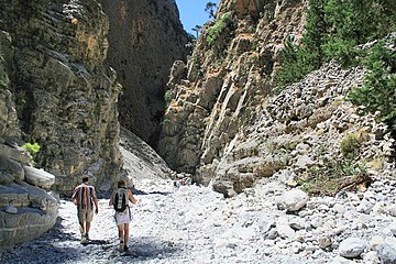
The island has a number of gorges, such as the Samariá Gorge, Imbros Gorge, Kourtaliotiko Gorge, Ha Gorge, Platania Gorge, the Gorge of the Dead (at Kato Zakros, Sitia) and Richtis Gorge and (Richtis) waterfall at Exo Mouliana in Sitia.[17][18][19][20]
The rivers of Crete include the Geropotamos River, the Koiliaris, the Anapodiaris, the Almiros, the Giofyros, the Keritis, and Megas Potamos. There are only two freshwater lakes in Crete: Lake Kournas and Lake Agia, which are both in Chania regional unit.[21] Lake Voulismeni at the coast, at Aghios Nikolaos, was formerly a freshwater lake but is now connected to the sea, in Lasithi.[22] Three artificial lakes created by dams also exist in Crete: the lake of Aposelemis Dam, the lake of Potamos Dam, and the lake of Mpramiana Dam.
-

-
-
 Aradaina Gorge
 -
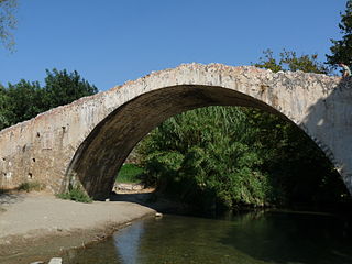 Venetian Bridge over Megalopotamos River


Surrounding islands

A large number of islands, islets, and rocks hug the coast of Crete. Many are visited by tourists, some are only visited by archaeologists and biologists. Some are environmentally protected. A small sample of the islands includes:
- Gramvousa (Kissamos, Chania) the pirate island opposite the Balo lagoon
- Elafonisi (Chania), which commemorates a shipwreck and an Ottoman massacre
- Chrysi island (Ierapetra, Lasithi), which hosts the largest natural Juniperus macrocarpa forest in Europe
- Paximadia island (Agia Galini, Rethymno) where the god Apollo and the goddess Artemis were born
- The Venetian fort and leper colony at Spinalonga opposite the beach and shallow waters of Elounda (Agios Nikolaos, Lasithi)
- Dionysades islands which are in an environmentally protected region together with the Palm Beach Forest of Vai in the municipality of Sitia, Lasithi
Off the south coast, the island of Gavdos is located 26 nautical miles (48 km) south of Hora Sfakion and is the southernmost point of Europe.
Climate
Crete straddles two climatic zones, the Mediterranean and the semi-arid climate, mainly falling within the former. As such, the climate in Crete is primarily a hot-summer Mediterranean (Csa) climate while some areas in the south and east have a hot semi-arid climate (Köppen climate classification: BSh). The higher elevations fall into the warm-summer Mediterranean climate category (Csb)[23] while the mountain peaks (>2,000 meters) might feature a cold-summer Mediterranean climate (Csc) or a continental climate (Dfb or Dfc). The atmosphere can be quite humid, depending on the proximity to the sea, while winter is fairly mild. Snowfall is common on the mountains between November and May, but rare in the low-lying areas.

The south coast, including the Mesara Plain and Asterousia Mountains, falls in the North African climatic zone, enjoying significantly more sunny days and high temperatures throughout the year. There, date palms bear fruit, and swallows remain year-round rather than migrate to Africa. The fertile region around Ierapetra, on the southeastern corner of the island, has year-round agricultural production, with summer vegetables and fruit produced in greenhouses throughout the winter.[24] Western Crete (Chania province) receives more rain and the soils there suffer more erosion compared to the Eastern part of Crete.[25]
Average annual temperatures reach up to 21.0°C in South Crete. Crete holds the record for the highest temperatures ever recorded in Europe during October, November, January and February from World Meteorological Organization stations.[26] [27] [28] [29] [30] According to the Hellenic National Meteorological Service, South Crete receives the most sunshine in Greece with more than 3,257 hours of sunshine per year.[31]
| Climate data for Heraklion 1955-2010 (HNMS) | |||||||||||||
|---|---|---|---|---|---|---|---|---|---|---|---|---|---|
| Month | Jan | Feb | Mar | Apr | May | Jun | Jul | Aug | Sep | Oct | Nov | Dec | Year |
| Record high °C (°F) | 29.9 (85.8) |
28.8 (83.8) |
34.0 (93.2) |
37.5 (99.5) |
38.0 (100.4) |
41.3 (106.3) |
43.6 (110.5) |
44.5 (112.1) |
39.5 (103.1) |
37.0 (98.6) |
32.8 (91.0) |
28.5 (83.3) |
44.5 (112.1) |
| Mean daily maximum °C (°F) | 15.3 (59.5) |
15.5 (59.9) |
17.0 (62.6) |
20.1 (68.2) |
23.6 (74.5) |
27.3 (81.1) |
28.9 (84.0) |
28.8 (83.8) |
26.6 (79.9) |
23.6 (74.5) |
20.2 (68.4) |
17.1 (62.8) |
22.0 (71.6) |
| Daily mean °C (°F) | 12.1 (53.8) |
12.2 (54.0) |
13.6 (56.5) |
16.6 (61.9) |
20.4 (68.7) |
24.5 (76.1) |
26.4 (79.5) |
26.3 (79.3) |
23.7 (74.7) |
20.3 (68.5) |
16.8 (62.2) |
13.8 (56.8) |
18.9 (66.0) |
| Mean daily minimum °C (°F) | 9.1 (48.4) |
8.9 (48.0) |
9.8 (49.6) |
12.0 (53.6) |
15.1 (59.2) |
19.2 (66.6) |
21.9 (71.4) |
22.0 (71.6) |
19.5 (67.1) |
16.7 (62.1) |
13.5 (56.3) |
10.9 (51.6) |
14.9 (58.8) |
| Record low °C (°F) | 0.0 (32.0) |
−0.8 (30.6) |
0.3 (32.5) |
4.2 (39.6) |
Zdroj:https://en.wikipedia.org?pojem=Crete|||||||||