

A | B | C | D | E | F | G | H | CH | I | J | K | L | M | N | O | P | Q | R | S | T | U | V | W | X | Y | Z | 0 | 1 | 2 | 3 | 4 | 5 | 6 | 7 | 8 | 9
| Adelaide South Australia | |||||||||
|---|---|---|---|---|---|---|---|---|---|
 Map of Adelaide, Australia, printable and editable | |||||||||
 Adelaide | |||||||||
| Coordinates | 34°55′39″S 138°36′00″E / 34.92750°S 138.60000°E | ||||||||
| Population | 1,418,455 (2022)[1] (5th) | ||||||||
| • Density | 426/km2 (1,100/sq mi) | ||||||||
| Established | 28 December 1836 | ||||||||
| Area | 3,259.8 km2 (1,258.6 sq mi)[2] | ||||||||
| Time zone | ACST (UTC+9:30) | ||||||||
| • Summer (DST) | ACDT (UTC+10:30) | ||||||||
| Location | |||||||||
| LGA(s) | 19 municipalities across Metropolitan Adelaide | ||||||||
| State electorate(s) | Various (34) | ||||||||
| Federal division(s) | Spence, Makin, Hindmarsh, Adelaide, Sturt, Boothby, Kingston | ||||||||
| |||||||||

_(33505366456)_(cropped).jpg)

.jpg)

.jpg)
.jpg)

Adelaide (/ˈædɪleɪd/ AD-il-ayd,[8][9] locally [ˈædɜlæɪ̯d]; Kaurna: Tarntanya, pronounced [ˈd̪̥aɳɖaɲa]) is the capital and largest city of South Australia,[10] and the fifth-most populous city in Australia. "Adelaide" may refer to either Greater Adelaide (including the Adelaide Hills) or the Adelaide city centre. The demonym Adelaidean is used to denote the city and the residents of Adelaide. The traditional owners of the Adelaide region are the Kaurna.[11][12][13] The area of the city centre and surrounding Park Lands is called Tarndanya in the Kaurna language.[14]
Adelaide is situated on the Adelaide Plains north of the Fleurieu Peninsula, between the Gulf St Vincent in the west and the Mount Lofty Ranges in the east. Its metropolitan area extends 20 km (12 mi) from the coast to the foothills of the Mount Lofty Ranges, and stretches 96 km (60 mi) from Gawler in the north to Sellicks Beach in the south.
Named in honour of Queen Adelaide of Saxe-Meiningen, wife of King William IV, the city was founded in 1836 as the planned capital for the only freely-settled British province in Australia.[15] Colonel William Light, one of Adelaide's founding fathers, designed the city centre and chose its location close to the River Torrens. Light's design, now listed as national heritage, set out the city centre in a grid layout known as "Light's Vision", interspaced by wide boulevards and large public squares, and entirely surrounded by park lands.
Early colonial Adelaide was shaped by the diversity and wealth of its free settlers, in contrast to the convict history of other Australian cities. It was Australia's third most populated city until the post-war era. It has been noted for its leading examples of religious freedom and progressive political reforms, and became known as the "City of Churches" due to its diversity of faiths. The city has also been reputed for its automotive scene, having been home to vehicle operations of Holden, Chrysler Australia, and Mitsubishi Motors Australia. Furthermore, the city was also the host of the first series of the Australian Grand Prix in the FIA Formula One World Championship from 1982 to 1995. Today, Adelaide is known by its many festivals and sporting events, its food and wine, its coastline and hills, its large defence and manufacturing sectors and its emerging space sector, including the Australian Space Agency being headquartered here. Adelaide's quality of life has ranked consistently highly in various measures through the 21st century, at one stage being named Australia's most liveable city.[16]
As South Australia's government and commercial centre, Adelaide is the site of many governmental and financial institutions. Most of these are concentrated in the city centre along the cultural boulevards of North Terrace and King William Street.
History
Before European settlement

The area around modern-day Adelaide was originally inhabited by the Indigenous Kaurna people, one of many Aboriginal nations in South Australia. The city and parklands area was known as Tarntanya,[17] Tandanya, now the short name of Tandanya National Aboriginal Cultural Institute, Tarndanya,[18] or Tarndanyangga, now the dual name for Victoria Square, in the Kaurna language.[19] The name means 'male red kangaroo rock', referring to a rock formation on the site that has now been destroyed.[20]
The surrounding area was an open grassy plain with patches of trees and shrubs which had been managed by hundreds of generations. Kaurna country encompassed the plains which stretched north and south of Tarntanya as well as the wooded foothills of the Mt Lofty Ranges. The River Torrens was known as the Karrawirra Pari (Red Gum forest river). About 300 Kaurna populated the Adelaide area, and were referred to by the settlers as the Cowandilla.[21]
There were more than 20 local clans across the plain who lived semi-nomadic lives, with extensive mound settlements where huts were built repeatedly over centuries and a complex social structure including a class of sorcerers separated from regular society.[22]
Within a few decades of European settlement of South Australia, Kaurna culture was almost completely destroyed. The last speaker of Kaurna language died in 1929.[23] Extensive documentation by early missionaries and other researchers has enabled a modern revival of both,[24] which has included a commitment by local and state governments to rename or include Kaurna names for many local places.[25][26]
19th century


Based on the ideas of Edward Gibbon Wakefield about colonial reform, Robert Gouger petitioned the British government to create a new colony in Australia, resulting in the passage of the South Australia Act 1834. Physical establishment of the colony began with the arrival of the first British colonisers in February 1836. The first governor proclaimed the commencement of colonial government in South Australia on 28 December 1836, near The Old Gum Tree in what is now the suburb of Glenelg North. The event is commemorated in South Australia as Proclamation Day.[27] The site of the colony's capital was surveyed and laid out by Colonel William Light, the first surveyor-general of South Australia, with his own original, unique, topographically sensitive design. The city was named after Queen Adelaide.[28]
Adelaide was established as a planned colony of free immigrants, promising civil liberties and freedom from religious persecution, based upon the ideas of Edward Gibbon Wakefield. Wakefield had read accounts of Australian settlement while in prison in London for attempting to abduct an heiress,[29] and realised that the eastern colonies suffered from a lack of available labour, due to the practice of giving land grants to all arrivals.[30] Wakefield's idea was for the Government to survey and sell the land at a rate that would maintain land values high enough to be unaffordable for labourers and journeymen.[31] Funds raised from the sale of land were to be used to bring out working-class emigrants, who would have to work hard for the monied settlers to ever afford their own land.[32] As a result of this policy, Adelaide does not share the convict settlement history of other Australian cities like Sydney, Brisbane and Hobart.

As it was believed that in a colony of free settlers there would be little crime, no provision was made for a gaol in Colonel Light's 1837 plan. But by mid-1837 the South Australian Register was warning of escaped convicts from New South Wales and tenders for a temporary gaol were sought. Following a burglary, a murder, and two attempted murders in Adelaide during March 1838, Governor Hindmarsh created the South Australian Police Force (now the South Australia Police) in April 1838 under 21-year-old Henry Inman.[33] The first sheriff, Samuel Smart, was wounded during a robbery, and on 2 May 1838 one of the offenders, Michael Magee, became the first person to be hanged in South Australia.[34] William Baker Ashton was appointed governor of the temporary gaol in 1839, and in 1840 George Strickland Kingston was commissioned to design Adelaide's new gaol.[35] Construction of Adelaide Gaol commenced in 1841.[36]
Adelaide's early history was marked by economic uncertainty and questionable leadership.[dubious ] The first governor of South Australia, John Hindmarsh, clashed frequently with others, in particular the Resident Commissioner, James Hurtle Fisher. The rural area surrounding Adelaide was surveyed by Light in preparation to sell a total of over 405 km2 (156 sq mi) of land. Adelaide's early economy started to get on its feet in 1838 with the arrival of livestock from Victoria, New South Wales and Tasmania. Wool production provided an early basis for the South Australian economy. By 1860, wheat farms had been established from Encounter Bay in the south to Clare in the north.

George Gawler took over from Hindmarsh in late 1838 and, despite being under orders from the Select Committee on South Australia in Britain not to undertake any public works, promptly oversaw construction of a governor's house, the Adelaide Gaol, police barracks, a hospital, a customs house and a wharf at Port Adelaide. Gawler was recalled and replaced by George Edward Grey in 1841. Grey slashed public expenditure against heavy opposition, although its impact was negligible at this point: silver was discovered in Glen Osmond that year, agriculture was well underway, and other mines sprung up all over the state, aiding Adelaide's commercial development. The city exported meat, wool, wine, fruit and wheat by the time Grey left in 1845, contrasting with a low point in 1842 when one-third of Adelaide houses were abandoned.
Trade links with the rest of the Australian states were established after the Murray River was successfully navigated in 1853 by Francis Cadell, an Adelaide resident. South Australia became a self-governing colony in 1856 with the ratification of a new constitution by the British parliament. Secret ballots were introduced, and a bicameral parliament was elected on 9 March 1857, by which time 109,917 people lived in the province.[37]
In 1860, the Thorndon Park reservoir was opened, providing an alternative water source to the now turbid River Torrens. Gas street lighting was implemented in 1867, the University of Adelaide was founded in 1874, the South Australian Art Gallery opened in 1881 and the Happy Valley Reservoir opened in 1896. In the 1890s Australia was affected by a severe economic depression, ending a hectic era of land booms and tumultuous expansionism. Financial institutions in Melbourne and banks in Sydney closed. The national fertility rate fell and immigration was reduced to a trickle.[38]
The value of South Australia's exports nearly halved. Drought and poor harvests from 1884 compounded the problems, with some families leaving for Western Australia.[38] Adelaide was not as badly hit as the larger gold-rush cities of Sydney and Melbourne, and silver and lead discoveries at Broken Hill provided some relief. Only one year of deficit was recorded, but the price paid was retrenchments and lean public spending. Wine and copper were the only industries not to suffer a downturn.[39]
20th century

.jpg)
Adelaide was Australia's third largest city for most of the 20th century.[40][41][42] Electric street lighting was introduced in 1900 and electric trams were transporting passengers in 1909. 28,000 men were sent to fight in World War I. Historian F. W. Crowley examined the reports of visitors in the early 20th century, noting that "many visitors to Adelaide admired the foresighted planning of its founders", as well as pondering the riches of the young city.[43]
Adelaide enjoyed a postwar boom, entering a time of relative prosperity. Its population grew, and it became the third most populous metropolitan area in the country, after Sydney and Melbourne. Its prosperity was short-lived, with the return of droughts and the Great Depression of the 1930s. It later returned to fortune under strong government leadership. Secondary industries helped reduce the state's dependence on primary industries. World War II brought industrial stimulus and diversification to Adelaide under the Playford Government, which advocated Adelaide as a safe place for manufacturing due to its less vulnerable location.[44] Shipbuilding was expanded at the nearby port of Whyalla.
The South Australian Government in this period built on former wartime manufacturing industries but neglected cultural facilities which meant South Australia's economy lagged behind.[40] International manufacturers like Holden and Chrysler[45] made use of these factories around the Adelaide area in suburbs like Elizabeth, completing its transformation from an agricultural service centre to a 20th-century motor city. The Mannum–Adelaide pipeline brought River Murray water to Adelaide in 1955 and an airport opened at West Beach in 1955. Flinders University and the Flinders Medical Centre were established in the 1960s at Bedford Park, south of the city. Today, Flinders Medical Centre is one of the largest teaching hospitals in South Australia. In the post-war years around the early 1960s, Adelaide was surpassed by Brisbane as Australia's third largest city.[40]
The Dunstan Governments of the 1970s saw something of an Adelaide 'cultural revival',[46] establishing a wide array of social reforms. The city became noted for its progressivism as South Australia became the first Australian state or territory to decriminalise homosexuality between consenting adults in 1975.[47] Adelaide became a centre for the arts, building upon the biennial "Adelaide Festival of Arts" that commenced in 1960. The State Bank collapsed in 1991 during an economic recession. The effects lasted until 2004, when Standard & Poor's reinstated South Australia's AAA credit rating.[48] Adelaide's tallest building, completed in 2020, is called the Adelaidean and is located at 11 Frome Street.[49]
21st century

In the early years of the 21st century, a significant increase in the state government's spending on Adelaide's infrastructure occurred. The Rann government invested A$535 million in a major upgrade of the Adelaide Oval to enable Australian Football League to be played in the city centre[50] and more than A$2 billion to build a new Royal Adelaide Hospital on land adjacent to the Adelaide Railway Station.[51] The Glenelg tramline was extended through the city to Hindmarsh[52] down to East Terrace[53] and the suburban railway line extended south to Seaford.[54]
Following a period of stagnation in the 1990s and 2000s, Adelaide began several major developments and redevelopments. The Adelaide Convention Centre was redeveloped and expanded at a cost of A$350 million beginning in 2012.[55] Three historic buildings were adapted for modern use: the Torrens Building in Victoria Square as the Adelaide campus for Carnegie Mellon University, University College London, and Torrens University;[56] the Stock Exchange building as the Science Exchange of the Royal Institution Australia; and the Glenside Psychiatric Hospital as the Adelaide Studios of the SA Film Corporation. The government invested more than A$2 billion to build a desalination plant, powered by renewable energy, as an 'insurance policy' against droughts affecting Adelaide's water supply.[57] The Adelaide Festival, Fringe, and Womadelaide became annual events.[58]

Geography
Adelaide is north of the Fleurieu Peninsula, on the Adelaide Plains between the Gulf St Vincent and the low-lying Mount Lofty Ranges. The city stretches 20 km (12 mi) from the coast to the foothills, and 90 km (56 mi) from Gawler at its northern extent to Sellicks Beach in the south. According to the Regional Development Australia, an Australian government planning initiative, the "Adelaide Metropolitan Region" has a total land area of 870 km2 (340 sq mi), while a more expansive definition by the Australian Bureau of Statistics defines a "Greater Adelaide" statistical area totalling 3,259.8 km2 (1,258.6 sq mi).[2] The city sits at an average elevation of 50 metres (160 ft) above sea level. Mount Lofty, east of the Adelaide metropolitan region in the Adelaide Hills at an elevation of 727 metres (2,385 ft), is the tallest point of the city and in the state south of Burra. The city borders the Temperate Grassland of South Australia in the east, an endangered vegetation community.[59]

Much of Adelaide was bushland before British settlement, with some variation – sandhills, swamps and marshlands were prevalent around the coast. The loss of the sandhills to urban development had a particularly destructive effect on the coastline due to erosion.[60] Where practical, the government has implemented programs to rebuild and vegetate sandhills at several of Adelaide's beachside suburbs. Tennyson Dunes is the largest contiguous, tertiary dune system contained entirely within Metropolitan Adelaide, providing refuge for a variety of remnant species formerly found along the entire coastline.[61] Much of the original vegetation has been cleared with what is left to be found in reserves such as the Cleland National Park and Belair National Park. A number of creeks and rivers flow through the Adelaide region. The largest are the Torrens and Onkaparinga catchments. Adelaide relies on its many reservoirs for water supply with the Happy Valley Reservoir supplying around 40% and the much larger Mount Bold Reservoir 10% of Adelaide's domestic requirements respectively.
Geology
Adelaide and its surrounding area is one of the most seismically active regions in Australia. On 1 March 1954 at 3:40 am Adelaide experienced its largest recorded earthquake to date, with the epicentre 12 km from the city centre at Darlington, and a reported magnitude of 5.6.[62][63] There have been smaller earthquakes in 2010,[64] 2011,[65] 2014,[66] 2017,[67] 2018[68] and 2022.[69]
The uplands of the Adelaide Hills, part of the southern Mount Lofty Ranges to the east of Adelaide, are defined on their western side by a number of arcuate faults (the Para, Eden, Clarendon and Willunga Faults), and consist of rocks such as siltstone, dolomite and quartzite, dating from the Neoproterozoic to the middle Cambrian, laid down in the Adelaide Rift Complex, the oldest part of the Adelaide Superbasin.[70]
Most of the Adelaide metropolitan area lies in the downthrown St Vincent Basin and its embayments, including the Adelaide Plains Sub-basin, and the Golden Grove, Noarlunga and Willunga Embayments. These basins contain deposits of Tertiary marine and non-marine sands and limestones, which form important aquifers.[71] These deposits are overlain by Quaternary alluvial fans and piedmont slope deposits, derived from erosion of the uplands, consisting of sands, clays and gravels,[72] interfingering to the west with transgressive Pleistocene to Holocene marine sands and coastal sediments of the shoreline of Gulf St Vincent.[73]
Urban layout
Adelaide is a planned city, designed by the first Surveyor-General of South Australia, Colonel William Light. His plan, sometimes referred to as "Light's Vision" (also the name of a statue of him on Montefiore Hill), arranged Adelaide in a grid, with five squares in the Adelaide city centre and a ring of parks, known as the Adelaide Parklands, surrounding it. Light's selection of the location for the city was initially unpopular with the early settlers, as well as South Australia's first governor, John Hindmarsh, due to its distance from the harbour at Port Adelaide, and the lack of fresh water there.[74]

Light successfully persisted with his choice of location against this initial opposition. Recent evidence suggests that Light worked closely with George Kingston as well as a team of men to set out Adelaide, using various templates for city plans going back to Ancient Greece, including Italian Renaissance designs and the similar layouts of the American cities Philadelphia and Savannah–which, like Adelaide, follow the same layout of a central city square, four complementing city squares surrounding it and a parklands area that surrounds the city centre.[75]

The benefits of Light's design are numerous: Adelaide has had wide multi-lane roads from its beginning, an easily navigable cardinal direction grid layout and an expansive green ring around the city centre. There are two sets of ring roads in Adelaide that have resulted from the original design. The inner ring route (A21) borders the parklands, and the outer route (A3/A13/A16/A17) completely bypasses the inner city via (in clockwise order) Grand Junction Road, Hampstead Road, Ascot Avenue, Portrush Road, Cross Road and South Road.[76]
Suburban expansion has to some extent outgrown Light's original plan. Numerous former outlying villages and "country towns", as well as the satellite city of Elizabeth, have been enveloped by its suburban sprawl. Expanding developments in the Adelaide Hills region led to the construction of the South Eastern Freeway to cope with growth, which has subsequently led to new developments and further improvements to that transport corridor. Similarly, the booming development in Adelaide's South led to the construction of the Southern Expressway.
New roads are not the only transport infrastructure developed to cope with the urban growth. The O-Bahn Busway is an example of a unique solution to Tea Tree Gully's transport woes in the 1980s.[77] The development of the nearby suburb of Golden Grove in the late 1980s is an example of well-thought-out urban planning.
In the 1960s, a Metropolitan Adelaide Transport Study Plan was proposed to cater for the future growth of the city. The plan involved the construction of freeways, expressways and the upgrade of certain aspects of the public transport system. The then premier Steele Hall approved many parts of the plan and the government went as far as purchasing land for the project. The later Labor government elected under Don Dunstan shelved the plan, but allowed the purchased land to remain vacant, should the future need for freeways arise. In 1980, the Liberal party won government and premier David Tonkin committed his government to selling off the land acquired for the MATS plan, ensuring that even when needs changed, the construction of most MATS-proposed freeways would be impractical. Some parts of this land have been used for transport, (e.g. the O-Bahn Busway and Southern Expressway), while most has been progressively subdivided for residential use.
In 2008, the SA Government announced plans for a network of transport-oriented developments across the Adelaide metropolitan area and purchased a 10 hectare industrial site at Bowden for $52.5 million as the first of these developments.[78][79]
Housing

Historically, Adelaide's suburban residential areas have been characterised by single-storey detached houses built on 1,000-square-metre (1⁄4-acre) blocks. A relative lack of suitable, locally-available timber for construction purposes led to the early development of a brick-making industry, as well as the use of stone, for houses and other buildings. By 1891, 68% of houses were built of stone, 15% of timber, and 10% of brick, with brick also being widely used in stone houses for quoins, door and window surrounds, and chimneys and fireplaces.[80]
There is a wide variety in the styles of these houses. Until the 1960s, most of the more substantial houses were built of red brick, though many front walls were of ornamental stone. Then cream bricks became fashionable, and in the 1970s, deep red and brown bricks became popular.[citation needed] Until the 1970s, roofs tended to be clad with (painted) corrugated iron or cement or clay tiles, usually red "terracotta". Since then, Colorbond corrugated steel has dominated. Most roofs are pitched. Flat roofs are not common.[81]
Up to the 1970s, most houses were of "double brick" construction on concrete footings, with timber floors laid on joists supported by "dwarf walls". Later houses have mainly been of "brick veneer" construction – structural timber or, more recently, lightweight steel frame on a concrete slab foundation, lined with Gyprock, and with an outer skin of brickwork,[81] to cope with Adelaide's reactive soils, particularly Keswick Clay, black earth and some red-brown earth soils.[82] The use of precast concrete panels for floor and wall construction has also increased.[81] In addition to this, a significant factor in Adelaide's suburban history is the role of the South Australian Housing Trust.[why?]
-

-
 Two-storey house in North Adelaide. Much of Adelaide's early housing was built with bluestone.
 -
 Heritage-listed bluestone 19th-century house in the city centre
 -
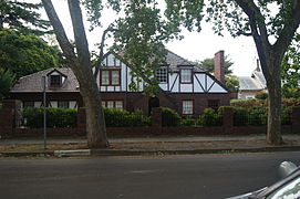 Tudor Revival house in Unley Park
 -
 House in Lockleys with two distinguishing features that characterise Adelaide houses: a brush fence and red brick veneer.
.jpg)
.jpg)

.jpg)

Climate

Adelaide has a hot-summer Mediterranean climate (Csa) under the Köppen climate classification.[83] The city has hot, dry summers and cool winters with moderate rainfall. Most precipitation falls in the winter months, leading to the suggestion that the climate be classified as a "cold monsoon".[84] Rainfall is unreliable, light and infrequent throughout summer, although heavy falls can occur. The winter has fairly reliable rainfall with June being the wettest month of the year, averaging around 80 mm. Frosts are occasional, with the most notable occurrences in 1908 and 1982. Hail is common in winter.
Adelaide is a windy city with significant wind chill in winter, which makes the temperature seem colder than it actually is. Snowfall in the metropolitan area is extremely rare, although light and sporadic falls in the nearby hills and at Mount Lofty occur during winter. Dewpoints in the summer typically range from 8 to 10 °C (46 to 50 °F). There are usually several days in summer where the temperature reaches 40.0 °C (104.0 °F) or above; the frequency of these temperatures has been increasing in recent years.[85] Temperature extremes range from -0.4 °C (31.4 °F), 8 June 1982 to 47.7 °C (117.9 °F), 24 January 2019. The city features 90.6 clear days annually.
The average sea temperature ranges from 13.7 °C (56.7 °F) in August to 21.2 °C (70.2 °F) in February.[86]
| Climate data for Adelaide (Kent Town) 1991–2020 averages, 1977–2020 extremes | |||||||||||||
|---|---|---|---|---|---|---|---|---|---|---|---|---|---|
| Month | Jan | Feb | Mar | Apr | May | Jun | Jul | Aug | Sep | Oct | Nov | Dec | Year |
| Record high °C (°F) | 47.7 (117.9) |
44.7 (112.5) |
42.2 (108.0) |
36.9 (98.4) |
31.1 (88.0) |
25.4 (77.7) |
23.1 (73.6) |
30.4 (86.7) |
34.3 (93.7) |
39.0 (102.2) |
43.0 (109.4) |
45.2 (113.4) |
47.7 (117.9) |
| Mean daily maximum °C (°F) | 30.0 (86.0) |
29.7 (85.5) |
26.6 (79.9) |
23.0 (73.4) |
19.0 (66.2) |
16.2 (61.2) |
15.6 (60.1) |
16.7 (62.1) |
19.3 (66.7) |
22.5 (72.5) |
25.4 (77.7) |
27.6 (81.7) |
22.6 (72.7) |
| Daily mean °C (°F) | 23.8 (74.8) |
23.6 (74.5) |
21.0 (69.8) |
17.9 (64.2) |
14.6 (58.3) |
12.3 (54.1) |
11.7 (53.1) |
12.4 (54.3) |
14.6 (58.3) |
17.1 (62.8) |
19.8 (67.6) |
21.7 (71.1) |
17.5 (63.5) |
| Mean daily minimum °C (°F) | 17.6 (63.7) |
17.5 (63.5) |
15.3 (59.5) |
12.7 (54.9) |
10.2 (50.4) |
8.3 (46.9) |
7.7 (45.9) |
8.1 (46.6) |
9.9 (49.8) |
11.7 (53.1) |
14.1 (57.4) |
15.8 (60.4) |
12.4 (54.3) |
| Record low °C (°F) | 9.2 (48.6) |
9.5 (49.1) |
7.2 (45.0) |
4.3 (39.7) |
1.5 (34.7) |
−0.4 (31.3) |
0.4 (32.7) |
0.9 (33.6) |
2.6 (36.7) |
4.7 (40.5) |
5.3 (41.5) |
7.9 (46.2) |
−0.4 (31.3) |
| Average rainfall mm (inches) | 21.2 (0.83) |
20.0 (0.79) |
24.9 (0.98) |
37.6 (1.48) |
59.3 (2.33) |
77.7 (3.06) |
71.1 (2.80) |
66.9 (2.63) |
59.6 (2.35) |
40.0 (1.57) |
31.0 (1.22) |
28.3 (1.11) |
536.5 (21.12) |
| Average rainy days (≥ 0.2 mm) | 4.7 | 3.7 | 5.9 | 8.2 | 12.7 | 14.6 | 16.3 | 16.2 | 13.5 | 9.9 | 8.3 | 7.2 | 121.2 |
| Average afternoon relative humidity (%) | 36 | 36 | 40 | 45 | 55 | 61 | 59 | 54 | 50 | 44 | 40 | 38 | 47 |
| Mean monthly sunshine hours | 325.5 | 285.3 | 266.6 | 219.0
Zdroj:https://en.wikipedia.org?pojem=Adelaide,_South_Australia Text je dostupný za podmienok Creative Commons Attribution/Share-Alike License 3.0 Unported; prípadne za ďalších podmienok. Podrobnejšie informácie nájdete na stránke Podmienky použitia.
Analytika
Antropológia Aplikované vedy Bibliometria Dejiny vedy Encyklopédie Filozofia vedy Forenzné vedy Humanitné vedy Knižničná veda Kryogenika Kryptológia Kulturológia Literárna veda Medzidisciplinárne oblasti Metódy kvantitatívnej analýzy Metavedy Metodika Text je dostupný za podmienok Creative
Commons Attribution/Share-Alike License 3.0 Unported; prípadne za ďalších
podmienok. www.astronomia.sk | www.biologia.sk | www.botanika.sk | www.dejiny.sk | www.economy.sk | www.elektrotechnika.sk | www.estetika.sk | www.farmakologia.sk | www.filozofia.sk | Fyzika | www.futurologia.sk | www.genetika.sk | www.chemia.sk | www.lingvistika.sk | www.politologia.sk | www.psychologia.sk | www.sexuologia.sk | www.sociologia.sk | www.veda.sk I www.zoologia.sk | |||||||||