A | B | C | D | E | F | G | H | CH | I | J | K | L | M | N | O | P | Q | R | S | T | U | V | W | X | Y | Z | 0 | 1 | 2 | 3 | 4 | 5 | 6 | 7 | 8 | 9
| Zugspitze | |
|---|---|
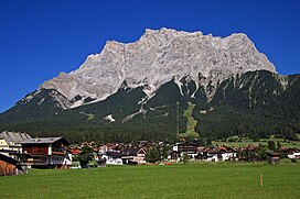
 Zugspitze from Ehrwald, Tyrol, Austria | |
| Highest point | |
| Elevation | 2,962 m (9,718 ft)[1] |
| Prominence | 1,746 m (5,728 ft)[2] ↓ Fern Pass → Parseierspitze |
| Parent peak | Finsteraarhorna / Mont Blancb |
| Isolation | 25.8 km → Zwölferkogel[Note 1] |
| Listing | Country high point (Germany) Ultra |
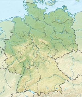
| Coordinates | 47°25′16″N 10°59′07″E / 47.42111°N 10.98528°E[2] |
| Geography | |
| Location | Tyrol, Austria Bavaria, Germany |
| Parent range | Wettersteingebirge, Eastern Alps |
| Geology | |
| Age of rock | Triassic |
| Mountain type | Wetterstein limestone[3] |
| Climbing | |
| First ascent | 27 August 1820 by Josef Naus, Johann Georg Tauschl and survey assistant, Maier |
| Easiest route | Reintal Route |
The Zugspitze (/ˈzʊɡʃpɪtsə/ ZUUG-shpit-sə,[4] German: [ˈtsuːkˌʃpɪtsə] ; lit. ' path peak'), at 2,962 m (9,718 ft) above sea level, is the highest peak of the Wetterstein Mountains and the highest mountain in Germany. It lies south of the town of Garmisch-Partenkirchen in Bavaria, and the Austria–Germany border is on its western summit. South of the mountain is the Zugspitzplatt, a high karst plateau with numerous caves. On the flanks of the Zugspitze are two glaciers, the largest in Germany: the Northern Schneeferner with an area of 30.7 hectares and Höllentalferner with an area of 24.7 hectares. Shrinking of the Southern Schneeferner led to the loss of glacier status in 2022.[5]
The Zugspitze was first climbed on 27 August 1820 by Josef Naus; his survey assistant, Maier, and mountain guide, Johann Georg Tauschl. Today there are three normal routes to the summit: one from the Höllental valley to the northeast; another out of the Reintal valley to the southeast; and the third from the west over the Austrian Cirque (Österreichische Schneekar). One of the best known ridge routes in the Eastern Alps runs along the knife-edged Jubilee Ridge (Jubiläumsgrat) to the summit, linking the Zugspitze, the Hochblassen and the Alpspitze. For mountaineers there is plenty of nearby accommodation. On the western summit of the Zugspitze itself is the Münchner Haus and on the western slopes is the Wiener-Neustädter Hut.
Three cable cars run to the top of the Zugspitze. The first, the Tyrolean Zugspitze Cable Car, was built in 1926 by the German company Adolf Bleichert & Co[6] and terminated on an arête below the summit at 2,805 m.a.s.l, the so-called Kammstation, before the terminus was moved to the actual summit at 2,951 m.a.s.l. in 1991. A rack railway, the Bavarian Zugspitze Railway, runs inside the northern flank of the mountain and ends on the Zugspitzplatt, from where a second cable car runs a short way down to the Schneefernerhaus, formerly a hotel, but since 1999 an environmental research station; a weather station opened there in 1900. The rack railway and the Eibsee Cable Car, the third cableway, transport an average of 500,000 people to the summit each year. In winter, nine ski lifts cover the ski area on the Zugspitzplatt.
Geography
The Zugspitze belongs to the Wetterstein range of the Northern Limestone Alps. The Austria–Germany border goes right over the mountain. There used to be a border checkpoint at the summit but, since Germany and Austria are now both part of the Schengen zone, the border crossing is no longer staffed.
The exact height of the Zugspitze was a matter of debate for quite a while. Given figures ranged from 2,690–2,970 metres (8,830–9,740 ft), but it is now generally accepted that the peak is 2,962 m (9,718 ft) above sea level as a result of a survey carried out by the Bavarian State Survey Office. The lounge at the new café is named "2962" for this reason.
Location

At 2,962 metres (9,718 ft) (eastern peak) the Zugspitze is the highest mountain of the Zugspitze massif. This height is referenced to the Amsterdam Gauge and is given by the Bavarian State Office for Survey and Geoinformation.[7] The same height is recorded against the Trieste Gauge used in Austria, which is 27 cm lower. Originally the Zugspitze had three peaks: the east, middle and west summits (Ost-, Mittel- and Westgipfel). The only one that has remained in its original form is the east summit, which is also the only one that lies entirely on German territory. The middle summit fell victim to one of the cable car summit stations in 1930. In 1938 the west summit was blown up to create a building site for a planned flight control room for the Wehrmacht. This was never built however. Originally the height of the west summit was given as 2,964 m (9,724 ft).[8]
The mountain rises eleven kilometres southwest of Garmisch-Partenkirchen and just under six kilometres east of Ehrwald. The border between Germany and Austria runs over the west summit; thus the Zugspitze massif belongs to the German state of Bavaria and the Austrian state of Tyrol. The municipalities responsible for it are Grainau and Ehrwald. To the west the Zugspitze massif drops into the valley of the River Loisach, which flows around the massif towards the northeast in a curve whilst, in the east, the streams of Hammersbach and Partnach have their source. To the south the Gaistal valley and its river, the Leutascher Ache, separate the Wetterstein Mountains from the Mieming Chain. To the north at the foot of the Zugspitze is the lake of Eibsee. The next highest mountain in the area is the Acherkogel (3,008 m or 9,869 ft) in the Stubai Alps, which gives the Zugspitze a topographic isolation value of 24.6 kilometres. The reference point for the prominence is the Parseierspitze (3,036 m or 9,961 ft). In order to climb it from the Zugspitze, a descent to the Fern Pass (1,216 m or 3,990 ft) is required, so that the prominence is 1,746 m (5,728 ft).[9]
Zugspitze Massif

The massif of the Zugspitze has several other peaks. To the south the Zugspitzplatt is surrounded in an arc by the Zugspitzeck (2,820 m or 9,250 ft) and Schneefernerkopf (2,874 m or 9,429 ft), the Wetterspitzen (2,747 m or 9,012 ft), the Wetterwandeck (2,698 m or 8,852 ft), the Plattspitzen (2,679 m or 8,789 ft) and the Gatterlköpfen (2,490 m or 8,170 ft). The massif ends in the Gatterl (2,024 m or 6,640 ft), a wind gap between it and the Hochwanner. Running eastwards away from the Zugspitze is the famous Jubilee Ridge or Jubiläumsgrat over the Höllentalspitzen towards the Alpspitze and Hochblassen. The short crest of the Riffelwandkamm runs northeast over the summits of the Riffelwandspitzen (2,626 m or 8,615 ft) and the Riffelköpfe (2,459 m or 8,068 ft), to the Riffel wind gap (Riffelscharte, 2,161 m or 7,090 ft). From here the ridge of the Waxensteinkamm stretches away over the Riffelspitzen to the Waxenstein.[10]
Zugspitzplatt

The Platt or Zugspitzplatt is a plateau below the summit of the Zugspitze to the south and southeast which lies at a height of between 2,000 and 2,650 m (6,560 and 8,690 ft). It forms the head of the Reintal valley and has been shaped by a combination of weathering, karstification and glaciation. The area contains roches moutonnées, dolines and limestone pavements as a consequence of the ice ages. In addition moraines have been left behind by various glacial periods. The Platt was completely covered by a glacier for the last time at the beginning of the 19th century. Today 52 percent of it consists of scree, 32 percent of bedrock and 16 percent of vegetation-covered soils, especially in the middle and lower areas.[11]
Climate
The climate is tundra (Köppen: ET),[12] maintaining the only glacier present in Germany, which has observed its reduction over the years.[13] From a climatic perspective the Zugspitze lies in the temperate zone and its prevailing winds are Westerlies. As the first high orographic obstacle to these Westerlies in the Alps, the Zugspitze is particularly exposed to the weather. It is effectively the north barrier of the Alps (Nordstau der Alpen), against which moist air masses pile up and release heavy precipitation. At the same time the Zugspitze acts as a protective barrier for the Alpine ranges to the south. By contrast, Föhn weather conditions push in the other direction against the massif, affecting the region for about 60 days per year. These warm, dry air masses stream from south to north and can result in unusually high temperatures in winter. Nevertheless, frost dominates the picture on the Zugspitze with an average of 310 days per year.

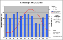
For the decades from 1961 to 1990 – designated by the World Meteorological Organization as the "normal period" – the average annual precipitation on the Zugspitze was 2,003.1 mm; the wettest month being April with 199 mm, and the driest, October with 108.8 mm.[14] By comparison the values for 2009 were 2,070.8 mm, the wettest month being March with 326.2 mm and the driest, January, with 56.4 mm.[15] The average temperature in the normal period was −4.8 Celsius, with July and August being the warmest at 2.2 °C and February, the coldest, with −11.4 °C.[14] By comparison the average temperature in 2009 was −4.2 °C, the warmest month was August at 5.3 °C and the coldest was February at −13.5 °C.[15] The average sunshine during the normal period was 1,846.3 hours per year, the sunniest month being October with 188.8 hours and the darkest being December with 116.1 hours.[14] In 2009 there were 1,836.3 hours of sunshine, the least occurring in February with just 95.4 hours and the most in April with 219 hours.[15] In 2009, according to the weather survey by the German Met Office, the Zugspitze was the coldest place in Germany with a mean annual temperature of −4.2 °C.[16]
The lowest measured temperature on the Zugspitze was −35.6 °C on 14 February 1940. The highest temperature occurred on 5 July 1957 when the thermometer reached 17.9 °C. A squall on 12 June 1985 registered 335 km/h, the highest measured wind speed on the Zugspitze. In April 1944 meteorologists recorded a snow depth of 8.3 metres.[17][18] Nowadays, snow completely melts during summer, but in the past snow might resist the summer months, the last case when the snow failed to melt during the whole summer season was in 2000.
| Climate data for Zugspitze, (elevation 2,965 m (9,728 ft), 1991−2020 normals, extremes 1900–present) | |||||||||||||
|---|---|---|---|---|---|---|---|---|---|---|---|---|---|
| Month | Jan | Feb | Mar | Apr | May | Jun | Jul | Aug | Sep | Oct | Nov | Dec | Year |
| Record high °C (°F) | 6.1 (43.0) |
5.8 (42.4) |
5.3 (41.5) |
9.3 (48.7) |
14.8 (58.6) |
16.8 (62.2) |
17.9 (64.2) |
16.7 (62.1) |
17.2 (63.0) |
12.7 (54.9) |
7.4 (45.3) |
5.2 (41.4) |
17.9 (64.2) |
| Mean daily maximum °C (°F) | −7.3 (18.9) |
−8.0 (17.6) |
−6.3 (20.7) |
−3.2 (26.2) |
0.9 (33.6) |
4.5 (40.1) |
6.5 (43.7) |
6.9 (44.4) |
3.3 (37.9) |
0.6 (33.1) |
−3.6 (25.5) |
−6.4 (20.5) |
−1.0 (30.2) |
| Daily mean °C (°F) | −10.1 (13.8) |
−10.9 (12.4) |
−9.0 (15.8) |
−6.2 (20.8) |
−2.0 (28.4) |
1.5 (34.7) |
3.4 (38.1) |
3.8 (38.8) |
0.5 (32.9) |
−2.0 (28.4) |
−6.3 (20.7) |
−9.2 (15.4) |
−3.9 (25.0) |
| Mean daily minimum °C (°F) | −12.7 (9.1) |
−13.5 (7.7) |
−11.6 (11.1) |
−8.7 (16.3) |
−4.4 (24.1) |
−0.9 (30.4) |
0.9 (33.6) |
1.4 (34.5) |
−1.9 (28.6) |
−4.5 (23.9) |
−8.8 (16.2) |
−11.8 (10.8) |
−6.4 (20.5) |
| Record low °C (°F) | −34.6 (−30.3) |
−35.6 (−32.1) |
−31.0 (−23.8) |
−24.2 (−11.6) |
−19.8 (−3.6) |
−12.5 (9.5) |
−8.7 (16.3) |
−9.9 (14.2) |
−14.7 (5.5) |
−18.3 (−0.9) |
−25.9 (−14.6) |
−31.1 (−24.0) |
−35.6 (−32.1) |
| Average precipitation mm (inches) | 176.5 (6.95) |
157.4 (6.20) |
208.1 (8.19) |
171.7 (6.76) |
192.7 (7.59) |
181.4 (7.14) |
184.5 (7.26) |
184.6 (7.27) |
150.2 (5.91) |
127.6 (5.02) |
157.4 (6.20) |
183.3 (7.22) |
2,075.5 (81.71) |
| Average precipitation days (≥ 0.1 mm) | 17.4 | 16.9 | 19.6 | 18.4 | 20.8 | 21.0 | 20.3 | 19.2 | 16.6 | 14.9 | 16.0 | 18.2 | 219.3 |
| Average snowy days (≥ 1.0 cm) | 31.0 | 28.3 | 31.0 | 30.0 | 31.0 | 30.0 | 27.6 | 15.2 | 19.4 | 27.8 | 29.8 | 31.0 | 333.0 |
| Average relative humidity (%) | 68.7 | 71.8 | 76.3 | 81.1 | 85.8 | 87.0 | 86.8 | 84.8 | 81.7 | 73.5 | 73.8 | 71.8 | 78.6 |
| Mean monthly sunshine hours | 138.3 | 140.0 | 168.0 | 177.3 | 172.8 | 162.3 | 171.4 | 177.0 | 167.6 | 175.4 | 131.8 | 120.5 | 1,902.6 |
| Source 1: NOAA[19] | |||||||||||||
| Source 2: DWD (extremes)[20] | |||||||||||||
| Climate data for Zugspitze, elevation: 2,965 m (9,728 ft), 1981-2010 normals | |||||||||||||
|---|---|---|---|---|---|---|---|---|---|---|---|---|---|
| Month | Jan | Feb | Mar | Apr | May | Jun | Jul | Aug | Sep | Oct | Nov | Dec | Year |
| Mean daily maximum °C (°F) | −7.5 (18.5) |
−8.2 (17.2) |
−6.9 (19.6) |
−3.8 (25.2) |
0.9 (33.6) |
3.7 (38.7) |
6.3 (43.3) |
6.3 (43.3) |
3.1 (37.6) |
0.7 (33.3) |
−4.4 (24.1) |
−6.7 (19.9) |
−1.3 (29.7) |
| Daily mean °C (°F) | −10.3 (13.5) |
−11.1 (12.0) |
−9.7 (14.5) |
−6.9 (19.6) |
−2.1 (28.2) |
0.7 (33.3) |
3.1 (37.6) |
3.2 (37.8) |
0.4 (32.7) |
−2.0 (28.4) |
−7.1 (19.2) |
−9.6 (14.7) |
−4.3 (24.3) |
| Mean daily minimum °C (°F) | −13.0 (8.6) |
−13.8 (7.2) |
−12.3 (9.9) |
−9.4 (15.1) |
−4.6 (23.7) |
−1.8 (28.8) |
0.6 (33.1) |
0.8 (33.4) |
−2.0 (28.4) |
−4.5 (23.9) |
−9.6 (14.7) |
−12.2 (10.0) |
−6.8 (19.8) |
| Average precipitation mm (inches) | 172.4 (6.79) |
159.8 (6.29) Zdroj:https://en.wikipedia.org?pojem=Zugspitzplatt Text je dostupný za podmienok Creative Commons Attribution/Share-Alike License 3.0 Unported; prípadne za ďalších podmienok. Podrobnejšie informácie nájdete na stránke Podmienky použitia.
Analytika
Antropológia Aplikované vedy Bibliometria Dejiny vedy Encyklopédie Filozofia vedy Forenzné vedy Humanitné vedy Knižničná veda Kryogenika Kryptológia Kulturológia Literárna veda Medzidisciplinárne oblasti Metódy kvantitatívnej analýzy Metavedy Metodika Text je dostupný za podmienok Creative
Commons Attribution/Share-Alike License 3.0 Unported; prípadne za ďalších
podmienok. www.astronomia.sk | www.biologia.sk | www.botanika.sk | www.dejiny.sk | www.economy.sk | www.elektrotechnika.sk | www.estetika.sk | www.farmakologia.sk | www.filozofia.sk | Fyzika | www.futurologia.sk | www.genetika.sk | www.chemia.sk | www.lingvistika.sk | www.politologia.sk | www.psychologia.sk | www.sexuologia.sk | www.sociologia.sk | www.veda.sk I www.zoologia.sk | |||||||||||


