

A | B | C | D | E | F | G | H | CH | I | J | K | L | M | N | O | P | Q | R | S | T | U | V | W | X | Y | Z | 0 | 1 | 2 | 3 | 4 | 5 | 6 | 7 | 8 | 9
Wiesbaden | |
|---|---|
 Flag  Coat of arms | |
Location of Wiesbaden within Hessen  | |
 Wiesbaden  Wiesbaden | |
| Coordinates: 50°04′57″N 08°14′24″E / 50.08250°N 8.24000°E | |
| Country | Germany |
| State | Hesse |
| Admin. region | Darmstadt |
| District | Urban district |
| Founded | 121 |
| Subdivisions | 26 boroughs |
| Government | |
| • Lord mayor (2019–25) | Gert-Uwe Mende[1] (SPD) |
| • Governing parties | CDU / SPD |
| Area | |
| • Total | 203.9 km2 (78.7 sq mi) |
| Elevation | 115 m (377 ft) |
| Population (2022-12-31)[2] | |
| • Total | 283,083 |
| • Density | 1,400/km2 (3,600/sq mi) |
| Time zone | UTC+01:00 (CET) |
| • Summer (DST) | UTC+02:00 (CEST) |
| Postal codes | 65183–65207 55246 (Mainz-Kostheim) 55252 (Mainz-Kastel) |
| Dialling codes | 0611, 06122, 06127, 06134 |
| Vehicle registration | WI |
| Website | wiesbaden.de |


.jpg)


Wiesbaden (German pronunciation: [ˈviːsˌbaːdn̩] ⓘ; lit. 'meadow baths') is the capital of the German state of Hesse, and the second-largest Hessian city after Frankfurt am Main. With around 283,000 inhabitants, it is Germany's 24th-largest city. Wiesbaden forms a conurbation with a population of around 500,000 with the neighbouring city of Mainz. This conurbation is in turn embedded in the Rhine-Main Metropolitan Region—Germany's second-largest metropolitan region after Rhine-Ruhr—which also includes the nearby cities of Frankfurt am Main, Darmstadt, Offenbach am Main, and Hanau, and has a combined population exceeding 5.8 million.
The city is located on the Rhine, at the foothills of the Taunus, opposite the Rhineland-Palatine capital of Mainz, and the city centre is located in the wide valley of the small Salzbach stream. Wiesbaden lies in the Rheingau wine-growing region, one of Germany's 13 wine regions. Three of Wiesbaden's boroughs were part of the city of Mainz until 1945, and still bear the designation "Mainz" in their names—the so-called AKK-boroughs of Mainz-Amöneburg, Mainz-Kastel, and Mainz-Kostheim. This so-called AKK-Konflikt (de:AKK-Konflikt) is the main cause for the rivalry between Mainz and Wiesbaden. Wiesbaden Main Station is connected to Frankfurt am Main by the Rhine-Main S-Bahn rapid transit system.
Historically, Wiesbaden was a Nassauian city. From 1170 to 1629, it lay in the County of Nassau, and from 1629 to 1721, it was in the county and later principality of Nassau-Idstein, all of which were territories within the Holy Roman Empire ruled by branches of the House of Nassau. In 1728, the city found itself in the principality of Nassau-Usingen, and in 1744, Biebrich Palace became the main residence of the House of Nassau-Usingen. In 1806, the city became the capital of the Duchy of Nassau. Since 1841, the newly built Wiesbaden City Palace was the principal Nassauian residence. From 1868 to 1944, the city lay in the Prussian Province of Hesse-Nassau, and from 1944 to 1945, it was the capital of the Province of Nassau. In 1945, it became the capital of Greater Hesse and subsequently, in 1946, of Hesse.
Wiesbaden is one of the oldest spa towns in Europe. Its name translates to "meadow baths", and there are 15 mineral springs—14 of which are hot springs—in the city centre.[3] With a yield of around 2 million liters daily, Wiesbaden is the second-most productive German spa after Aachen. Its location in a mountain basin at the southern foot of the Taunus, protected by the mountains in the north and west, gives Wiesbaden a mild climate. It has been called the "Nice of the North" because of its climate and architecture.[4] The city of Wiesbaden is one of the wealthiest cities in Germany and one of those with above-average purchasing power.[5] The United States Army Europe and Africa headquarters are located in Wiesbaden-Erbenheim.
Geographical setting
Wiesbaden is situated on the right (northern) bank of the Rhine, above the confluence of the Main, where the Rhine's main direction changes from north to west. The city is across the Rhine from Mainz, the capital of the state of Rhineland-Palatinate. Frankfurt am Main is located about 38 kilometres (23.6 mi) east. To the north of the city are the Taunus Mountains, which trend in a northeasterly direction.
The city center, the Stadtmitte, is located in the north-easternmost part of the Upper Rhine Valley at the spurs of the Taunus mountains, about 5 kilometres (3.1 mi) from the Rhine. The landscape is formed by a wide lowland between the Taunus heights in the north, the Bierstadter Höhe and the Hainerberg in the east, the Mosbacher Mountain in the south, and the Schiersteiner Mountain in the west, an offshoot of the Taunus range.
The downtown is drained only by the narrow valley of the Salzbach, a tributary of the Rhine, on the eastern flanks of the Mosbacher Mountain. The city's main railway line and the Mainz road (Mainzer Straße) follow this valley. Several other streams drain into the Salzbach within the city center: the Wellritzbach, the Kesselbach, the Schwarzbach, the Dambach, and the Tennelbach, as well as the outflow of many thermal and mineral springs in the Kurhaus (spa) district. Above the city center, the Salzbach is better known as the Rambach.
The highest point of the Wiesbaden municipality is located northwest of the city center near the summit of the Hohe Wurzel, with an elevation of 608 metres (1,995 ft) above sea level. The lowest point is the harbour entrance of Schierstein at 83 metres (272 ft) above sea level. The central square (the Schlossplatz, or palace square) is at an elevation of 115 metres (377 ft).
Wiesbaden covers an area of 204 km2 (79 sq mi). It is 17.6 kilometres (10.9 mi) from north to south and 19.7 kilometres (12.2 mi) from west to east. In the north are vast forest areas, which cover 27.4% of the urban area. In the west and east are vineyards and agricultural land, which cover 31.1% of the area. Of the municipality's 79 kilometres (49.1 mi)-long border, the Rhine makes up 10.3 kilometres (6.4 mi).
Climate
Wiesbaden has a temperate-oceanic climate (Köppen: Cfb) with relatively cold winters and warm summers. Its average annual temperature is 9.8 °C (49.6 °F), with monthly mean temperatures ranging from 1.0 °C (33.8 °F) in January to 18.6 °C (65.5 °F) in July.
| Climate data for Wiesbaden | |||||||||||||
|---|---|---|---|---|---|---|---|---|---|---|---|---|---|
| Month | Jan | Feb | Mar | Apr | May | Jun | Jul | Aug | Sep | Oct | Nov | Dec | Year |
| Mean daily maximum °C (°F) | 4 (39) |
6 (43) |
11 (52) |
15 (59) |
20 (68) |
23 (73) |
25 (77) |
25 (77) |
20 (68) |
14 (57) |
8 (46) |
5 (41) |
14.7 (58.5) |
| Daily mean °C (°F) | 1.0 (33.8) |
2.2 (36.0) |
5.5 (41.9) |
9.4 (48.9) |
13.8 (56.8) |
17.0 (62.6) |
18.6 (65.5) |
18.0 (64.4) |
14.6 (58.3) |
10.0 (50.0) |
4.9 (40.8) |
2.1 (35.8) |
9.8 (49.6) |
| Mean daily minimum °C (°F) | −1 (30) |
−1 (30) |
2 (36) |
5 (41) |
9 (48) |
12 (54) |
14 (57) |
14 (57) |
11 (52) |
7 (45) |
3 (37) |
1 (34) |
6.3 (43.3) |
| Average precipitation mm (inches) | 48 (1.9) |
41 (1.6) |
46 (1.8) |
41 (1.6) |
55 (2.2) |
68 (2.7) |
66 (2.6) |
63 (2.5) |
49 (1.9) |
49 (1.9) |
57 (2.2) |
55 (2.2) |
638 (25.1) |
| Average precipitation days (≥ 1 mm) | 10 | 8 | 8 | 9 | 10 | 10 | 10 | 10 | 8 | 8 | 10 | 10 | 111 |
| Source: Sonnenlaender.de[6] | |||||||||||||
History

Classical antiquity
While evidence of settlement at present-day Wiesbaden dates back to the Neolithic era, historical records document continuous occupancy after the erection of a Roman fort in 6 AD which housed an auxiliary cavalry unit. The thermal springs of Wiesbaden are first mentioned in Pliny the Elder's Naturalis Historia. They were famous for their recreation pools for Roman army horses and possibly as the source of a mineral used for red hair dye (which was very fashionable around the turn of BC/AD among women in Rome).[8]
The Roman settlement is first mentioned using the name Aquae Mattiacorum (Latin for "Waters of the Mattiaci") in 121. The Mattiaci were a Germanic tribe, possibly a branch of the neighboring Chatti, who lived in the vicinity at that time. The town also appears as Mattiacum in Ptolemy's Geographia (2.10). The Roman Empire built the Limes Germanicus, which was a line of Roman frontier fortifications in the Taunus. Wiesbaden is just south of the Taunus.
The capital of the province of Germania Superior, Mogontiacum (present-day Mainz), base of 2 (at times 3) Roman legions, was just over the Rhine and connected by a bridge at the present-day borough of Mainz-Kastel (Roman "castellum"), a strongly fortified bridgehead.
The Alamanni, a coalition of Germanic tribes from beyond the Limes, captured the fort around 260. Later, in the 370s, when the Romans and Alamanni were allied, the Alemanni gained control of the Wiesbaden area and were in charge of its defense against other Germanic tribes.
Middle Ages
After the Franks under Clovis I defeated the Alamanni in the Battle of Tolbiac in 496, the Franks eventually displaced the Alamanni in the Wiesbaden area over the course of the 6th century. In the 8th century, Wiesbaden became the site of a royal palace of the Frankish kingdom. The first documented use of the name Wiesbaden is by Einhard, the biographer of Charlemagne, whose writings mention "Wisabada" sometime between 828 and 830.
When the Frankish Carolingian Empire broke up in 888, Wiesbaden was in the eastern half, called East Francia (which would evolve into the Holy Roman Empire). The town was part of Franconia, the heartland of East Francia. In the 1170s, the Count of Nassau, Walram I, received the area around Wiesbaden as a fiefdom. When Franconia fragmented in the early 13th century, Nassau emerged as an independent state as part of the Holy Roman Empire.
In 1232 Wiesbaden became a Reichsstadt, an imperial city, of the Holy Roman Empire. However, in 1242, during the war of Emperor Frederick II against the Pope, the Archbishop of Mainz, Siegfried III, ordered the city's destruction.
Wiesbaden returned to the control of the House of Nassau in 1270 under Count Walram II, Count of Nassau. However, Wiesbaden and the castle at Sonnenberg were again destroyed in 1283 in conflict with Eppstein.
Walram's son and successor Adolf would later become king of Germany from 1292 until 1298. In 1329, under Adolf's son Gerlach I of Nassau-Weilburg the House of Nassau and thereby, Wiesbaden, received the right of coinage from Holy Roman Emperor Louis the Bavarian.
In 1355, the County of Nassau-Weilburg was divided among the sons of Gerlach. The County of Nassau's holdings would be subdivided many times among heirs, with the parts being brought together again whenever a line died out. Wiesbaden became the seat of the County of Nassau-Wiesbaden under Count Adolf I (1307–1370), eldest son of Gerlach. It would eventually fall back to Nassau-Weilburg in 1605.
Modern era

Due to its participation in the uprisings of the German Peasants' War of 1525, Wiesbaden lost all its privileges for over 40 years. During this time, Wiesbaden became Protestant with the nomination of Wolf Denthener as first Lutheran pastor on 1 January 1543. The same day, the first Latin school was opened, preparing pupils for the gymnasium in Idstein. In 1566, the privileges of the city were restored.
The oldest remaining building of Wiesbaden, the old city hall, was built in 1609 and 1610. No older buildings are preserved due to two fires in 1547 and 1561. In 1648, at the end of the devastating Thirty Years' War, chronicles tell that Wiesbaden had barely 40 residents left. In 1659, the County of Nassau-Weilburg was divided again. Wiesbaden became part of the County of Nassau-Usingen. In 1744, the seat of Nassau-Usingen was moved to Biebrich. In 1771, the Count of Nassau-Usingen granted a concession for gambling in Wiesbaden. In 1810, the Wiesbaden Casino (German: Spielbank) was opened in the old Kurhaus. Gambling was later outlawed by Prussian authorities in 1872.
As a result of Napoleon's victory over Austria in the Battle of Austerlitz, the Holy Roman Empire was dissolved in 1805. On 12 July 1806, 16 states in present-day Germany, including the remaining counties of Nassau-Usingen and Nassau-Weilburg, formally left the Holy Roman Empire and joined in the Confederation of the Rhine. Napoleon was its "protector". Under pressure from Napoleon, both counties merged to form the Duchy of Nassau on 30 August 1806.

At the 1815 Congress of Vienna, the Duchy of Nassau joined the German Confederation. The capital of Nassau was moved from Weilburg to Wiesbaden, and the city became the ducal residence. Building activity started to give the city a magnificent appearance. Most of the historical center of Wiesbaden dates back to this time.

In the Revolutions of 1848, 30,000 citizens of Nassau assembled in Wiesbaden on 4 March. They demanded a constitution from the Duke, which they received.
In the Austro-Prussian War of 1866, Nassau took Austria's side. This decision led to the end of the duchy. After the Austrian defeat, Nassau was annexed by Prussia and became part of the Prussian province of Hesse-Nassau. The deposed duke Adolph of Nassau in 1890 became the Grand Duke of Luxembourg (see House of Nassau). This turned out to be a fortunate change for the city, as it then became an international spa town. A rise in construction commenced after the aristocracy followed the lead of the Hohenzollern emperors, who began annual trips to Wiesbaden.[9]
The period around the turn of the 20th century is regarded as the heyday of the city. Kaiser Wilhelm II visited the city regularly in summer, such that it became an unofficial "summer residence". The city was also popular among the Russian nobility. In the wake of the imperial court, numerous nobles, artists, and wealthy businessmen increasingly settled in the city. Many wealthy persons chose Wiesbaden as their retirement seat, as it offered leisure and medical treatment alike. In the latter part of the 19th century, Wiesbaden became the German city with the most millionaires.[10]
In 1894, the present Hessian State Theater, designed by the Vienna architects Fellner and Helmer, was built on behalf of Kaiser Wilhelm II.
Weimar Republic and Third Reich (1919 to 1945)
After World War I, Wiesbaden fell under the Allied occupation of the Rhineland and was occupied by the French army in 1918. In 1921, the Wiesbaden Agreement on German reparations to France was signed in the city. In 1925, Wiesbaden became the headquarters of the British Army of the Rhine until the withdrawal of occupying forces from the Rhineland in 1930.
In 1929, an airport was constructed in Erbenheim on the site of a horse-racing track. In 1936, Fighter Squadron 53 of the Luftwaffe was stationed here.
In the Kristallnacht pogrom on 10 November 1938, Wiesbaden's large synagogue on Michelsberg was destroyed. The synagogue had been designed by Phillip Hoffmann and built in 1869. Another synagogue in Wiesbaden-Bierstadt was also destroyed. When the Nazis came to power in Germany, there were 2,700 Jews living in Wiesbaden. By June 1942 nearly all of them had been deported to the extermination camps in German-occupied Poland.[11]
General Ludwig Beck from Wiesbaden was one of the planners of the 20 July 1944 assassination attempt of Adolf Hitler. Beck was designated by his fellow conspirators to be future Head of State (Regent) after elimination of Hitler. The plot failed, however, and Beck was forced to commit suicide. Today, the city annually awards the Ludwig Beck prize for civil courage in his honor.
Lutheran pastor and theologian Martin Niemöller, founder of the Confessing Church resistance movement against the Nazis, is an Honorary Citizen of Wiesbaden. He presented his last sermon before his arrest in Wiesbaden's Market Church.
World War II
In World War II, Wiesbaden was the headquarters for Germany's Wehrkreis XII.[12] This military district included the Eifel, part of Hesse, the Palatinate, and the Saarland. After the Battle of France, this Wehrkreis was extended to include Lorraine, including Nancy, and the Grand Duchy of Luxembourg. The commander was General der Infanterie Walther Schroth.
Wehrkreis XII was made up of three subordinate regions: Bereich Hauptsitze Koblenz, Mannheim and Metz.
- Bereich Hauptsitz Koblenz was the headquarters for 12 Unterregion-Hauptsitze, namely Trier I, Trier II, Koblenz, Neuwied, Kreuznach, Wiesbaden, Limburg an der Lahn, Lahn, Mainz, Worms, Darmstadt, and Luxembourg.
- Bereich Hauptsitz Mannheim was the headquarters for 10 Unterregion-Hauptsitze, namely Saarlautern, Saarbrücken, St. Wendel, Zweibrücken, Kaiserslautern, Neustadt an der Weinstraße, Ludwigshafen (Rhein), Mannheim I, Mannheim II, and Heidelberg.
- Bereich Hauptsitz Metz was the headquarters for Unterregion-Hauptsitze Metz, Diedenhofen (Thionville), and Saint-Avold.
During the war, Wiesbaden was, between August 1940 and the end of 1942, bombed by the Royal Air Force and from 1943 through to March 1945, was attacked by both RAF and United States Air Force bombers on 66 days. In the attacks, about 18% of the city's homes were destroyed. During the war, more than 25% of the city's buildings were damaged or worse and 1,700 people were killed.[13]
Wiesbaden was the location of a camp for Sinti and Romani people (see Romani Holocaust),[14] and two subcamps of the Hinzert concentration camp, mostly for Luxembourgish prisoners.[15]
Wiesbaden was captured by U.S. Army forces on 28 March 1945. The U.S. 317th Infantry Regiment attacked in assault boats across the Rhine from Mainz while the 319th Infantry attacked across the river Main near Hochheim am Main. The attack started at 01:00 and by early afternoon the two forces of the 80th U.S. Infantry Division had linked up with the loss of only three dead and three missing. The Americans captured 900 German soldiers and a warehouse full of 4,000 cases of champagne.[16]
After the war's end, American rock artist Elvis Presley was stationed in Friedberg and often visited Wiesbaden.[13]
Cold War and contemporary history
After World War II, the state of Hesse was established (see Greater Hesse), and Wiesbaden became its capital, though nearby Frankfurt am Main is much larger and works as Hesse's economic and financial centre. Wiesbaden however suffered much less than Frankfurt from air bombing. There is a persistent rumour that the U.S. Army Air Force spared the town with the intention of turning it into a postwar HQ, but USAAF sources claim this to be a myth, arguing that Wiesbaden's economic and strategic importance simply did not justify more bombing.[citation needed] Wiesbaden was host to the Headquarters, U.S. Air Forces, Europe based at the former Lindsey Air Station from 1953 to 1973.
American armed forces have been present in Wiesbaden since World War II. The U.S. 1st Armored Division was headquartered at the Wiesbaden Army Airfield, just off the autobahn toward Frankfurt, until the Division completed relocation to Fort Bliss, Texas, in 2011. Wiesbaden is now home to the U.S. Army Europe Headquarters and the General John Shalikashvili Mission Command Center.[17]
Bathing and gambling
Wiesbaden has long been famous for its thermal springs and spa. Use of the thermal springs was first documented by the Romans. The business of spring bathing became important for Wiesbaden near the end of the Middle Ages. By 1370, 16 bath houses were in operation. By 1800, the city had 2,239 inhabitants and 23 bath houses.
By 1900, Wiesbaden, with a population of 86,100, hosted 126,000 visitors annually. Famous visitors to the springs included Johann Wolfgang von Goethe, Fyodor Dostoevsky, Richard Wagner, Johannes Brahms, and Henrik Pontoppidan. In those years, more millionaires were living in Wiesbaden than in any other city in Germany.
Gambling followed bathing en suite, and in the 19th century, Wiesbaden was famous for both. Its casino (Spielbank) rivalled those of Bad Homburg, Baden-Baden, and Monaco. In 1872, the Prussian-dominated imperial government closed down all German gambling houses. The Wiesbaden casino was reopened in 1949.
Main sights

The Palace Square

The Schloßplatz ("palace square") is situated in the center of the city, surrounded by several outstanding buildings. The ducal palace was begun under William, Duke of Nassau. Its foundations were laid in 1837 and it was completed in November 1841 (two years after William's death). For the twenty-six remaining years of ducal authority it was the residence of the ruling family. It later served as a secondary residence for the King of Prussia 1866 to 1918. It was later used as a headquarters for French and British occupying forces after World War I, then as a museum.
Since 1945, the building has served as Landtag (parliamentary building) for the state of Hesse. The site of the palace had been that of a castle, probably from the early Middle Ages, around which the city had developed. While nothing is known of the former castle, remains of it were uncovered during excavations after World War II.
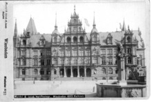

The new town hall was built in 1887. A tile mosaic in front of the town hall shows the heraldic eagle of the Kingdom of Prussia (of which Wiesbaden was a part at the time), the coat of arms of the Prussian Province of Hesse-Nassau, and the fleur-de-lis of Wiesbaden. The old town hall, built in 1610, is the oldest preserved building in the city center and now is used as a civil registry office.
The Protestant Marktkirche ("market church") was built from 1852 to 1862 in a neo-Gothic style. Its western steeple is 92 metres (302 feet) in height, making the church the highest building in the city.
Kurhaus and Theater

The monumental Neo-Classical Kurhaus ("spa house") was built at the request of Kaiser Wilhelm II between 1904 and 1907. Its famous Spielbank (casino) is again in operation.
In front of the Kurhaus is a lawn known as the Bowling Green. To one side of the Bowling Green is the Kurhaus Kolonnade. Built in 1827, the 129 meter structure is the longest hall in Europe supported by pillars. To the other side is the Theater Kolonnade, built in 1839. It is adjacent to the Hessisches Staatstheater Wiesbaden, built between 1892 and 1894.
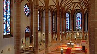
St. Bonifatius
St. Bonifatius, the first church for the Catholic community after the Reformation, was built from 1845 until 1849 by Philipp Hoffmann in Gothic Revival style and dedicated to Saint Boniface.
St. Elizabeth's Church
The Russian Orthodox Church of Saint Elizabeth, called Griechische Kapelle (Greek chapel) locally, was built on the Neroberg from 1847 to 1855 by Duke Adolf of Nassau on the occasion of the early death of his wife Elizabeth Mikhailovna, who died in childbirth. The architect was again Philipp Hoffmann.
Other sights
Another building from the regency of Duke Wilhelm is the Luisenplatz, a square named for the Duke's first wife. It is surrounded by Neoclassicist buildings, and in the middle of the square is the Waterloo Obelisk, commemorating the 683 Nassauers who died on 18 June 1815 near Hougoumont Farm in the respective battle against Napoleon.[18] Apart from the palace in the center, the ducal family had a large palace on the banks of the Rhine, known as Schloss Biebrich. This baroque building was erected in the first half of the 18th century.
North of the city is the Neroberg. From the top of this hill it is possible to view a panorama of the city. The Nerobergbahn funicular railway connects the city with the hill. South of it, the Nerotalanlagen are a park along a creek, created in 1897/98 as an English landscape garden.
One of the three Hessian state museums, Museum Wiesbaden is located in Wiesbaden.
Other churches are the Bergkirche, completed in 1879 in Gothic Revival style, and the Lutherkirche, finished in 1910 in Jugendstil. The church Mariä Heimsuchung is a tall concrete landmark in the Kohlheck suburb.
Oriental Christianity is also represented with the St. Isaiah Syriac Orthodox Church on the Willi-Juppe-Straße in Dotzheim, built 2016 by Suryoye-Assyrians.
The Warmer Damm park is a 4.5-hectare park on the east side of Wilhelmstrasse and south of the State theater and Kurhaus which features a lake, a fountain, various statues, and large grassy areas. The park was created in 1859–1860 and is named after the medieval fortifications around a pond into which the warm waters of the town's 26 warm springs flowed.[19]
Gallery
-
 Biebrich Palace
 -
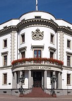 City Palace
 -
 Nerobergbahn funicular
 -
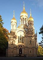 Griechische Kapelle
 -
 Nerotalanlagen
 -
 Marktkirche
 -
 Warmer Damm
 -
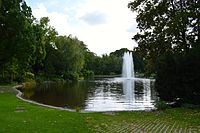 Warmer Damm
 -
 St. Bonifatius


Boroughs of Wiesbaden
The city of Wiesbaden is divided into 26 boroughs: five in the central city and 21 suburban districts. The 21 suburban districts were incorporated in four phases from 1926 to 1977. The former Mainz suburbs on the right bank of river Rhine viz. Amöneburg, Kastel and Kostheim have belonged to Wiesbaden since 1945.
.svg)