A | B | C | D | E | F | G | H | CH | I | J | K | L | M | N | O | P | Q | R | S | T | U | V | W | X | Y | Z | 0 | 1 | 2 | 3 | 4 | 5 | 6 | 7 | 8 | 9
Whitehorse | |
|---|---|
| City of Whitehorse | |
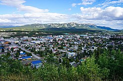
From top to bottom; left to right: View of Central Whitehorse in 2019, northern lights viewed from Riverdale, buildings in Downtown Whitehorse, Yukon Legislative Building | |
|
| |
| Nicknames: | |
| Motto(s): Our People, Our Strength | |
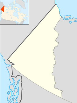
| Coordinates: 60°43′27″N 135°03′22″W / 60.72417°N 135.05611°W[2] | |
| Country | Canada |
| Territory | Yukon |
| Established | 1898 |
| Government | |
| • Mayor | Laura Cabott |
| • Governing body | Whitehorse City Council |
| • MPs | Brendan Hanley |
| • MLAs | Nils Clarke Yvonne Clarke Currie Dixon Scott Kent Jeanie McLean Tracy-Anne McPhee Richard Mostyn Ranj Pillai Elaine Taylor Lane Tredger Kate White |
| Area | |
| • City | 416.54 km2 (160.83 sq mi) |
| • Urban | 34.95 km2 (13.49 sq mi) |
| • Metro | 8,488.91 km2 (3,277.59 sq mi) |
| Elevation | 670–1,702 m (2,200–5,584 ft) |
| Population (2021) | |
| • City | 28,201 |
| • Density | 60.2/km2 (156/sq mi) |
| • Urban | 21,732 |
| • Urban density | 621/km2 (1,610/sq mi) |
| Demonym | Whitehorser[3] |
| Time zone | UTC−07:00 (MST) |
| Forward sortation area | |
| Area code | 867 |
| NTS Map | 105D11 Whitehorse |
| Website | whitehorse |
Whitehorse (French pronunciation: [wajtɔʁs]) is the capital of the Yukon, and the largest city in Northern Canada. It was incorporated in 1950 and is located at kilometre 1426 (Historic Mile 918) on the Alaska Highway in southern Yukon. Whitehorse's downtown and Riverdale areas occupy both shores of the Yukon River, which rises in British Columbia and meets the Bering Sea in Alaska. The city was named after the White Horse Rapids for their resemblance to the mane of a white horse, near Miles Canyon, before the river was dammed.
Because of the city's location in the Whitehorse valley and relative proximity to the Pacific Ocean, the climate is milder than comparable northern communities such as Yellowknife.[4] At this latitude, winter days are short and summer days have up to about 19 hours of daylight.[5][6] Whitehorse, as reported by Guinness World Records, is the city with the least air pollution in the world.[7]
As of the 2021 Canadian census, the population was 28,201[8] within city boundaries and 31,913[9] in the census agglomeration. These figures represent approximately 70 and 79 percent, respectively, of the entire population of Yukon.[10]
History


Archeological research south of the downtown area, at a location known as Canyon City, has revealed evidence of use by First Nations for several thousand years.[11] The surrounding area had seasonal fish camps and Frederick Schwatka, in 1883, observed the presence of a portage trail used to bypass Miles Canyon. Before the Gold Rush, several different tribes passed through the area seasonally and their territories overlapped.[12]
The discovery of gold in the Klondike in August 1896, by Skookum Jim, Tagish Charlie, and George Washington Carmack, set off a major change in the historical patterns of the region. Early prospectors used the Chilkoot Pass, but by July 1897, crowds of neophyte prospectors had arrived via steamship and were camping at "White Horse".[13] By June 1898, there was a bottleneck of prospectors at Canyon City, and many boats had been lost to the rapids as well as five people. Samuel Steele of the North-West Mounted Police remarked: "why more casualties have not occurred is a mystery to me."[14]
On their way to find gold, prospectors also found copper in the "copper belt" in the hills west of Whitehorse. The first copper claims were staked by Jack McIntyre on July 6, 1898, and Sam McGee on July 16, 1899.[15] Two tram lines were built, one 8 km (5.0 mi) stretch on the east bank of the Yukon River from Canyon City to the rapids, just across from the present day downtown, and the other on the west bank of the river.
The White Pass and Yukon Route narrow-gauge railway linking Skagway to Whitehorse had begun construction in May 1898. By May 1899, construction had arrived at the south end of Bennett Lake.[16] Construction began again at the north end of Bennett lake to Whitehorse. It was only in June–July 1900 that construction finished the difficult Bennett Lake section itself, completing the entire route.[17]
By 1901, the Whitehorse Star was already reporting on daily freight volumes. Even though traders and prospectors were all calling the city Whitehorse (White Horse), there was an attempt by the railway people to change the name to Closeleigh (British Close brothers provided funding for the railway), this was refused by William Ogilvie, the territory's Commissioner.
On May 23, 1905, a small fire in the barber shop of the Windsor Hotel got out of control when the fire engine ran out of water, spreading throughout the city and causing $300,000 (equivalent to $10 million in 2023) in damage, though there were no deaths. Robert Service was working as a bank teller at the time and participated in suppressing the flame.[18] The White Horse Restaurant and Inn was among the buildings destroyed, after its co-founder Frederick Trump, the grandfather of Donald Trump, had sold his shares and left the city.[19]
In 1920, the first planes landed in Whitehorse and the first air mail was sent in November 1927. Until 1942, rail, river, and air were the only way to get to Whitehorse, but in 1942 the US military decided an interior road would be safer to transfer troops and provisions between Alaska and the US mainland and began construction of the Alaska Highway.[citation needed] The entire 2,500 km (1,600 mi) project was accomplished between March and November 1942. The Canadian portion of the highway was only returned to Canadian sovereignty after the war. The Canol pipeline was also constructed to supply oil to the north with a refinery in Whitehorse.[citation needed]
In 1950, the city was incorporated and by 1951 the population had doubled from its 1941 numbers. On April 1, 1953, the city was designated the capital of the Yukon Territory when the seat was moved from Dawson City after the construction of the Klondike Highway.[20] On March 21, 1957, the name was officially changed from White Horse to Whitehorse.[21]
Geography

Whitehorse is located at kilometre 1,425 (Historic Mile 918) of the Alaska Highway and is framed by three nearby mountains: Grey Mountain to the east, Mount Sumanik to the northwest and Golden Horn Mountain to the south. The rapids which were the namesake of the city have disappeared under Miles Canyon and Schwatka Lake, formed by the construction of a hydroelectricity dam in 1958. Whitehorse is currently the 64th largest city in Canada by area. The city limits present a near rectangular shape orientated in a NW-SE direction.[22]
Cityscape
Whitehorse Bylaw 426 (1975) restricts the operation of motor vehicles to designated roadways in certain "Protected Areas" to ensure maximum conservation of the environmental quality.[23] Most are near the downtown core (downtown and Yukon river escarpments, Mt. Mac ski trails, Riverdale, Valleyview, Hillcrest, Granger, Porter Creek, and Mountainview) and one, Pineridge, is south of downtown.[24]
In 1999, the city approved the Area Development Scheme (ADS) which reallocated the area previously known as "Whitehorse Copper" to the following uses: Country Residential, Commercial, Service Industrial, and Heavy industrial.
Recent demands for growth have reignited urban planning debates in Whitehorse.[25] In 1970 the Metropolitan Whitehorse development plan included park and greenbelt areas that were to be preserved to ensure high quality of life even within city limits.[26]
Climate
Whitehorse has a subarctic climate (Köppen climate classification: Dfc) and lies in the rain shadow of the Coast Mountains, causing precipitation totals to be quite low year-round. Due to the city's location in the Whitehorse valley, the climate is milder than other comparable northern communities such as Yellowknife, however during cold snaps it is not uncommon for temperatures to drop below −40 °C (−40 °F).[4] With an average annual temperature of 0.2 °C (32.4 °F) Whitehorse is the warmest place in the Yukon. The temperature measurements for the city are taken at the airport. The Whitehorse Riverdale weather station situated at a lower elevation than the airport is also 0.2 °C (32.4 °F).
At this latitude winter days are short and summer days have just over 19 hours of daylight.[6] Whitehorse has an average daily high of 20.6 °C (69.1 °F) in July and average daily low of −19.2 °C (−2.6 °F) in January. The highest temperature ever recorded in Whitehorse was 35.6 °C (96.1 °F) on 14 June 1969.[27] The coldest temperature ever recorded was −56.2 °C (−69.2 °F) on 21 January 1906.[28]
Whitehorse has little precipitation, with an average annual snowfall of 141.8 cm (55.8 in) and 160.9 mm (6.33 in) of rainfall. According to the Meteorological Service of Canada, Whitehorse has the distinction of being Canada's driest city. Whitehorse is in the Cordilleran climate region, the Complex Soils of Mountain Areas soil region, the Cordilleran vegetation region, and the Boreal Cordillera ecozone.
| Climate data for Whitehorse (Erik Nielsen Whitehorse International Airport) WMO ID: 71964; coordinates 60°42′34″N 135°04′07″W / 60.70944°N 135.06861°W; elevation: 706.2 m (2,317 ft); 1991–2020 normals, extremes 1900–present[a] | |||||||||||||
|---|---|---|---|---|---|---|---|---|---|---|---|---|---|
| Month | Jan | Feb | Mar | Apr | May | Jun | Jul | Aug | Sep | Oct | Nov | Dec | Year |
| Record high humidex | 9.5 | 11.1 | 11.7 | 21.6 | 33.6 | 33.3 | 33.6 | 31.9 | 25.2 | 19.0 | 11.1 | 9.2 | 33.6 |
| Record high °C (°F) | 10.9 (51.6) |
11.7 (53.1) |
16.8 (62.2) |
21.8 (71.2) |
34.1 (93.4) |
34.4 (93.9) |
33.2 (91.8) |
31.6 (88.9) |
26.7 (80.1) |
19.3 (66.7) |
13.3 (55.9) |
10.6 (51.1) |
34.4 (93.9) |
| Mean maximum °C (°F) | 2.1 (35.8) |
3.3 (37.9) |
6.7 (44.1) |
14.9 (58.8) |
21.3 (70.3) |
26.4 (79.5) |
27.4 (81.3) |
26.5 (79.7) |
18.9 (66.0) |
12.8 (55.0) |
3.9 (39.0) |
3.4 (38.1) |
29.4 (84.9) |
| Mean daily maximum °C (°F) | −11.1 (12.0) |
−7.1 (19.2) |
−1.1 (30.0) |
7.1 (44.8) |
14.2 (57.6) |
19.3 (66.7) |
20.5 (68.9) |
18.5 (65.3) |
12.3 (54.1) |
4.3 (39.7) |
−5.4 (22.3) |
−9.1 (15.6) |
5.2 (41.4) |
| Daily mean °C (°F) | −15.0 (5.0) |
−11.9 (10.6) |
−6.7 (19.9) |
1.6 (34.9) |
7.9 (46.2) |
12.8 (55.0) |
14.5 (58.1) |
12.9 (55.2) |
7.5 (45.5) |
0.9 (33.6) |
−8.6 (16.5) |
−12.8 (9.0) |
0.2 (32.4) |
| Mean daily minimum °C (°F) | −18.9 (−2.0) |
−16.6 (2.1) |
−12.4 (9.7) |
−4.0 (24.8) |
1.6 (34.9) |
6.2 (43.2) |
8.5 (47.3) |
7.2 (45.0) |
2.7 (36.9) |
−2.8 (27.0) |
−11.8 (10.8) |
−16.5 (2.3) |
−4.7 (23.5) |
| Mean minimum °C (°F) | −37.3 (−35.1) |
−33.0 (−27.4) |
−28.5 (−19.3) |
−15.7 (3.7) |
−5.0 (23.0) |
−0.5 (31.1) |
2.7 (36.9) |
−0.2 (31.6) |
−5.5 (22.1) |
−16.0 (3.2) |
−26.6 (−15.9) |
−34.1 (−29.4) |
−41.3 (−42.3) |
| Record low °C (°F) | −56.2 (−69.2) |
−51.1 (−60.0) |
−42.2 (−44.0) |
−30.6 (−23.1) |
−12.9 (8.8) |
−6.1 (21.0) |
−2.2 (28.0) |
−8.3 (17.1) |
−19.4 (−2.9) |
−31.1 (−24.0) |
Zdroj:https://en.wikipedia.org?pojem=Whitehorse,_Yukon_Territory|||


