A | B | C | D | E | F | G | H | CH | I | J | K | L | M | N | O | P | Q | R | S | T | U | V | W | X | Y | Z | 0 | 1 | 2 | 3 | 4 | 5 | 6 | 7 | 8 | 9
Upper Peninsula of Michigan | |
|---|---|
| Nickname: The U.P. | |
 | |
| Coordinates: 46°14′00″N 86°21′00″W / 46.23333°N 86.35000°W | |
| Country | |
| State | |
| Largest city | Marquette |
| Area | |
| • Total | 36,139 sq mi (93,600 km2) |
| • Land | 16,378 sq mi (42,420 km2) |
| • Water | 19,761 sq mi (51,180 km2) 54.7% |
| Population (2020)[2] | |
| • Total | 301,609 |
| • Density | 8.3/sq mi (3.2/km2) |
| Demonym | Yooper |
| Time zones | |
| Most of the Upper Peninsula | UTC−05:00 (Eastern) |
| • Summer (DST) | UTC−04:00 (EDT) |
| Counties bordering Wisconsin | UTC−06:00 (Central) |
| • Summer (DST) | UTC−05:00 (CDT) |
| Area code | 906[a] |
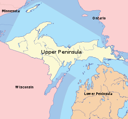
The Upper Peninsula of Michigan—also known as Upper Michigan or colloquially the U.P.—is the northern and more elevated of the two major landmasses that make up the U.S. state of Michigan; it is separated from the Lower Peninsula by the Straits of Mackinac. It is bounded primarily by Lake Superior to the north, separated from the Canadian province of Ontario at the east end by the St. Marys River, and flanked by Lake Huron and Lake Michigan along much of its south. Although the peninsula extends as a geographic feature into the state of Wisconsin, the state boundary follows the Montreal and Menominee rivers and a line connecting them.
First inhabited by Algonquian-speaking native American tribes, the area was explored by French colonists, then occupied by British forces, before being ceded to the newly established United States in the late 18th century. After being assigned to various territorial jurisdictions, it was granted to the newly formed state of Michigan as part of the settlement of a dispute with Ohio over the city of Toledo. The region's exploitable timber resources and the discovery of iron and copper deposits in the 19th century brought immigrants, especially French Canadian, Finnish, Swedish, Cornish, and Italian (the peninsula includes the only counties in the United States where a plurality of residents claim Finnish ancestry).[3] With the exhaustion of readily available minerals, the area's economy declined in the 20th century, largely becoming dependent on logging and tourism.
The Upper Peninsula contains 29% of the land area of Michigan but only 3% of its total population; at the height of the mining and timber era in the early 20th century it had as much as 11% of the state's population. Residents are nicknamed Yoopers (derived from "UP-ers") and have a strong regional identity, enhanced by the perception that the rest of the state neglects them. Proposals have been made to establish the UP as a separate state but have failed to gain traction. Its largest cities are Marquette, Sault Ste. Marie, Escanaba, Menominee, Houghton, and Iron Mountain. Because of the surrounding waters and northern latitude, it receives more snow than most of the eastern U.S. The heavily forested land, soil types, short growing season, and logistical factors (e.g. long distance to market, lack of infrastructure) make the Upper Peninsula poorly suited for agriculture. The region is home to a variety of wildlife, including moose, wolves, coyotes, deer, foxes, bears, mountain lions, bobcats, eagles, hawks, and owls.
History

The first known inhabitants of the Upper Peninsula were tribes speaking Algonquian languages, specifically the Algonquian branches of Ojibway and Menominee. They arrived roughly around 800 C.E. and subsisted chiefly from fishing. Early tribes included the Menominee, Odawa, Ojibwa, Nocquet, and Potawatomi. Étienne Brûlé of France was probably the first European to visit the peninsula, crossing the St. Marys River around 1620 in search of a route to the Far East.[4] French colonists laid claim to the land in the 17th century, establishing missions and fur trading posts such as Sault Ste. Marie and St. Ignace. Following the end of the French and Indian War (part of the Seven Years' War) in 1763, the territory was ceded to Great Britain. Sault Ste. Marie is the oldest European settlement in Michigan and the site of Native American settlements for centuries.
American Indian tribes formerly allied with the French were dissatisfied with the British occupation, which brought new territorial policies. Whereas the French cultivated alliances among the Indians, the British postwar approach was to treat the tribes as conquered peoples. In 1763, tribes united in Pontiac's Rebellion to try to drive the British from the area. American Indians captured Fort Michilimackinac, at present-day Mackinaw City, then the principal fort of the British in the Michilimackinac region, as well as others and killed hundreds of British. In 1764, they began negotiations with the British, resulting in temporary peace and changes in objectionable British policies.
Although the Upper Peninsula nominally became United States territory with the 1783 Treaty of Paris, the British did not give up control until 1797 under terms of the Jay Treaty. As an American territory, the Upper Peninsula was still dominated by the fur trade. John Jacob Astor founded the American Fur Company on Mackinac Island in 1808; however, the industry began to decline in the 1830s as beaver and other game were overhunted.[5]
When the Michigan Territory was first established in 1805, it included only the Lower Peninsula and the eastern portion of the Upper Peninsula. In 1819, the territory was expanded to include the remainder of the Upper Peninsula, all of what later became Wisconsin, and part of Minnesota (previously included in the Indiana and Illinois Territories). When Michigan applied for statehood in the 1830s, the proposal corresponded to the original territorial boundaries. However, there was an armed conflict known as the Toledo War with the state of Ohio over the location of their mutual border. Meanwhile, the people of Michigan approved a constitution in May 1835 and elected state officials in late autumn 1835. Although the state government was not yet recognized by the United States Congress, the territorial government effectively ceased to exist. President Andrew Jackson's government offered the remainder of the Upper Peninsula to Michigan if it would cede the Toledo Strip to Ohio. A constitutional convention of the state legislature refused, but a second convention, hastily convened by Governor Stevens Thomson Mason, consisting primarily of his supporters, agreed in December 1836 to the deal. In January 1837, the U.S. Congress admitted Michigan as a state of the Union.

At the time, Michigan was considered the losing party in the compromise. The land in the Upper Peninsula was described in a federal report as a "sterile region on the shores of Lake Superior destined by soil and climate to remain forever a wilderness."[4] This belief changed when rich mineral deposits (primarily copper and iron) were discovered in the 1840s. The Upper Peninsula's mines produced more mineral wealth than the California Gold Rush, especially after shipping was improved by the opening of the Soo Locks in 1855 and docks in Marquette in 1859. The Upper Peninsula supplied 90% of America's copper by the 1860s. It was the nation's largest supplier of iron ore by the 1890s, and production continued to a peak in the 1920s but sharply declined shortly afterward. The last copper mine closed in 1995, although the majority of mines had closed decades before. Some iron mining continues near Marquette.[4] The Eagle Mine, a nickel-copper mine, opened in 2014.[6]
Thousands of Americans and immigrants moved to the area during the mining boom, prompting the federal government to create Fort Wilkins near Copper Harbor to maintain order. The first wave were the Cornish from Great Britain, with centuries of mining experience; followed by Irish, Germans, and French Canadians. During the 1890s, Finnish immigrants began settling there in large numbers, forming the population plurality in the northwestern portion of the peninsula. In the early 20th century, 75% of the population was foreign-born.[5]
From 1861 to 1865, 90,000 Michigan men fought in the American Civil War, including 1,209 from the Upper Peninsula. Houghton County contributed 460 soldiers, while Marquette County sent 265.[7]
Geography


Including extensive parts of the Great Lakes, the Upper Peninsula contains about 36,139 square miles (93,600 km2) of total area. Of that, about 16,378 square miles (42,420 km2) is its land area,[1] about 29% of the state.[citation needed] It is bounded on the north by Lake Superior, on the east by St. Marys River, on the south by Lake Michigan and Lake Huron, and on the west by Wisconsin and (counting the water border on Lake Superior) by Minnesota. It has about 1,700 miles (2,700 km) of continuous shoreline with the Great Lakes. There are about 4,300 inland lakes, the largest of which is Lake Gogebic, and 12,000 miles (19,000 km) of streams.[8] Its lowest elevation is along the shoreline of Lake Huron and Lake Michigan, averaging 577 feet (176 m) above sea level.[9] Its highest elevation is Mount Arvon, at 1,979 feet (603 m).[10]
Michigan's Upper Peninsula is bounded on land by Wisconsin to the southwest and west; and in territorial waters by Minnesota to the west, Ontario to the west, north and east, and the Door Peninsula of Wisconsin extends into Lake Michigan east of the western Upper Peninsula.
Five Michigan Upper Peninsula counties include nearby major islands: Mackinac Island, Round Island and Bois Blanc Island in Lake Huron are in Mackinac County; Sugar Island and Neebish Island in the St. Marys River, and Drummond Island in Lake Huron are in Chippewa County; Grand Island is in Alger County; Summer Island is Delta County; and Isle Royale is part of Keweenaw County.The peninsula is divided between the flat, swampy areas in the east, part of the Great Lakes Plain, and the steeper, more rugged western half, called the Superior Upland, part of the Canadian Shield.[11] The rock in the western portion is the result of volcanic eruptions and is estimated to be at least 3.5 billion years old (much older than the eastern portion) and contains the region's ore resources. Banded-iron formations were deposited 2 billion years ago; this is the Marquette Range Supergroup. A considerable amount of bedrock is visible. Mount Arvon is within the Huron Mountains, located in Marquette and Baraga counties. The Porcupine Mountains are located in the extreme northwest of the peninsula. All of the higher areas are the remnants of ancient peaks, worn down over millions of years by erosion and glaciers.[12]
The Keweenaw Peninsula is the northernmost part of the peninsula (not counting Isle Royale, which is politically part of the UP). It projects into Lake Superior and was the site of the first copper boom in the United States, part of a larger region of the peninsula called the Copper Country.[13] Copper Island is its northernmost section. About one-third of the peninsula is government-owned recreational forest land today, including the Ottawa National Forest and Hiawatha National Forest. Although heavily logged in the 19th century, the majority of the land was forested with mature trees by the 1970s.[4]
There was a boundary dispute over the border with Wisconsin. The northwesternmost portion of the border follows a line from Lac Vieux Desert to the headwaters of the Montreal River. An 1847 survey established the east branch of the Montreal River as the border. However, the 1908 revision of the Constitution of Michigan specified that the west branch of the Montreal River was the proper border, which would have placed an additional 360 square miles of land on the Michigan side of the border.[14] A 1926 Supreme Court decision awarded this tract of land to Wisconsin.[15]
Wildlife
The Upper Peninsula contains a large variety of wildlife. Some of the mammals found in the UP include shrews, moles, mice, white-tailed deer, moose, black bears, cougar, gray and red foxes, wolves, river otters, martens, fishers, muskrats, bobcats, coyotes, snowshoe hares, cotton-tail rabbits, porcupines, chipmunks, squirrels, raccoons, opossum and bats. There is a large variety of birds, including hawks, osprey, owls, gulls, hummingbirds, chickadees, robins (the state bird), woodpeckers, warblers, and bald eagles. In terms of reptiles and amphibians, the UP has common garter snakes, red bellied snakes, pine snakes, northern water snakes, brown snakes, eastern garter snakes, eastern fox snakes, eastern ribbon back snakes, green snakes, northern ringneck snakes, eastern milk snakes (Mackinac and Marquette counties) and eastern hognose snakes (Menominee County only), plus snapping turtles, wood turtles, and painted turtles (the state reptile), green frogs, bullfrogs, northern leopard frogs, and salamanders. Lakes and rivers contain many fish such as walleye, muskie, northern pike, trout, salmon, bullhead catfish, and bass. Invasive species like the alewife and sea lamprey can be found in the Great Lakes. The UP also contains many shellfish, such as clams, aquatic snails, and crayfish. The American Bird Conservancy and the National Audubon Society have designated several locations as internationally Important Bird Areas.[16]

After being nearly extirpated from the conterminous United States, gray wolves survived in the remote northeastern corner of Minnesota and Ontario. The repopulation of wolves in this region has occurred naturally as they have expanded their territory.
There is significant discussion and studies over the presence of eastern cougars in the UP.[17] Historically, the last of the species, or subspecies, was extirpated near Newberry in 1906, although there have been sightings of the creatures over the years since.[18][19] These reports increased in number over the first decade of the 21st century. The Michigan Department of Natural Resources and Environment (DNRE)[b] formed a four-person team to investigate sightings in the state. The biologists with the DNRE currently do not believe that there is a breeding population anywhere in the state, rather that the sighted animals are visitors to the state.[21] As late as January 2007, the DNRE's official position was that no cougars lived in Michigan.[22] Several residents in the state disagree with both current and previous positions on the part of the DNRE.[22][23] Researchers at Central Michigan University and the Michigan Wildlife Conservancy in 2006 published the findings of a study using DNA analysis of fecal samples taken in the Upper and Lower peninsulas that showed the presence of cougars at the time.[24] These results were disputed in a second journal article in 2007 by other researchers from Eastern Michigan University and the U.S. Forest Service.[25] A citizen's group, the Michigan Citizens for Cougar Recognition (MCCR), independently tracked sightings and in 2009 listed Delta County as the location with the greatest number of reports in the state.[26] The DNRE verified five sets of tracks and two trail camera photos in Delta, Chippewa, Marquette, and Menominee counties since 2008.[27] DNRE officials acknowledge that there are cougars in the UP, but not elsewhere in the state. Critics of the DNRE's position on the species, including the founder of the MCCR, say that the department is attempting to "avoid paying for a cougar management program".[23]
There also many invasive species that are primarily brought in the ballast water of foreign ships, usually from the ocean bordering northeastern Asia. This water is dumped directly into the Great Lakes, depositing a variety of fresh and salt water fish and invertebrates, most notably the zebra mussel, Dreissena polymorpha. There are also many plant species that have been transported to the Great Lakes, including purple loosestrife, Lythrum salicaria[28] and Phragmites australis, both of which are considered to be a threat to native hydrophyte wetland plants.[29][30] The emerald ash borer was first reported in the UP at Brimley State Park[31] and is considered to be a serious ecological threat to the habitat and economy.
Climate

The Upper Peninsula has a humid continental climate (Dfb in the Köppen climate classification system). The Great Lakes have a great effect on the larger part of the peninsula. Winters tend to be long, cold, and snowy for most of the peninsula, and because of its northern latitude, the daylight hours are short—around 8 hours between sunrise and sunset in the winter. Lake Superior has the greatest effect on the area, especially the northern and western parts. Lake-effect snow causes many areas to get in excess of 100–250 inches (2.5–6.4 m) of snow per year—especially in the Keweenaw Peninsula and Gogebic County, and to a lesser extent Baraga, Marquette and Alger counties, making the western UP a prominent part of the midwestern snowbelt.
Records of 390 inches (9.9 m) of snow or more have been set in many communities in this area.[32] The Keweenaw Peninsula averages more snowfall than any other location east of the Mississippi River.[33] Because of the howling storms across Lake Superior, which cause dramatic amounts of precipitation, it has been said that the lake-effect snow makes the Keweenaw Peninsula the snowiest place east of the Rockies. Herman averages 236 inches (5.99 m) of snow every year.[34] Lake-effect snow can cause blinding whiteouts in just minutes, and some storms can last for days. Hancock is found frequently on lists of the snowiest cities in America.[35]
The banana belt along the Wisconsin border has a more continental climate since most of its weather does not arrive from the lakes. Summers tend to be warmer and winter nights much colder. Coastal communities have temperatures tempered by the Great Lakes. In summer, it might be 10 °F (5.6 °C) cooler at lakeside than it is inland, and the opposite effect is seen in winter. The area of the Upper Peninsula north of Green Bay through Menominee and Escanaba (and extending west to Iron River) does not have the extreme weather and precipitation found to the north.[4] The coldest temperature officially recorded in the Upper Peninsula was −48 °F (−44 °C) in Humboldt in January 1915.[36]
Time zones
Like the entire Lower Peninsula, most of the Upper Peninsula is within the Eastern Time Zone. However, the four counties bordering Wisconsin are in the Central Time Zone. In 1967, when the Uniform Time Act came into effect, the Upper Peninsula went under year-round Central Standard Time, with no daylight saving time.[37] In 1973, the majority of the peninsula switched to Eastern Standard Time;[38] only the four western border counties of Gogebic, Iron, Dickinson, and Menominee continue to observe Central Standard Time. Daylight saving time is observed peninsula-wide.
Demographics
The Upper Peninsula remains a predominantly rural region. As of the 2020 census the region had a population of 301,608, just more than 3% of Michigan's total population and a decline of 3.2% from 2010.[2]
According to the 2010 census, 103,211 people live in the 12 towns of at least 4,000 people, covering 96.5 square miles (250 km2). A total of 116,548 people live in the 18 towns and villages of at least 2,000 people, which cover 108.5 square miles (281 km2)—less than 1% of the peninsula's land area.
|
|


