

A | B | C | D | E | F | G | H | CH | I | J | K | L | M | N | O | P | Q | R | S | T | U | V | W | X | Y | Z | 0 | 1 | 2 | 3 | 4 | 5 | 6 | 7 | 8 | 9
Oklahoma
Oklahumma (Choctaw) | |
|---|---|
| State of Oklahoma | |
Nicknames:
| |
| Motto(s): | |
| Anthem: "Oklahoma" and "Oklahoma Hills" | |
 Map of the United States with Oklahoma highlighted | |
| Country | United States |
| Before statehood |
|
| Admitted to the Union | November 16, 1907 (46th) |
| Capital (and largest city) | Oklahoma City |
| Largest county or equivalent | Oklahoma |
| Largest metro and urban areas | Greater Oklahoma City |
| Government | |
| • Governor | Kevin Stitt (R) |
| • Lieutenant Governor | Matt Pinnell (R) |
| Legislature | Oklahoma Legislature |
| • Upper house | Senate |
| • Lower house | House of Representatives |
| Judiciary | Oklahoma Supreme Court (civil) Oklahoma Court of Criminal Appeals (criminal) |
| U.S. senators |
|
| U.S. House delegation | 5 Republicans (list) |
| Area | |
| • Total | 69,898 sq mi (181,038 km2) |
| • Land | 68,595 sq mi (177,660 km2) |
| • Water | 1,304 sq mi (3,377 km2) 1.9% |
| • Rank | 20th |
| Dimensions | |
| • Length | 468 mi (756 km) |
| • Width | 230 mi (370 km) |
| Elevation | 1,300 ft (400 m) |
| Highest elevation | 4,975 ft (1,516 m) |
| Lowest elevation | 289 ft (88 m) |
| Population (2023) | |
| • Total | 4,053,824 |
| • Rank | 28th |
| • Density | 55.20/sq mi (21.30/km2) |
| • Rank | 35th |
| • Median household income | $50,051[2] |
| • Income rank | 43rd |
| Demonym(s) | Oklahoman; Okie (colloq., historically derogatory); Sooner (historically) |
| Language | |
| • Official language | English, Choctaw, Cherokee[b][3][4][5] |
| Time zones | |
| entire state (legally) | UTC−06:00 (Central) |
| • Summer (DST) | UTC−05:00 (CDT) |
| Kenton (informally) | UTC−07:00 (Mountain) |
| • Summer (DST) | UTC−06:00 (MDT) |
| USPS abbreviation | OK |
| ISO 3166 code | US-OK |
| Traditional abbreviation | Okla. |
| Latitude | 33°37' N to 37° N |
| Longitude | 94° 26' W to 103° W |
| Website | oklahoma |


Oklahoma (/ˌoʊkləˈhoʊmə/ OHK-lə-HOH-mə;[6] Choctaw: Oklahumma, pronounced [oklahómma])[7] is a landlocked state in the South Central region of the United States.[8] It borders Texas to the south and west, Kansas to the north, Missouri to the northeast, Arkansas to the east, New Mexico to the west, and Colorado to the northwest. Partially in the western extreme of the Upland South, it is the 20th-most extensive and the 28th-most populous of the 50 United States. Its residents are known as Oklahomans and its capital and largest city is Oklahoma City. The state's name is derived from the Choctaw words okla, 'people' and humma, which translates as 'red'.[9] Oklahoma is also known informally by its nickname, "The Sooner State", in reference to the Sooners, American settlers who staked their claims in formerly American Indian-owned lands until the Indian Appropriations Act of 1889 authorized the Land Rush of 1889 opening the land to settlement.
With ancient mountain ranges, prairie, mesas, and eastern forests, most of Oklahoma lies in the Great Plains, Cross Timbers, and the U.S. Interior Highlands, all regions prone to severe weather.[10] Oklahoma is at a confluence of three major American cultural regions. Historically, it served as a government-sanctioned territory for American Indians moved from east of the Mississippi River, a route for cattle drives from Texas and related regions, and a destination for Southern settlers. There are currently 26 Indigenous languages spoken in Oklahoma.[11] According to the 2020 U.S. census, 14.2 percent of Oklahomans identify as American Indians, the highest indigenous population by percentage in any state.[12]
A major producer of natural gas, oil, and agricultural products, Oklahoma relies on an economic base of aviation, energy, telecommunications, and biotechnology.[13] Oklahoma City and Tulsa serve as Oklahoma's primary economic anchors, with nearly two-thirds of Oklahomans living within their metropolitan statistical areas.[14]
Etymology
The name Oklahoma comes from the Choctaw language phrase okla, 'people', and humma, translated as 'red'.[9][15] Choctaw Nation Chief Allen Wright suggested the name in 1866 during treaty negotiations with the federal US government on the use of Indian Territory. He envisioned an all exclusive American Indian state controlled by the United States bureau of Indian Affairs. Oklahoma later became the de facto name for Oklahoma Territory, and it was officially approved in 1890, two years after that area was opened to American settlers.[16][17][18]
History
Pre-Columbian
Indigenous peoples were present in what is now Oklahoma by the last ice age.[19] Ancestors of the Wichita and Affiliated Tribes (including Teyas and Escanjaques and Tawakoni), Tonkawa,[20] and Caddo (including Kichai) lived in what is now Oklahoma. Southern Plains villagers lived in the central and west of the state, with a subgroup, the Panhandle culture people, living in the panhandle region. Caddoan Mississippian culture peoples lived in the eastern part of the state. Spiro Mounds, in what is now Spiro, Oklahoma, was a major Mississippian mound complex that flourished between AD 850 and 1450.[21][22] Plains Apache people settled in the Southern Plains and in Oklahoma between 1300 and 1500.[23]
European exploration and colonization
The expedition of Spaniard Francisco Vázquez de Coronado traveled through the state in 1541,[24] but French explorers claimed the area in the early 18th century.[25] By the 18th century, Comanche and Kiowa entered the region from the west and Quapaw and Osage peoples moved into what is now eastern Oklahoma. French colonists claimed the region until 1803, when all the French territory west of the Mississippi River was acquired by the United States in the Louisiana Purchase.[24] The territory was a part of the Arkansas Territory from 1819 until 1828.[26]
19th century
During the 19th century, the U.S. federal government forcibly removed tens of thousands of American Indians from their ancestral homelands from across North America and transported them to the area including and surrounding present-day Oklahoma. The Choctaw was the first of the Five Civilized Tribes to be removed from the Southeastern United States. The phrase "Trail of Tears" originated from a description of the removal of the Choctaw Nation in 1831, although the term is usually used for the Cherokee removal.[27]
Seventeen thousand Cherokees and 2,000 of their black slaves were deported.[28] The area, already occupied by Osage and Quapaw tribes, was called for the Choctaw Nation until revised Native American and then later American policy redefined the boundaries to include other Native Americans. By 1890, more than 30 Native American nations and tribes had been concentrated on land within Indian Territory or "Indian Country".[29]
All Five Civilized Tribes supported and signed treaties with the Confederate military during the American Civil War.[30] The Cherokee Nation had an internal civil war.[31] Slavery in Indian Territory was not abolished until 1866.[32]
In the period between 1866 and 1899,[24] cattle ranches in Texas strove to meet the demands for food in eastern cities and railroads in Kansas promised to deliver in a timely manner. Cattle trails and cattle ranches developed as cowboys either drove their product north or settled illegally in Indian Territory.[24] In 1881, four of five major cattle trails on the western frontier traveled through Indian Territory.[33]

Increased presence of white settlers in Indian Territory and their demand for land owned and guaranteed to Indian tribes by treaties with the U.S. government prompted the United States to enact the Dawes Act in 1887 and the Curtis Act of 1898. The acts abolished tribal governments, eliminated tribal ownership of land, and allotted 160 acres (65 ha) of land to each head of an Indian family. An objective of the acts was the forced assimilation of Indians into white society. Land not allotted to individual Indians was owned by the U.S. government and sold or distributed to settlers and railroads. The proceeds of the land sales were used to educate Indian children and advance the policy of assimilation. As a result of the two acts about one-half of land previously owned by Indian tribes was owned by whites by 1900.[34] Moreover, much of the land allotted to individual Indian heads of families became white-owned. Allottees often sold or were fraudulently deprived of their land.[35]
The acquisition of tribal lands by the U.S. government led to land runs, also called "land rushes," from 1887 and 1895. Major land runs, including the Land Rush of 1889, opened up millions of acres of formerly tribal lands to white settlement. The "rushes" began at a precise times as each prospective settler literally raced with other prospective settlers to claim ownership of 160 acres (65 ha) of land under the Homestead Act of 1862. Usually land was claimed by settlers on a first come, first served basis.[36] Those who broke the rules by crossing the border into the territory before the official opening time were said to have been crossing the border sooner, leading to the term sooners, which eventually became the state's official nickname.[37] George Washington Steele was appointed the first governor of the territory of Oklahoma in 1890.
20th century

Attempts to create an all-Indian state named Oklahoma and a later attempt to create an all-Indian state named Sequoyah failed but the Sequoyah Statehood Convention of 1905 eventually laid the groundwork for the Oklahoma Statehood Convention, which took place two years later.[38] On June 16, 1906, Congress enacted a statute authorizing the people of the Oklahoma and Indian Territories (as well what would become the states of Arizona and New Mexico) to form a constitution and state government in order to be admitted as a state.[39] On November 16, 1907, President Theodore Roosevelt issued Presidential Proclamation no. 780, establishing Oklahoma as the 46th state in the Union.[40]
The new state became a focal point for the emerging oil industry, as discoveries of oil pools prompted towns to grow rapidly in population and wealth. Tulsa eventually became known as the "Oil Capital of the World" for most of the 20th century and oil investments fueled much of the state's early economy.[41] In 1927, Oklahoman businessman Cyrus Avery, known as the "Father of Route 66", began the campaign to create U.S. Route 66. Using a stretch of highway from Amarillo, Texas to Tulsa, Oklahoma to form the original portion of Highway 66, Avery spearheaded the creation of the U.S. Highway 66 Association to oversee the planning of Route 66, based in his hometown of Tulsa.[42]
In late September 1918, the first cases of the Spanish flu appeared in Oklahoma. Though public health authorities statewide had some indication that the pandemic was westward, the turmoil caused by the rapid advancement of the disease quickly overwhelmed both health workers and local governing bodies. In Oklahoma City, shortages of both supplies and personnel were mitigated, in part, by the mobilization of the American Red Cross. Rough estimates based on contemporary reports indicate that approximately 100,000 people fell ill with the disease before the pandemic ebbed in 1919. Of those 100,000 cases, it is assumed that around 7,500 proved fatal, placing total mortality rates for the state in the area of 7.5%.[43]
Oklahoma also has a rich African-American history. Many Black towns, founded by the Freedmen of the Five Tribes during Reconstruction, thrived in the early 20th century with the arrival of Black Exodusters who migrated from neighboring states, especially Kansas. The politician Edward P. McCabe encouraged Black settlers to come to what was then Indian Territory. McCabe discussed with President Theodore Roosevelt the possibility of making Oklahoma a majority-Black state.[44]
By the early 20th century, the Greenwood district of Tulsa was one of the most prosperous African-American communities in the United States.[45] Jim Crow laws had established racial segregation since before the start of the 20th century, but Tulsa's Black residents had created a thriving area.[46][47][48]
Social tensions were exacerbated by the revival of the Ku Klux Klan after 1915. The Tulsa race massacre broke out in 1921, with White mobs attacking Black people and carrying out a pogrom in Greenwood. In one of the costliest episodes of racist violence in American history, sixteen hours of rioting resulted in the destruction of 35 city blocks, $1.8 million in property damage, and an estimated death toll of between 75 and 300 people.[49] By the late 1920s, the Ku Klux Klan had declined to negligible influence within the state.[50]

During the 1930s, parts of the state began to suffer from the consequences of poor farming practices. This period was known as the Dust Bowl, throughout which areas of Kansas, Texas, New Mexico, and northwestern Oklahoma were hampered by long periods of little rainfall, strong winds, abnormally high temperatures, and most notably, severe dust storms sending thousands of farmers into poverty and forcing them to relocate to more fertile areas of the western United States.[51] Over a twenty-year period ending in 1950, the state saw its only historical decline in population, dropping 6.9 percent as impoverished families migrated out of the state after the Dust Bowl.
Soil and water conservation projects markedly changed practices in the state and led to the construction of massive flood control systems and dams; they built hundreds of reservoirs and man-made lakes to supply water for domestic needs and agricultural irrigation.[10][52]

In 1995, Oklahoma City was the site of the most destructive act of domestic terrorism in American history. The Oklahoma City bombing of April 19, 1995, in which Timothy McVeigh detonated a large, crude explosive device outside the Alfred P. Murrah Federal Building, killed 168 people, including 19 children. For his crime, McVeigh was executed by the federal government on June 11, 2001. His accomplice, Terry Nichols, is serving life in prison without parole for helping plan the attack and prepare the explosive.[53]
21st century
On May 31, 2016, several cities experienced record setting flooding.[54][55]

On July 9, 2020, the Supreme Court of the United States determined in McGirt v. Oklahoma that the reservations of the Five Tribes, comprising much of Eastern Oklahoma, were never disestablished by Congress and thus are still "Indian Country" for the purposes of criminal law.[56]
Later decisions by the Oklahoma Court of Criminal Appeals also found the Quapaw Nation,[57] Ottawa Tribe, Peoria Tribe, and Miami Tribe[58] also had existing reservations. The Osage Nation is awaiting for a possible appellate decision after a district judge had ruled that the Osage reservation was disestablished.[59]
Geography

Oklahoma is the 20th-largest state in the United States, covering an area of 69,895 square miles (181,030 km2), with 68,591 square miles (177,650 km2) of land and 1,304 square miles (3,380 km2) of water.[60] It lies partly in the Great Plains near the geographical center of the 48 contiguous states. It is bordered on the east by Arkansas and Missouri, on the north by Kansas, on the northwest by Colorado, on the far west by New Mexico, and on the south and near-west by Texas.
Borders
Oklahoma's border with Kansas was defined as the 37th Parallel in the 1854 Kansas-Nebraska Act. This was disputed with the Cherokee and Osage Nations, which claimed their border extended North of this line and could not be part of the Kansas Territory. This was resolved in 1870 with the Drum Creek Treaty, which reestablished Kansas's southern border as the 37th parallel. This also applied to the then No-Man's Land that became the Oklahoma Panhandle.
The Oklahoma-Texas border consists of the Red River of the South in the south and the 100th meridian west as the western border between Oklahoma and the Texas Panhandle. These were first established in the 1819 Adams–Onís Treaty between the United States and Spain.
The Oklahoma panhandle was originally part of the Panhandle of the Republic of Texas, but when Texas joined the Union as a slave state, it could not retain any lands north of 36 degrees 30 minutes, as specified in the Missouri Compromise. The Panhandle existed as a no-man's land until 1907 when Oklahoma acquired the territory upon gaining statehood.
Oklahoma's Eastern border is divided between Missouri and Arkansas. The Missouri-Oklahoma border is defined as the Meridian passing through the Kawsmouth,[61] where the Kansas River meets the Missouri River. This is the same Meridian as the Kansas-Missouri border.
The Oklahoma-Arkansas border was originally defined by two lines: the borders between Arkansas and the Cherokee and Choctaw Reservations. This formed two diagonal lines meeting at the western edge of Fort Smith Arkansas, with one line running northeast from the Red River and the other running southeast from the Oklahoma-Arkansas-Missouri border. The Choctaw-Arkansas border was established in the 1820 Treaty of Doak's Sand, and later refined in the 1830 Treaty of Dancing Rabbit Creek. These treaties left a 57-acre exclave of the Choctaw reservation bounded by Arkansas, the Arkansas River and the Poteau River. This became the site of a smuggling camp called "Coke Hill", noted mostly for its importance in cocaine smuggling.[62]
After Petitioning congress to hand over jurisdiction, the 57 acres was given to Arkansas in 1905. The 1985 US Supreme Court Case Oklahoma v. Arkansas decided the land would remain Arkansas, even though the Choctaw had not been notified or asked about the territory being handed over.[63] Therefore, the Poteau River serves as the Oklahoma-Arkansas boundary for approximately 1 mile, reducing the Choctaw Reservation and later Oklahoma by 57 acres as established in the treaties of the early 1800s.
Topography
Oklahoma is between the Great Plains and the Ozark Plateau in the Gulf of Mexico watershed,[64] generally sloping from the high plains of its western boundary to the low wetlands of its southeastern boundary.[65][66] Its highest and lowest points follow this trend, with its highest peak, Black Mesa, at 4,973 feet (1,516 m) above sea level, situated near its far northwest corner in the Oklahoma Panhandle. The state's lowest point is on the Little River near its far southeastern boundary near the town of Idabel, which dips to 289 feet (88 m) above sea level.[67]
Among the most geographically diverse states, Oklahoma is one of four to harbor more than 10 distinct ecological regions, with 11 in its borders—more per square mile than in any other state.[10] Its western and eastern halves, however, are marked by extreme differences in geographical diversity: Eastern Oklahoma touches eight ecological regions and its western half contains three. Although having fewer ecological regions Western Oklahoma contains many rare, relic species.[10]
Oklahoma has four primary mountain ranges: the Ouachita Mountains, the Arbuckle Mountains, the Wichita Mountains, and the Ozark Mountains.[65] Contained within the U.S. Interior Highlands region, the Ozark and Ouachita Mountains are the only major mountainous region between the Rocky Mountains and the Appalachians.[68] A portion of the Flint Hills stretches into north-central Oklahoma, and near the state's eastern border, The Oklahoma Tourism & Recreation Department regards Cavanal Hill as the world's tallest hill; at 1,999 feet (609 m), it fails their definition of a mountain by one foot.[69]
The semi-arid high plains in the state's northwestern corner harbor few natural forests; the region has a rolling to flat landscape with intermittent canyons and mesa ranges like the Glass Mountains. Partial plains interrupted by small, sky island mountain ranges like the Antelope Hills and the Wichita Mountains dot southwestern Oklahoma; transitional prairie and oak savannas cover the central portion of the state. The Ozark and Ouachita Mountains rise from west to east over the state's eastern third, gradually increasing in elevation in an eastward direction.[66][70]
More than 500 named creeks and rivers make up Oklahoma's waterways, and with 200 lakes created by dams, it holds the nation's highest number of artificial reservoirs.[69] Most of the state lies in two primary drainage basins belonging to the Red and Arkansas Rivers, though the Lee and Little Rivers also contain significant drainage basins.[70]
-
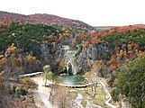 Turner Falls
 -
 State rock (rose rock) specimens from Cleveland County
 -
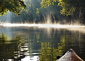
 Illinois River in northeastern Oklahoma
 -
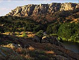 Elk Mountain, in the eastern Wichita Mountains, southwestern Oklahoma
 -
 Wichita Mountains Narrows
 -
 The Ouachita Mountains cover much of southeastern Oklahoma.
 -
 Grave Creek in McIntosh County
 -
 Mesas rise above one of Oklahoma's state parks.


.jpg)

Flora and fauna

Due to Oklahoma's location at the confluence of many geographic regions, the state's climatic regions have a high rate of biodiversity. Forests cover 24 percent of Oklahoma[69] and prairie grasslands composed of shortgrass, mixed-grass, and tallgrass prairie, harbor expansive ecosystems in the state's central and western portions, although cropland has largely replaced native grasses.[71] Where rainfall is sparse in the state's western regions, shortgrass prairie and shrublands are the most prominent ecosystems, though pinyon pines, red cedar (junipers), and ponderosa pines grow near rivers and creek beds in the panhandle's far western reaches.[71] Southwestern Oklahoma contains many rare, disjunct species, including sugar maple, bigtooth maple, nolina, and Texas live oak.[72]
Marshlands, cypress forests, and mixtures of shortleaf pine, loblolly pine, blue palmetto, and deciduous forests dominate the state's southeastern quarter, while mixtures of largely post oak, elm, red cedar (Juniperus virginiana), and pine forests cover northeastern Oklahoma.[70][71][73]
The state holds populations of white-tailed deer, mule deer, antelope, coyotes, mountain lions, bobcats, elk, and birds such as quail, doves, cardinals, bald eagles, red-tailed hawks, and pheasants. In prairie ecosystems, American bison, greater prairie chickens, badgers, and armadillo are common, and some of the nation's largest prairie dog towns inhabit shortgrass prairie in the state's panhandle. The Cross Timbers, a region transitioning from prairie to woodlands in Central Oklahoma, harbors 351 vertebrate species. The Ouachita Mountains are home to black bear, red fox, gray fox, and river otter populations, which coexist with 328 vertebrate species in southeastern Oklahoma. Also in southeastern Oklahoma lives the American alligator.[71]
Protected lands
Oklahoma has fifty-one state parks,[74] six national parks or protected regions,[75] two national protected forests or grasslands,[76] and a network of wildlife preserves and conservation areas. Six percent of the state's 10 million acres (40,000 km2) of forest is public land,[73] including the western portions of the Ouachita National Forest, the largest and oldest national forest in the Southern United States.[77]
With 39,000 acres (160 km2), the Tallgrass Prairie Preserve in north-central Oklahoma is the largest protected area of tallgrass prairie in the world and is part of an ecosystem that encompasses only ten percent of its former land area, once covering fourteen states.[78] In addition, the Black Kettle National Grassland covers 31,300 acres (127 km2) of prairie in southwestern Oklahoma.[79] The Wichita Mountains Wildlife Refuge is the oldest and largest of nine National Wildlife Refuges in the state[80] and was founded in 1901, encompassing 59,020 acres (238.8 km2).[81]
Of Oklahoma's federally protected parks or recreational sites, the Chickasaw National Recreation Area is the largest, with 9,898.63 acres (40.0583 km2).[82] Other sites include the Santa Fe and Trail of Tears national historic trails, the Fort Smith and Washita Battlefield national historic sites, and the Oklahoma City National Memorial.[75]
Climate


Oklahoma is in a humid subtropical region[83] that lies in a transition zone between semiarid further to the west, humid continental to the north, and humid subtropical to the east and southeast. Most of the state lies in an area known as Tornado Alley characterized by frequent interaction between cold, dry air from Canada, warm to hot, dry air from Mexico and the Southwestern U.S., and warm, moist air from the Gulf of Mexico. The interactions between these three contrasting air currents produces severe weather (severe thunderstorms, damaging thunderstorm winds, large hail and tornadoes) with a frequency virtually unseen anywhere else on planet Earth.[67] An average 62 tornadoes strike the state per year—one of the highest rates in the world.[84]
Because of Oklahoma's position between zones of differing prevailing temperature and winds, weather patterns within the state can vary widely over relatively short distances, and they can change drastically in a short time.[67] On November 11, 1911, the temperature at Oklahoma City reached 83 °F (28 °C) (the record high for that date), then a cold front of unprecedented intensity slammed across the state, causing the temperature to reach 17 °F (−8 °C) (the record low for that date) by midnight.[85] This type of phenomenon is also responsible for many of the tornadoes in the area, such as the 1912 Oklahoma tornado outbreak when a warm front traveled along a stalled cold front, resulting in an average of about one tornado per hour.[86]
The humid subtropical climate (Köppen Cfa) of central, southern, and eastern Oklahoma is influenced heavily by southerly winds bringing moisture from the Gulf of Mexico. Traveling westward, the climate transitions progressively toward a semiarid zone (Köppen BSk) in the high plains of the Panhandle and other western areas from about Lawton westward, less frequently touched by southern moisture.[83] Precipitation and temperatures decline from east to west accordingly, with areas in the southeast averaging an annual temperature of 62 °F (17 °C) and an annual rainfall of generally over 40 in (1,020 mm) and up to 56 in (1,420 mm), while areas of the (higher-elevation) panhandle average 58 °F (14 °C), with annual rainfall under 17 in (430 mm).[87]
Over almost all of Oklahoma, winter is the driest season. Average monthly precipitation increases dramatically in the spring to a peak in May, the wettest month over most of the state, with its frequent and not uncommonly severe thunderstorm activity. Early June can still be wet, but most years see a marked decrease in rainfall during June and early July. Mid-summer (July and August) represents a secondary dry season over much of Oklahoma, with long stretches of hot weather with only sporadic thunderstorm activity not uncommon many years. Severe drought is common in the hottest summers, such as those of 1934, 1954, 1980 and 2011, all of which featured weeks on end of virtual rainlessness and highs well over 100 °F (38 °C). Average precipitation rises again from September to mid-October, representing a secondary wetter season, then declines from late October through December.[67]
The entire state frequently experiences temperatures above 100 °F (38 °C) or below 0 °F (−18 °C),[83] though below-zero temperatures are rare in south-central and southeastern Oklahoma. Snowfall ranges from an average of less than 4 in (102 mm) in the south to just over 20 in (508 mm) on the border of Colorado in the panhandle.[67] The state is home to the Storm Prediction Center, the National Severe Storms Laboratory, the Warning Decision Training Division, and the Radar Operations Center, all part of the National Weather Service and in Norman.[88]