A | B | C | D | E | F | G | H | CH | I | J | K | L | M | N | O | P | Q | R | S | T | U | V | W | X | Y | Z | 0 | 1 | 2 | 3 | 4 | 5 | 6 | 7 | 8 | 9
| The Poconos | |
|---|---|
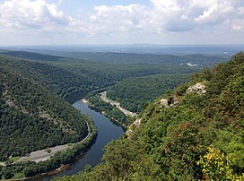
 View west from the Delaware Water Gap toward the Pocono Mountains in August 2013 | |
| Highest point | |
| Peak | Big Pine Hill |
| Elevation | 2,260–2,280 ft (690–690 m) |
| Coordinates | 41°13′44″N 75°22′24″W / 41.2290°N 75.3734°W |
| Naming | |
| Etymology | Lenape term for "stream between two mountains". |
| Geography | |
 Location of the Pocono Mountains in Pennsylvania
| |
The Pocono Mountains, commonly referred to as the Poconos (/ˈpoʊkənoʊz/), are a geographical, geological, and cultural region in Northeastern Pennsylvania. They overlook the Delaware River and Delaware Water Gap to the east, Lake Wallenpaupack to the north, Wyoming Valley and the Coal Region to the west, and the Lehigh Valley to the south. The name Pocono is derived from the Munsee word Pokawachne, which means "Creek Between Two Hills".[1]
Much of the Poconos region lies within the Greater New York–Newark, NY–NJ–CT–PA Combined Statistical Area. The wooded hills and valleys have long been a popular recreation area, accessible within a two-hour drive to millions of metropolitan area residents, with many Pocono communities having resort hotels with fishing, hunting, skiing, and other sports facilities.
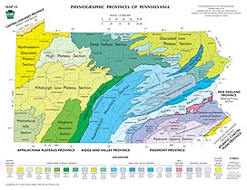
Although referred to usually as a mountain range, the area is actually a dissected plateau, a sub-section of the larger Allegheny Plateau, forming a 2,400-square-mile (6,200 km2) escarpment. The topological mountains are also a subrange of the Appalachian Mountains.
Population

The Pocono Mountains are a popular recreational destination for local and regional visitors. While the area has long been a popular tourist destination, many communities have seen a rise in population, especially communities within Monroe County and Pike County. The region has a population of about 340,300, which is growing at a rapid pace. The Poconos now serves as a commuter community for New York City and North Jersey.[2] The commute to workplaces often takes as much as two hours each way due to traffic.[3]
The region includes three major municipalities: Stroudsburg, East Stroudsburg, and Mount Pocono. The three towns and the surrounding townships are all located in Monroe County, Pennsylvania, where the population is 165,058, about half of which is in the Poconos.
Municipalities and communities

The Pocono Mountains of northeastern Pennsylvania are divided into six regions: the Mountain Region, the Lake Region, the Delaware River Region, the Upper Delaware River Region, Wyoming Valley, and the Lehigh River Gorge Region.[4][failed verification]
Mountain region
Located in Monroe, Luzerne, southern Lackawanna, and northern Carbon Counties:
- Albrightsville
- Barrett Township
- Bartonsville
- Bear Creek
- Blakeslee
- Canadensis
- Chestnuthill Township
- Coolbaugh Township
- Drifton
- Delaware Water Gap
- East Side
- East Stroudsburg
- Foster Township
- Freeland
- Gouldsboro
- Henryville
- Jackson Township
- Jim Thorpe
- Jonas, Pennsylvania
- Kidder Township
- Kunkletown
- Lake Harmony
- Lausanne Township
- Long Pond
- Marshalls Creek
- Middle Smithfield Township
- Mount Pocono
- Mountainhome
- Packer Township
- Paradise Township
- Penn Forest Township
- Penn Lake Park
- Pocono Lake
- Pocono Pines
- Pocono Summit
- Pocono Township
- Price Township
- Reeders
- Smithfield Township
- Saylorsburg
- Scotrun
- Stroudsburg
- Stroud Township
- Thornhurst Township
- Weatherly
- White Haven
- Swiftwater
- Tannersville
- Tobyhanna
Lake region

Located in Pike and Wayne Counties:
Delaware River region

Located in Monroe and Pike Counties:
Upper Delaware River region
Located in Pike and Wayne Counties:
Wyoming Valley
Located in Luzerne County:
Outlying areas
The boundary of the region can be at times unclear, and these Lehigh Valley, Carbon County, Schuylkill County, and Greater Hazleton (Luzerne County) communities fall on the periphery of the Poconos:
- Coaldale (Schuylkill County)
- Pen Argyl (Northampton County)
- Bangor (Northampton County)
- Walnutport (Northampton County)
- Macungie (Lehigh County)
- Slatington (Lehigh County)
- Drums (Luzerne County)
- Hazleton (Luzerne County)
- West Hazleton (Luzerne County)
- Aquashicola (Carbon County)
- Andreas (Carbon and Schuylkill Counties)
- Beaver Meadows (Carbon County)
- Ashfield (Carbon County)
- Bowmanstown (Carbon County)
- Forest Inn (Carbon County)
- Lansford (Carbon County)
- Lehighton (Carbon County)
- Nesquehoning (Carbon County)
- Palmerton (Carbon County)
- Parryville (Carbon County)
- Portland (Northampton County)
- Summit Hill (Carbon County)
- Tamaqua (Schuylkill County)
- Weissport (Carbon County)
Transportation
Roads

The Poconos are served by many state highways. The most used of these highways include Pennsylvania Route 115, Pennsylvania Route 715, Pennsylvania Route 903 (designated in some areas as the "Highway to Adventure" because of the numerous venues and resorts along the highway), Pennsylvania Route 33, Pennsylvania Route 940, and Pennsylvania Route 611. Pennsylvania Route 309, a major north–south route connecting Northeastern Pennsylvania with the Delaware Valley region, passes through the western end of the region.
There are two U.S. highways in the Pocono Mountains region. The more used is U.S. Route 209, which goes from Ulster, New York, to Millersburg, Pennsylvania near Harrisburg. The route's midpoint is in the region north of Stroudsburg. The other main U.S. Highway in the region is U.S. Route 6, which is a transcontinental highway that starts near Bishop, California, and runs for over 3,000 miles (4,800 km) to its eastern terminus in Provincetown, Massachusetts. It is designated a scenic route in Pennsylvania. U.S. Route 11, U.S. Route 22, and U.S. Route 46 are also not far from the region and serve it indirectly.
The main east–west interstate highway in the region is Interstate 80, off which branches Interstate 380, which connects the Poconos to Scranton. The other interstate highways in the region in Interstate 476, the Pennsylvania Turnpike's Northeast Extension, which has interchanges near Lehighton (Mahoning Valley), Albrightsville (Route 903), and White Haven (Pocono), and Interstate 81, which serves as an alternate route for the much busier Interstate 87 and Interstate 95, particularly for travelers from Toronto, Syracuse, Binghamton and Montreal to Philadelphia, Baltimore, and Washington, D.C. Other interstates that serve the region are Interstate 84, which begins in Scranton and goes east to New England, and Interstate 78, by way of Route 33 or Route 309.
Restoration of passenger rail service
NJ Transit is rebuilding trackage on the Lackawanna Cut-Off route from Scranton through the Poconos to Hoboken, New Jersey. There is no estimated target year when the Lackawanna Cut-Off Restoration Project will be completed to the Poconos. The service would consist of nine trains per day in each direction. In April 2022, the NJ Transit board approved a $32.5 million contract for improving a tunnel and restoring track to part of the line between Blairstown, New Jersey and Port Morris Junction, New Jersey,[5] a segment in which trackage had been removed in the 1980s.
Until 1970, the Erie Lackawanna Railway operated long-distance trains through the Poconos to Buffalo and Chicago to the west, and Hoboken to the east; the last Erie Lackawanna train to run this routes was Lake Cities, which operated from 1939 to 1970.
Air travel
There are two airports that are located just outside the region: Wilkes-Barre/Scranton International Airport and Lehigh Valley International Airport.
Geography

The Pocono Mountains is a defined area encompassing portions of Carbon, Monroe, Pike, and southern Wayne Counties in Pennsylvania.[6] In total, the Poconos encompasses over 2,500 square miles (6,500 km2).[citation needed] Some definitions also extend the Poconos to Lackawanna, Luzerne, eastern Schuylkill, and Susquehanna Counties. The Poconos are geologically part of the Allegheny Plateau, like the nearby Catskills. The Poconos' highest summit, Kistler Ledge in Monroe County, reaches over 2,215 feet (675 m), while its lowest elevation is 350 feet (110 m) in Pike County.[citation needed]
The Delaware River flows through the Pocono Mountains and gives the region its name, from a Native American term roughly translating to "stream between two mountains". The Lehigh and Lackawaxen Rivers also flow through the region, totaling about 170 miles (270 km) of waterways.[citation needed]
Climate
Glaciated Low Plateau region
According to the Trewartha climate classification system, the Glaciated Low Plateau region of the northern and eastern Poconos has a Temperate Continental climate (Dc) with warm summers (b), cold winters (o) and year-around precipitation (Dcbo). Dcbo climates are characterized by at least one month having an average mean temperature ≤ 32.0 °F (0.0 °C), four to seven months with an average mean temperature ≥ 50.0 °F (10.0 °C), all months with an average mean temperature < 72.0 °F (22.2 °C) and no significant precipitation difference between seasons. Although most summer days are comfortably humid on the Low Plateau, episodes of heat and high humidity can occur with heat index values > 93 °F (34 °C). Since 1981, the highest air temperature was 94.1 °F (34.5 °C) on 08/06/2001, and the highest daily average mean dew point was 70.8 °F (21.6 °C) on 08/01/2006. July is the peak month for thunderstorm activity which correlates with the average warmest month of the year. Since 1981, the wettest calendar day was 5.83 inches (148 mm) on 09/17/2004. During the winter months, the plant hardiness zone is 5b with an average annual extreme minimum air temperature of −13.1 °F (−25.1 °C).[7] Since 1981, the coldest air temperature was −27.9 °F (−33.3 °C) on 01/21/1994. Episodes of extreme cold and wind can occur with wind chill values less than −26 °F (−32 °C). The average snowiest month is January which correlates with the average coldest month of the year. Ice storms and large snowstorms depositing ≥ 12 inches (30 cm) of snow occur nearly every year, particularly during nor’easters from December through March.
| Climate data for Lake Wallenpaupack, Elevation 1,188 ft (362 m), 1981-2010 normals, extremes 1981-2018 | |||||||||||||
|---|---|---|---|---|---|---|---|---|---|---|---|---|---|
| Month | Jan | Feb | Mar | Apr | May | Jun | Jul | Aug | Sep | Oct | Nov | Dec | Year |
| Record high °F (°C) | 63.2 (17.3) |
72.2 (22.3) |
82.5 (28.1) |
87.8 (31.0) |
91.0 (32.8) |
90.7 (32.6) |
93.9 (34.4) |
94.1 (34.5) |
91.0 (32.8) |
83.1 (28.4) |
79.0 (26.1) |
67.5 (19.7) |
94.1 (34.5) |
| Mean daily maximum °F (°C) | 32.2 (0.1) |
35.3 (1.8) |
43.6 (6.4) |
56.0 (13.3) |
67.1 (19.5) |
75.1 (23.9) |
78.7 (25.9) |
78.1 (25.6) |
71.0 (21.7) |
59.8 (15.4) |
48.2 (9.0) |
36.4 (2.4) |
56.9 (13.8) |
| Daily mean °F (°C) | 22.5 (−5.3) |
25.0 (−3.9) |
32.9 (0.5) |
44.6 (7.0) |
55.2 (12.9) |
64.0 (17.8) |
67.9 (19.9) |
66.9 (19.4) |
59.4 (15.2) |
48.0 (8.9) |
38.6 (3.7) |
27.7 (−2.4) |
46.2 (7.9) |
| Mean daily minimum °F (°C) | 12.9 (−10.6) |
14.8 (−9.6) |
22.1 (−5.5) |
33.2 (0.7) |
43.4 (6.3) |
53.0 (11.7) |
57.1 (13.9) |
55.7 (13.2) |
47.7 (8.7) |
36.3 (2.4) |
29.0 (−1.7) |
18.9 (−7.3) |
35.4 (1.9) |
| Record low °F (°C) | −27.9 (−33.3) |
−17.3 (−27.4) |
−10.0 (−23.3) |
9.9 (−12.3) |
25.1 (−3.8) |
31.4 (−0.3) |
40.4 (4.7) |
35.9 (2.2) |
26.6 (−3.0) |
16.3 (−8.7) |
−1.9 (−18.8) |
−17.2 (−27.3) |
−27.9 (−33.3) |
| Average precipitation inches (mm) | 2.82 (72) |
2.55 (65) |
3.18 (81) |
3.62 (92) |
3.99 (101) |
4.46 (113) |
3.89 (99) |
3.77 (96) |
4.21 (107) |
4.18 (106) |
3.37 (86) |
3.32 (84) |
43.36 (1,101) |
| Average snowfall inches (cm) | 15.7 (40) |
11.2 (28) |
11.7 (30) |
2.8 (7.1) |
0.0 (0.0) |
0.0 (0.0) |
0.0 (0.0) |
0.0 (0.0) |
0.0 (0.0) |
0.1 (0.25) |
3.0 (7.6) |
9.4 (24) |
53.8 (137) |
| Average relative humidity (%) | 73.5 | 68.8 | 63.6 | 60.3 | 62.9 | 72.5 | 72.7 | 74.4 | 75.1 | 71.4 | 71.3 | 73.7 | 70.0 |
| Average dew point °F (°C) | 15.3 (−9.3) |
16.2 (−8.8) |
21.9 (−5.6) |
31.7 (−0.2) |
42.8 (6.0) |
55.0 (12.8) |
58.8 (14.9) |
58.5 (14.7) |
51.5 (10.8) |
39.2 (4.0) |
30.1 (−1.1) |
20.4 (−6.4) |
36.9 (2.7) |
| Source: PRISM[8] | |||||||||||||
Glaciated Pocono Plateau region
According to the Trewartha climate classification system, the Glaciated Pocono Plateau region of the central and western Poconos has a Temperate Continental climate (Dc) with warm summers (b), cold winters (o) and year-around precipitation (Dcbo). Dcbo climates are characterized by at least one month having an average mean temperature ≤ 32.0 °F (0.0 °C), four to seven months with an average mean temperature ≥ 50.0 °F (10.0 °C), all months with an average mean temperature < 72.0 °F (22.2 °C) and no significant precipitation difference between seasons. Although most summer days are comfortably humid on the Pocono Plateau, episodes of heat and high humidity can occur with heat index values > 93 °F (34 °C). Since 1981, the highest air temperature was 94.0 °F (34.4 °C) on 07/22/2011, and the highest daily average mean dew point was 70.7 °F (21.5 °C) on 08/01/2006. July is the peak month for thunderstorm activity which correlates with the average warmest month of the year. Since 1981, the wettest calendar day was 6.81 inches (173 mm) on 09/30/2010. During the winter months, the plant hardiness zone is 5b with an average annual extreme minimum air temperature of −10.1 °F (−23.4 °C).[7] Since 1981, the coldest air temperature was −21.6 °F (−29.8 °C) on 01/21/1994. Episodes of extreme cold and wind can occur with wind chill values < −22 °F (−30 °C). The average snowiest month is January which correlates with the average coldest month of the year. Ice storms and large snowstorms depositing ≥ 12 inches (30 cm) of snow occur nearly every year, particularly during nor’easters from December through March.
