Subantarctic - Biblioteka.sk

Upozornenie: Prezeranie týchto stránok je určené len pre návštevníkov nad 18 rokov!
Zásady ochrany osobných údajov.
Používaním tohto webu súhlasíte s uchovávaním cookies, ktoré slúžia na poskytovanie služieb, nastavenie reklám a analýzu návštevnosti. OK, súhlasím


Panta Rhei Doprava Zadarmo
...
...


A | B | C | D | E | F | G | H | CH | I | J | K | L | M | N | O | P | Q | R | S | T | U | V | W | X | Y | Z | 0 | 1 | 2 | 3 | 4 | 5 | 6 | 7 | 8 | 9
Subantarctic
 ...

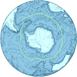
The Antarctic region and its boundary, the Antarctic Convergence

The subantarctic zone[1] is a region in the Southern Hemisphere, located immediately north of the Antarctic region. This translates roughly to a latitude of between 46° and 60° south of the Equator. The subantarctic region includes many islands in the southern parts of the Atlantic, Indian, and Pacific oceans, especially those situated north of the Antarctic Convergence. Subantarctic glaciers are, by definition, located on islands within the subantarctic region. All glaciers located on the continent of Antarctica are by definition considered to be Antarctic glaciers.

Geography

The subantarctic region comprises two geographic zones and three distinct fronts. The northernmost boundary of the subantarctic region is the rather ill-defined Subtropical Front (STF), also referred to as the Subtropical Convergence. To the south of the STF is a geographic zone, the Subantarctic Zone (SAZ). South of the SAZ is the Subantarctic Front (SAF). South of the SAF is another marine zone, called the Polar Frontal Zone (PFZ). The SAZ and the PFZ together form the subantarctic region. The southernmost boundary of the PFZ (and hence, the southern border of the subantarctic region) is the Antarctic Convergence, located approximately 200 kilometers south of the Antarctic Polar Front (APF).[2]

Influence of the Antarctic Circumpolar Current and thermohaline circulation

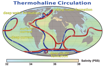
Diagram of the major ocean currents, showing the Antarctic Circumpolar Current (ACC). In addition to the global thermohaline circulation, the ACC strongly influences regional and global climate.
Global thermohaline circulation strongly influences regional and global climate. Blue paths represent deep-water currents, while red paths represent surface currents.

The subantarctic Front, found between 48°S and 58°S in the Indian and Pacific Ocean and between 42°S and 48°S in the Atlantic Ocean, defines the northern boundary of the Antarctic Circumpolar Current (or ACC).[2] The ACC is the most important ocean current in the Southern Ocean, and the only current that flows completely around the Earth. Flowing eastward through the southern portions of the Atlantic, Indian, and Pacific Oceans, the ACC links these three otherwise separate oceanic basins. Extending from the sea surface to depths of 2000–4000 meters, and with a width of as great as 2000 kilometers, the ACC transports more water than any other ocean current.[3] The ACC carries up to 150 Sverdrups (150 million cubic meters per second), equivalent to 150 times the volume of water flowing in all the world's rivers.[4] The ACC and the global thermohaline circulation strongly influence regional and global climate as well as underwater biodiversity.[5]

Another factor that contributes to the climate of the subantarctic region, though to a much lesser extent than the thermohaline circulation, is the formation of Antarctic Bottom Water (ABW) by halothermal dynamics. The halothermal circulation is that portion of the global ocean circulation that is driven by global density gradients created by surface heat and evaporation.

Definition of subantarctic: political versus scientific

Diagram showing different water masses in the Southern Ocean.

Several distinct water masses converge in the immediate vicinity of the APF or Antarctic Convergence (in particular the Subantarctic Surface Water (Subantarctic Mode Water or SAMW), Antarctic Surface Water, and the Antarctic Intermediate Water). This convergence creates a unique environment, noted for its very high marine productivity, especially for antarctic krill. Because of this, all lands and waters situated south of the Antarctic Convergence are considered to belong to the Antarctic from a climatological, biological and hydrological standpoint.[citation needed] However, the text of the Antarctic Treaty, article VI ("Area covered by Treaty") states: "The provisions of the present Treaty shall apply to the area south of 60° South latitude".[6] Therefore, Antarctica is defined from a political standpoint as all land and ice shelves south of 60°S latitude.

Subantarctic islands

Antarctica and surrounding islands in relation to the Antarctic Convergence and the 60th parallel south
Trees growing along the north shore of the Beagle Channel, 55°S.

At between about 46°50° south of the Equator, in the region often referred to as the Roaring Forties, are the Crozet Islands, the Prince Edward Islands, Wager Island, the Bounty Islands, the Snares Islands, the Kerguelen Islands, the Antipodes Islands, and the Auckland Islands. The geography of these islands is characterized by tundra, with some trees on the Snares Islands and the Auckland Islands. These islands are all located near the Antarctic Convergence (with the Kerguelen Islands south of the Convergence) and are properly considered to be subantarctic islands.

At between 51°56° south of the Equator, the Falkland Islands, Isla de los Estados, Ildefonso Islands, Diego Ramírez Islands, and other islands associated with Tierra del Fuego and Cape Horn, lie north of the Antarctic Convergence in the region often referred to as the Furious Fifties. Unlike other subantarctic islands, these islands have trees, temperate grasslands (mostly tussac grass), and even arable land. They also lack tundra and permanent snow and ice at their lowest elevations. Despite their more southerly location, it is debatable whether these islands should be considered as such because their climate and geography differs significantly from other subantarctic islands.

At between 52°57° south of the Equator, the Campbell Island Group, Heard Island and McDonald Islands, Bouvet Island, the South Georgia Group, Macquarie Island, and the South Sandwich Islands are also located in the Furious Fifties. The geography of these islands is characterized by tundra, permafrost, and volcanoes. These islands are situated close to or south of the Antarctic Convergence, but north of 60° S latitude (the continental limit according to the Antarctic Treaty).[6] Therefore, although some are located south of the Antarctic Convergence, they should still be considered as subantarctic islands by virtue of their location north of 60° S.[citation needed]

At between 60°69° south of the Equator, in the region often referred to as the Shrieking Sixties, the South Orkney Islands, South Shetland Islands, Balleny Islands, Scott Island, and Peter I Island are all properly considered to be Antarctic islands for the following three reasons:

  1. they are all located south of the Antarctic Convergence
  2. they are all located within the Southern (or Antarctic) Ocean
  3. they are all located south of the 60th parallel south

In light of the above considerations, the following should be considered to be subantarctic islands:

Name Coordinates[7][8] Ocean[7] Administered by
Antipodes Islands 49°40′S 178°46′E / 49.667°S 178.767°E / -49.667; 178.767 (Antipodes Islands) Pacific Ocean New Zealand
Auckland Islands 50°42′S 166°05′E / 50.700°S 166.083°E / -50.700; 166.083 (Auckland Islands) Pacific Ocean New Zealand
Bounty Islands 47°45′S 179°03′E / 47.750°S 179.050°E / -47.750; 179.050 (Bounty Islands) Pacific Ocean New Zealand
Bouvet Island (Bouvetøya) 54°26′S 03°24′E / 54.433°S 3.400°E / -54.433; 3.400 (Bouvet Island) Atlantic Ocean Norway
Campbell Island Group 52°32′S 169°08′E / 52.533°S 169.133°E / -52.533; 169.133 Pacific Ocean New Zealand
Crozet Islands (French: Îles Crozet or officially Archipel Crozet) 46°25′S 51°59′E / 46.417°S 51.983°E / -46.417; 51.983 (Crozet Islands) Indian Ocean France
Heard Island and McDonald Islands (HIMI) 53°04′S 73°00′E / 53.067°S 73.000°E / -53.067; 73.000 (HIMI) Indian Ocean Australia
Kerguelen Islands 49°15′S 69°35′E / 49.250°S 69.583°E / -49.250; 69.583 (Kerguelen Islands) Indian Ocean France
Macquarie Island 54°38′S 158°52′E / 54.633°S 158.867°E / -54.633; 158.867 (Macquarie Island) Pacific Ocean Australia
Prince Edward Islands 46°46′S 37°51′E / 46.767°S 37.850°E / -46.767; 37.850 (Prince Edward Islands) Indian Ocean South Africa
South Georgia Group 54°30′S 37°00′W / 54.500°S 37.000°W / -54.500; -37.000 (South Georgia Group) Atlantic Ocean United Kingdom
South Sandwich Islands 57°30′S 27°00′W / 57.500°S 27.000°W / -57.500; -27.000 (South Sandwich Islands) Atlantic Ocean United Kingdom
Snares Islands 48°01′S 166°32′E / 48.017°S 166.533°E / -48.017; 166.533 (The Snares) Pacific Ocean New Zealand

Subantarctic glaciers

This is a list of glaciers in the subantarctic. This list includes one snow field (Murray Snowfield). Snow fields are not glaciers in the strict sense of the word, but they are commonly found at the accumulation zone or head of a glacier.[9] For the purposes of this list, Antarctica is defined as any latitude further south than 60° (the continental limit according to the Antarctic Treaty).[6]

Satellite image of the southern tip of Heard Island. Cape Arkona is seen on the left side of the image, with Lied Glacier just above and Gotley Glacier just below. Big Ben Volcano and Mawson Peak are seen at the lower right side of the image.
Satellite image of central South Georgia: Harker Glacier, Cumberland Bay, Thatcher Peninsula, Allardyce Range, Mount Paget.
Neumayer Glacier, Cumberland West Bay, South Georgia, circa 1882–1883.
Nordenskjold Glacier, Cumberland Bay, South Georgia.
Zdroj:https://en.wikipedia.org?pojem=Subantarctic
Text je dostupný za podmienok Creative Commons Attribution/Share-Alike License 3.0 Unported; prípadne za ďalších podmienok. Podrobnejšie informácie nájdete na stránke Podmienky použitia.


Text je dostupný za podmienok Creative Commons Attribution/Share-Alike License 3.0 Unported; prípadne za ďalších podmienok.
Podrobnejšie informácie nájdete na stránke Podmienky použitia.

Your browser doesn’t support the object tag.

www.astronomia.sk | www.biologia.sk | www.botanika.sk | www.dejiny.sk | www.economy.sk | www.elektrotechnika.sk | www.estetika.sk | www.farmakologia.sk | www.filozofia.sk | Fyzika | www.futurologia.sk | www.genetika.sk | www.chemia.sk | www.lingvistika.sk | www.politologia.sk | www.psychologia.sk | www.sexuologia.sk | www.sociologia.sk | www.veda.sk I www.zoologia.sk


Name of Glacier Coordinates[7][8] Length or (Width)[7] Location
Abbotsmith Glacier 53°6′S 73°24′E / 53.100°S 73.400°E / -53.100; 73.400 4.8 km Heard Island
Allison Glacier 53°04′S 73°24′E / 53.067°S 73.400°E / -53.067; 73.400 Heard Island
Austin Glacier 54°4′S 37°12′W / 54.067°S 37.200°W / -54.067; -37.200 South Georgia Group
Bary Glacier 54°26′S 36°47′W / 54.433°S 36.783°W / -54.433; -36.783 South Georgia Group
Baudissin Glacier 53°2′S 73°26′E / 53.033°S 73.433°E / -53.033; 73.433 (2.8 km) Heard Island
Bertrab Glacier 54°37′S 35°57′W / 54.617°S 35.950°W / -54.617; -35.950 "small" South Georgia Group
Bogen Glacier 54°48′S 35°56′W / 54.800°S 35.933°W / -54.800; -35.933 "small" South Georgia Group
Briggs Glacier 54°1′S 37°8′W / 54.017°S 37.133°W / -54.017; -37.133 South Georgia Group
Brøgger Glacier 54°32′S 36°26′W / 54.533°S 36.433°W / -54.533; -36.433 13 km South Georgia Group
Brown Glacier 53°4′S 73°39′E / 53.067°S 73.650°E / -53.067; 73.650 Heard Island
Brunonia Glacier 54°3′S 37°29′W / 54.050°S 37.483°W / -54.050; -37.483 South Georgia Group
Buxton Glacier 54°26′S 36°12′W / 54.433°S 36.200°W / -54.433; -36.200 South Georgia Group
Challenger Glacier 53°2′S 73°28′E / 53.033°S 73.467°E / -53.033; 73.467 Heard Island
Christensen Glacier 54°2′S 36°52′W / 54.033°S 36.867°W / -54.033; -36.867 South Georgia Group
Christensen Glacier 54°28′S 3°24′E / 54.467°S 3.400°E / -54.467; 3.400 Bouvet Island
Christophersen Glacier 54°25′S 36°47′W / 54.417°S 36.783°W / -54.417; -36.783 South Georgia Group
Clayton Glacier 54°4′S 37°26′W / 54.067°S 37.433°W / -54.067; -37.433 South Georgia Group
Compton Glacier 53°3′S 73°37′E / 53.050°S 73.617°E / -53.050; 73.617 Heard Island
Cook Glacier 54°27′S 36°11′W / 54.450°S 36.183°W / -54.450; -36.183 South Georgia Group
Crean Glacier 54°8′S 37°1′W / 54.133°S 37.017°W / -54.133; -37.017 6 km South Georgia Group
Deacock Glacier 53°11′S 73°31′E / 53.183°S 73.517°E / -53.183; 73.517 Heard Island
Dead End Glacier 54°47′S 35°56′W / 54.783°S 35.933°W / -54.783; -35.933 South Georgia Group
Downes Glacier 53°2′S 73°31′E / 53.033°S 73.517°E / -53.033; 73.517 Heard Island
Ealey Glacier 53°2′S 73°35′E / 53.033°S 73.583°E / -53.033; 73.583 Heard Island
Eclipse Glacier 54°23′S 36°5′W / 54.383°S 36.083°W / -54.383; -36.083 South Georgia Group
Esmark Glacier 54°13′S 37°13′W / 54.217°S 37.217°W / -54.217; -37.217 South Georgia Group
Fiftyone Glacier 53°11′S 73°34′E / 53.183°S 73.567°E / -53.183; 73.567 Heard Island
Fortuna Glacier 54°6′S 36°51′W / 54.100°S 36.850°W / -54.100; -36.850 South Georgia Group
Geikie Glacier 54°17′S 36°41′W / 54.283°S 36.683°W / -54.283; -36.683 South Georgia Group
Gotley Glacier 53°10′S 73°27′E / 53.167°S 73.450°E / -53.167; 73.450 13.2 km Heard Island
Graae Glacier 54°48′S 36°1′W / 54.800°S 36.017°W / -54.800; -36.017 3.2 km South Georgia Group
Grace Glacier 54°4′S 37°23′W / 54.067°S 37.383°W / -54.067; -37.383 South Georgia Group
Hamberg Glacier 54°21′S 36°31′W / 54.350°S 36.517°W / -54.350; -36.517 South Georgia Group
Harker Glacier 54°22′S 36°32′W / 54.367°S 36.533°W / -54.367; -36.533 South Georgia Group
Harmer Glacier 54°46′S 36°15′W / 54.767°S 36.250°W / -54.767; -36.250 South Georgia Group
Heaney Glacier 54°25′S 36°12′W / 54.417°S 36.200°W / -54.417; -36.200 South Georgia Group
Helland Glacier 54°29′S 36°37′W / 54.483°S 36.617°W / -54.483; -36.617 South Georgia Group
Henningsen Glacier 54°27′S 36°42′W / 54.450°S 36.700°W / -54.450; -36.700 South Georgia Group
Herz Glacier 54°41′S 35°58′W / 54.683°S 35.967°W / -54.683; -35.967 South Georgia Group
Hindle Glacier 54°34′S 36°5′W / 54.567°S 36.083°W / -54.567; -36.083 10 km South Georgia Group
Hodges Glacier 54°16′S 36°32′W / 54.267°S 36.533°W / -54.267; -36.533 South Georgia Group
Horntvedt Glacier 54°25′S 3°21′E / 54.417°S 3.350°E / -54.417; 3.350 Bouvet Island
Jacka Glacier 53°00′S 73°20′E / 53.000°S 73.333°E / -53.000; 73.333 1.3 km Heard Island
Jenkins Glacier 54°46′S 36°7′W / 54.767°S 36.117°W / -54.767; -36.117 South Georgia Group
Jewell Glacier 54°16′S 37°8′W / 54.267°S 37.133°W / -54.267; -37.133 South Georgia Group
Keilhau Glacier 54°16′S 37°4′W / 54.267°S 37.067°W / -54.267; -37.067 8 km South Georgia Group
Kjerulf Glacier 54°21′S 36°51′W / 54.350°S 36.850°W / -54.350; -36.850 South Georgia Group
König Glacier 54°1′S 36°48′W / 54.017°S 36.800°W / -54.017; -36.800 South Georgia Group
Lancing Glacier 54°2′S 36°56′W / 54.033°S 36.933°W / -54.033; -36.933 South Georgia Group
Lewald Glacier 54°45′S 35°52′W / 54.750°S 35.867°W / -54.750; -35.867 South Georgia Group
Lied Glacier 53°9′S 73°26′E / 53.150°S 73.433°E / -53.150; 73.433 Heard Island
Lucas Glacier 54°4′S 37°18′W / 54.067°S 37.300°W / -54.067; -37.300 South Georgia Group
Lyell Glacier 54°17′S 36°37′W / 54.283°S 36.617°W / -54.283; -36.617 South Georgia Group
Mary Powell Glacier Heard Island
Morris Glacier 54°5′S 37°14′W / 54.083°S 37.233°W / -54.083; -37.233 South Georgia Group
Murray Snowfield 54°9′S 37°9′W / 54.150°S 37.150°W / -54.150; -37.150 South Georgia Group
Nachtigal Glacier 54°29′S 36°9′W / 54.483°S 36.150°W / -54.483; -36.150 South Georgia Group
Neumayer Glacier 54°15′S 36°41′W / 54.250°S 36.683°W / -54.250; -36.683 13 km South Georgia Group
Nordenskjöld Glacier 54°22′S 36°22′W / 54.367°S 36.367°W / -54.367; -36.367 "large" South Georgia Group
Novosilski Glacier