

A | B | C | D | E | F | G | H | CH | I | J | K | L | M | N | O | P | Q | R | S | T | U | V | W | X | Y | Z | 0 | 1 | 2 | 3 | 4 | 5 | 6 | 7 | 8 | 9
Rhode Island | |
|---|---|
| State of Rhode Island | |
| Nickname(s): The Ocean State Little Rhody[1] | |
| Motto: Hope | |
| Anthem: "Rhode Island's It for Me" | |
_(extra_close).svg) Map of the United States with Rhode Island highlighted | |
| Country | United States |
| Before statehood | Colony of Rhode Island and Providence Plantations |
| Admitted to the Union | May 29, 1790 (13th) |
| Capital (and largest city) | Providence |
| Largest county or equivalent | Providence |
| Largest metro and urban areas | Greater Boston (combined) Providence (metro and urban) |
| Government | |
| • Governor | Dan McKee (D) |
| • Lieutenant Governor | Sabina Matos (D) |
| Legislature | Rhode Island General Assembly |
| • Upper house | Senate |
| • Lower house | House of Representatives |
| Judiciary | Rhode Island Supreme Court |
| U.S. senators | Jack Reed (D) Sheldon Whitehouse (D) |
| U.S. House delegation | 1: Gabe Amo (D) 2: Seth Magaziner (D) (list) |
| Area | |
| • Total | 1,545 sq mi (4,001 km2) |
| • Land | 1,034 sq mi (2,678 km2) |
| • Water | 511 sq mi (1,324 km2) |
| • Rank | 50th |
| Dimensions | |
| • Length | 48 mi (77 km) |
| • Width | 37 mi (60 km) |
| Elevation | 200 ft (60 m) |
| Highest elevation | 812 ft (247 m) |
| Lowest elevation (Atlantic Ocean[3]) | 0 ft (0 m) |
| Population (2020 Census Results) | |
| • Total | 1,098,163[4] |
| • Rank | 45th |
| • Density | 1,006/sq mi (388/km2) |
| • Rank | 2nd |
| • Median household income | $63,870[5] |
| • Income rank | 15th |
| Demonym | Rhode Islander |
| Language | |
| • Official language | De jure: None De facto: English |
| Time zone | UTC–05:00 (Eastern) |
| • Summer (DST) | UTC–04:00 (EDT) |
| USPS abbreviation | RI |
| ISO 3166 code | US-RI |
| Traditional abbreviation | R.I. |
| Latitude | 41° 09′ N to 42° 01′ N |
| Longitude | 71° 07′ W to 71° 53′ W |
| Website | ri |

.svg)
Rhode Island (/ˌroʊd-/ ROHD)[6][7] is a state in the New England region of the Northeastern United States. It borders Connecticut to its west; Massachusetts to its north and east; and the Atlantic Ocean to its south via Rhode Island Sound and Block Island Sound; and shares a small maritime border with New York, east of Long Island.[8] Rhode Island is the smallest U.S. state by area and the seventh-least populous, with slightly fewer than 1.1 million residents as of 2020;[9] but it has grown at every decennial count since 1790 and is the second-most densely populated state, after New Jersey. The state takes its name from the eponymous island, though nearly all its land area is on the mainland. Providence is its capital and most populous city.
Native Americans lived around Narragansett Bay for thousands of years before English settlers began arriving in the early 17th century.[10] Rhode Island was unique among the Thirteen British Colonies in having been founded by a refugee, Roger Williams, who fled religious persecution in the Massachusetts Bay Colony to establish a haven for religious liberty. He founded Providence in 1636 on land purchased from local tribes, creating the first settlement in North America with an explicitly secular government.[10] The Colony of Rhode Island and Providence Plantations subsequently became a destination for religious and political dissenters and social outcasts, earning it the moniker "Rogue's Island".[11]
Rhode Island was the first colony to call for a Continental Congress, in 1774, and the first to renounce its allegiance to the British Crown, on May 4, 1776.[12] After the American Revolution, during which it was heavily occupied and contested, Rhode Island became the fourth state to ratify the Articles of Confederation, on February 9, 1778.[13] Because its citizens favored a weaker central government, it boycotted the 1787 convention that had drafted the United States Constitution,[14] which it initially refused to ratify;[15] it finally ratified it on May 29, 1790, the last of the original 13 states to do so.[16][17]
The state was officially named the State of Rhode Island and Providence Plantations since the colonial era but came to be commonly known as "Rhode Island". In November 2020, the state's voters approved an amendment to the state constitution formally dropping "and Providence Plantations" from its full name.[18] Its official nickname is the "Ocean State", a reference to its 400 mi (640 km) of coastline and the large bays and inlets that make up about 14% of its area.[19]
Name
Origin of the name
Despite its name, most of Rhode Island is on the U.S. mainland. Its official name was State of Rhode Island and Providence Plantations from its beginning in 1636 until 2020, and it is referred to in that manner in the United States Constitution.[20] This name was derived from the merger of Colonial settlements around Narragansett Bay, and outside the jurisdiction of Plymouth colony. The settlements of Rhode Island (Newport and Portsmouth) were on Rhode Island, also known as Aquidneck Island.[b][21] Providence Plantations referred to settlements on the mainland of Providence and Warwick.[22]
It is unclear how the island came to be named Rhode Island, but two historical events may have been influential:
- Explorer Giovanni da Verrazzano noted the presence of an island near the mouth of Narragansett Bay in 1524 which he likened to the island of Rhodes off the coast of Greece.[23] Subsequent European explorers were unable to precisely identify the island Verrazzano described, but the colonists who settled the area assumed that it was this island.[c]
- Adriaen Block passed by the island during his expeditions in the 1610s, and described it in a 1625 account of his travels as "an island of reddish appearance", which was "een rodlich Eylande" in 17th-century Dutch, meaning a red or reddish island, supposedly evolving into the designation Rhode Island.[24][25] Historians have theorized that this "reddish appearance" resulted from either red autumn foliage or red clay on portions of the shore.[26]
The earliest documented use of the name "Rhode Island" for Aquidneck was in 1637 by Roger Williams. The name was officially applied to the island in 1644 with these words: "Aquethneck shall be henceforth called the Isle of Rodes or Rhode-Island." The name "Isle of Rodes" is used in a legal document as late as 1646.[27][28] Dutch maps as early as 1659 call the island "Red Island" (Roodt Eylandt).[29]
Changes to the name
The first English settlement in Rhode Island was the town of Providence, which the Narragansett granted to Roger Williams in 1636.[citation needed] At that time, Williams obtained no permission from the English crown, as he believed the English had no legitimate claim on Narragansett and Wampanoag territory.[30][verification needed] Williams traveled to London in 1643, during the English Civil War, to obtain legal recognition of the new settlements. A Patent was granted to "the incorporation of Providence Plantations in Narragansett Bay in New England" by the Parliamentary committee on Foreign Plantations.[31] After the English Civil war, a Royal Charter was granted in 1663, giving the colony an official name of the "Governor and Company of the English Colony of Rhode Island and Providence Plantations, in New England, in America."[32] Following the American Revolution, in 1790 the new state incorporated as the "State of Rhode Island and Providence Plantations". However, as matter of convenience, the state came to be commonly known as simply "Rhode Island".
The word plantation in the state's name became a contested issue during the 20th century and the increased awareness of slavery and its role in early Rhode Island history. The General Assembly voted in 2009 to hold a referendum in November 2010 on removing "and Providence Plantations" from the official name. Advocates for excising plantation argued that the word symbolized a legacy of disenfranchisement for many Rhode Islanders, as well as the proliferation of slavery in the colonies and in the post-colonial United States. Advocates for retaining the name argued that plantation was simply an archaic synonym for colony and bore no relation to slavery. The people voted overwhelmingly (78% to 22%) to retain the entire original name.[33]
In June 2020, State Senator Harold Metts introduced a resolution for another ballot referendum on the subject, saying, "Whatever the meaning of the term 'plantations' in the context of Rhode Island's history, it carries a horrific connotation when considering the tragic and racist history of our nation."[34] Governor Gina Raimondo issued an executive order to remove the phrase from a range of official documents and state websites.[35] In July, amidst the George Floyd protests and nationwide calls to address "systemic racism", the resolution referring the question to the voters was passed by both houses of the Rhode Island General Assembly: 69–1 in the House of Representatives,[36] and 35–0 in the Senate.[37] The change was then approved by voters 52.8% to 47.2% as part of the 2020 United States elections, taking effect in November 2020 upon certification of the results.[18][38]
History
Colonial era: 1636–1770

In 1636, Roger Williams was banished from the Massachusetts Bay Colony for his religious views, and he settled at the top of Narragansett Bay on land sold or given to him by Narragansett sachem Canonicus. He named the site Providence, "having a sense of God's merciful providence unto me in my distress",[39] and it became a place of religious freedom where all were welcome.

In 1638 (after conferring with Williams), Anne Hutchinson, William Coddington, John Clarke, Philip Sherman, and other religious dissenters were allowed to settle on Aquidneck Island (also known as Rhode Island), by the Narragansett Sachems Canonicus and Miantonomi. They were given a few items in reciprocity for their generosity. However, as Roger Williams made clear in a letter to John Winthrop in June 1638: "Sir, concerning the islands Prudence and…Aquedenick…neither of them were sold properly, for a thousand fathom would not have bought either, by strangers. The truth is, not a penny was demanded for either, and what was paid was only gratuity, though I chose, for better assurance and form, to call it sale."[40] This settlement was first called Pocasset and then changed in 1639 to Portsmouth. The town was governed by the Portsmouth Compact. The island's southern part became the separate settlement of Newport after disagreements among the founders.
Samuel Gorton purchased lands at Shawomet in 1642 from the Narragansetts, precipitating a dispute with the Massachusetts Bay Colony. In 1644, Providence, Portsmouth, and Newport united for their common independence as the Colony of Rhode Island and Providence Plantations, governed by an elected council and "president". Gorton received a separate charter for his settlement in 1648 which he named Warwick after his patron.[41]
Metacomet was the Wampanoag tribe's war leader, whom the colonists called King Philip. They invaded and burned down several of the towns in the area during King Philip's War (1675–1676), including Providence which was attacked twice.[39] A force of Massachusetts, Connecticut, and Plymouth militia under General Josiah Winslow invaded and destroyed the fortified Narragansett Indian village in the Great Swamp in South Kingstown, Rhode Island on December 19, 1675.[42] In one of the final actions of the war, an Indian associated with Benjamin Church killed King Philip in Bristol, Rhode Island.[43]

The colony was amalgamated into the Dominion of New England in 1686, as King James II attempted to enforce royal authority over the autonomous colonies in British North America, but the colony regained its independence under the Royal Charter after the Glorious Revolution of 1688. Slaves were introduced in Rhode Island at this time, although there is no record of any law legalizing slave-holding. The colony later prospered under the slave trade, distilling rum to sell in Africa as part of a profitable triangular trade in slaves and sugar with the Caribbean.[45] Rhode Island's legislative body passed an act in 1652 abolishing the holding of slaves (the first British colony to do so), but this edict was never enforced and Rhode Island continued to be heavily involved in the slave trade during the post-revolution era.[46] In 1774, the slave population of Rhode Island was 6.3% of the total (nearly twice the ratio of other New England colonies).[47][48]
Brown University was founded in 1764 as the College in the British Colony of Rhode Island and Providence Plantations. It was one of nine Colonial colleges granted charters before the American Revolution and was the first college in America to accept students regardless of religious affiliation.[49]
Revolutionary to Civil War period: 1770–1860
_(cropped).jpg)
Rhode Island's tradition of independence and dissent gave it a prominent role in the American Revolution. At approximately 2 a.m. on June 10, 1772, a band of Providence residents attacked the grounded revenue schooner HMS Gaspée, burning it to the waterline for enforcing unpopular trade regulations within Narragansett Bay.[50] Rhode Island was the first of the thirteen colonies to renounce its allegiance to the British Crown on May 4, 1776.[51] It was also the last of the thirteen colonies to ratify the United States Constitution on May 29, 1790, and only under threat of heavy trade tariffs from the other former colonies and after assurances were made that a Bill of Rights would become part of the Constitution.[52]

During the Revolution, the British occupied Newport in December 1776. A combined Franco-American force fought to drive them off Aquidneck Island. Portsmouth was the site of the first African-American military unit, the 1st Rhode Island Regiment, to fight for the U.S. in the unsuccessful Battle of Rhode Island of August 29, 1778.[53] A month earlier, the appearance of a French fleet off Newport caused the British to scuttle some of their own ships in an attempt to block the harbor. The British abandoned Newport in October 1779, concentrating their forces in New York City. An expedition of 5,500 French troops under Count Rochambeau arrived in Newport by sea on July 10, 1780.[54] The celebrated march to Yorktown, Virginia, in 1781 ended with the defeat of the British at the Siege of Yorktown and the Battle of the Chesapeake.
Rhode Island was also heavily involved in the Industrial Revolution, which began in America in 1787 when Thomas Somers reproduced textile machine plans which he imported from England. He helped to produce the Beverly Cotton Manufactory, in which Moses Brown of Providence took an interest. Moses Brown teamed up with Samuel Slater and helped to create the second cotton mill in America, a water-powered textile mill. The Industrial Revolution moved large numbers of workers into the cities. With the 1663 colonial charter still in effect, voting was restricted to landowners holding at least $134 in property. At the time of the revolution, 80% of White men in Rhode Island could vote; by 1840, only 40% were still eligible.[55] The charter apportioned legislative seats equally among the state's towns, over-representing rural areas and under-representing the growing industrial centers. Additionally, the charter disallowed landless citizens from filing civil suits without endorsement from a landowner.[56] Bills were periodically introduced in the legislature to expand suffrage, but they were invariably defeated.
In 1841, activists led by Thomas W. Dorr organized an extralegal convention to draft a state constitution,[57] arguing the charter government violated the Guarantee Clause in Article Four, Section Four of the United States Constitution. In 1842, the charter government and Dorr's supporters held separate elections, and two rival governments claimed sovereignty over the state. Dorr's supporters led an armed rebellion against the charter government, and Dorr was arrested and imprisoned for treason against the state.[58]
In response, the legislature drafted a state constitution which replaced property requirements for American-born citizens with a $1 poll tax, equivalent to $32 in 2023. In a heavily boycotted election in November 1842, voters approved the constitution.[citation needed] Voters also declined to limit the change to "white" men, thus re-enfranchising Black men—Black men meeting the property requirements had been able to vote in Rhode Island until 1822. The constitution also ended slavery. Immigrants remained subject to the property requirement, effectively disenfranchising many Irish-Americans and maintaining urban under-representation.[59][60] In 1849, in Luther v. Borden, the US Supreme Court declined to rule on the constitutional question raised in Dorr's rebellion, holding that it was a political question outside its jurisdiction.
In the early 19th century, Rhode Island was subject to a tuberculosis outbreak which led to public hysteria about vampirism.[61][62]
Civil War

During the American Civil War, Rhode Island was the first Union state to send troops in response to President Lincoln's request for help from the states. Rhode Island furnished 25,236 fighting men, of whom 1,685 died.[citation needed] On the home front, Rhode Island and the other northern states used their industrial capacity to supply the Union Army with the materials it needed to win the war. The United States Naval Academy moved to Rhode Island temporarily during the war.
In 1866, Rhode Island abolished racial segregation in the public schools throughout the state.[63]
Gilded Age

The 50 years following the Civil War were a time of prosperity and affluence that author William G. McLoughlin calls "Rhode Island's halcyon era". Rhode Island was a center of the Gilded Age and provided a home or summer home to many of the country's most prominent industrialists. This was a time of growth in textile mills and manufacturing and brought an influx of immigrants to fill those jobs, bringing population growth and urbanization. In Newport, New York's wealthiest industrialists created a summer haven to socialize and build grand mansions. Thousands of French-Canadian, Italian, Irish, and Portuguese immigrants arrived to fill jobs in the textile and manufacturing mills in Providence, Pawtucket, Central Falls, and Woonsocket.[64]
World War I
During World War I, Rhode Island furnished 28,817 soldiers, of whom 612 died. After the war, the state was hit hard by the Spanish Influenza.[65]
In the 1920s and 1930s, rural Rhode Island saw a surge in Ku Klux Klan membership, largely in reaction to large waves of immigrants moving to the state. The Klan is believed to be responsible for burning the Watchman Industrial School in Scituate, which was a school for African-American children.[66]
Growth in the modern era: 1929–present
Since the Great Depression, the Rhode Island Democratic Party has dominated local politics. Rhode Island has comprehensive health insurance for low-income children and a large social safety net. Many urban areas still have a high rate of children in poverty. Due to an influx of residents from Boston, increasing housing costs have resulted in more homelessness in Rhode Island.[67]

The 350th Anniversary of the founding of Rhode Island was celebrated with a free concert held on the tarmac of the Quonset State Airport on August 31, 1986. Performers included Chuck Berry, Tommy James, and headliner Bob Hope.
In 2003, a nightclub fire in West Warwick claimed 100 lives and resulted in nearly twice as many injured, catching national attention. The fire resulted in criminal sentences.[68]
In March 2010, areas of the state received record flooding due to rising rivers from heavy rain. The first period of rainy weather in mid-March caused localized flooding and, two weeks later, more rain caused more widespread flooding in many towns, especially south of Providence. Rain totals on March 29–30, 2010 exceeded 14 inches (35.5 cm) in many locales, resulting in the inundation of area rivers—especially the Pawtuxet River which runs through central Rhode Island. The overflow of the Pawtuxet River, nearly 11 feet (3 m) above flood stage, submerged a sewage treatment plant and closed a five-mile (8 km) stretch of Interstate 95. In addition, it flooded two shopping malls, numerous businesses, and many homes in the towns of Warwick, West Warwick, Cranston, and Westerly. Amtrak service was also suspended between New York and Boston during this period. Following the flood, Rhode Island was in a state of emergency for two days. The Federal Emergency Management Agency (FEMA) was called in to help flood victims.
Geography
.png)
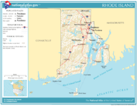
Rhode Island covers an area of 1,214 square miles (3,144 km2)[2] within the New England region of the Northeastern United States and is bordered on the north and east by Massachusetts, on the west by Connecticut, and on the south by Rhode Island Sound and the Atlantic Ocean.[19] It shares a narrow maritime border with New York State between Block Island and Long Island. The state's mean elevation is 200 feet (61 m). It is only 37 miles (60 km) wide and 48 miles (77 km) long, yet the state has a tidal shoreline on Narragansett Bay and the Atlantic Ocean of 384 miles (618 km).[69]
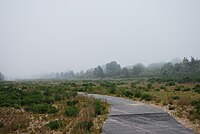
Rhode Island is nicknamed the Ocean State and has a number of oceanfront beaches. It is mostly flat with no real mountains, and the state's highest natural point is Jerimoth Hill, 812 feet (247 m) above sea level.[70] The state has two distinct natural regions. Eastern Rhode Island contains the lowlands of the Narragansett Bay, while Western Rhode Island forms part of the New England upland. Rhode Island's forests are part of the Northeastern coastal forests ecoregion.[71]
Narragansett Bay is a major feature of the state's topography. There are more than 30 islands within the bay; the largest is Aquidneck Island, which holds the municipalities of Newport, Middletown, and Portsmouth. The second-largest island is Conanicut, and the third is Prudence. Block Island lies about 12 miles (19 km) off the southern coast of the mainland and separates Block Island Sound and the Atlantic Ocean proper.[72][73]
A rare type of rock called Cumberlandite is found only in Rhode Island (specifically, in the town of Cumberland) and is the state rock. There were initially two known deposits of the mineral, but it is an ore of iron, and one of the deposits was extensively mined for its ferrous content.[74][d]
- Geography of Rhode Island
-
 Map of Rhode Island, showing major cities and roads
 -
 Rocky shoreline in Newport
 -
-


_(8158417032).jpg)
Climate

Most of Rhode Island has a humid continental climate, with warm summers and cold winters. The state's southern coastal portions are the broad transition zone into subtropical climates, with hot summers and cool winters with a mix of rain and snow. Block Island has an oceanic climate. The highest temperature recorded in Rhode Island was 104 °F (40 °C), recorded on August 2, 1975, in Providence.[76] The lowest recorded temperature in Rhode Island was −23 °F (−31 °C) on February 5, 1996, in Greene.[77] Monthly average temperatures range from a high of 83 °F (28 °C) to a low of 20 °F (−7 °C).[78]
Rhode Island is vulnerable to tropical storms and hurricanes due to its location in New England, catching the brunt of many storms that blow up the eastern seaboard. Hurricanes that have done significant damage in the state include the 1938 New England hurricane, Hurricane Carol (1954), Hurricane Donna (1960), and Hurricane Bob (1991).
Cities and towns
Rhode Island is divided into five counties but it has no county governments. The entire state is divided into 39 municipalities, which handle all local government affairs.
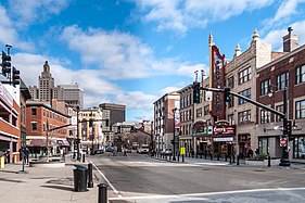
There are 8 cities and 31 towns in Rhode Island. Major population centers today result from historical factors; development took place predominantly along the Blackstone, Seekonk, and Providence Rivers with the advent of the water-powered mill. Providence is the base of a large metropolitan area.
The state's 19 largest municipalities ranked by population are:[79]
- Providence (190,934)
- Cranston (82,934)
- Warwick (82,823)
- Pawtucket (75,604)
- East Providence (47,139)
- Woonsocket (43,240)
- Cumberland (36,405)
- Coventry (35,688)
- North Providence (34,114)
- South Kingstown (31,931)
- West Warwick (31,012)
- Johnston (29,568)
- North Kingstown (27,732)
- Newport (25,163)
- Westerly (23,359)
- Central Falls (22,583)
- Lincoln (22,529)
- Bristol (22,493)
- Smithfield (22,118)
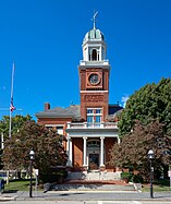
Some of Rhode Island's cities and towns are further partitioned into villages, in common with many other New England states. Notable villages include Kingston in the town of South Kingstown, which houses the University of Rhode Island; Wickford in the town of North Kingstown, the site of an annual international art festival; and Wakefield where the Town Hall is for the Town of South Kingstown.[80]
- Major cities of Rhode Island
-
 1. Providence
 -
 2. Cranston
 -
 3. Warwick
 -
 4. Pawtucket
 -

-
 6. Woonsocket
 -
 7. Coventry
 -
 8. Cumberland
 -

-
 10. South Kingstown
 -
 11. Johnston
 -
 12. West Warwick
 -
 13. North Kingstown
 -
 14. Newport
 -
 15. Westerly
.jpg)


.jpg)


Landmarks

The state capitol building is made of white Georgian marble. On top is the world's fourth largest self-supported marble dome.[81] It houses the Rhode Island Charter granted by King Charles II in 1663, the Brown University charter, and other state treasures.
The First Baptist Church of Providence is the oldest Baptist church in the Americas, founded by Roger Williams in 1638.
The first fully automated post office in the country is in Providence. There are many historic mansions in the seaside city of Newport, including The Breakers, Marble House, and Belcourt Castle. Also there is the Touro Synagogue, dedicated on December 2, 1763, considered by locals to be the first synagogue within the United States (see below for information on New York City's claim), and still serving. The synagogue showcases the religious freedoms established by Roger Williams, as well as impressive architecture in a mix of the classic colonial and Sephardic style. The Newport Casino is a National Historic Landmark building complex that houses the International Tennis Hall of Fame and features an active grass-court tennis club.

Scenic Route 1A (known locally as Ocean Road) is in Narragansett. "The Towers" is also in Narragansett featuring a large stone arch. It was once the entrance to a famous Narragansett casino that burned down in 1900. The Towers now serve as an event venue and host the local Chamber of Commerce, which operates a tourist information center.
The Newport Tower has been hypothesized to be of Viking origin, although most experts believe it was a Colonial-era windmill.[82]
Environment
Environmental legislation

On May 29, 2014, Governor Lincoln D. Chafee announced that Rhode Island was one of eight states to release a collaborative Action Plan to put 3.3 million zero-emission vehicles on its roads by 2025. The plan's purpose is to reduce greenhouse gas and smog-causing emissions. The plan promotes zero-emissions vehicles and investments in the infrastructure to support them.[84]
In 2014, Rhode Island received grants of $2,711,685 from the Environmental Protection Agency to clean up Brownfield sites in eight locations. The grants provided communities with funding to assess, clean up, and redevelop contaminated properties, boost local economies, and leverage jobs while protecting public health and the environment.[85]
In 2013, the "Lots of Hope" program was established in the City of Providence to focus on increasing the city's green space and local food production, improve urban neighborhoods, promote healthy lifestyles and improve environmental sustainability. Supported by a $100,000 grant, the program will partner with the City of Providence, the Southside Community Land Trust, and the Rhode Island Foundation to convert city-owned vacant lots into productive urban farms.[86]
In 2012, Rhode Island passed bill S2277/H7412, "An act relating to Health and Safety – Environmental Cleanup Objectives for Schools", informally known as the School Siting Bill. Sponsored by Senator Juan Pichardo and Representative Scott Slater, and signed into law by the governor, it made Rhode Island the first US State to prohibit school construction on Brownfield sites where toxic vapors can potentially affect indoor air quality. It also creates a public participation process whenever a city or town considers building a school on any other kind of contaminated site.[87]
Environmental monitoring
The Invasive Plant Atlas of New England monitors invasive weeds throughout New England.[88]
Demographics
| Census | Pop. | Note | %± |
|---|---|---|---|
| 1790 | 68,825 | — | |
| 1800 | 69,122 | 0.4% | |
| 1810 | 76,931 | 11.3% | |
| 1820 | 83,059 | 8.0% | |
| 1830 | 97,199 | 17.0% | |
| 1840 | 108,830 | 12.0% | |
| 1850 | 147,545 | 35.6% | |
| 1860 | 174,620 | 18.4% | |
| 1870 | 217,353 | 24.5% | |
| 1880 | 276,531 | 27.2% | |
| 1890 | 345,506 | 24.9% | |
| 1900 | 428,556 | 24.0% | |
| 1910 | 542,610 | 26.6% | |
| 1920 | 604,397 | 11.4% | |
| 1930 | 687,497 | 13.7% | |
| 1940 | 713,346 | 3.8% | |
| 1950 | 791,896 | 11.0% | |
| 1960 | 859,488 | 8.5% | |
| 1970 | 946,725 | 10.1% | |
| 1980 | 947,154 | 0.0% | |
| 1990 | 1,003,464 | 5.9% | |
| 2000 | 1,048,319 | 4.5% | |
| 2010 | 1,052,567 | 0.4% | |
| 2020 | 1,097,379 | 4.3% | |
| 2023 (est.) | 1,095,962 | −0.1% | |
| Source: 1910–2020[89] | |||


At the 2020 U.S. census, Rhode Island's population was 1,097,379. The center of population of Rhode Island is in Providence County, in the city of Cranston.[90] A corridor of population can be seen from the Providence area, stretching northwest following the Blackstone River to Woonsocket, where 19th-century mills drove industry and development.
According to HUD's 2022 Annual Homeless Assessment Report, there were an estimated 1,577 homeless people in Rhode Island.[91][92]
According to the 2020 census, 71.3% of the population was White (68.7% non-Hispanic white), 5.7% was Black or African American, 0.7% American Indian and Alaska Native, 3.6% Asian, 0.0% Native Hawaiian and other Pacific Islander, 9.4% from some other race, and 9.3% from two or more races. 16.6% of the total population was of Hispanic or Latino origin (they may be of any race).[93]