A | B | C | D | E | F | G | H | CH | I | J | K | L | M | N | O | P | Q | R | S | T | U | V | W | X | Y | Z | 0 | 1 | 2 | 3 | 4 | 5 | 6 | 7 | 8 | 9
Fairfax County | |
|---|---|
CIA headquarters in Langley | |
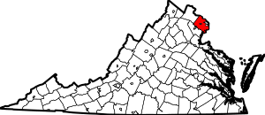
 Location within the U.S. state of Virginia | |
 Virginia's location within the U.S. | |
| Coordinates: 38°50′N 77°17′W / 38.83°N 77.28°W | |
| Country | |
| State | |
| Founded | June 19, 1742 |
| Named for | Thomas Fairfax, 6th Lord Fairfax of Cameron |
| Seat | Fairfax (independent city)1 |
| Largest town | Herndon |
| Area | |
| • Total | 406 sq mi (1,050 km2) |
| • Land | 391.02 sq mi (1,012.7 km2) |
| • Water | 15.47 sq mi (40.1 km2) 3.8% |
| Population (2020) | |
| • Total | 1,150,309 |
| • Density | 2,941.82/sq mi (1,135.84/km2) |
| Time zone | UTC−5 (Eastern) |
| • Summer (DST) | UTC−4 (EDT) |
| ZIP Codes | 20120, 20121, 20122, 20124, 20151, 20152, 20153, 20164, 20166, 20170, 20171, 20172, 20190, 20191, 20192, 20194, 20195, 20196, 22003, 22009, 22015, 22018, 22019, 22027, 22030, 22031, 22032, 22033, 22035, 22037, 22038, 22039, 22041, 22042, 22043, 22044, 22046, 22060, 22066, 22067, 22079, 22081, 22082, 22101, 22102, 22106, 22116, 22121, 22124, 22150, 22151, 22152, 22153, 22158, 22159, 22160, 22161, 22180, 22181, 22182, 22183, 22185, 22199, 22203, 22204, 22205, 22206, 22207, 22213, 22302, 22303, 22304, 22306, 22307, 22308, 22309, 22310, 22311, 22312, 22315 |
| Area code | 703, 571 |
| Congressional districts | 8th, 10th, 11th |
| Website | www |
| 1 Administrative and court offices are located in unincorporated areas in Fairfax County | |
Fairfax County, officially the County of Fairfax, is a county in the Commonwealth of Virginia. With a population of 1,150,309 as of the 2020 census,[1] it is the most populous county in Virginia, the most populous jurisdiction in the Washington metropolitan area, and the most populous location in the Washington–Baltimore combined statistical area. The county seat is Fairfax; however, because it is an independent city under Virginia law, the city of Fairfax is not part of the county.[2]
The county is part of the Northern Virginia region and forms part of the suburban ring of Washington, D.C., the nation's capital. The county is predominantly suburban with some urban and rural pockets. It borders Montgomery County, Maryland to its north, Falls Church, Alexandria, Arlington County, and Prince George's County, Maryland to its east, Charles County, Maryland to its southeast, Prince William County to its southwest, and Loudoun County to its northwest.
The county is home to the offices of the director of national intelligence in McLean and the headquarters of four U.S. intelligence agencies: the Central Intelligence Agency at the George Bush Center for Intelligence in Langley, the National Geospatial-Intelligence Agency in Springfield, the National Reconnaissance Office in Chantilly, and the National Counterterrorism Center in McLean.
In academia, the county is home to the flagship campus of George Mason University in Fairfax, CIA University in Chantilly, Sherman Kent School for Intelligence Analysis in Reston, and several Northern Virginia Community College campuses. In the private sector, ten of the Fortune 500 companies are headquartered in the county as of 2023.[3]
As of 2020, Fairfax County's median household income of $127,866 is the fifth-highest in the nation.
History


Prior to European settlement, present-day Fairfax County was initially inhabited by the Algonquian-speaking Doeg tribe.
17th century
In 1608, Caption John Smith documented the Doeg tribe's villages, which included Namassingakent and Nemaroughquand on the south bank of the Potomac River in present-day Fairfax County.[5] By 1670, Virginian colonists from the Northern Neck region drove the Doeg Tribe out of present-day Fairfax County and into Maryland.
18th century
Fairfax County was formed in 1742 from the northern part of Prince William County, and was named after Thomas Fairfax, 6th Lord Fairfax of Cameron, proprietor of the Northern Neck.[6][7] The Fairfax family name is derived from the Old English phrase for "blond hair", Fæger-feax.
The county's initial settlements were along the Potomac River. George Washington settled in Fairfax County and built his home, Mount Vernon, facing the Potomac. Gunston Hall, the home of George Mason, is nearby. Fort Belvoir is partly on the estate of Belvoir Manor, built along the Potomac by William Fairfax in 1741.
Thomas Fairfax, the only member of the British nobility ever to reside in the colonies, lived at Belvoir before moving to the Shenandoah Valley. The Belvoir mansion and several of its outbuildings were destroyed by fire immediately after the Revolutionary War in 1783, and George Washington noted the plantation complex deteriorated into ruins.
In 1757, the northwestern two-thirds of Fairfax County became Loudoun County. In 1789, part of Fairfax County was ceded to the federal government to form Alexandria County, then part of the District of Columbia.
19th century
Alexandria County was returned to Virginia in 1846, reduced in size by the secession of the independent city of Alexandria in 1870, and renamed Arlington County in 1920.
During the American Civil War the Battle of Chantilly, also known as Ox Hill, part of the Second Battle of Bull Run, was fought within Fairfax County. Other areas of Civil War conflict in the county included Minor's Hill, Munson's Hill, and Upton's Hill.
20th century
The Fairfax County town of Falls Church became an independent city in 1948.[8] The Fairfax County town of Fairfax was named an independent city in 1961.[9]
The federal government's growth during and after World War II spurred rapid growth in the county and transformed it from a rural to suburban region. Large businesses began settling in the county, and the opening of Tysons Corner Center spurred the rise of Tysons, Virginia. The technology boom and a steady government-driven economy created rapid growth and an increasingly large and diverse population. The economy has also made Fairfax County one of the nation's wealthiest counties.[10]
A general aviation airport along U.S. Route 50 west of Seven Corners, Falls Church Airpark, operated in the county from 1948 to 1960. The facility's 2,650-foot unpaved runway was used extensively by private pilots and civil defense officials. Residential development, multiple accidents, and the demand for retail space led to its closure in 1960.[11][12][13]
Geography
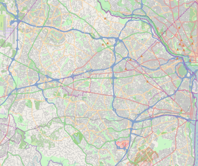
According to the U.S. Census Bureau, the county has an area of 406 square miles (1,050 km2), of which 391 square miles (1,010 km2) is land and 15 square miles (39 km2) (3.8%) is water.[14]
Fairfax County is bounded on the north and southeast by the Potomac River. Across the river to the northeast is Washington, D.C., across the river to the north is Montgomery County, Maryland, and across the river to the southeast are Prince George's County, Maryland and Charles County, Maryland. The county is partially bounded on the north and east by Arlington County and the independent cities of Alexandria and Falls Church. It is bounded on the west by Loudoun County, and on the south by Prince William County.
Most of the county lies in the Piedmont region, with rolling hills and deep stream valleys, such as Difficult Run and its tributaries. West of Route 28, the hills give way to a flat, gentle valley that stretches west to the Bull Run Mountains in Loudoun County. Elevations in the county range from near sea level along the tidal sections of the Potomac River in the southeast portion of the county to more than 500 feet (150 m) in the Tysons area.
Adjacent jurisdictions
- Alexandria – east
- Arlington County – east
- Charles County, Maryland – southeast
- Fairfax – surrounded by Fairfax County
- Falls Church – east
- Loudoun County – northwest
- Montgomery County, Maryland – north
- Prince George's County, Maryland – east
- Prince William County – southwest
Geology
The Piedmont hills in the central county are made up of ancient metamorphic rocks such as schist, the roots of several ancestral ranges of the Appalachian Mountains. The western valley is floored with more recent shale and sandstone. This geology is similar to adjacent bands of rocks in Maryland and further south in Virginia along the eastern front of the Appalachian.
An area of 11 square miles (30 km2) of the county is known to be underlain with natural asbestos.[15] Much of the asbestos is known to emanate from fibrous tremolite or actinolite. The threat was discovered in 1987, prompting the county to establish laws to monitor air quality at construction sites, control soil taken from affected areas, and require freshly developed sites to lay 6 inches (150 mm) of clean, stable material over the ground.[16][17]
During the construction of Centreville High School, for instance, a large amount of asbestos-laden soil was removed and then trucked to Vienna for the construction of the I-66/Nutley Street interchange. Fill dirt then had to be trucked in to make the site level.[citation needed] Marine clays can be found in widespread areas of the county east of Interstate 95, mostly in the Lee and Mount Vernon districts. These clays contribute to soil instability, leading to significant construction challenges for builders.[18]
Government and politics
This section needs additional citations for verification. (June 2024) |
Fairfax County uses the urban county executive form of government, which county voters approved in a 1966 referendum.[19][20] Under the urban county executive plan, the county is governed by the 10-member Fairfax County Board of Supervisors with the day-to-day running of the county tasked to the appointed Fairfax County executive. Nine of the board members are elected from the single-member districts of Braddock, Dranesville, Franconia, Hunter Mill, Mason, Mount Vernon, Providence, Springfield, and Sully, while the chairman is elected at-large.[citation needed]
In addition to the Board of Supervisors, three constitutional officers, the Commonwealth's Attorney, clerk of the Circuit Court, and sheriff. The Fairfax County School Board has 12 members that are directly elected by the voters of Fairfax County. Fairfax County also has a Consumer Protection Commission. The Commission advises the Board of Supervisors and the Department of Cable and Consumer Services on consumer affairs, investigates illegal, fraudulent, deceptive, or dangerous consumer practices, and refers apparent violations of Virginia law to the Commonwealth Attorney or County Attorney for investigation.[21]
The Fairfax County Government Center is west of the City of Fairfax in an unincorporated area.[22] Fairfax County contains an exclave unincorporated area in the City of Fairfax's central business district, where many county facilities (including the courthouses and jail) are.[23][24]
Fairfax County was once considered a Republican bastion but Democrats now control of the Board of Supervisors and the School Board (officially nonpartisan) as well as the offices of sheriff and Commonwealth's Attorney. Democrats also hold all the Fairfax seats in the Virginia House of Delegates and every seat in the Senate.[citation needed]
Fairfax County encompasses parts of three congressional districts, the 8th District, the 10th District, and the 11th District. Democrats represent all three districts, with Jennifer Wexton representing the 10th, Don Beyer representing the 8th, and Gerry Connolly representing the 11th.
In the 2012 general election, Fairfax County solidly backed Obama for reelection as president, who came just short of matching his 2008 performance, winning the county 59.6% to 39.1%. Former Governor Tim Kaine, running for the U.S. Senate in 2012, carried Fairfax County with 61% of the vote as part of his statewide victory. Representatives Connolly, Moran, and Wolf were also reelected.
Although Republican governor Bob McDonnell won Fairfax County with 51% of the vote in 2009, the Republican resurgence in Fairfax was short-lived. In the 2013 election, Democratic gubernatorial candidate Terry McAuliffe won Fairfax County with 58% of the vote, defeating incumbent state attorney general and former Republican state senator from Fairfax Ken Cuccinelli. McAuliffe's running mates, Ralph Northam and Mark Herring, also carried Fairfax County in their respective bids for lieutenant governor and attorney general. These Democratic victories mirrored the Democratic ticket's sweep of the state's three executive offices for the first time since 1989.
In the 2016 general election, Fairfax continued its trend towards Democratic candidates. Representatives Beyer and Connolly were reelected, the latter unopposed. Fairfax County supported Hillary Clinton for president with 64.4% of the vote to Donald Trump's 28.6%, exemplifying a heavy swing toward Democrats across Northern Virginia.
In the 2020 general election, Democratic presidential nominee Joe Biden won the county with 69.89% of the vote, the best percentage for a Democrat in the county since 1916.
| Year | Republican | Democratic | Third party | |||
|---|---|---|---|---|---|---|
| No. | % | No. | % | No. | % | |
| 2020 | 168,401 | 28.03% | 419,943 | 69.89% | 12,479 | 2.08% |
| 2016 | 157,710 | 28.61% | 355,133 | 64.43% | 38,340 | 6.96% |
| 2012 | 206,773 | 39.07% | 315,273 | 59.57% | 7,241 | 1.37% |
| 2008 | 200,994 | 38.93% | 310,359 | 60.12% | 4,901 | 0.95% |
| 2004 | 211,980 | 45.94% | 245,671 | 53.25% | 3,728 | 0.81% |
| 2000 | 202,181 | 48.86% | 196,501 | 47.49% | 15,093 | 3.65% |
| 1996 | 176,033 | 48.19% | 170,150 | 46.58% | 19,080 | 5.22% |
| 1992 | 170,488 | 44.26% | 160,186 | 41.58% | 54,544 | 14.16% |
| 1988 | 200,641 | 61.10% | 125,711 | 38.28% | 2,013 | 0.61% |
| 1984 | 183,181 | 62.88% | 107,295 | 36.83% | 822 | 0.28% |
| 1980 | 137,620 | 57.41% | 73,734 | 30.76% | 28,351 | 11.83% |
| 1976 | 110,424 | 53.62% | 92,037 | 44.69% | 3,496 | 1.70% |
| 1972 | 112,135 | 66.26% | 54,844 | 32.40% | 2,267 | 1.34%
Zdroj:https://en.wikipedia.org?pojem=South_Alexandria,_Virginia Text je dostupný za podmienok Creative Commons Attribution/Share-Alike License 3.0 Unported; prípadne za ďalších podmienok. Podrobnejšie informácie nájdete na stránke Podmienky použitia.
Analytika
Antropológia Aplikované vedy Bibliometria Dejiny vedy Encyklopédie Filozofia vedy Forenzné vedy Humanitné vedy Knižničná veda Kryogenika Kryptológia Kulturológia Literárna veda Medzidisciplinárne oblasti Metódy kvantitatívnej analýzy Metavedy Metodika Text je dostupný za podmienok Creative
Commons Attribution/Share-Alike License 3.0 Unported; prípadne za ďalších
podmienok. www.astronomia.sk | www.biologia.sk | www.botanika.sk | www.dejiny.sk | www.economy.sk | www.elektrotechnika.sk | www.estetika.sk | www.farmakologia.sk | www.filozofia.sk | Fyzika | www.futurologia.sk | www.genetika.sk | www.chemia.sk | www.lingvistika.sk | www.politologia.sk | www.psychologia.sk | www.sexuologia.sk | www.sociologia.sk | www.veda.sk I www.zoologia.sk |


