

A | B | C | D | E | F | G | H | CH | I | J | K | L | M | N | O | P | Q | R | S | T | U | V | W | X | Y | Z | 0 | 1 | 2 | 3 | 4 | 5 | 6 | 7 | 8 | 9
Sendai
仙台市 | |
|---|---|
From top left: Sendai Skyline, Aoba Castle, Sendai Tanabata Festival in Ichibanchō, Zuihōden, Sendai Station West Exit, Akiu Onsen, and SENDAI Pageant of Starlight | |
 Flag  Seal | |
| Nickname: City of Trees | |
 | |
 Location of Sendai in Miyagi Prefecture | |
 Sendai | |
| Coordinates: 38°16′5.6″N 140°52′9.9″E / 38.268222°N 140.869417°E | |
| Country | Japan |
| Region | Tōhoku |
| Prefecture | Miyagi |
| Government | |
| • Mayor | Kazuko Kōri |
| Area | |
| • Total | 786.30 km2 (303.59 sq mi) |
| Population (August 1, 2023) | |
| • Total | 1,098,335 |
| • Density | 1,400/km2 (3,600/sq mi) |
| Time zone | UTC+09:00 (Japan Standard Time) |
| Symbols | |
| • Tree | Japanese zelkova |
| • Flower | Japanese clover |
| Phone number | 022-261-1111 |
| Address | 3-7-1 Kokubun-cho, Aoba-ku, Sendai-shi, Miyagi-ken 980-8671 |
| Website | www |


| Sendai | |||||
|---|---|---|---|---|---|
| Japanese name | |||||
| Kanji | 仙台 | ||||
| Hiragana | せんだい | ||||
| Katakana | センダイ | ||||
| |||||
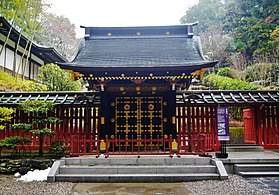
Sendai (仙台市, Sendai-shi, [seꜜndai] ) is the capital city of Miyagi Prefecture, the largest city in the Tōhoku region. As of 1 August 2023[update], the city had a population of 1,098,335 in 539,698 households,[1] and is one of Japan's 20 designated cities. The city was founded in 1600 by the daimyō Date Masamune. It is nicknamed the City of Trees (杜の都, Mori no Miyako); there are Japanese zelkova trees lining many of the main thoroughfares such as Jōzenji Street (定禅寺通, Jōzenji dōri) and Aoba Street (青葉通, Aoba dōri). In the summer, the Sendai Tanabata Festival, the largest Tanabata festival in Japan, is held. In winter, the trees are decorated with thousands of lights for the Pageant of Starlight (光のページェント, Hikari no pējento), lasting through most of December. The city is also home to Tohoku University, consistently ranked amongst the top institutions of higher education in Japan. On 11 March 2011, coastal areas of the city suffered catastrophic damage from a magnitude 9.0 offshore earthquake,[2][3][4] which triggered a destructive tsunami.[5]
History
Edo period
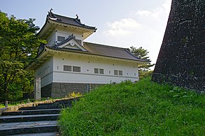
Although the Sendai area was inhabited as early as 20,000 years ago, the history of Sendai as a city begins from 1600, when the daimyō Date Masamune relocated. Masamune was not happy with his previous stronghold, Iwadeyama, which was located in the northern portion of his territories and was difficult to access from Edo (modern-day Tokyo). Sendai was an ideal location, being in the centre of Masamune's newly defined territories, upon the major road from Edo. Tokugawa Ieyasu gave Masamune permission to build a new castle in Aobayama after the Battle of Sekigahara. The previous ruler of the Sendai area had used a castle located on Aobayama. At this time Sendai was written as 千代 ("a thousand generations"), because a temple with a thousand Buddha statues (千体, sentai) used to be located in Aobayama. Masamune changed the kanji to "仙臺", which later became "仙台" (literally: "hermit/wizard" plus "platform/plateau" or figuratively, "hermit on a platform/high ground"). The character came from a Chinese poem that praised a palace created by the Emperor Wen of Han China (reigned 180–157 BCE), comparing it to a mythical palace in the Kunlun Mountains. Tradition says that Masamune chose this kanji so that the castle would prosper as long as a mountain inhabited by an immortal hermit.
Masamune ordered the construction of Sendai Castle in December 1600 and the construction of the surrounding castle town in 1601. The grid plan roads in modern-day central Sendai are based upon his plans.
- Gallery
-
-
 Map of the Area around Sendai Castle
 -
-


Modern era
The first railway line between Sendai and Tokyo, now the Tōhoku Main Line, opened in 1887, bringing the area within a day's travel from Tokyo for the first time in history. Tohoku Imperial University, the region's first university, was founded in Sendai in 1907 and became the first Japanese university to admit female students in 1913.
Sendai was incorporated as a city on 1 April 1889, with the post-Meiji restoration creation of the modern municipalities system following the abolition of the han system. At the time of incorporation, the city's area was 17.45 square kilometres (6.74 sq mi) and its population was 86,000. The city grew, however, through seven annexations that occurred between 1928 and 1988. The city became a designated city on 1 April 1989; the city's population exceeded one million in 1999.
Sendai was considered to be one of Japan's greenest cities, mostly because of its great numbers of trees and plants. Sendai became known as The City of Trees before the Meiji Restoration, after the feudal Sendai Domain encouraged residents to plant trees in their gardens. As a result, many houses, temples, and shrines in central Sendai had household forests (屋敷林, yashikirin), which were used as resources for wood and other everyday materials.
In 1925, the Senseki Line to Sendai Station became the first underground railway segment in Japan, preceding the opening of the Tokyo Metro Ginza Line (Asia's first subway line) by two years.
The 2nd Infantry Division was known as the "Sendai Division" as it was based in Sendai, and recruited locally. During the Second World War it was involved in many different campaigns, but one of the most important was the Battle of Guadalcanal. During the bombing of Sendai during World War II by the United States on 10 July 1945, much of the historic center of the city was burned, with 2,755 inhabitants killed and 11,933 houses destroyed in the city.
- Gallery
-
 A city map of 1927, Japanese language edition
 -

-
 Basho no Tsuji (1930)
 -

-
 Tohoku University Katahira Campus


Postwar development
Following World War II, the city was rebuilt, and Sendai became a vital transportation and logistics hub for the Tōhoku region with the construction of major arteries such as the Tōhoku Expressway and Tōhoku Shinkansen.
In the early 1950s, the United States Army, Japan operated Camp Schimmelpfennig and Camp Sendai in the city.
Sendai has been subject to several major earthquakes in recent history, including the 1978 Miyagi earthquake, which was a catalyst for the development of Japan's current earthquake resistance standards, and the 2005 Miyagi earthquake. Most recently, the coastal area of Sendai, including Sendai Airport, was severely damaged in the 2011 Tōhoku earthquake and tsunami.[2][3][4][6][7] The tsunami reportedly reached as far as Wakabayashi Ward Office, 8 kilometers (5.0 mi) from the coastline. Thousands were killed, and countless more were injured and/or made homeless. Sendai's port was heavily damaged and temporarily closed, reopening on 16 April 2011.[8]
- Gallery
-
 Sendai City War Reconstruction Memorial Hall
 -
 An aerial view of Sendai harbour after the earthquake, 12 March 2011
 -
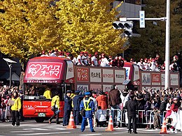 Tohoku Rakuten Golden Eagles (2013)


Geography
Sendai is located at lat. 38°16'05" north, long. 140°52'11" east. The city's area is 788.09 km2 (304.28 sq mi), and stretches from the Pacific Ocean to the Ōu Mountains, which are the east and west borders of Miyagi Prefecture. As a result, the city's geography is quite diverse. Eastern Sendai is a plains area, the center of the city is hilly, and western areas are mountainous. The highest point in the city is Mount Funagata which stands 1,500 metres (4,921 feet) above sea level. Unique among Japan's large coastal cities, Sendai's city core is built on a terrace at 40–60 m (131–197 ft) elevation.
The Sendai basin area is 939 km2 (363 sq mi) (the mountainous area is 675 km2 (261 sq mi), the plain area is 245 km2 (95 sq mi) and the water body is 20 km2 (8 sq mi)). The basin consists of urban areas, paddy fields and forests. The mid and upstream areas have forests. The Natori River flows through the area and reaches Sendai Bay after 55 km (34 mi).[9]
The Hirose River (広瀬川, Hirose-gawa) flows 45 kilometres (28 miles) through Sendai. The river is well known as a symbol of Sendai, especially because it appears in the lyrics of Aoba-jō Koi-uta (青葉城恋唄; literally, The Aoba Castle Love Song), a popular song sung by Muneyuki Satō. Aoba Castle was built close to the river to use the river as a natural moat. The river frequently flooded until the 1950s, but dams and levees constructed in the 1960s and 1970s have made such floods rare.
Most mountains in Sendai are dormant volcanoes, much older than the more famous Mount Zaō and Naruko volcanoes in nearby municipalities. However, many hot springs can be found in the city, indicating hydrothermal activity. The Miyagi Oki earthquake occurs offshore Sendai once every 25 to 40 years. The 7.2 magnitude 2005 Miyagi earthquake, which occurred on August 16, 2005, had an epicenter close to the Miyagi Oki earthquake area. However, the Headquarters for Earthquake Research Promotion concluded that it was not the Miyagi Oki earthquake, saying "...the recent event is not thought to be this earthquake. This is because the magnitude of the earthquake was small, and the source area, which was estimated from the aftershock distribution and seismic waves, didn't cover the whole expected source region. Although, the recent event ruptured a part of the focal region of the expected earthquake."[10] In 2011, the 9.0 magnitude 2011 Tōhoku earthquake occurred offshore Sendai, resulting in a devastating tsunami.
Wards
Sendai has five wards ("ku"), which were created when it became a designated city in 1989. The city consciously avoided names that included directions (e.g., north 北, center 中央) when it chose names for the new wards.
| Wards of Sendai | |||||||
|---|---|---|---|---|---|---|---|
| Place Name | Map of Sendai | ||||||
| Rōmaji | Kanji | Color | Population | Land area in km2 | Pop. density
per km2 |
||
| 1 | Aoba-ku - (administrative center) | 青葉区 |
|
296,551 | 302.278 | 981 |  |
| 2 | Izumi-ku | 泉区 |
|
215,048 | 146.61 | 1,470 | |
| 3 | Miyagino-ku |
宮城野区 | 196,086 | 58,19 | 3,370 | ||
| 4 | Taihaku-ku | 太白区 |
|
226,069 | 228.39 | 997 | |
| 5 | Wakabayashi-ku | 若林区 | 137,494 | 50.86 | 2,700 | ||
Cityscape
- Gallery
-
 View of Sendai from AER (2019)
 -
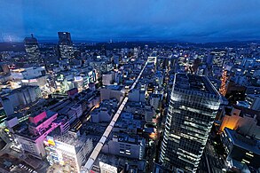
 Sendai night skyline from Mukaiyama (2012)
 -
 Sendai Station (2021)
 -
 Kokubunchō (2010)
 -
 Kōtōdai Park (2007)


Climate
Sendai has a humid subtropical climate (Köppen Cfa), which features warm and wet summers, and cool and dry winters. Sendai summers are not as hot as Tokyo to the south, while the winters are much milder than Sapporo to the north, but retains significant seasonal differences in temperature and rainfall. Extremes range from −11.7 to 37.2 °C (10.9 to 99.0 °F). Of Japan's prefectural capitals, Sendai experiences the fewest days of extreme temperatures (highs outside 0–30 °C (32–86 °F)) at 19.6 per year, compared to Tokyo's average of 49.
Winters are cool and relatively dry, with January temperatures averaging 1.5 °C (34.7 °F). Snowfall is much lower than cities on the Sea of Japan coast, such as Niigata and Tottori. Summers are very warm and much of the year's precipitation is delivered at this time, with an August average of 24.1 °C (75.4 °F). The city is rarely hit by typhoons, and experiences only 6 days with more than 10 centimetres (4 in) of rainfall on average. Sendai's monsoon season usually begins in late April to early October, which is later than in most cities in Japan. During this season, cold winds from the Okhotsk air mass, called "Yamase", blow in and depress daytime highs.[11]