

A | B | C | D | E | F | G | H | CH | I | J | K | L | M | N | O | P | Q | R | S | T | U | V | W | X | Y | Z | 0 | 1 | 2 | 3 | 4 | 5 | 6 | 7 | 8 | 9
The Somerset Portal

Somerset (/ˈsʌmərsɪt, -sɛt/ SUM-ər-sit, -set; archaically Somersetshire /ˈsʌmərsɪt.ʃɪər, -sɛt-, -ʃər/ SUM-ər-sit-sheer, -set-, -shər) is a ceremonial county in South West England. It is bordered by the Bristol Channel, Gloucestershire, and Bristol to the north, Wiltshire to the east and the north-east, Dorset to the south-east, and Devon to the south-west. The largest settlement is the city of Bath, and the county town is Taunton.
Somerset is a predominantly rural county, especially to the south and west, with an area of 4,171 km2 (1,610 sq mi) and a population of 965,424. After Bath (101,557), the largest settlements are Weston-super-Mare (82,418), Taunton (60,479), Yeovil (49,698) and Frome (28,559). Wells (12,000) is a city, the second-smallest by population in England. For local government purposes the county comprises three unitary authority areas: Bath and North East Somerset, North Somerset, and Somerset. Bath and North East Somerset Council is a member of the West of England Combined Authority.
The centre of Somerset is dominated by the Levels, a coastal plain and wetland. The north-east contains part of the Cotswolds uplands and all of the Mendip Hills, which are both national landscapes; the west contains the Quantock Hills and part of the Blackdown Hills, which are also national landscapes, and most of Exmoor, a national park. The major rivers of the county are the Avon, which flows through Bath and then Bristol, and the Axe, Brue, and Parrett, which drain the Levels.
There is evidence of Paleolithic human occupation in Somerset, and the area was subsequently settled by the Celts, Romans and Anglo-Saxons. The county played a significant part in Alfred the Great's rise to power, and later the English Civil War and the Monmouth Rebellion. In the later medieval period its wealth allowed its monasteries and parish churches to be rebuilt in grand style; Glastonbury Abbey was particularly important, and claimed to house the tomb of King Arthur and Guinevere. The city of Bath is famous for its Georgian architecture, and is a UNESCO World Heritage Site. The county is also the location of Glastonbury Festival, one of the UK's major music festivals. (Full article...)
Selected article

The hills are largely carboniferous limestone, which is quarried at several sites. The higher western part of the Hills have been designated as an Area of Outstanding Natural Beauty (AONB), with an area of 200 km2 (80 sq mi), which gives it the same level of protection as a national park. The Mendip Hills AONB Service and Somerset County Council's outdoor education centre is at the Charterhouse Centre near Blagdon.
The Mendips are home to a wide range of outdoor sports and leisure activities, many based on the particular geology of the area. It is recognised as a national centre for caving and cave diving. In addition to climbing and abseiling, the area is popular with hillwalkers and those interested in natural history. (Full article...)
Selected biography -
.jpg)
Districts of Somerset

- Somerset (Unitary)
- North Somerset (Unitary)
- Bath and North East Somerset (Unitary)
Subcategories

Related portals
Selected images
-

-
-
 Stone quarries are still a major employer in Somerset (from Somerset)
 -
 Tyntesfield (from Somerset)
 -
 The town of Glastonbury looking west from the top of Glastonbury Tor. The fields in the distance are the Somerset Levels. (from Somerset)
 -
 The Exmoor landscape with the native Exmoor Pony (from Somerset)
 -
 The Dunster Yarn Market was built in 1609 for the trading of local cloth. (from Somerset)
 -
 Weston-super-Mare Town Hall, the administrative headquarters of North Somerset (from Somerset)
 -
 A steam locomotive and carriages, on the West Somerset Railway, a heritage line of notable length, in spring 2015 (from Somerset)
 -
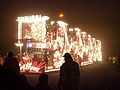 "Samurai" by Griffens CC, at Burnham on Sea Carnival 2006, part of the West Country Carnival circuit (from Culture of Somerset)
 -
 A traditional cider apple orchard at Over Stratton, with sheep grazing (from Somerset)
 -
Tyntesfield. (from Culture of Somerset)
-
 Sand Sculpture at Weston-super-Mare Sand Sculpture Festival of A Midsummer Nights Dream (from Culture of Somerset)
 -
 The Avon Gorge, the historic boundary between Gloucestershire and Somerset, and also Mercia and Wessex; Somerset is to the left (from Somerset)
 -
 Brewhouse Theatre, Taunton (from Culture of Somerset)
 -
 The ceremonial county immediately prior to the 2023 local government restructuring, with South Somerset (1), Somerset West and Taunton (2), Sedgemoor (3) and Mendip (4) as non-metropolitan districts (shown in pink), and just Bath and North East Somerset (5), and North Somerset (6) as unitary authorities (shown in yellow). (from Somerset)
 -
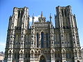 The west front of Wells Cathedral (from Somerset)
 -
 A map of the county in 1646, author unknown (from Somerset)
 -
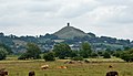 Glastonbury Tor (from Culture of Somerset)
 -

-
-
 Brean Down from Steep Holm (from Somerset)
 -

-
 The flag designed to represent the historic county of Somerset in 2013 (from Somerset)
 -
 Bristol Airport, which is located in North Somerset (from Somerset)
 -
The west front of Wells Cathedral (from Culture of Somerset)


_from_the_tor_arp.jpg)


_down_South_Wales_Pullman.JPG)


.jpg)


Selected settlement

Co-ordinates 51°17′34″N 2°26′52″W / 51.2927°N 2.4477°W
Radstock is a town 9 miles (14 km) south west of Bath, and 8 miles (13 km) north west of Frome. It is within the unitary authority of Bath and North East Somerset and has a population of 5,275 according to the 2001 Census. Together with neighbouring Midsomer Norton and the smaller settlements of Clandown, Westfield and Haydon, Radstock is part of the conurbation and civil parish of Norton Radstock.
Radstock has been settled since the Iron Age, and its importance grew after the construction of the Fosse Way, a Roman road. The growth of the town occurred after 1763, when coal was discovered in the area. Large numbers of mines opened during the 19th century including several owned by the Waldegrave family, who had been Lords of the Manor since the English Civil War. The spoil heap of Writhlington colliery is now the Writhlington Site of Special Scientific Interest, which includes 3,000 tons of Upper Carboniferous spoil from which more than 1,400 insect fossil specimens have been recovered. The complex geology and narrow seams made coal extraction difficult. Tonnage increased throughout the 19th century, reaching a peak around 1901, when there were 79 separate collieries and annual production was 1,250,000 tons per annum. However, due to local geological difficulties and manpower shortages output declined and the number of pits reduced from 30 at the beginning of the 20th century to 14 by the mid-thirties; the last two pits, Kilmersdon and Writhlington, closed in September 1973. The Great Western Railway and the Somerset and Dorset Railway both established stations and marshalling yards in the town. The last passenger train services to Radstock closed in 1966. Manufacturing industries such as printing, binding and packaging provide some local employment. In recent years, Radstock has increasingly become a commuter town for the nearby cities of Bath and Bristol.
Radstock is home to the Radstock Museum which is housed in a former market hall, and has a range of exhibits which offer an insight into north-east Somerset life since the 19th century. Many of the exhibits relate to local geology and the now disused Somerset coalfield and geology. The town is also home to Writhlington School, famous for its Orchid collection, and a range of educational, religious and cultural buildings and sporting clubs. (Full article...)
Did you know...
From Wikipedia's "Did You Know" archives:

- ... that medieval Perpendicular Gothic Somerset Towers typically feature pinnacles, lacy tracery windows and bell openings, gargoyles, arches, buttresses, merlons, and external stair turrets?
- ... that Gants Mill is an historic watermill now generating hydroelectric power from the River Brue?
- ... that the village of Selworthy was rebuilt by Sir Thomas Dyke Acland in 1828 as a Model village for the aged and infirm of his Holnicote Estate?
- ... that Midford Castle was built in the shape of the ace of clubs (♣)?
- ... that Porlock Bay in England contains a submerged forest?
Things you can do
 |
Here are some tasks awaiting attention:
|
WikiProjects
Nearby projects: WikiProject Bristol, WikiProject Devon, WikiProject Dorset, WikiProject Wiltshire
Topics
Recognised content
| This is a list of recognized content, updated weekly by JL-Bot (talk · contribs) (typically on Saturdays). There is no need to edit the list yourself. If an article is missing from the list, make sure it is tagged (e.g. {{WikiProject Somerset}}) or categorized correctly and wait for the next update. See WP:RECOG for configuration options. |
Featured articles
 Ælfheah of Canterbury
- Bath, Somerset
- Battle of Babylon Hill
- Battle of Marshall's Elm
- Margaret Bondfield
- Robert Burnell
- Chew Stoke
- Equestrian statue of Edward Horner
- Exmoor
- Ham Wall
- Herbie Hewett
- Kennet and Avon Canal
- Mells War Memorial
- Mendip Hills
- Lionel Palairet
- Porlock Stone Circle
- River Parrett
- Sieges of Taunton
- Somerset County Cricket Club in 1891
- Somerset County Cricket Club in 2009
- Somerset Levels
- Sweet Track
- Marcus Trescothick
- Wells Cathedral
- Withypool Stone Circle
Featured lists
- List of ecclesiastical parishes in the Diocese of Bath and Wells
- Works of Keith Floyd
- Grade I listed buildings in Bath and North East Somerset
- Grade I listed buildings in Mendip
- Grade I listed buildings in North Somerset
- Grade I listed buildings in Sedgemoor
- Grade I listed buildings in South Somerset
- Grade I listed buildings in Taunton Deane
- Grade I listed buildings in West Somerset
- Grade II* listed buildings in North Somerset
- List of civil parishes in Somerset
- List of English Heritage properties in Somerset
- List of locks on the Kennet and Avon Canal
- List of Sites of Special Scientific Interest in Avon
- List of Sites of Special Scientific Interest in Somerset
- List of Somerset County Cricket Club Twenty20 players
- List of Somerset County Cricket Club grounds
- List of Somerset County Cricket Club players with 100 or more first-class or List A appearances
- List of churches preserved by the Churches Conservation Trust in Southwest England
- List of hillforts and ancient settlements in Somerset
- List of local nature reserves in Somerset
- List of scheduled monuments in Bath and North East Somerset
- List of scheduled monuments in Mendip
- List of scheduled monuments in North Somerset
- List of scheduled monuments in Sedgemoor
- List of scheduled monuments in South Somerset
- List of scheduled monuments in Taunton Deane
- Grade II* listed buildings in Mendip
- List of museums in Somerset
- List of national nature reserves in Somerset
- List of National Trust properties in Somerset
- List of scheduled monuments in West Somerset (A–G)
- List of scheduled monuments in West Somerset (H–Z)
- Grade II* listed buildings in Sedgemoor
- Grade II* listed buildings in Taunton Deane
- Grade II* listed buildings in West Somerset
Featured topics
Good articles
 A303 road
- 1754 Taunton by-election
- 1887 Taunton by-election
- The Abbot's Fish House, Meare
- Agapemonites
- William Arnold (settler)
- Ashton Court
- Ashton Court Festival
- Athelm
- River Avon, Bristol
- Avon Gorge
- Herbert E. Balch
- Barrington Court
- E. W. Bastard
- Bath Abbey
- Bath Assembly Rooms
- Beckford's Tower
- Berhtwald
- Birnbeck Pier
- Bishop's Palace, Wells
- Blackdown Hills National Landscape
- Blagdon Lake
- John Braham (RAF officer)
- Brean Down
- HMS Bridgewater (L01)
- Bridgwater and Taunton Canal
- Bridgwater Bay
- Bridgwater
- Brislington House
- Bruton Dovecote
- Buildings and architecture of Bath
- Burnham-on-Sea
- Mike Burns (cricketer)
- Buro Happold
- Burrow Mump
- Burton Pynsent House
- Jenson Button
- Allegra Byron
- Cadbury Camp
- Cadbury Castle, Somerset
- Chard, Somerset
- Cheddar Gorge
- Cheddar, Somerset
- Chew Magna
- St Andrew's Church, Chew Stoke
- Claverton Pumping Station
- Cleeve Abbey
- Clevedon
- Clevedon Court
- Clevedon Pier
- Cleveland Pools
- Clifton Suspension Bridge
- Climate of south-west England
- Coleridge Cottage
- The Crescent, Taunton
- Crewkerne
- Cricket at the 1900 Summer Olympics
- Crook Peak to Shute Shelve Hill
- Dolebury Warren
- Dovecot at Blackford Farm
- Dunkery Hill
- Dunstan
- Dunster Butter Cross
- Dunster Castle
- Dunster
- Dunster Working Watermill
- Ebbor Gorge
- Exmoor pony
- Farleigh Hungerford Castle
- Reginald Fitz Jocelin
- Savaric FitzGeldewin
- Henry Fownes Luttrell (died 1780)
- Henry Fox (sportsman)
- Frome
- Fyne Court
- Gallox Bridge, Dunster
- Edith Garrud
- Geography of Somerset
- Geology of Somerset
- Gisa (bishop of Wells)
- Eleanor Glanville
- Glastonbury Abbey
- Glastonbury Canal
- Glastonbury Festival
- Glastonbury
- Glastonbury Lake Village
- Glastonbury Tor
- Grade I listed buildings in Somerset
- Grand Western Canal
- HM Prison Shepton Mallet
- Hestercombe House
- James Hill (British Army officer)
- Sidney Hill
- History of Somerset
- Holnicote Estate
- Hot Fuzz
- Jocelin of Wells
- John of Tours
- Keynsham
- King Alfred's Tower
- King John's Hunting Lodge, Axbridge
- Scott Laird
- Leigh Court
- Leigh Woods National Nature Reserve
- Long Ashton railway station
- Lyfing (archbishop of Canterbury)
- Lytes Cary
- Masonic Hall, Taunton
- Midsomer Norton
- Minehead
- Monmouth Rebellion
- Montacute House
- Muchelney Abbey
- Nailsea Court
- Nailsea
- Nailsea and Backwell railway station
- Nettlecombe Court
- Stephen Newton
- Tom Nichols (footballer)
- Nunney Castle
- Pill railway station
- PinkPantheress
- Portishead, Somerset
- Massey Poyntz
- The Priest's House, Muchelney
- Prior Park Landscape Garden
- Prior Park
- Pulteney Bridge
- Quantock Hills
- Radstock
- River Brue
- River Tone
- Robert of Bath
- Roman Baths (Bath)
- Royal Crescent
- Ted Sainsbury
- St Catherine's Court
- Sand Point and Middle Hope
- Scheduled monuments in Somerset
- Jake Seamer
- Shepton Mallet
- Sigeric (bishop)
- Sir Bevil Grenville's Monument
- Solsbury Hill
- Somerset Coal Canal
- Somerset Coalfield
- Somerset County Cricket Club in 1882
- Somerset County Cricket Club in 1885
- Somerton, Somerset
- Stanton Drew stone circles
Zdroj:https://en.wikipedia.org?pojem=Portal:Somerset
Text je dostupný za podmienok Creative Commons Attribution/Share-Alike License 3.0 Unported; prípadne za ďalších podmienok. Podrobnejšie informácie nájdete na stránke Podmienky použitia.
Antropológia
Aplikované vedy
Bibliometria
Dejiny vedy
Encyklopédie
Filozofia vedy
Forenzné vedy
Humanitné vedy
Knižničná veda
Kryogenika
Kryptológia
Kulturológia
Literárna veda
Medzidisciplinárne oblasti
Metódy kvantitatívnej analýzy
Metavedy
Metodika
Text je dostupný za podmienok Creative
Commons Attribution/Share-Alike License 3.0 Unported; prípadne za ďalších
podmienok.
Podrobnejšie informácie nájdete na stránke Podmienky
použitia.
www.astronomia.sk | www.biologia.sk | www.botanika.sk | www.dejiny.sk | www.economy.sk | www.elektrotechnika.sk | www.estetika.sk | www.farmakologia.sk | www.filozofia.sk | Fyzika | www.futurologia.sk | www.genetika.sk | www.chemia.sk | www.lingvistika.sk | www.politologia.sk | www.psychologia.sk | www.sexuologia.sk | www.sociologia.sk | www.veda.sk I www.zoologia.sk