

A | B | C | D | E | F | G | H | CH | I | J | K | L | M | N | O | P | Q | R | S | T | U | V | W | X | Y | Z | 0 | 1 | 2 | 3 | 4 | 5 | 6 | 7 | 8 | 9


Odisha (English: /əˈdɪsə/,[16] Odia: [oɽiˈsa] ), formerly Orissa (/ɒˈrɪsə, ɔː-, oʊ-/[17] the official name until 2011), is an Indian state located in Eastern India. It is the eighth-largest state by area, and the eleventh-largest by population, with over 41 million inhabitants. The state also has the third-largest population of Scheduled Tribes in India.[18] It neighbours the states of Jharkhand and West Bengal to the north, Chhattisgarh to the west, and Andhra Pradesh and Telangana to the south. Odisha has a coastline of 485 kilometres (301 mi) along the Bay of Bengal in Indian Ocean.[19] The region is also known as Utkaḷa and is mentioned by this name in India's national anthem, Jana Gana Mana.[20] The language of Odisha is Odia, which is one of the Classical languages of India.[21]
The ancient kingdom of Kalinga, which was invaded by the Mauryan Emperor Ashoka in 261 BCE resulting in the Kalinga War, coincides with the borders of modern-day Odisha.[22] The modern boundaries of Odisha were demarcated by the Indian government when Orissa Province was established on 1 April 1936, consisting of the Odia-speaking districts of Bihar and Orissa Province.[22] The 1st of April is celebrated as Utkala Dibasa (lit. 'Odisha Day').[23] Cuttack was made the capital of the region by Anantavarman Chodaganga in c. 1135,[24] after which the city was used as the capital by many rulers, through the British era until 1948. Thereafter, Bhubaneswar became the capital of Odisha.[25] The economy of Odisha is the 16th-largest state economy in India with ₹5.86 trillion (US$73 billion) in gross domestic product and a per capita GDP of ₹127,383 (US$1,600).[5] Odisha ranks 32nd among Indian states in Human Development Index.[26]
Etymology
The terms Odisha and Orissa (Odia: ଓଡ଼ିଶା, Oṛissa) derive from the ancient Prakrit word "Odda Visaya" (also "Udra Bibhasha" or "Odra Bibhasha") as in the Tirumalai inscription of Rajendra Chola I, which is dated to 1025.[27] Sarala Das, who translated the Mahabharata into the Odia language in the 15th century, calls the region 'Odra Rashtra' as Odisha. The inscriptions of Kapilendra Deva of the Gajapati Kingdom (1435–67) on the walls of temples in Puri call the region Odisha or Odisha Rajya.[28]
In 2011, the English rendering of ଓଡ଼ିଶା was changed from "Orissa" to "Odisha", and the name of its language from "Oriya" to "Odia", by the passage of the Orissa (Alteration of Name) Bill, 2010 and the Constitution (113th Amendment) Bill, 2010 in the Parliament. The Hindi rendering उड़ीसा (uṛīsā) was also modified to ओड़िशा (or̥iśā). After a brief debate, the lower house, Lok Sabha, passed the bill and amendment on 9 November 2010.[29] On 24 March 2011, Rajya Sabha, the upper house of Parliament, also passed the bill and the amendment.[30] The changes in spelling were made with the intention of having the English and Hindi renditions conform to the Odia transliteration.[31] However, the underlying Odia texts were nevertheless transliterated incorrectly as per the Hunterian system, the official national transliteration standard, in which the transliterations would be Orisha and Oria instead.
History

Prehistoric Acheulian tools dating to Lower Paleolithic era have been discovered in various places in the region, implying an early settlement by humans.[32] Kalinga has been mentioned in ancient texts like Mahabharata, Vayu Purana and Mahagovinda Suttanta.[33][34]
According to political scientist Sudama Misra, the Kalinga janapada originally comprised the area covered by the Puri and Ganjam districts.[35] The Sabar people of Odisha have also been mentioned in the Mahabharata.[36][37] Baudhayana mentions Kalinga as not yet being influenced by Vedic traditions, implying it followed mostly tribal traditions.[38]


Ashoka of the Mauryan dynasty conquered Kalinga in the bloody Kalinga War in 261 BCE,[39] which was the eighth year of his reign.[40] According to his own edicts, in that war about 100,000 people were killed, 150,000 were captured and more were affected.[39] The resulting bloodshed and suffering of the war is said to have deeply affected Ashoka. He turned into a pacifist and converted to Buddhism.[40][41]
By c. 150 BCE, Emperor Kharavela, who was possibly a contemporary of Demetrius I of Bactria,[42] conquered a major part of the Indian sub-continent. Kharavela was a Jain ruler. He also built the monastery atop the Udayagiri hill.[43] Subsequently, the region was ruled by monarchs, such as Samudragupta[44] and Shashanka.[45] It was also a part of Harsha's empire.[46]
The city of Brahmapur in Odisha is also known to have been the capital of the Pauravas during the closing years of 4th century CE. Nothing was heard from the Pauravas from about the 3rd century CE, because they were annexed by the Yaudheya Republic, who in turn submitted to the Mauryans. It was only at the end of 4th century CE, that they established royalty at Brahmapur, after about 700 years.
Later, the kings of the Somavamsi dynasty began to unite the region. By the reign of Yayati II, c. 1025 CE, they had integrated the region into a single kingdom. Yayati II is supposed to have built the Lingaraj temple at Bhubaneswar.[22] They were replaced by the Eastern Ganga dynasty. Notable rulers of the dynasty were Anantavarman Chodaganga, who began reconstruction on the present-day Shri Jagannath Temple in Puri (c. 1135), and Narasimhadeva I, who constructed the Konark temple (c. 1250).[47][48]
The Eastern Ganga Dynasty was followed by the Gajapati Kingdom. The region resisted integration into the Mughal empire until 1568, when it was conquered by Sultanate of Bengal.[49] Mukunda Deva, who is considered the last independent king of Kalinga, was defeated and was killed in battle by a rebel Ramachandra Bhanja. Ramachandra Bhanja himself was killed by Bayazid Khan Karrani.[50] In 1591, Man Singh I, then governor of Bihar, led an army to take Odisha from the Karranis of Bengal. They agreed to treaty because their leader Qutlu Khan Lohani had recently died. But they then broke the treaty by attacking the temple town of Puri. Man Singh returned in 1592 and pacified the region.[51]
In 1751, the Nawab of Bengal Alivardi Khan ceded the region to the Maratha Empire.[22]
The British had occupied the Northern Circars, comprising the southern coast of Odisha, as a result of the Second Carnatic War by 1760, and incorporated them into the Madras Presidency gradually.[52] In 1803, the British ousted the Marathas from the Puri-Cuttack region of Odisha during the Second Anglo-Maratha War. The northern and western districts of Odisha were incorporated into the Bengal Presidency.[53]
The Orissa famine of 1866 caused an estimated 1 million deaths.[54] Following this, large-scale irrigation projects were undertaken.[55] In 1903, the Utkal Sammilani organisation was founded to demand the unification of Odia-speaking regions into one state.[56] On 1 April 1912, the Bihar and Orissa Province was formed.[57] On 1 April 1936, Bihar and Orissa were split into separate provinces.[58] The new province of Orissa came into existence on a linguistic basis during the British rule in India, with Sir John Austen Hubback as the first governor.[58][59] Following India's independence, on 15 August 1947, 27 princely states signed the document to join Orissa.[60] Most of the Orissa Tributary States, a group of princely states, acceded to Orissa in 1948, after the collapse of the Eastern States Union.[61]
Geography

Odisha lies between the latitudes 17.780N and 22.730N, and between longitudes 81.37E and 87.53E. The state has an area of 155,707 km2, which is 4.87% of total area of India, and a coastline of 450 km.[62] In the eastern part of the state lies the coastal plain. It extends from the Subarnarekha River in the north to the Rushikulya River in the south. The lake Chilika is part of the coastal plains. The plains are rich in fertile silt deposited by the six major rivers flowing into the Bay of Bengal: Subarnarekha, Budhabalanga, Baitarani, Brahmani, Mahanadi and Rushikulya.[62] The Central Rice Research Institute (CRRI), a Food and Agriculture Organization-recognised rice gene bank and research institute, is situated on the banks of Mahanadi in Cuttack.[63] The stretch between Puri and Bhadrak in Odisha juts out a little into the sea, making it vulnerable to any cyclonic activity.[64]

Three-quarters of the state is covered in mountain ranges. Deep and broad valleys have been made in them by rivers. These valleys have fertile soil and are densely populated. Odisha also has plateaus and rolling uplands, which have lower elevation than the plateaus.[62] The highest point in the state is Deomali at 1,672 metres in Koraput district. Some other high peaks are: Sinkaram (1,620 m), Golikoda (1,617 m), and Yendrika (1,582 metres).[65]
Climate
The state experiences four meteorological seasons: winter (January to February), pre-monsoon season (March to May), south-west monsoon season (June to September) and north east monsoon season (October–December). However, locally the year is divided into six traditional seasons (or rutus): Grishma (summer), Barsha (rainy season), Sharata (autumn), Hemanta (dewy),Sheeta(winter season) and Basanta (spring).[62]
| Mean Temp and Precipitation of Selected Weather Stations[66] | ||||||||||||
|---|---|---|---|---|---|---|---|---|---|---|---|---|
| Bhubaneswar (1952–2000) |
Balasore (1901–2000) |
Gopalpur (1901–2000) |
Sambalpur (1901–2000) | |||||||||
| Max (°C) | Min (°C) | Rainfall (mm) | Max (°C) | Min (°C) | Rainfall (mm) | Max (°C) | Min (°C) | Rainfall (mm) | Max (°C) | Min (°C) | Rainfall (mm) | |
| January | 28.5 | 15.5 | 13.1 | 27.0 | 13.9 | 17.0 | 27.2 | 16.9 | 11.0 | 27.6 | 12.6 | 14.2 |
| February | 31.6 | 18.6 | 25.5 | 29.5 | 16.7 | 36.3 | 28.9 | 19.5 | 23.6 | 30.1 | 15.1 | 28.0 |
| March | 35.1 | 22.3 | 25.2 | 33.7 | 21.0 | 39.4 | 30.7 | 22.6 | 18.1 | 35.0 | 19.0 | 20.9 |
| April | 37.2 | 25.1 | 30.8 | 36.0 | 24.4 | 54.8 | 31.2 | 25.0 | 20.3 | 39.3 | 23.5 | 14.2 |
| May | 37.5 | 26.5 | 68.2 | 36.1 | 26.0 | 108.6 | 32.4 | 26.7 | 53.8 | 41.4 | 27.0 | 22.7 |
| June | 35.2 | 26.1 | 204.9 | 34.2 | 26.2 | 233.4 | 32.3 | 26.8 | 138.1 | 36.9 | 26.7 | 218.9 |
| July | 32.0 | 25.2 | 326.2 | 31.8 | 25.8 | 297.9 | 31.0 | 26.1 | 174.6 | 31.1 | 24.9 | 459.0 |
| August | 31.6 | 25.1 | 366.8 | 31.4 | 25.8 | 318.3 | 31.2 | 25.9 | 195.9 | 30.7 | 24.8 | 487.5 |
| September | 31.9 | 24.8 | 256.3 | 31.7 | 25.5 | 275.8 | 31.7 | 25.7 | 192.0 | 31.7 | 24.6 | 243.5 |
| October | 31.7 | 23.0 | 190.7 | 31.3 | 23.0 | 184.0 | 31.4 | 23.8 | 237.8 | 31.7 | 21.8 | 56.6 |
| November | 30.2 | 18.8 | 41.7 | 29.2 | 17.8 | 41.6 | 29.5 | 19.7 | 95.3 | 29.4 | 16.2 | 17.6 |
| December | 28.3 | 15.2 | 4.9 | 26.9 | 13.7 | 6.5 | 27.4 | 16.4 | 11.4 | 27.2 | 12.1 | 4.8 |
Biodiversity
According to a Forest Survey of India report released in 2012, Odisha has 48,903 km2 of wild forest, covering 31.41% of the state's total area. The forests are classified into areas of dense forest (7,060 km2), medium dense forest (21,366 km2), open forest (forest without closed canopy; 20,477 km2) and scrub forest or scrubland (4,734 km2). The state also has bamboo forests (10,518 km2) and tidal areas of mangrove swamp (221 km2). The state is gradually losing its wilderness areas to timber smuggling, deforestation, destructive mining, and general urban industrialisation, as well as livestock grazing. There have been attempts at conservation and reforestation.[67]
Due to the climate and good rainfall, Odisha's evergreen and moist forests are uniquely suitable habitats for wild orchids. Around 130 species have been reported from the state.[68] Around 97 of them are found in Mayurbhanj district alone. The Orchid House of the Nandankanan Zoological Park maintains some of these species.[69]
Simlipal National Park is a protected wildlife area and Bengal tiger reserve spread over 2,750 km2 of the northern part of Mayurbhanj district. The park has around 1,078 species of plants, including 94 of the aforementioned orchids. The sal is the primary tree species. For fauna, the park is home to around 55 species of mammal, including the Bengal tiger, chital, chousingha, common langur, gaur, Indian elephant, Indian giant squirrel, jungle cat, leopard, muntjac, sambar, small Indian civet and wild boar. There are over 300 species of birds in the park, such as the common hill myna, as well as grey, Indian pied and Malabar pied hornbills. There are also some 60 species of reptiles and amphibians, including the famed king cobra, plus banded krait and tricarinate hill turtle. There is also a mugger crocodile breeding programme in nearby Ramtirtha.[70]
The Chandaka Elephant Sanctuary is a 190 km2 protected area near the capital city, Bhubaneswar. However, urban expansion and over-grazing have reduced the forests, driving the herds of elephants to migrate away, as well as increasing human-elephant conflicts—which sometimes results in injury and death (on both sides). Some elephants have died in conflicts with villagers, while some have died during migration after being accidentally electrocuted by power lines or even hit by trains. Outside the protected area, they are killed by ivory poachers. In 2002, there were about 80 elephants, but by 2012, their numbers had been reduced to 20. Many of the animals have migrated toward the Barbara Reserve forest, Chilika, Nayagarh district, and Athagad.[71][72] Besides elephants, the sanctuary also has leopards, jungle cats and herds of chital.[73]
The Bhitarkanika National Park in Kendrapara district covers 650 km2, of which 150 km2 are mangroves. Gahirmatha Beach, in Bhitarkanika, is the world's largest nesting site for olive ridley sea turtles.[74] In 2013, the Indian Coast Guard initiated Operation Oliver to protect the endangered sea turtle population of the region.[75] Other major nesting grounds for the turtle in the state are Rushikulya, in Ganjam district,[76] and the mouth of the Devi river.[77] The Bhitarkanika sanctuary is also noted for its large population of saltwater crocodiles and Asian water monitors,[78] the second-largest lizard species on earth,[79] in addition to axis deer and rhesus macaques.[78] The coastal mangrove environments are home to several types of mudskippers, including the barred, Boddart's blue-spotted and great blue-spotted mudskippers.[78]
In winter, Bhitarkanika is also visited by migratory birds. Among the many species, both resident and migratory, are kingfishers (including black-capped, collared and common kingfishers), herons (such as black-crowned night, grey, purple and striated herons), Indian cormorants, openbill storks, Oriental white ibis, pheasant-tailed jacana, sarus cranes, spotted owlets and white-bellied sea-eagles.[80][78] The possibly endangered horseshoe crab is also found in this region.[81]
Chilika Lake is a brackish water lagoon on the east coast of Odisha with an area of 1,105 km2. It is connected to the Bay of Bengal by a 35-km-long narrow channel and is a part of the Mahanadi delta. In the dry season, the tides bring in salt water. In the rainy season, the rivers falling into the lagoon decrease its salinity.[82] Birds from places as far as the Caspian Sea, Lake Baikal (and other parts of Russia), Central Asia, Southeast Asia, Ladakh and the Himalayas migrate to the lagoon in winter.[83] Among the waterfowl and wading birds spotted there are Eurasian wigeon, pintail, bar-headed goose, greylag goose, greater flamingo, common mallard and Goliath heron.[84][85] The lagoon also has a small population of the endangered Irrawaddy dolphins.[86] The state's coastal region has also had sightings of the rare finless porpoise, as well as the more common bottlenose dolphin, humpback dolphin and spinner dolphins in its waters.[87]
Satapada is situated close to the northeast cape of Chilika Lake and Bay of Bengal. It is famous for dolphin watching in their natural habitat. There is a tiny island en route for watching dolphins, where tourists often take a short stop. Apart from that, this island is also home for tiny red crabs.
According to a census conducted in 2016, there are around 2000 elephants in the state. [88]
-
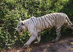 White tiger in the Nandankanan Zoo
 -
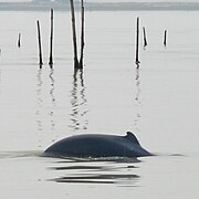 Irrawaddy dolphins can be found in Chilika
 -
 Vanda tessellata, one of the orchids found in Odisha[89]
 -
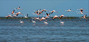 Migratory birds at Chilika Lake
 -
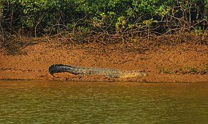 Crocodile in Bhitarkanika National Park


Government and politics

All states in India are governed by a parliamentary system of government based on universal adult franchise.[90][91]
The main parties active in the politics of Odisha are the Biju Janata Dal, the Indian National Congress and Bharatiya Janata Party. Following the Odisha State Assembly Election in 2019, the Naveen Patnaik-led Biju Janata Dal stayed in power for the sixth consecutive term, he is the 14th chief minister of Odisha since 2000.[92]
Legislative assembly
The Odisha state has a unicameral legislature.[93] The Odisha Legislative Assembly consists of 147 elected members,[92] and special office bearers such as the Speaker and Deputy Speaker, who are elected by the members. Assembly meetings are presided over by the Speaker, or by the Deputy Speaker in the Speaker's absence.[94] Executive authority is vested in the Council of Ministers headed by the Chief Minister, although the titular head of government is the Governor of Odisha. The governor is appointed by the President of India. The leader of the party or coalition with a majority in the Legislative Assembly is appointed as the Chief Minister by the governor, and the Council of Ministers are appointed by the governor on the advice of the Chief Minister. The Council of Ministers reports to the Legislative Assembly.[95] The 147 elected representatives are called Members of the Legislative Assembly, or MLAs. One MLA may be nominated from the Anglo-Indian community by the governor.[96] The term of the office is for five years, unless the Assembly is dissolved prior to the completion of the term.[94]
The judiciary is composed of the Odisha High Court, located at Cuttack, and a system of lower courts.
Subdivisions
Odisha has been divided into 30 districts. These 30 districts have been placed under three different revenue divisions to streamline their governance. The divisions are North, Central and South, with their headquarters at Sambalpur, Cuttack and Berhampur respectively. Each division consists of ten districts and has as its administrative head a Revenue Divisional Commissioner (RDC).[97] The position of the RDC in the administrative hierarchy is that between that of the district administration and the state secretariat.[98] The RDCs report to the Board of Revenue, which is headed by a senior officer of the Indian Administrative Service.[97]

| Northern Division (HQ – Sambalpur) | Central Division (HQ – Cuttack) | Southern Division (HQ – Berhampur) |
|---|---|---|
Each district is governed by a collector and district magistrate, who is appointed from the Indian Administrative Service or a very senior officer from Odisha Administrative Service.[100][101] The collector and district magistrate is responsible for collecting the revenue and maintaining law and order in the district. Each district is separated into sub-divisions, each governed by a sub-collector and sub-divisional magistrate. The sub-divisions are further divided into tahasils. The tahasils are headed by tahasildar. Odisha has 58 sub-divisions, 317 tahasils and 314 blocks.[99] Blocks consists of Panchayats (village councils) and town municipalities.
The capital and largest city of the state is Bhubaneswar. The other major cities are Cuttack, Rourkela, Berhampur and Sambalpur. Municipal Corporations in Odisha include Bhubaneswar, Cuttack, Berhampur, Sambalpur and Rourkela.
Other municipalities of Odisha include Angul, Balangir, Balasore, Barbil, Bargarh, Baripada, Basudevpur, Belpahar, Bhadrak, Bhanjanagar, Bhawanipatna, Biramitrapur, Boudh, Brajarajnagar, Byasanagar, Chhatrapur, Deogarh, Dhenkanal, Gopalpur, Gunupur, Hinjilicut, Jagatsinghpur, Jajpur, Jeypore, Jharsuguda, Joda, Kendrapara, Kendujhar, Khordha, Konark, Koraput, Malkangiri, Nabarangpur, Nayagarh, Nuapada, Paradeep, Paralakhemundi, Phulbani, Puri, Rajgangpur, Rayagada, Sonepur, Sundargarh, Talcher, Titilagarh, Karanjia, Chatrapur, Asika, Kantabanji, Baudhgarh, and Umerkote.
| Rank | Name | District | Municipal pop. | ||||||
|---|---|---|---|---|---|---|---|---|---|
 Bhubaneswar  Cuttack |
1 | Bhubaneswar | Khurda | 881,988 |  Rourkela  Brahmapur | ||||
| 2 | Cuttack | Cuttack | 658,986 | ||||||
| 3 | Rourkela | Sundargarh | 552,970 | ||||||
| 4 | Brahmapur | Ganjam | 355,823 | ||||||
| 5 | Sambalpur | Sambalpur | 270,331 | ||||||
| 6 | Puri | Puri | 201,026 | ||||||
| 7 | Balasore | Balasore | 144,373 | ||||||
| 8 | Bhadrak | Bhadrak | 121,338 | ||||||
| 9 | Baripada | Mayurbhanj | 116,874 | ||||||
| 10 | Balangir | Balangir | 98,238 | ||||||
Auxiliary authorities known as panchayats, for which local body elections are regularly held, govern local affairs in rural areas.
Economy
Macro-economic trend
Odisha is experiencing a rapid economic growth post-Covid. The impressive growth in gross domestic product of the state has been reported by the Ministry of Statistics and Programme Implementation. Odisha's growth rate is above the national average.[102] The central Government's Urban Development Ministry has recently announced the names of 20 cities selected to be developed as smart cities. The state capital Bhubaneswar is the first city in the list of smart Cities released in January 2016, a pet project of the Indian Government. The announcement also marked with sanction of Rs 508.02 billion over the five years for development.[103]
Industrial development


Odisha has abundant natural resources and a large coastline. Odisha has emerged as the most preferred destination for overseas investors with investment proposals.[104] It contains a fifth of India's coal, a quarter of its iron ore, a third of its bauxite reserves and most of the chromite.
Rourkela Steel Plant[105] was the first integrated steel plant in the public sector in India, built with collaboration of Germany.
Arcelor-Mittal has also announced plans to invest in another mega steel project amounting to $10 billion. Russian major Magnitogorsk Iron and Steel Company (MMK) plans to set up a 10 MT steel plant in Odisha, too. Nippon Steel Corporation has recently announced to set up their own plants, one of which will be the world's largest and most advanced steel plant in Odisha, with a production capacity of 30 MT annually.[106] Bandhabahal is a major area of open cast coal mines in Odisha. The state is attracting an unprecedented amount of investment in aluminium, coal-based power plants, petrochemicals, and information technology as well. In power generation, Reliance Power (Anil Ambani Group) is putting up the world's largest power plant with an investment of US$13 billion at Hirma in Jharsuguda district.[107]
In 2009 Odisha was the second top domestic investment destination with Gujarat first and Andhra Pradesh in third place according to an analysis of ASSOCHAM Investment Meter (AIM) study on corporate investments. Odisha's share was 12.6 per cent in total investment in the country. It received an investment proposal worth ₹2.01 trillion (equivalent to ₹4.5 trillion or US$56 billion in 2023) in 2010. Steel and power were among the sectors which attracted maximum investments in the state.[108]
The recently concluded Make in Odisha Conclave 2022 saw the state generate investment proposals worth ₹10.5 trillion with an employment potential for 10,37,701 people. Out of the total investment proposals received, the metals, ancillary and downstream sectors fetched ₹5.50 lakhs crore (trillion), power, green energy, and renewable energy sector fetched ₹2.38 trillion, and chemicals-petrochemicals and logistics-infrastructure sector attracted ₹76,000 crores and ₹1.20 trillion, respectively. Odisha has the potential to become a trillion-dollar economy by 2030.
Transportation
Odisha has a network of roads, railways, airports and seaports. Bhubaneswar is well connected by air, rail and road with the rest of India. Some highways are getting expanded to four lanes.[109][110] Odisha Government Plans Mega Metro Rail Project to Connect Puri and Bhubaneswar [111] The metro rail proposal was given to connect trains between Puri- Bhubaneswar – Cuttack.[112] The Odisha government has planned a new Expressway that will connect Biju Patnaik International Airport airport at Bhubaneswar with the proposed Shri Jagannath International Airport at Puri.[113]
Air

Odisha has a total of three operational airports, 16 airstrips and 16 helipads.[114][115][116] The airport at Jharsuguda was upgraded to a full-fledged domestic airport in May 2018. Rourkela Airport became operational in December 2022.The Dhamra Port Company Limited plans to build Dhamra Airport 20 km from Dhamra Port.[117]
- Bhubaneswar – Biju Patnaik International Airport
- Jeypore – Jeypore Airport
- Jharsuguda – Veer Surendra Sai Airport
- Rourkela – Rourkela Airport
- Berhampur – Rangeilunda Airport
- Bhawanipatna - Utkela Airport
Seaports


Odisha has a coastline of 485 kilometres (301 mi). It has one major port at Paradip and few minor ports. some of them are:[118][119]
Railways
Major cities of Odisha are well connected to all the major cities of India by direct daily trains and weekly trains. Most of the railway network in Odisha lies under the jurisdiction of the East Coast Railway (ECoR) with headquarters at Bhubaneswar and some parts under South Eastern Railway and South East Central Railway.
Demographics
| Year | Pop. | ±% |
|---|---|---|
| 1901 | 10,302,917 | — |
| 1911 | 11,378,875 | +10.4% |
| 1921 | 11,158,586 | −1.9% |
| 1931 | 12,491,056 | +11.9% |
| 1941 | 13,767,988 | +10.2% |
| 1951 | 14,645,946 | +6.4% |
| 1961 | 17,548,846 | +19.8% |
| 1971 | 21,944,615 | +25.0% |
| 1981 | 26,370,271 | +20.2% |
| 1991 | 31,659,736 | +20.1% |
| 2001 | 36,804,660 | +16.3% |
| 2011 | 41,974,218 | +14.0% |
| Source: Census of India[120] | ||

According to the 2011 census of India, the total population of Odisha is 41,974,218, of which 21,212,136 (50.54%) are male and 20,762,082 (49.46%) are female, or 978 females per 1000 males. This represents a 13.97% increase over the population in 2001. The population density is 270 per km2.[3]
The literacy rate is 73%, with 82% of males and 64% of females being literate, according to the 2011 census.
The proportion of people living below the poverty line in 2004–2005 was 57.15% which was nearly double the Indian average of 26.10%. Since 2005 the state has reduced poverty rate dramatically by 24.6 percentage points. According to current estimate proportion of people living under poverty line was 32.6%[121][122]
Data of 1996–2001 showed the life expectancy in the state was 61.64 years, higher than the national value of years. The state has a birth rate of 23.2 per 1,000 people per year, a death rate of 9.1 per 1,000 people per year, an infant mortality rate of 65 per 1000 live birth and a maternal mortality rate of 358 per 1,000,000 live births. Odisha has a Human Development Index of 0.606 as of 2018.[123]
| District | Headquarters | Population (2011) |
Males | Females | Percentage decadal growth 2001–2011 |
Sex ratio | Density (persons per km2) |
Child population 0–6 years |
Child sex ratio |
Literacy rate |
|---|---|---|---|---|---|---|---|---|---|---|
| Angul | Angul | 1,271,703 | 654,898 | 616,805 | 11.55 | 942 | 199 | 145,690 | 884 | 78.96 |
| Balangir | Balangir | 1,648,574 | 831,349 | 817,225 | 23.29 | 983 | 251 | 206,964 | 951 | 65.50 |
| Balasore | Baleswar | 2,317,419 | 1,184,371 | 1,133,048 | 14.47 | 957 | 609 | 274,432 | Zdroj:https://en.wikipedia.org?pojem=Orissa,_India