

A | B | C | D | E | F | G | H | CH | I | J | K | L | M | N | O | P | Q | R | S | T | U | V | W | X | Y | Z | 0 | 1 | 2 | 3 | 4 | 5 | 6 | 7 | 8 | 9
| The Plum Garden in Kameido | |
|---|---|
 | |
| Artist | Hiroshige |
| Year | 1856–58 |
| Type | ukiyo-e |
One Hundred Famous Views of Edo (in Japanese: 名所江戸百景, romanized: Meisho Edo Hyakkei) is a series of 119 ukiyo-e prints begun and largely completed by the Japanese artist Hiroshige (1797–1858). The prints were first published in serialized form in 1856–59, with Hiroshige II completing the series after Hiroshige's death. It was tremendously popular and much reprinted.
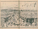
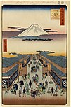
History

Hiroshige produced designs in the style of the Utagawa school, a 19th-century popular style in woodblock prints, much favoured during his lifetime. Increasingly large series of prints were produced. This trend can be seen in Hiroshige’s work, such as The Fifty-three Stations of the Tōkaidō and The Sixty-nine Stations of the Kisokaidō.
Many publishing houses arose and grew, publishing both books and individual prints. A publisher's ownership of the physical woodblocks used to print a given text or image constituted the closest equivalent to a concept of "copyright" that existed at this time.
Woodblock prints such as these were produced in large numbers in 18th- and 19th-century Japan, created by artists, block cutters and printers working independently to the instructions of specialist publishers. Prints such as these were called ukiyo-e, which means 'pictures of the floating world'. This world was one of transient delights and changing fashions centred on the licensed pleasure districts and popular theatres found in the major cities of Japan.
In the years 1829–36, a seven volume illustrated guidebook Pictures of famous places of Edo (江戸名所図会, Edo meishō zue) was published. It was begun by Saitō Yukio (1737–1799) in 1790 and illustrated very accurately by Hasegawa Settan (1778–1848). The pictures and text describe the important temples and shrines, but also the famous stores, restaurants, tea-houses etc. of Edo as well as the Sumida river and its channels and surrounding landscape.
Hiroshige, in several cases, makes use of this guide for his series of colour prints (see below and within the list). His series covered the place too which the guide didn’t describe, and he drew casual views of Edo.[1] [2] [3] His series is a work that inspired a number of Western artists, including Vincent van Gogh, to experiment with imitations of Japanese methods.[4]
The series uses a vertical format which Hiroshige pioneered in his preceding series, Famous Views of the Sixty-odd Provinces, and was a departure from the horizontal format used in his previous major print series.
-
 Suruga-chō by Hasegawa
 -
 Suruga-chō by Hiroshige
 -
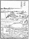 Senzoku pond
by Hasegawa -
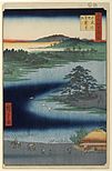 Senzoku pond
by Hiroshige


Prints
Key
- No.: number of the print; an alternative order for the summer prints in parentheses[nb 1]
- Title: as it appears on the print together with English translation and Japanese reading
- Depicted: major landmarks that appear in the print listed in order of increasing distance from the viewer
- Remarks: some general remarks on the print
- Date: publication year and month (in the pre-1873 Japanese lunisolar calendar) according to the date seal; intercalary months are preceded with "i"
- Location: place, ward[nb 2] and coordinates of the viewpoint
- Image: a picture of the print
| No. | Title | Depicted | Remarks | Date | Location | Image |
|---|---|---|---|---|---|---|
—
|
Table of Contents | —
|
Abbreviated titles of prints arranged by season: two boxes at top are spring, fan-shaped box is summer, bottom right box autumn and bottom left are winter prints | —
|
—
|

|
| 1 | Nihonbashi: Clearing after Snow (日本橋雪晴, Nihonbashi yukibare) | Nihonbashi, Edo Castle, Mount Fuji | —
|
1856 / 5 | Nihonbashi, Chūō 35°41′2.5″N 139°46′28″E / 35.684028°N 139.77444°E |

|
| 2 | Kasumigaseki (霞がせき) | Street (today Kasumigaseki-zaka), guardhouse of residence of Asano, barracks of samurai of the Kuroda clan, Edo Bay | Kadomatsu gate pines and manzai dancers indicate a setting around New Year; kite with Japanese character for fish (Jap. "sakana") is a reference to the publisher of the series, Sakanaya Eikichi | 1857 / 1 | Kasumigaseki, Chiyoda 35°40′32.4″N 139°44′56.3″E / 35.675667°N 139.748972°E |

|
| 3 | Hibiya and Soto-Sakurada from Yamashita-chō (山下町日比谷外さくら田, Yamashita-chō Hibiya Soto-Sakurada) | Residence of daimyō Nabeshima Kansō from the Saga Domain, outer moat of Edo Castle, Mount Fuji | Kadomatsu pine, hagoita and kites indicate a setting around New year | 1857 / 12 | Hibiya, Chūō 35°40′20″N 139°45′39.7″E / 35.67222°N 139.761028°E |

|
| 4 | Tsukudajima and Eitai Bridge (永代橋佃しま, Eitaibashi Tsukudajima) | Eitai Bridge, Sumida River, fishing boats of Tsukudajima | An almost identical composition titled Eitaibashi by Hiroshige exists in the second volume of his "Illustrated Souvenirs of Edo" | 1857 / 2 | Tsukuda, Chūō 35°40′39.4″N 139°47′14.7″E / 35.677611°N 139.787417°E |

|
| 5 | Ekōin Temple in Ryōgoku and Moto-Yanagi Bridge (両ごく回向院元柳橋, Ryōgoku Ekōin Moto-Yanagibashi) | Drum tower of Ekō-in, Honjo neighbourhood, Sumida River, residence of Matsudaira feudal lor of Tanba, Mount Fuji | Drum tower was associated with sumo tournaments held at Ekō-in; for marketing purposes the print appeared two months after a popular major exhibition of temple treasures at Ekō-in | 1857 / i5 | Ryōgoku, Sumida 35°41′36″N 139°47′31″E / 35.69333°N 139.79194°E |

|
| 6 | Hatsune Riding Ground in Bakuro-chō (馬喰町初音の馬場, Bakuro-chō Hatsune no baba) | Hatsune Riding Ground and district's fire watch tower | Dyers of Konya-chō district using riding grounds to dry their cloths | 1857 / 9 | Nihonbashibakuro-chō, Chūō 35°41′40.6″N 139°46′59.3″E / 35.694611°N 139.783139°E |

|
| 7 | Shops with Cotton Goods in Ōdenma-chō (大てんま町木綿店, Ōtenma-chō momendana) | Street scene with geishas, cotton shops in Ōdenma-chō | —
|
1858 / 4 | Nihonbashiōdenma-chō, Chūō 35°41′18.7″N 139°46′34.9″E / 35.688528°N 139.776361°E |

|
| 8 | Suruga-chō (する賀てふ, Suruga tefu) | Mitsui (yagō: Echigoya) textile stores, Mount Fuji | Echigoya later became the Mitsukoshi department store chain whose modern day headquarters are located on the left side of the street in the print | 1856 / 9 | Nihonbashimuro-machi, Chūō 35°41′10.5″N 139°46′26.2″E / 35.686250°N 139.773944°E |

|
| 9 | Yatsukōji, Inside Sujikai Gate (筋違内八ツ小路, Sujikai uchi Yatsukōji) | Yatsukōji junction, Kanda River, Kanda Shrine | One of the few open spaces in Edo, created as fire-breaks | 1857 / 11 | Kandata-chō, Chiyoda 35°41′50.5″N 139°46′9.2″E / 35.697361°N 139.769222°E |

|
| 10 | Sunrise at Kanda Myōjin Shrine (神田明神曙之景, Kanda Myōjin akebono no kei) | Kanda Shrine | Probably produced as a souvenir of the shrine festival in memory of the Battle of Sekigahara celebrated on the 15th day of the 9th month | 1857 / 9 | Soto-Kanda, Chiyoda 35°42′7″N 139°46′4.5″E / 35.70194°N 139.767917°E |

|
| 11 | Kiyomizu Hall and Shinobazu Pond at Ueno (上野清水堂不忍ノ池, Ueno Kiyomizu-dō Shinobazu no ike) | Kiyomizu Hall of Kan'ei-ji, Moon Pine, Shinobazu Pond | Depicted pines are in reality much smaller | 1856 / 4 | Ueno, Taitō 35°42′45.4″N 139°46′24.8″E / 35.712611°N 139.773556°E |

|
| 12 | Ueno Yamashita (上野山した) | Iseya restaurant, temples | Published in the month after Hiroshige's death; composition probably based on his sketches but probably completed by Hiroshige II | 1858 / 10 | Ueno, Taitō 35°42′38″N 139°46′24.5″E / 35.71056°N 139.773472°E |

|
| 13 | Shitaya Hirokōji (下谷広小路) | Hirokōji ("Broadway"), premises of textile retailer Matsuzakaya | Published in the same month in which the depicted Matsuzakaya store re-opened after the 1855 earthquake | 1856 / 9 | Ueno, Taitō 35°42′25.4″N 139°46′21.7″E / 35.707056°N 139.772694°E |

|
| 14 | Temple Gardens in Nippori (日暮里寺院の林泉, Nippori jiin no rinsen) | Temple Gardens | Depicts cherries and azaleas in bloom while in reality they bloom at different times of the year | 1857 / 2 | Nishinippori, Arakawa 35°43′51.8″N 139°45′57.7″E / 35.731056°N 139.766028°E |

|
| 15 | Suwa Bluff in Nippori (日暮里諏訪の台, Nippori Suwanodai) | Suwa Myōjin Shrine grounds, Mount Tsukuba | —
|
1856 / 5 | Nishinippori, Arakawa 35°43′51.1″N 139°46′1.5″E / 35.730861°N 139.767083°E |

|
| 16 | Flower Park and Dangozaka Slope in Sendagi (千駄木団子坂花屋敷, Sendagi Dangozaka Hanayashiki) | Cherry orchard, Pavilion of the Violet Spring (Shisentei) | The print is a reference to the reconstruction of the Shisentai after the 1855 earthquake and to Tokugawa Iesada's visit to the park two months prior to publication | 1856 / 5 | Sendagi, Bunkyō 35°43′30.5″N 139°45′40.4″E / 35.725139°N 139.761222°E |

|
| 17 | View to the North from Asukayama (飛鳥山北の眺望, Asukayama kita no chōbō) | Asukayama Park, Mount Tsukuba | Possibly inspired by Tokugawa Iesada's visit to the park two months prior to publication | 1856 / 5 | Asukayama Park, Kita 35°45′5″N 139°44′18″E / 35.75139°N 139.73833°E |

|
| 18 | The Ōji Inari Shrine (王子稲荷の社, Ōji Inari no yashiro) | Ōji Inari Shrine, Mount Tsukuba | —
|
1857 / 9 | Kishi-machi, Kita 35°45′21.9″N 139°44′0″E / 35.756083°N 139.73333°E |

|
| 19 | Dam on the Otonashi River at Ōji, known as "The Great Waterfall" (王子音無川堰棣 世俗大瀧ト唱, Ōji Otonashigawa entei, sezoku Ōtaki to tonau) | Otonashi River, Amida Hall of Kinrin-ji temple, Takata-chō | Likely created to mark Tokugawa Iesada's visit to Kinrin-ji (Ōji Shrine) and Takata on the 21st day of the first month (also see no. 115, 116) | 1857 / 2 | Ōji, Kita 35°45′8″N 139°44′8.7″E / 35.75222°N 139.735750°E |

|
| 20 | The Kawaguchi Ferry and Zenkōji temple (川口のわたし善光寺, Kawaguchi no watashi Zenkōji) | Arakawa River, Zenkō-ji temple | A year after Hiroshige designed the print, the Buddha in the Amida Hall at the top was due to be exhibited publicly for the first time in 13 years; in a pun Hiroshige covered the hall of this "secret Buddha" with the title cartouche | 1857 / 2 | Kita / Kawaguchi, Saitama 35°47′38″N 139°43′16.7″E / 35.79389°N 139.721306°E |

|
| 21 | Mount Atago in Shiba (芝愛宕山, Shiba Atagoyama) | Atago Shrine, Edo Bay | Scene depicts an emissary from Enpuku-ji temple who on every third day of the year performs a ceremony at Atago Shrine for good fortune, health and success and to avert hunger and disease; the large rice paddle in his hand symbolizes abundance, the seaweed around his neck was distributed after the ceremony among the faithful who used it to brew an infusion against colds | 1857 / 8 | Atago, Minato 35°39′53.2″N 139°44′54.4″E / 35.664778°N 139.748444°E |

|
| 22 | Hiroo on Furukawa River (広尾ふる川, Hiroo Furukawa) | Furukawa River, "Fox" (kitsune) restaurant | —
|
1856 / 7 | Hiroo, Shibuya 35°38′49.7″N 139°43′53.8″E / 35.647139°N 139.731611°E |

|
| 23 | Chiyogaike Pond in Meguro (目黒千代か池川, Meguro Chiyogaike) | Chiyogaike Pond | Feature a — for the time — unusual depiction of reflections of the trees in the water | 1856 / 7 | Meguro, Meguro 35°38′15″N 139°42′46″E / 35.63750°N 139.71278°E |

|
| 24 | New Fuji in Meguro (目黒新富士, Meguro Shin-Fuji) | Mita Aqueduct, Mount Fuji replica, Mount Fuji | Subject is a replica (one of many) of Mount Fuji erected in 1829 by Fuji worshippers | 1857 / 4 | Nakameguro, Meguro 35°38′36.5″N 139°42′17.5″E / 35.643472°N 139.704861°E |

|
| 25 | The Original Fuji in Meguro (目黒元不二, Meguro Moto-Fuji) | Mount Fuji replica, Mount Fuji | Fuji replica erected in 1812 was at 12 m (39 ft) the tallest in Edo; this print was incorrectly placed in the spring section of the table of contents since the depicted cherry trees are in autumn foliage; spelling of "Fuji" in the title as (不二, lit. "not two") is thought to be a pun on the doubling of the mountain | 1857 / 4 | Kamimeguro, Meguro 35°38′48″N 139°42′3.7″E / 35.64667°N 139.701028°E |

|
| 26 | The "Armour-Hanging Pine" at Hakkeizaka Bluff (八景坂鎧掛松, Hakkeizaka Yoroikakematsu) | Tōkaidō, Edo Bay | Depicts a popular viewpoint of Edo Bay; according to legend, Minamoto no Yoshiie hung his armour on this tree in 1062; Hiroshige adapts the shape of the tree so that only a giant could have hung his armour on it | 1856 / 5 | Ōmorikita, Ōta 35°35′18.6″N 139°43′36.7″E / 35.588500°N 139.726861°E |

|
| 27 | Plum Orchard in Kamada (蒲田の梅園, Kamada no umezono) | Plum Orchard in Kamada | —
|
1857 / 2 | Kamata, Ōta 35°33′53″N 139°43′37″E / 35.56472°N 139.72694°E |

|
| 28 | Palace Hill in Shinagawa (品川御殿やま, Shinagawa Gotenyama) | Palace Hill | Depicts both a famous cherry blossom spot and the destruction of the landscape after removal of earth; the earth was used to build ramparts (daiba) in the sea following Commodore Perry's arrival in Edo Bay in 1853 | 1856 / 4 | Kita-shinagawa, Shibuya 35°37′15.7″N 139°44′22.2″E / 35.621028°N 139.739500°E |

|
| 29 | Moto-Hachiman Shrine in Sunamura (砂むら元八まん, Sunamura Moto-Hachiman) | Torii of Moto-Hachiman Shrine, Edo Bay | —
|
1856 / 4 | Minami-suna, Kōtō 35°40′9.4″N 139°50′15.6″E / 35.669278°N 139.837667°E |

|
| 30 | Plum Park in Kameido (亀戸梅屋舗, Kameido Umeyashiki) | Plum Park in Kameido | Both in color and theme this print is related to print no. 27 (Plum Orchard in Kamada); copied by Vincent van Gogh under the title Japonaiserie: Flowering Plum Tree | 1857 / 11 | Kameido, Kōtō 35°42′16.3″N 139°49′26.1″E / 35.704528°N 139.823917°E |
|
| 31 | Azuma no mori Shrine and the Entwined Camphor (吾嬬の森連理の梓, Azuma no mori Renri no azusa) | Azuma Shrine | —
|
1856 / 7 | Tachibana, Sumida 35°42′19.9″N 139°49′36.4″E / 35.705528°N 139.826778°E |

|
| 32 | The Yanagishima (柳しま, Yanagishima) | Myōken Hall of Hōshō-ji temple, Hashimotoya restaurant ("At the Foot of the Bridge"), Mount Tsukuba | —
|
1857 / 4 | Narihira, Sumida 35°42′27.3″N 139°49′5.9″E / 35.707583°N 139.818306°E |

|
| 33 | Towboats Along the Yotsugi-dōri Canal (四ツ木通用水引ふね, Yotsugi dōri yōsui hikifune) | Yotsugi-dōri Canal towpath | Unlike in the print, the canal and towpath were absolutely straight | 1857 / 2 | Yotsugi, Katsushika 35°44′7.7″N 139°50′4″E / 35.735472°N 139.83444°E |

|
| 34 | Night View of Matsuchiyama and the San'ya Canal (真乳山山谷堀夜景, Matsuchiyama San'yabori yakei) | Sumida River, San'ya Canal inlet, Yumeiro and Takeya restaurants, Matsuchiyama hill, Shōten Shrine | Only image in the series to depict a large human figure, purportedly the favourite geisha of Hiroshige; Shōten Shrine on the top of the hill has sexual connotations | 1857 / 8 | Asakusa, Taitō 35°42′57.3″N 139°48′23.3″E / 35.715917°N 139.806472°E |

|
| 35 | Suijin Shrine and Massaki on the Sumida River (隅田川水神の森真崎, Sumidagawa Suijin no mori Massaki) | Cherry tree trunk, Suijin Shrine, Sumida River, Massaki district, Mount Tsukuba | People at the bottom of the print are on the way to the Hashiba ferry (see no. 37) | 1856 / 8 | Tsutsumidōri, Sumida and Minamisenju, Arakawa 35°43′58″N 139°48′45.8″E / 35.73278°N 139.812722°E |

|
| 36 | View From Massaki of Suijin Shrine, Uchigawa Inlet, and Sekiya (真崎辺より水神の森内川関屋の里を見る図, Massaki atari yori Suijin no mori Uchigawa Sekiya no sato wo miru zu) | Sumida River, Suijin Shrine, Massaki district, Mount Tsukuba | Similar subject and location as no. 35 | 1857 / 8 | Minamisenju, Arakawa 35°43′47″N 139°48′30.3″E / 35.72972°N 139.808417°E |

|
| 37 | Kilns and the Hashiba Ferry on the Sumida River (墨田河橋場の渡かわら竈, Sumidagawa hashiba no watashi kawaragama) | Kilns, Sumida River, Suijin Shrine, Mount Tsukuba | Similar area as no. 35, 36 | 1857 / 4 | Minamisenju, Arakawa / Hashiba, Taitō / Tsutsumidōri, Sumida 35°43′41″N 139°48′35″E / 35.72806°N 139.80972°E |

|
| 38 | Dawn Inside the Yoshiwara (廓中東雲, Kakuchū shinonome) | Yoshiwara | Published two months prior to the reopening of Yoshiwara after it burnt down in the 1855 earthquake; Hiroshige may have submitted this design and title following the suicide of two courtesans and their two lovers at dawn of the 19th day of the 4th month of 1857 | 1857 / 4 | Asakusa, Taitō 35°43′27.2″N 139°47′45.9″E / 35.724222°N 139.796083°E |

|
| 39 | Distant View of Kinryūzan Temple and the Azuma Bridge (吾妻橋金龍山遠望, Azumabashi Kinryūzan enbo) | Sumida River, Azuma Bridge, Kinryūzan Temple, Mount Fuji | —
|
1857 / 8 | Asakusa, Taitō 35°42′52″N 139°48′15″E / 35.71444°N 139.80417°E |

|
| 40 | Bashō's Hermitage on Camellia Hill beside the Aqueduct at Sekiguchi (せき口上水端はせを庵椿やま, Sekiguchi jōsuibata Bashōan Tsubakiyama) | Sekiguchi Aqueduct, Bashō's Hermitage | —
|
1857 / 4 | Sekiguchi, Bunkyō 35°42′44.3″N 139°43′24.6″E / 35.712306°N 139.723500°E |

|
| 41 | Hachiman Shrine in Ichigaya (市ヶ谷八幡, Ichigaya Hachiman) | Ichigaya moat, shopping street, Hachiman Shrine | Dated one month after Hiroshige's death and therefore attributed to Hiroshige II by some art historians | 1858 / 10 | Ichigayahachiman-chō, Shinjuku 35°41′33.8″N 139°44′1.5″E / 35.692722°N 139.733750°E |

|
| 42 | Cherry Blossoms on the Banks of the Tama River (玉川堤の花, Tamagawa tsutsumi no hana) | Actually, the Tama River-Jōsui channel is depicted, with cherry trees far outside Edo | One of the first five prints sanctioned by the censors | 1856 / 2 | Shinjuku, Shinjuku 35°41′21.6″N 139°42′8″E / 35.689333°N 139.70222°E |

|
| 43 | Nihonbashi Bridge and Edobashi Bridge (日本橋江戸ばし, Nihonbashi Edobashi) | Nihonbashi, Nihonbashi River, Edobashi | Fish barrel with first bonito of the season represents early summer | 1857 / 12 | Nihonbashi, Chūō 35°41′3.2″N 139°46′28.8″E / 35.684222°N 139.774667°E |

|
| 44 | View of Nihonbashi itchōme Street (日本橋通一丁目略図, Nihonbashi Tōri itchōme ryakuzu) | Nihonbashi itchōme Street | Shirokiya shop on the right developed into one of the city's largest department stores and finally became part of the Tokyu Group | 1858 / 8 | Nihonbashi, Chūō 35°40′57″N 139°46′23.7″E / 35.68250°N 139.773250°E |

|
| 45 (62) | Yatsumi Bridge (八ツ見のはし, Yatsumi no hashi) | Yatsumi Bridge, Edo Castle, Mount Fuji | —
|
1856 / 8 | Yaesu and Nihonbashihongoku-chō, Chūō 35°41′4.7″N 139°46′16.8″E / 35.684639°N 139.771333°E |

|
| 46 (45) | Yoroi Ferry, Koami-chō (鎧の渡し小網町, Yoroi no watashi Koami-chō) | Nihonbashi River, Yoroi ferry | —
|
1857 / 10 | Nihonbashikoami-chō, Chūō 35°40′56.1″N 139°46′47.9″E / 35.682250°N 139.779972°E |

|
| 47 (46) | Seidō and Kanda River from Shōhei Bridge (昌平橋聖堂神田川, Shōheibashi Seidō Kandagawa) | Shōhei Bridge, Shōheizaka hill, Kanda River, wall of Yushima Seidō | Exaggerated size of hill on left | 1857 / 9 | Yushima, Bunkyō 35°41′54″N 139°46′8″E / 35.69833°N 139.76889°E |

|
| 48 (63) | Suidō Bridge and the Surugadai Quarter (水道橋駿河台, Suidōbashi Surugadai) | View from Surugadai, Kanda River, Suidō Bridge, Edo Castle, Mount Fuji | Koinobori carp streamers place the scene around the Boy's festival on the 5th day of the 5th month, the same month as the print was approved by the censors | 1857 / i5 | Surugadai, Chiyoda 35°42′7.5″N 139°45′19″E / 35.702083°N 139.75528°E |

|
| 49 (47) | Fudō Falls in Ōji (王子不動之滝, Ōji Fudō no taki) | Fudō Falls | Zdroj:https://en.wikipedia.org?pojem=One_Hundred_Famous_Views_of_Edo